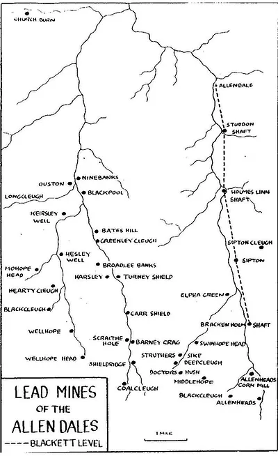
Map of the lead mines in the Allen Dales following the rivers and the site of the Blackett level.

-
Description
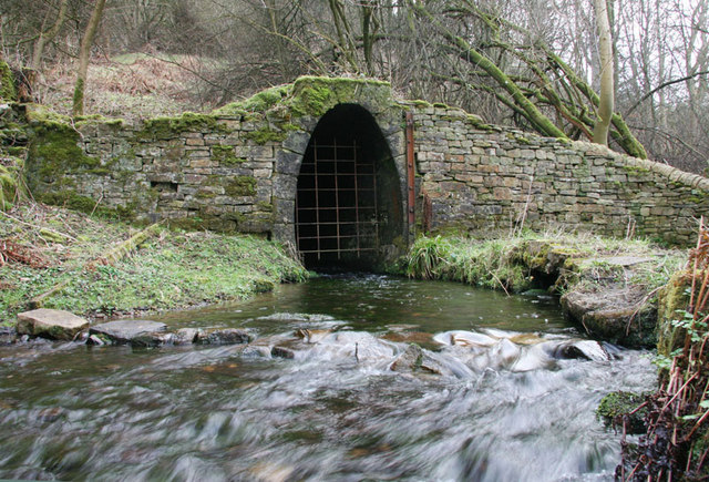
The ‘Blackett Level’ is a tunnel built to help drain the local mines (known as an ‘adit’), it was also hoped that the tunnel would help to discover further lead veins. The dimensions of the tunnel were originally 8.5ft by 5 feet as can be seen in the arched portal (the entrance to the level) located near the footpath which follows the East Allen river from Allen Mill to Allendale where the remains of a stone built two storey building can also be seen. When walking along the path from Allen Mill to Allendale the arched portal is on the left just before the small bridge over the river. Work on the adit level began in 1859 but by 1863 the scale of the level was seen as too costly and the tunnel size was reduced to 6.25 ft by 4 ft. The level travels up the Allen Valley for 4.5 miles. It was hoped that that it would go all the way to Allenheads but construction stopped in 1903 with the collapse of the lead mining industry. If it had been completed it would have been 7 miles long. Four shafts were constructed, one at Studdon Dene (88ft deep), one at Holmes Lynn (330 ft deep), one at Sipton (192 ft deep) and one at Breckon Hill (430 ft deep) although not all sources quote the same depths. Unfortunately, the Blackett Level did not yield the results that had been hoped for and the only mines originating from the exploration were at St Peter’s and Sipton (the ore from these mines was smelted here at Allen Mill). The project was successful in lowering the water table however making it possible for the local mines to continue long after others had shut down. There were no roads in the West Allen until 1826 so the lead ore was brought to the smelt mill over the moors in sacks on the backs of ponies known as ‘galloways’ (2 hundred weight per pony) except in the winter when the ground was soft and the load had to be lighter which doubled the cost of transport as more ponies and more men were needed to transport the ore. Coal was also required to smelt the ore and in 1865 records show 36 coal workings in the parish of Allendale although only one, the Stublick Colliery is recorded as being used for smelting. The railway came to Catton in 1869 and a connecting line between the station and the mill yard was built in 1896 which considerably eased the transportation problems both to and from the mill. -
Owner
Allen Mill -
Source
Local (Co-Curate) -
License
What does this mean? Unknown license check permission to reuse
-
Further information
Link: https://web.archive.org/web/20201011151048/http://www.allenmill.co.uk/blacket-level
Resource type: Text/Website
Added by: Simon Cotterill
Last modified: 1 month, 1 week ago
Viewed: 126 times
Picture Taken: Unknown -
Co-Curate tags


