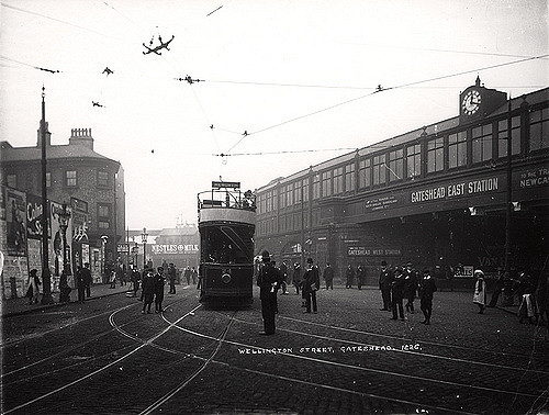
Topics > Tyne and Wear > Gateshead > Whickham > Old Hollinside
Old Hollinside
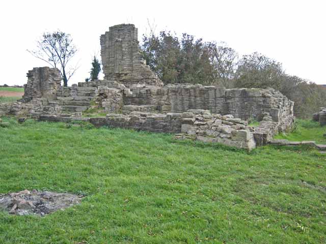
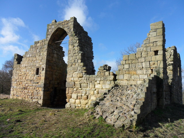 A 13th Century fortified manor house. Old Hollinside is a substantial ruin on the edge of the River Derwent valley, located just over a mile south-west of Whickham. The manor house was owned by the Harding family from the 15th century until the 18th century, when in 1730, it became part of the Gibside estate of the Bowes family.[1] Old Hollinside is Grade I listed on the National Heritage List for England and is also a Scheduled Monument (legally protected).
Scheduled Monument (#1018679): Old Hollinside fortified hall house, Whickham
Click the headings below to expand (selected extracts from the Historic England scheduling)
Fortified houses were residences belonging to some of the richest and most powerful members of society. Their design reflects a combination of domestic and military elements. In some instances, the fortifications may be cosmetic additions to an otherwise conventional high status dwelling, giving a military aspect while remaining practically indefensible. They are associated with individuals or families of high status and their ostentatious architecture often reflects a high level of expenditure. The nature of the fortification varies, but can include moats, curtain walls, a gatehouse and other towers, gunports and crenellated parapets.
Old Hollinside is a well-preserved example of a medieval fortified hall house in a prominent position and will provide evidence on the evolution of fortified medieval complexes. The monument has an association with a number of well-known historical families.
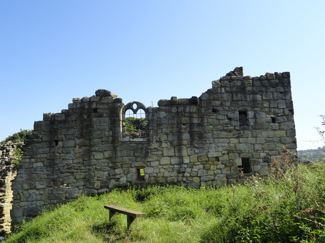
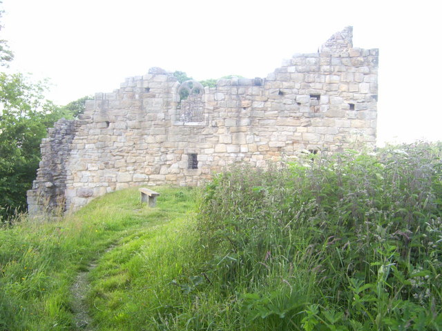
The monument includes the medieval fortified house, which is known as Old Hollinside. It is situated on the crest of a north facing steep slope above the Derwent valley and 150m south west of the modern farm of Hollinside. The remains, the standing parts of which are Listed Grade I, include a ruined fortified hall house, an attached wing to the north east and associated earthworks. The hall house was constructed in several phases, dating from the late 13th century to around 1400.
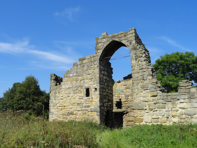
The hall house is orientated north east to south west along its long axis. It is of sandstone construction, measures 16m by 11m with a turret in its western corner. To the exterior, the majority of the walls stand to a height of 6m, although on the south eastern elevation they survive to a height of approximately 9m-10m. All four elevations are constructed of roughly coursed sandstone blocks, with squared sandstone blocks above first floor level on the south west and north west sides. There are a number of window openings on each side and on the south west elevation two corbels at second floor level are believed to have supported an oriel window. The main doorway into the hall is on the south east side. It is set in a recess between two shallow projecting wings which later was subdivided by a screen wall to form a lobby in front of the original entrance. The space between the wings was roofed over by a spring vault carrying a tower. Above the doorway there is a hollow, believed to have carried a coat of arms stone.
Internally the house can be divided into five parts, the lobby, a hall, a south wing, an east wing and the western turret. The walls have some plaster on them and the remains of an inserted fireplace survive at first floor level. The first floor of the house was carried on a set back running the length of the north west wall and on beams that fitted into sockets, four of which survive. The north east wing of the house is an`L' shaped structure, which extends to the north east and east. It is constructed of tabular sandstone blocks and its eastern arm survives to a height of about 2m. The northern side of the wing is not upstanding but survives as an earthwork with sections of walling evident on its surface.
Earthworks can be seen to the north east, south east and south west of the hall house, and additional earthworks are recorded on the first edition 1:2500 Ordnance Survey map and on tithe maps. The earthworks include a remnant field boundary and two banks that correspond with a 35m square enclosure indicated on the Ordnance Survey map to the south east of the hall.
On the south east side of this enclosure a gatehouse was shown measuring 20m by 10m, which was the main access to the house. The gatehouse is depicted as a roofed structure on tithe maps of 1767 and 1803. The 1767 tithe map also depicts an undefined structure to the north east of the house, which is interpreted as a courtyard and is included in the scheduling. The Ordnance Survey map shows earthwork field boundaries and marks `foundations' in the area between Old Hollinside and Hollinside Farm. A sample of this area is also included in the scheduling. The first reference to the monument is in 1317 when Thomas de Hollinside granted his manor of Hollinside to William de Boineton of Newcastle and Isolda, his wife.
The property was owned by the Hardings from the 15th century until the 18th century, when it became part of the Gibside estate of the Bowes family. The monument was consolidated in the mid-1970s and in the early 1980s.


from https://historicengland.org.u…
OLD HOLLINSIDE
- "Fortified Manor House. Possibly C13. Sandstone rubble; coursed squared sandstone lower part. Quoins, larger in lower sections. Plan: hall with small chamber at south-west, larger chambers at south-east and north- …
Added by
Simon Cotterill

from http://www.twsitelines.info/S…
Tyne and Wear HER(107): Whickham, Old Hollinside
- "When first built, perhaps in the 13th century, the house was an oblong, 16.15 x 6.65 metres externally, with walls 0.90 metres thick, with 2 rooms (hall and chamber) on …
Added by
Simon Cotterill
from http://www.gatehouse-gazettee…
OLD HOLLINSIDE
- "Old Hollinside is a well-preserved example of a medieval fortified hall house in a prominent position and will provide evidence on the evolution of fortified medieval complexes. The monument has …
Added by
Simon Cotterill
Co-Curate Page
Gibside
- Overview About Gibside Map Street View Gibside is a country estate, set amongst the peaks and slopes of the Derwent Valley, between Rowlands Gill, Tyne and Wear and Burnopfield, …

from https://historicengland.org.u…
OLD HOLLINSIDE
- "Fortified Manor House. Possibly C13. Sandstone rubble; coursed squared sandstone lower part. Quoins, larger in lower sections. Plan: hall with small chamber at south-west, larger chambers at south-east and north- …
Added by
Simon Cotterill
from http://www.twsitelines.info/S…
Tyne and Wear HER(107): Whickham, Old Hollinside
- "When first built, perhaps in the 13th century, the house was an oblong, 16.15 x 6.65 metres externally, with walls 0.90 metres thick, with 2 rooms (hall and chamber) on …
Added by
Simon Cotterill
from http://www.gatehouse-gazettee…
OLD HOLLINSIDE
- "Old Hollinside is a well-preserved example of a medieval fortified hall house in a prominent position and will provide evidence on the evolution of fortified medieval complexes. The monument has …
Added by
Simon Cotterill