Topics > Northumberland > Berwick upon Tweed > Historic Buildings and Monuments in Berwick upon Tweed
Historic Buildings and Monuments in Berwick upon Tweed
Listed buildings and scheduled monuments in Berwick upon Tweed, Northumberland, from the National Heritage List for England[1]. Use the Search (below) if looking for a specific building / monument.
| Structure | List No. | Grade | Built~ | Note |
|---|---|---|---|---|
| The Site of The Battle of Halidon Hill 1333 | 1000012 | n/a | 1333 | Historic Battlefield |
| Halidon Hill settlement | 1003657 | n/a | Iron Age | Scheduled Monument |
| Medieval church and graveyard 330m north west of Berwick Castle | 1019902 | n/a | Medieval | Scheduled Monument |
| Spades Mire linear earthwork and section of rig and furrow | 1015521 | n/a | Medieval | Scheduled Monument. Earthwork defences, pre town wall |
| Enclosure castle, two 16th century gun turrets and an early 17th century house | 1015520 | n/a | C16th | Scheduled Monument |
| Monastic site identified as St Leonard's Nunnery | 1416290 | n/a | Scheduled Monument | |
| Springhill Roman camp | 1003655 | n/a | Roman?? | Scheduled Monument |
| Camphill settlement | 1003658 | n/a | Iron Age | Scheduled Monument |
| Nos. 1 and 2, Greenside Avenue | 1042483 | II | ||
| Nos. 1 and 3, Hide Hill | 1211259 | II | ||
| Nos. 1 and 3, Ravensdowne | 1042441 | II | Ravensdowne | |
| Nos. 1 and 3, Walkergate | 1233740 | II | ||
| Nos. 1, 3, 3A, 3B and 3C, Wallace Green | 1233675 | II | ||
| No. 1, Bridge Terrace | 1041671 | II | ||
| No. 1, Wellington Terrace | 1276502 | II* | ||
| Nos. 1-3, St Mary's Place | 1233711 | II | ||
| Nos. 1-5, Bridge Street | 1290176 | II | ||
| Nos. 1-7, Scott's Place | 1233670 | II | ||
| Nos. 1-9, Church Street | 1370830 | II | ||
| Nos. 1-9, Marygate | 1370865 | II | ||
| Nos. 10 and 12, Hide Hill | 1211360 | II | ||
| No. 10, Sandgate | 1233669 | II | Sandgate | |
| Nos. 10-13, Quay Walls | 1042436 | II | ||
| Nos. 10-14, Ravensdowne | 1042404 | II | Ravensdowne | |
| Nos. 101-109, Marygate | 1042488 | II | ||
| Nos. 11 and 13, Castlegate | 1041676 | II | Castlegate | |
| No. 11, Ravensdowne | 1370853 | II | Ravensdowne | |
| No. 11, Sandgate | 1233666 | II | Sandgate | |
| No. 11, Wedell's Lane | 1233747 | II | ||
| Nos. 11-15, Church Street | 1042473 | II | ||
| Nos. 114, 116 and 116A, Marygate | 1042447 | II | ||
| Nos. 12 and 14, Bridge Street | 1041657 | II | ||
| No. 12, Tweed Street | 1233673 | II | ||
| Nos. 12-18, Marygate | 1370837 | II | ||
| Nos. 12-18, Parade | 1042431 | II | ||
| Nos. 124 and 126, Marygate | 1233793 | II | ||
| Nos. 13 and 15, Bridge Street | 1041665 | II | ||
| No. 13, Ravensdowne | 1289988 | II | Ravensdowne | |
| No. 13, Sandgate | 1276499 | II | Sandgate | |
| Nos. 13-19, West Street | 1276503 | II | ||
| No. 14, Ness Street | 1042449 | II | ||
| No. 14, Palace Green | 1042467 | II | Palace Green | |
| No. 14, Palace Street | 1370887 | II | ||
| Nos. 14-20, Hide Hill | 1370862 | II | ||
| Nos. 15 and 17, Ravensdowne | 1042443 | II | Ravensdowne | |
| No. 15, Hide Hill | 1042454 | II | ||
| Nos. 16 and 17, Quay Walls | 1233771 | II | ||
| Nos. 16 and 18, Bridge Street | 1371246 | II | ||
| Nos. 16 and 18, Eastern Lane | 1042481 | II | ||
| No. 16, Ravensdowne | 1370876 | II | Ravensdowne | |
| Nos. 16-20, Ness Street | 1042450 | II | ||
| No. 17, Bridge Street | 1290181 | II | ||
| No. 17, Church Street | 1042474 | II | ||
| Nos. 178-180, Main Street | 1393639 | II | ||
| No. 18, Ravensdowne | 1211524 | II | Ravensdowne | |
| Nos. 18-22, West Street | 1276505 | II | ||
| No. 19, Church Street | 1370831 | II | ||
| No. 19, Quay Walls | 1290012 | II* | ||
| Nos. 2 and 2a, Brewery Bank | 1276449 | II | ||
| Nos. 2 and 4, Eastern Lane | 1211246 | II | ||
| Nos. 2 and 4, Hide Hill | 1370861 | II | ||
| Nos. 2 and 4, Parade | 1042430 | II | ||
| Nos. 2 and 4, Ravensdowne | 1370875 | II* | Ravensdowne | |
| Nos. 2 and 4, West Street | 1233683 | II | ||
| No. 2, Love Lane | 1042460 | II | ||
| No. 2, Marygate | 1211320 | II | ||
| No. 2, Palace Green | 1042452 | II | Palace Green | |
| No. 2, Quay Walls | 1233691 | II | ||
| No. 2, Wellington Terrace | 1233749 | II* | ||
| Nos. 2-12, Bridge End | 1041656 | II | ||
| Nos. 2-12, Ness Street | 1370857 | II | ||
| Nos. 2-6, Bridge Street | 1371245 | II | ||
| Nos. 20 and 22, Parade | 1211451 | II | ||
| No. 20, Main Street | 1211378 | II | ||
| No. 20, Quay Walls | 1042438 | II* | ||
| No. 20, Ravensdowne | 1042405 | II | Ravensdowne | |
| Nos. 23 and 25, Church Street | 1042475 | II | ||
| No. 23, Castlegate | 1211160 | II | Castlegate | |
| Nos. 24 and 26, West Street | 1233769 | II | ||
| No. 24, Bridge Street | 1041658 | II | ||
| Nos. 25 and 25a, Bridge Street | 1041666 | II | ||
| Nos. 25 and 27, Palace Street | 1042426 | II | ||
| Nos. 26 and 28, Hide Hill | 1290034 | II | ||
| No. 26, Bridge Street | 1041659 | II | ||
| No. 26, Marygate | 1042490 | II | ||
| No. 26, Ravensdowne | 1042406 | II | Ravensdowne | |
| No. 27, Church Street | 1370832 | II | ||
| Nos. 27-33, Bridge Street | 1041667 | II | ||
| Nos. 28 and 30, West Street | 1233684 | II | ||
| Nos. 3 and 5, Castlegate | 1211156 | II | Castlegate | |
| No. 3, Avenue | 1371225 | II | ||
| No. 3, Eastern Lane | 1042480 | II | ||
| No. 3, Love Lane | 1290035 | II | ||
| No. 3, Palace Green | 1370866 | II | Palace Green | |
| No. 3, Quay Walls | 1276440 | II | ||
| No. 3, West Street | 1233752 | II | ||
| No. 30, Bridge Street | 1371247 | II | ||
| No. 30, Ravensdowne | 1289959 | II | C18th | Ravensdowne |
| Nos. 30-36, Hide Hill | 1042457 | II | ||
| Nos. 32-36, Bridge Street | 1041660 | II | ||
| Nos. 32-36, West Street | 1276506 | II | ||
| Nos. 33 and 35, West Street | 1233762 | II | ||
| Nos. 33 and 37, Ravensdowne | 1211503 | II* | Ravensdowne | |
| No. 35, Wool Market | 1233685 | II | ||
| No. 36, Foul Ford | 1042482 | II | ||
| No. 37, Marygate | 1042484 | II | ||
| Nos. 37-41, Wool Market | 1233795 | II | ||
| Nos. 38 and 40, Ravensdowne | 1211528 | II | Ravensdowne | |
| Nos. 39 and 41, Church Street | 1211234 | II | ||
| No. 39, Marygate | 1042485 | II | ||
| No. 39, Ravensdowne | 1042444 | II | Ravensdowne | |
| No. 4, College Place | 1393941 | II | ||
| No. 4, Main Street | 1042461 | II* | ||
| No. 4, Palace Green | 1370860 | II | Palace Green | |
| No. 4, Quay Walls | 1042433 | II* | ||
| Nos. 4-10, Marygate | 1042489 | II | ||
| Nos. 4-8, Castlegate | 1290156 | II | Castlegate | |
| No. 40, Eastern Lane | 1276438 | II | ||
| Nos. 40-46, Bridge Street | 1371248 | II | ||
| Nos. 41 and 43, Bridge Street | 1290185 | II | ||
| Nos. 41 and 43, Marygate | 1211282 | II | ||
| No. 41, Ravensdowne | 1370854 | II | Ravensdowne | |
| Nos. 43, 45 and 45a, Wool Market | 1276443 | II | ||
| No. 43, Church Street | 1042476 | II | ||
| No. 44, Ravensdowne | 1042407 | II | Ravensdowne | |
| Nos. 45 to 53, Bridge Street | 1041669 | II | ||
| Nos. 45-51, Marygate | 1370834 | II | ||
| No. 46, Main Street | 1042463 | II | ||
| No. 46, Ravensdowne | 1370878 | II | Ravensdowne | |
| Nos. 47-51, Church Street | 1290127 | II | ||
| No. 48, Ravensdowne | 1211538 | II | Ravensdowne | |
| No. 48, Tweed Street | 1233674 | II | ||
| Nos. 48-52, Bridge Street | 1041661 | II | ||
| Nos. 48-52, Main Street | 1370863 | II | ||
| Nos. 5 and 7, Hide Hill | 1042453 | II | ||
| No. 5, Ness Street | 1042448 | II | ||
| No. 5, Quay Walls | 1290009 | II* | ||
| No. 50, Ravensdowne | 1042408 | II | Ravensdowne | |
| Nos. 50-54, Hide Hill | 1042458 | II | ||
| Nos. 51 and 53, Ravensdowne | 1289991 | II | Ravensdowne | |
| Nos. 52 and 54, Ravensdowne | 1211541 | II* | Ravensdowne | |
| Nos. 53-61, Marygate | 1211286 | II | ||
| Nos. 54-60, Bridge Street | 1041662 | II | ||
| Nos. 55 and 57, Bridge Street | 1041670 | II | ||
| No. 55, Ravensdowne | 1042445 | II | Ravensdowne | |
| Nos. 56 and 58, Ravensdowne | 1042409 | II | Ravensdowne | |
| Nos. 56-62, Main Street | 1211385 | II | ||
| No. 57, Church Street | 1370833 | II | ||
| No. 57, West Street | 1233682 | II | ||
| Nos. 58 and 60, Church Street | 1370867 | II | ||
| No. 58j, Church Street | 1042468 | II | ||
| Nos. 59 and 61, Bridge Street | 1211118 | II | ||
| Nos. 6 and 7, Quay Walls | 1370852 | II | ||
| Nos. 6 and 8, Hide Hill | 1042455 | II | ||
| Nos. 6 and 8, Ravensdowne | 1289957 | II | Ravensdowne | |
| No. 6, Palace Street East | 1370889 | II | Palace Street East | |
| Nos. 6-10, Parade | 1370850 | II | ||
| Nos. 6-12, West Street | 1233767 | II | ||
| No. 60, Ravensdowne | 1370879 | II | Ravensdowne | |
| No. 62, Bridge Street | 1371249 | II | ||
| No. 63, Marygate | 1042486 | II | ||
| No. 63, Ravensdowne | 1370855 | II | Ravensdowne | |
| Nos. 64 and 66, Main Street | 1042464 | II | ||
| No. 64, Bridge Street | 1041663 | II | ||
| No. 64, West Street | 1264038 | II | ||
| Nos. 65 and 67, Marygate | 1370835 | II | ||
| Nos. 66 and 68, Ravensdowne | 1276473 | II | Ravensdowne | |
| Nos. 66, 66a and 68, Church Street | 1370868 | II | ||
| No. 66, Bridge Street | 1371250 | II | ||
| Nos. 7 and 9, Castlegate | 1371253 | II | Castlegate | |
| No. 7, Bridge Street | 1041664 | II | ||
| No. 7, Ravensdowne | 1042442 | II | Ravensdowne | |
| Nos. 70 and 70A, Church Street | 1042470 | II | ||
| Nos. 71 and 73, Ravensdowne | 1042403 | II | Ravensdowne | |
| No. 72, Ravensdowne | 1233664 | II | Ravensdowne | |
| Nos. 72-80, Main Street | 1042465 | II | ||
| No. 74, Church Street | 1042471 | II | ||
| No. 75, Ravensdowne | 1211519 | II | Ravensdowne | |
| No. 76, Church Street | 1370869 | II | ||
| Nos. 77a and 79, Marygate | 1290084 | II | ||
| Nos. 8 and 10, Palace Green | 1211413 | II | Palace Green | |
| No. 8, Quay Walls | 1042434 | II | ||
| Nos. 81-85, Marygate | 1042487 | II | ||
| No. 84, Church Street | 1042472 | II | ||
| No. 84, Main Street | 1370864 | II | ||
| No. 8a, Quay Walls | 1290010 | II | ||
| Nos. 9 and 11, Bridge Street | 1211096 | II | ||
| No. 9, Quay Walls | 1042435 | II | ||
| Nos. 9-13, Hide Hill | 1211356 | II | ||
| No. 91, Marygate | 1290087 | II | ||
| Nos. 94, 94a, 100 and 102, Marygate | 1233699 | II | ||
| A Group of Cottages in Long Narrow Yard Leading to Number 58 (11/60) | 1233790 | II | ||
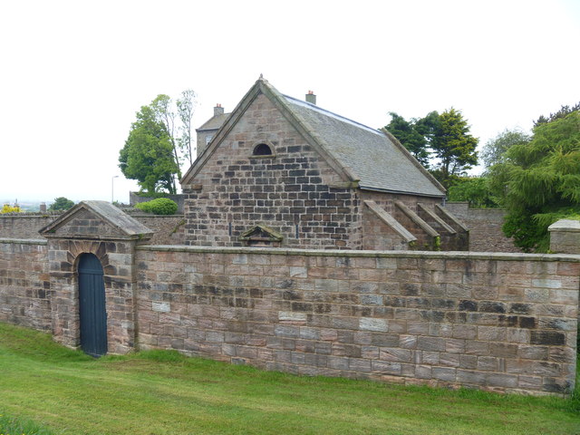
| Avenue House | 1042429 | II | C18th | Palace Street East |
| Barclays Bank | 1042456 | II | ||
| Bell Tower and Remains of Town Walls | 1370858 | I | 1577 | |
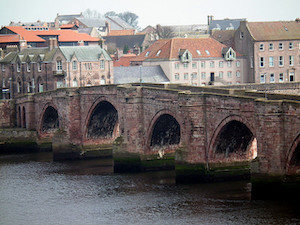
| Berwick Bridge | 1041695 | I | 1634 | Scheduled Monument(1003654) |
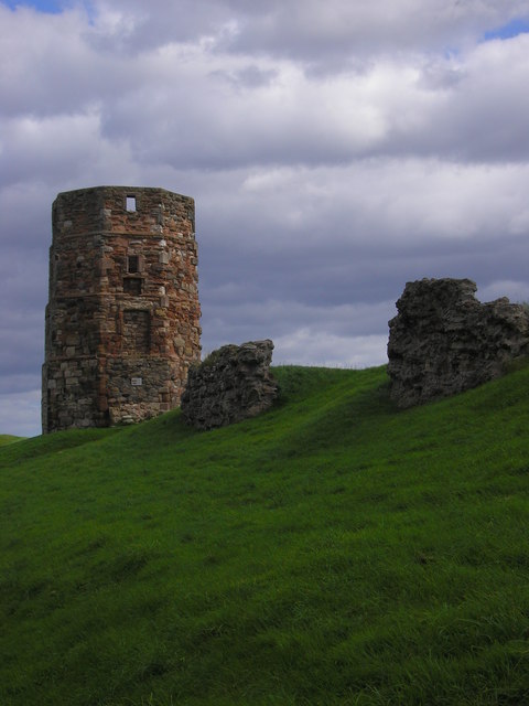
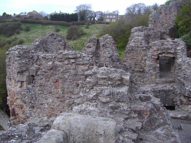
| Berwick Castle Ruins of the Constable Tower | 1371223 | I | ||
| Berwick Castle (Fragments, Including Towers and Walls and Steps) | 1290213 | I | C12th | Ruins. Scheduled Monument(1015968) |
| Berwick House | 1290151 | II | ||
| Berwick Scout Hall and Attached Dwarf Wall and Gates | 1042451 | II | Palace Green | |
| Berwick Upon Tweed Social and Labour Club | 1233665 | II | ||
| Bower Villa | 1042424 | II | ||
| Boys' National School | 1289987 | II | 1842 | Ravensdowne |
| Bust in Medallion Set in Garden Wall West of Castle Hills House | 1211464 | II | ||
| Castle Hills House | 1370851 | II | ||
| Cellars beneath 10-14 (even) Silver Street | 1405086 | II | ||
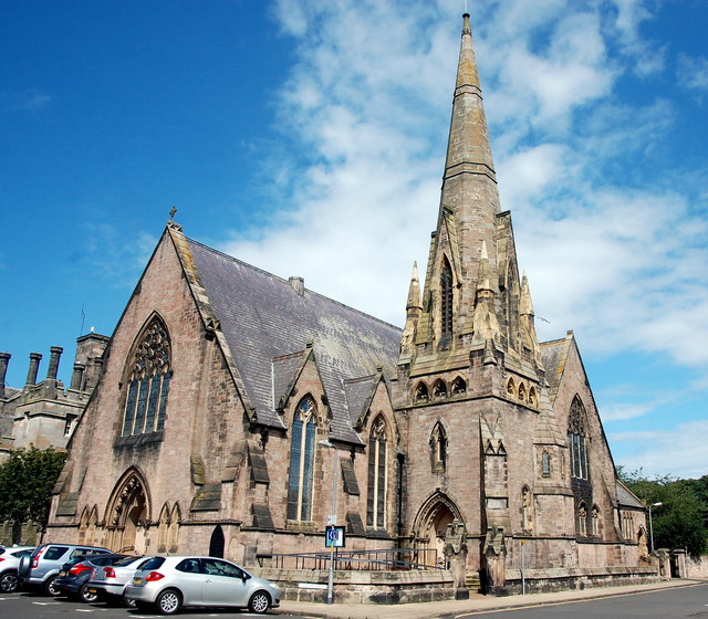
| Church of Holy Trinity | 1233676 | I | 1652 | |
| Church of Scotland | 1233742 | II | 1859 | Wallace Green |
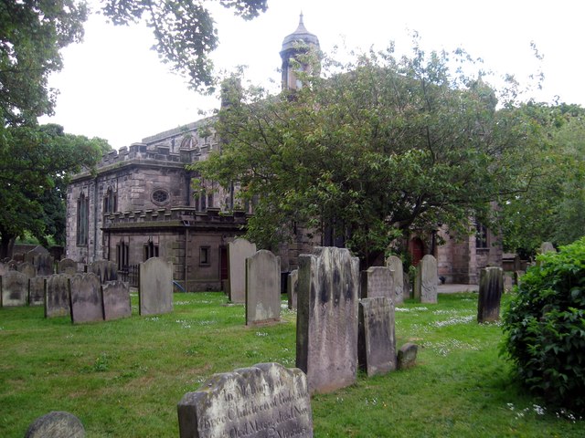
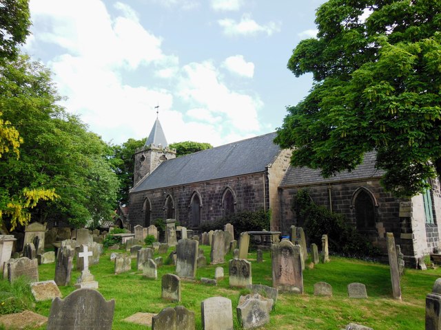
| Church of St Bartholomew and St Boisil | 1041677 | II | 1783 | Built of the site of an earlier church. |
| Classical Statue | 1393926 | II | ||
| Cleadon | 1370886 | II | ||
| Clifford House | 1042462 | II | ||
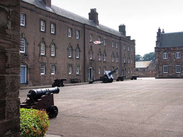
| Clock House Building, Berwick Barracks Museum | 1244772 | I | 1741 | |
| Club House | 1393927 | II | ||
| Conduit Head | 1041673 | II | ||
| Corporation Arms Inn | 1042459 | II | ||
| Customs Watch House | 1410505 | II | ||
| Eagle House | 1211498 | II | ||
| East Barrack, Berwick Barracks Museum | 1042432 | I | 1721 | |
| Edina House | 1042439 | II* | ||
| Entrance Gateway to Military Hospital | 1042402 | II* | Ravensdowne | |
| Entry to Numbers 61a and 61b | 1211516 | II | Ravensdowne | |
| Fishing Shiel | 1390817 | II | ||
| Flagstaff House | 1290195 | II | ||
| Former Berwick Court House and Prison with attached wall and detached rear stable range | 1446315 | II | ||
| Former Church of St Mary | 1371252 | II | ||
| Former Corn Exchange | 1380349 | II | 1858 | Sandgate |
| Former Spa Well | 1393640 | II | C18th | Spittal |
| Former toll house, 2, Castle Terrace | 1405597 | II | ||
| Garden Wall and Spiral Volutes at Front of Number 5 (Grammar School) | 1370888 | II | Palace Street East | |
| Garfield Guest House | 1041675 | II* | ||
| Cowport Gate | 1042478 | I | Scheduled Monument | |
| Gate House | 1290011 | II | ||
| Gate Piers and Front Garden Walls to the Lions House | 1290188 | II | ||
| Gate Piers at Number 4 | 1211374 | II | ||
| Gatekeeper's Lodge | 1211240 | II | ||
| Gatepiers at the Church of Holy Trinity | 1233678 | II | ||
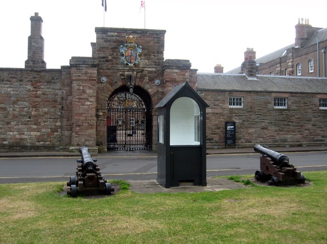
| Gateway and Guard House, Berwick Barracks Museum | 1244721 | I | 1721 | |
| Glen Alva | 1211416 | II | ||
| Grain Store | 1041672 | II | ||
| Grammar School | 1042428 | II* | 1754 | Palace Street East |
| Gravestone of John Mackay Wilson, Churchyard | 1393565 | II | ||
| Ice House | 1396572 | II | 1796 | |
| K6 Telephone Kiosk South of Kings Arms Hotel and Outside Trustee Savings Bank | 1276470 | II | ||
| King's Head Inn | 1290134 | II | ||
| Lady Jerningham Monument in Gardens | 1041699 | II | ||
| Main Street 202-206, Wilson Terrace | 1390638 | II | ||
| Mansergh | 1393893 | II | ||
| Masonic Hall | 1290128 | II | ||
| Military Hospital | 1042446 | II* | Ravensdowne | |
| Mounting Block | 1393671 | II | ||
| Ness Gate Hotel | 1042427 | II | C19th | Palace Street East |
| No. 33, Palace Street | 1393923 | II | ||
| Number 1 and Railings | 1233687 | II | ||
| Number 26 (Incorporating 28) | 1041678 | II | ||
| Number 62 (Incorporating 64) | 1042469 | II | ||
| Numbers 44 and 46 (Harvest House) and 48 | 1211361 | II | ||
| Old Grammar School | 1211251 | II | ||
| Old Hen and Chickens | 1211111 | II | ||
| Our Lady and St Cuthbert's Roman Catholic Church, to Rear of Number 64 | 1270332 | II | Ravensdowne | |
| Pair of Chapels, Lodge, Wall and Gate Piers at Tweedmouth Cemetery | 1393564 | II | ||
| Pair of Smokehouses | 1242923 | II | ||
| Pier and Lighthouse | 1041698 | II | ||
| Pier Maltings | 1391849 | II | ||
| Police Station and Magistrates Court | 1393915 | II | ||
| Post Office | 1290049 | II | ||
| Premises Occupied by the Card Shop, Premises Occupied by the Town House Coffee House and Premises Oc. | 1042466 | I | To the rear of the Town Hall | |
| Quayside Granary | 1233693 | II | ||
| Railway Station | 1042440 | II | 1927 | Rebuilding of mid C19th station. |
| Rampart House | 1396370 | II | ||
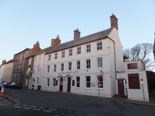
| Ravensholme Hotel | 1370877 | II | C18th | Ravensdowne |
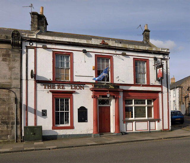
| Red Lion Public House | 1371254 | II* | Castlegate | |
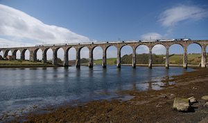
| Royal Border Bridge | 1211052 | I | 1850 | By Robert Stephenson |
| Royal Tweed Bridge | 1393563 | II* | 1928 | |
| Sally Port | 1041668 | II | ||
| Sanson Seal House | 1042479 | II | ||
| Scotsgate | 1370836 | I | ||
| Shore Gate | 1233671 | I | 1760 | |
| Spittal School and Surrounding Walls and Railings | 1390923 | II | ||
| St Cuthbert's Roman Catholic Presbytery | 1211543 | II | Ravensdowne | |
| Stocks, by the Town Hall | 1211152 | II | ||
| The Berwick Arms | 1211331 | II | ||
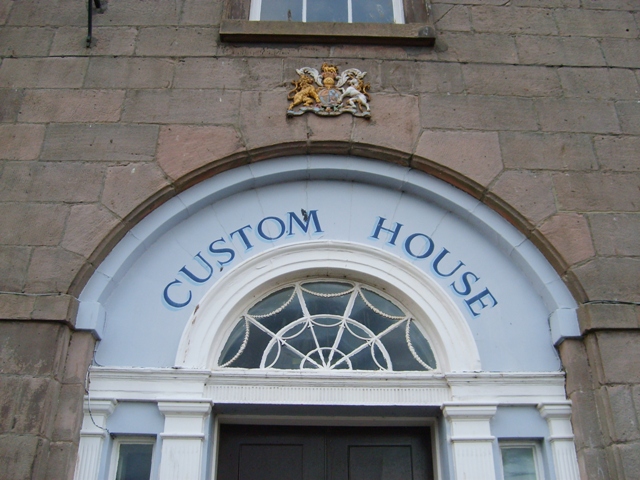
| The Custom House | 1042437 | I | C18th | |
| The Free Trade Inn | 1264036 | II | ||
| The Governor's House | 1370859 | II* | c.1719 | Palace Green |
| The Granary | 1072607 | II | ||
| The Hen and Chickens Hotel | 1233667 | II | C18th | Sandgate |
| The King's Arms Hotel | 1290070 | II | ||
| The Leaping Salmon | 1290205 | II | ||
| The Lions House | 1371224 | II* | C18th | |
| The Magazine, Including Enclosing Wall and Entrance to the Magazine | 1041697 | II* | 1749 | |
| The Old Brewery | 1233813 | II | ||
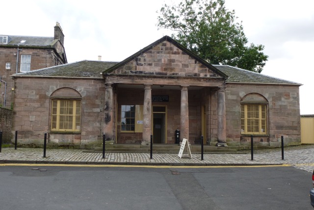
| The Old Guardhouse | 1042425 | II* | C18th | Palace Green. Main Guard. |
| The Old Vicarage | 1042477 | II | ||
| The Queen's Head Hotel | 1233668 | II | ||
| Tower House | 1370856 | II | ||
| Town Fortifications Including the Bell Tower | 1290222 | I | ||
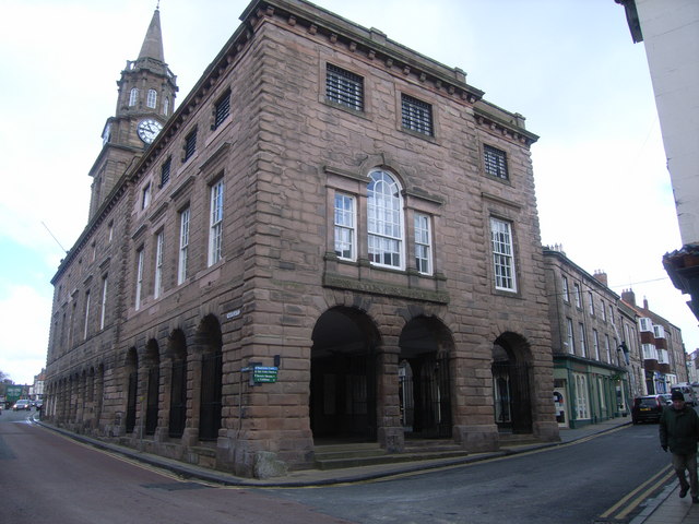
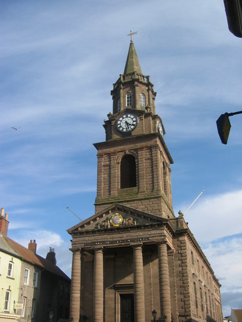
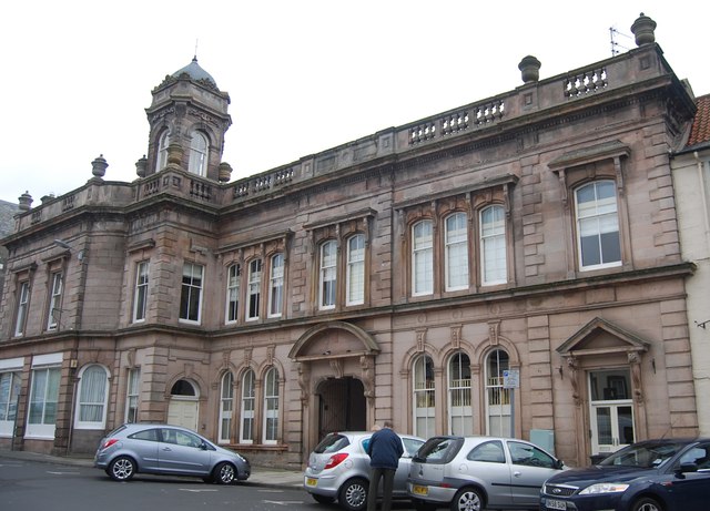
| Town Hall | 1290051 | I | 1754 | |
| United Presbyterian Church | 1371226 | II | ||
| Victoria House | 1211158 | II | ||
| Wall of Berwick Castle to North of the Ruins of Constable Tower | 1041696 | I | ||
| Wallace Green Manse | 1233679 | II* | ||
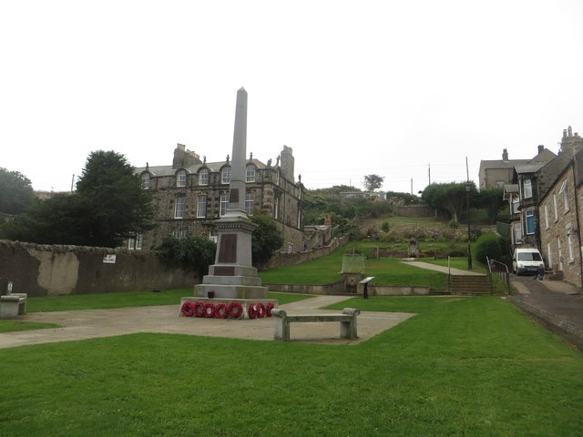
| War Memorial (Berwick) | 1041674 | II | 1923 | Castlegate |
| War Memorial (Tweedmouth) | 1393516 | II | 1920 | |
| War Memorial (Spittal) | 1393638 | II | 1921 | |
| West Barrack and Attached Perimeter Wall, Berwick Barrack Museum | 1244722 | I | 1721 | |
| Spittal Conservation Area | - | n/a | Conservation Area | |
| Berwick-upon-Tweed Conservation Area | - | n/a | Conservation Area | |
| Tweedmouth Conservation Area | - | n/a | Conservation Area |
Primary source: the National Heritage List for England - NHLE is the register of nationally protected historic buildings and sites in England, including listed buildings, scheduled monuments, protected wrecks, registered parks and gardens, and battlefields. The list is maintained by Historic England. Check NHLE for updates and new entries. Secondary sources: British Listed Buildings and Keys to the Past.
Co-Curate Page
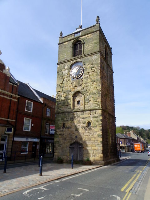
Clock Tower
- Overview About the Clock Tower Map Street View The Clock Tower on Old Gate in Morpeth was built in the early 17th century, using stone from an earlier Medieval building. …
Co-Curate Page
Old Bridge
- Overview Map Street View Berwick Bridge, over the River Tweed at Berwick, was built between 1611 and 1634 by James Burrell. The red sandstone bridge has 15 arches and is …
Co-Curate Page
Berwick Castle (ruins)
- Overview About Berwick Castle Map Street View Berwick Castle is a ruined castle in Berwick-upon-Tweed, Northumberland, England. History The castle was founded in the 12th century by the Scottish …
Co-Curate Page
Church of the Holy Trinity
- Overview Map Street View Grade I listed on the National Heritage List for England.
Co-Curate Page
Building to Rear of Town Hall
- At the junction of Marygate & Church Street. Grade I listed.
Co-Curate Page
Royal Border Bridge
- Railway bridge across the River Tweed designed by Robert Stephenson and built between 1847 and 1850, at its height the workforce numbered 2,700 men. The bridge was officially opened by …

Co-Curate Page
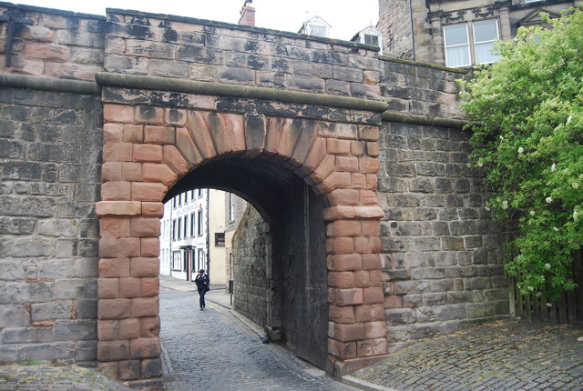
Scotsgate
- Overview Map Street View Scotsgate is part of the defensive Town Walls in Berwick-upon-Tweed. It dates from Elizabethan times, altered in 1815 and again in 1858.[1] Scotsgate, between the streets …
Co-Curate Page
Town Hall
- Overview Map Street View Completed in 1754 and restored 1857-8. The Town Hall is a Grade I listed building.

Co-Curate Page
Battle of Halidon Hill, 1333
- Overview Map of the Battlefield Scottish forces under Sir Archibald Douglas were defeated by the English armies led by Edward III at Halidon Hill, 2 miles from Berwick-upon-Tweed in July …

Co-Curate Page
War Memorial, Berwick
- Overview Map Street View The war memorial is located on Castlegate in Berwick Upon Tweed. Dedicated to 474 local men and women who lost their lives in the First World War, …
Co-Curate Page
Wallace Green Church
- Overview Map Street View St Andrews Church is located on Wallace Green in Berwick upon Tweed. It was built 1858-1859 by J.D, and I. Hay of Liverpool, and it's first …
Co-Curate Page
Church of St Bartholomew and St Boisil
- Overview Map Street View St Bartholomew and St Boisil's is the parish church in Tweedmouth, Berwick-upon-Tweed. A church on this site was recorded in 1145 AD, and there is thought …
Co-Curate Page
The Main Guard
- Overview Map Street View The Main Guard is an old guardhouse, located on Place Green in Berwick-upon-Tweed. The 18th century building comprised of a soldiers’ room, a more comfortable officers’ …
Co-Curate Page
The Magazine
- Overview Map The Magazine is situated by the Town Walls, close to Lions House, in Berwick-upon-Tweed. The building dates from 1749 and is a former gunpowder store for the garrison. The …

Co-Curate Page
The Governor's House
- Overview Map Street View The Governor's House, No. 1 Palace Green, Berwick-upon-Tweed. This was formerly the residence of the Military Governor of the Garrison of Berwick-upon-Tweed. The house was completed …

Co-Curate Page
Boys' National School
- No.5, Ravensdowne in Berwick-upon-Tweed is a former Boys' National School. It was a charity school, established in 1725, and rebuilt and enlarged 1842. The building is Grade II listed on …
Co-Curate Page
Former Corn Exchange, Berwick-upon-Tweed
- Nos.1a and 3, Sandgate in Berwick upon Tweed is the former Corn Exchange, built in 1858. The rear of the building on Foul Ford (street) has dramatic curved wall with …

Co-Curate Page
No 15. Sandgate (former Hen and Chickens Hotel)
- No 15. Sandgate in Berwick upon Tweed dates from the 18th century. It was the Hen and Chickens Hotel for many years. However, the Hotel permanently closed on the 1th …

Co-Curate Page
No 5. Palace Street East
- Overview Map Street View No 5., Palace Street East in Berwick upon Tweed is a large 3 storey house built in 1754. The building became the centre of a Grammar …

Co-Curate Page
Springhill Camp
- Scheduled Monument areas - based on Historic England data (Open Government Licence). This site is located close to Spring Hill, to the south of Tweedmouth in Northumberland. It is scheduled …
Co-Curate Page
Camphill Iron Age Settlement
- On Camp Hill, to the north-west of Berwick-upon-Tweed, are the remains of an Iron Age defended settlement. The site, which is heavily farmed, is a Scheduled Monument (legally protected). Nearby, …

Co-Curate Page
Halidon Hill Iron Age Settlement
- Scheduled Monument areas - based on Historic England data (Open Government Licence). To the north-west of Berwick-upon-Tweed is Halidon Hill; by its summit, on it's south-facing slope is the site …

Co-Curate Page
Clock Tower
- Overview About the Clock Tower Map Street View The Clock Tower on Old Gate in Morpeth was built in the early 17th century, using stone from an earlier Medieval building. …
Co-Curate Page
Old Bridge
- Overview Map Street View Berwick Bridge, over the River Tweed at Berwick, was built between 1611 and 1634 by James Burrell. The red sandstone bridge has 15 arches and is …
Co-Curate Page
Berwick Castle (ruins)
- Overview About Berwick Castle Map Street View Berwick Castle is a ruined castle in Berwick-upon-Tweed, Northumberland, England. History The castle was founded in the 12th century by the Scottish …
Co-Curate Page
Church of the Holy Trinity
- Overview Map Street View Grade I listed on the National Heritage List for England.
Co-Curate Page
Building to Rear of Town Hall
- At the junction of Marygate & Church Street. Grade I listed.
Co-Curate Page
Royal Border Bridge
- Railway bridge across the River Tweed designed by Robert Stephenson and built between 1847 and 1850, at its height the workforce numbered 2,700 men. The bridge was officially opened by …
Co-Curate Page
Scotsgate
- Overview Map Street View Scotsgate is part of the defensive Town Walls in Berwick-upon-Tweed. It dates from Elizabethan times, altered in 1815 and again in 1858.[1] Scotsgate, between the streets …
Co-Curate Page
Town Hall
- Overview Map Street View Completed in 1754 and restored 1857-8. The Town Hall is a Grade I listed building.
Co-Curate Page
Battle of Halidon Hill, 1333
- Overview Map of the Battlefield Scottish forces under Sir Archibald Douglas were defeated by the English armies led by Edward III at Halidon Hill, 2 miles from Berwick-upon-Tweed in July …
Co-Curate Page
War Memorial, Berwick
- Overview Map Street View The war memorial is located on Castlegate in Berwick Upon Tweed. Dedicated to 474 local men and women who lost their lives in the First World War, …
Co-Curate Page
Wallace Green Church
- Overview Map Street View St Andrews Church is located on Wallace Green in Berwick upon Tweed. It was built 1858-1859 by J.D, and I. Hay of Liverpool, and it's first …
Co-Curate Page
Church of St Bartholomew and St Boisil
- Overview Map Street View St Bartholomew and St Boisil's is the parish church in Tweedmouth, Berwick-upon-Tweed. A church on this site was recorded in 1145 AD, and there is thought …
Co-Curate Page
The Main Guard
- Overview Map Street View The Main Guard is an old guardhouse, located on Place Green in Berwick-upon-Tweed. The 18th century building comprised of a soldiers’ room, a more comfortable officers’ …
Co-Curate Page
The Magazine
- Overview Map The Magazine is situated by the Town Walls, close to Lions House, in Berwick-upon-Tweed. The building dates from 1749 and is a former gunpowder store for the garrison. The …
Co-Curate Page
The Governor's House
- Overview Map Street View The Governor's House, No. 1 Palace Green, Berwick-upon-Tweed. This was formerly the residence of the Military Governor of the Garrison of Berwick-upon-Tweed. The house was completed …
Co-Curate Page
Boys' National School
- No.5, Ravensdowne in Berwick-upon-Tweed is a former Boys' National School. It was a charity school, established in 1725, and rebuilt and enlarged 1842. The building is Grade II listed on …
Co-Curate Page
Former Corn Exchange, Berwick-upon-Tweed
- Nos.1a and 3, Sandgate in Berwick upon Tweed is the former Corn Exchange, built in 1858. The rear of the building on Foul Ford (street) has dramatic curved wall with …
Co-Curate Page
No 15. Sandgate (former Hen and Chickens Hotel)
- No 15. Sandgate in Berwick upon Tweed dates from the 18th century. It was the Hen and Chickens Hotel for many years. However, the Hotel permanently closed on the 1th …
Co-Curate Page
No 5. Palace Street East
- Overview Map Street View No 5., Palace Street East in Berwick upon Tweed is a large 3 storey house built in 1754. The building became the centre of a Grammar …
Co-Curate Page
Springhill Camp
- Scheduled Monument areas - based on Historic England data (Open Government Licence). This site is located close to Spring Hill, to the south of Tweedmouth in Northumberland. It is scheduled …
Co-Curate Page
Camphill Iron Age Settlement
- On Camp Hill, to the north-west of Berwick-upon-Tweed, are the remains of an Iron Age defended settlement. The site, which is heavily farmed, is a Scheduled Monument (legally protected). Nearby, …


