Topics > Northumberland > Civil Parishes in Northumberland > Alwinton Civil Parish > Historic Buildings and Monuments in Alwinton Civil Parish
Historic Buildings and Monuments in Alwinton Civil Parish
Listed buildings and scheduled monuments in Alwinton Civil Parish, Northumberland, from the National Heritage List for England[1]. Use the Search (below) if looking for a specific building / monument.
| Structure | List No. | Grade | Built~ | Notes |
|---|---|---|---|---|
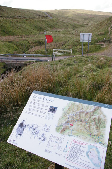
| Chew Green, Roman Fort | 1015847 | n/a | Roman | Scheduled Monument |
| Alwinton Farmhouse | 1371430 | II | ||
| Cartshed and Byre Circa 10 Yards North of Alwinton House | 1041295 | II | ||
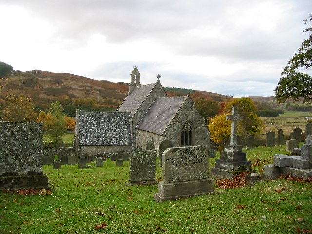
| Church of St Michael and All Saints | 1041296 | II* | C12th | Low Alwinton. Largely rebuilt 1851 |
| Church Stable and Wall Circa 5 Yards West of Church of St Michael | 1371431 | II | ||
| Clennel Hall | 1155405 | II | ||
| Dickson Headstone Circa 5 Yards West of Church of St Michael | 1041299 | II | ||
| Feil Gravestone Circa 10 Yards South of Chancel of Church of St Michael | 1155329 | II | ||
| Keeper's Cottages | 1041307 | II | ||
| Pair of Turnbull Headstones Circa 20 Yards South of Chancel of Church of St Michael | 1371432 | II | ||
| Robson and Brown Headstones Circa 15 Yards South of Church of St Michael | 1041298 | II | ||
| Shilmoor Farmhouse | 1303389 | II | ||
| Stable, Granary and Pigsty Circa 20 Yards East of Shilmoor Farmhouse | 1041302 | II | ||
| Table Tomb Circa 3 Yards South of South Door of Church of St Mochael | 1303382 | II | ||
| Wallace Headstone 15 Yards South-West of Church of St Michael | 1041300 | II | ||
| Weallans Gravestone 3 Yards South East of South Transept of Church of St Michael | 1041297 | II | ||
| Iron Age defended settlement and later Romano-British settlement on Gallow Law, 600m north of Alwinton Farm | 1008271 | n/a | Scheduled Monument | |
| Memmerkirk Chapel | 1006489 | n/a | Scheduled Monument | |
| Three cross dykes on Middle Hill | 1007525 | n/a | Scheduled Monument | |
| Iron Age and Romano-British settlements on Ward Law | 1008840 | n/a | Scheduled Monument | |
| Romano-British farmstead, 700m north east of Trows | 1008841 | n/a | Scheduled Monument | |
| Palisaded settlement on Trows Law | 1008842 | n/a | Scheduled Monument | |
| Roman camp, 900m NNE of Featherwood | 1008881 | n/a | Scheduled Monument | |
| Three round cairns on Thirl Moor | 1008883 | n/a | Scheduled Monument | |
| Green Gairs round cairn | 1008985 | n/a | Scheduled Monument | |
| Round cairn, 160m north east of Hosedon Linn | 1009679 | n/a | Scheduled Monument | |
| Round cairn 420m north-east of Blindburn Bridge | 1008266 | n/a | Scheduled Monument | |
| Unenclosed round house, 200m north of Barrow Cleugh | 1008267 | n/a | Scheduled Monument | |
| Clennell Street palisaded settlement | 1008272 | n/a | Scheduled Monument | |
| Palisaded settlement, 200m NNE of Hosedon Linn | 1008273 | n/a | Scheduled Monument | |
| Round cairn on Shillhope Law | 1008434 | n/a | Scheduled Monument | |
| Round cairn, 650m ESE of Old Quickening Cote | 1008435 | n/a | Scheduled Monument | |
| Crigdon Hill round cairn | 1008567 | n/a | Scheduled Monument | |
| Deserted medieval village 320m west of Quickening Cote | 1011416 | n/a | Scheduled Monument | |
| Russell's Cairn on Windy Gyle | 1015318 | n/a | Scheduled Monument | |
| Round cairn west of Windy Gyle, 680m WNW of Russell's Cairn | 1015319 | n/a | Scheduled Monument | |
| Linbrig deserted medieval village, 540m north of Linbriggs | 1015524 | n/a | Scheduled Monument | |
| Passpeth Sike deserted medieval hamlet, 1.2km east of Shillmoor | 1015851 | n/a | Scheduled Monument | |
| Medieval and later dispersed settlement, 730m north and 860m north of Linbriggs | 1016471 | n/a | Scheduled Monument | |
| Ring cairn and round cairn on Turf Hill | 1017725 | n/a | Scheduled Monument | |
| Ring cairn 240m north east of Old Quickening Cote | 1017726 | n/a | Scheduled Monument | |
| Cross dyke and two building foundations at Copper Snout | 1017736 | n/a | Scheduled Monument | |
| Two deserted medieval hamlets and part of an associated field system, 830m east of Shillmoor | 1017759 | n/a | Scheduled Monument | |
| Observation post 140m north west of Ridlees Cairn | 1021028 | n/a | Scheduled Monument | |
| Observation post 780m north west of Blackburn Crag | 1021029 | n/a | Scheduled Monument | |
| Observation post immediately north of Watty Bell's Cairn | 1021036 | n/a | Scheduled Monument | |
| Observation post 690m east of Watty Bell's Cairn | 1021037 | n/a | Scheduled Monument | |
| Round cairn 960m ENE of West Wilkwood | 1018940 | n/a | Scheduled Monument | |
| Unenclosed hut circle settlement and plot of cord rig, 650m south west of Wholehope | 1018941 | n/a | Scheduled Monument | |
| Two round cairns 880m north east of Wilkwood East | 1018949 | n/a | Scheduled Monument | |
| Romano-British settlement 810m south of Slippery Crags | 1019397 | n/a | Scheduled Monument | |
| Roman camp, 1.05km north of Featherwood | 1008882 | n/a | Scheduled Monument | |
| Cross dyke, 200m south east of Hosedon Linn | 1008274 | n/a | Scheduled Monument | |
| Cross dyke south east of Uplaw Knowe | 1008275 | n/a | Scheduled Monument | |
| Romano-British farmstead, 275m north-east of Hosedon Linn | 1008279 | n/a | Scheduled Monument | |
| Outer Golden Pot medieval wayside cross | 1008282 | n/a | Scheduled Monument | |
| Ridlees round cairn, 640m north east of Hanging Crag | 1008433 | n/a | Scheduled Monument | |
| Defended settlement, field system, cairnfield, round cairn and medieval settlement, 300m south east of Barrow | 1018937 | n/a | Scheduled Monument | |
| Watty Bell's round cairn | 1015839 | n/a | Scheduled Monument |
Primary source: the National Heritage List for England - NHLE is the register of nationally protected historic buildings and sites in England, including listed buildings, scheduled monuments, protected wrecks, registered parks and gardens, and battlefields. The list is maintained by Historic England. Check NHLE for updates and new entries.
Secondary sources: British Listed Buildings and Keys to the Past.
Co-Curate Page
Church of St Michael's and all Angels
- Overview Map Street View Inside St Michael's and all Angels Church in Alwinton dates from the 12th Century, though much of it was rebuilt in 1851. The Church is Grade …
Co-Curate Page
Chew Green, Roman Fort
- Overview About Chew Green Map & Aerial View Chew Green is the site of a large Roman encampment located about 9 miles west of Alwinton in Northumberland, and very close …

Co-Curate Page
Church of St Michael's and all Angels
- Overview Map Street View Inside St Michael's and all Angels Church in Alwinton dates from the 12th Century, though much of it was rebuilt in 1851. The Church is Grade …


