Topics > Northumberland > Civil Parishes in Northumberland > Whitton and Tosson Civil Parish > Historic Buildings and Monuments in Whitton and Tosson CP
Historic Buildings and Monuments in Whitton and Tosson CP
Listed buildings and scheduled monuments in Whitton and Tosson Civil Parish, Northumberland, from the National Heritage List for England[1]. Use the Search (below) if looking for a specific building / monument.
| Structure | List No. | Grade | Built~ | Notes |
|---|---|---|---|---|
| Boundary Stone Circa 300 Yards North East of Simonside Summit | 1155441 | II | ||
| East Newtown Farmhouse | 1042063 | II | ||
| Garden Wall in Front of Whitton Farmhouse | 1042064 | II | ||
| Gates, Gatepiers and Garden Walls South of Whitton Grange | 1042065 | II | ||
| Gazebo Circa 20 Yards North of Whitton Grange | 1303326 | II | ||
| Pant Circa 15 Yards North East of Allerdene | 1303353 | II | C18th | Allerdene |
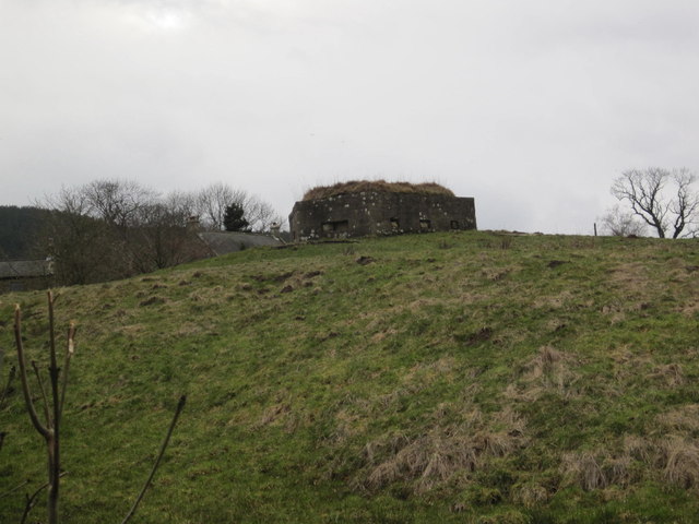
| Pill Box at Nu 005 015 | 1232569 | II | ||
| Pill Box at Nu 019 018 | 1277014 | II | ||
| Pill Box at Nu 035 012 | 1277015 | II | Near Newtown | |
| Pill Box at Nu 045 010 | 1232571 | II | ||
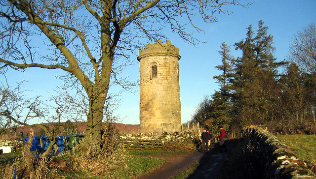
| Sharpe's Folly | 1155472 | II* | c.1720 | Whitton |
| Terrace Wall Circa 20 Yards West of Whitton Grange | 1371029 | II | ||
| Tosson Tower | 1371067 | II* | C14th | Ruined medieval tower house |
| Tosson Tower Farmhouse | 1303355 | II | ||
| Wall, Arbour and Base of Tower Attached to South of Whitton Grange | 1042066 | II | ||
| Whitton Cottage | 1155453 | II | ||
| Whitton Farmhouse | 1155452 | II | ||
| Whitton Pant Circa 40 Yards North of Whitton Tower | 1155465 | II | ||
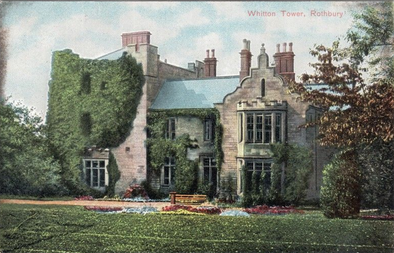
| Whitton Tower | 1371030 | II* | C14th | |
| Great Tosson tower house | 1008096 | n/a | Scheduled Monument | |
| Tosson Burgh univallate hillfort, 450m west of Great Tosson | 1011267 | n/a | Iron Age | Scheduled Monument |
| Cairn 670m south of Great Tosson | 1011606 | n/a | Scheduled Monument | |
| Romano-British farmstead, 175m south of Cockpit Well | 1009582 | n/a | Scheduled Monument | |
| Cupmarked stone, 690m south-west of Wagtail Farm | 1011288 | n/a | Scheduled Monument | |
| Cup and ring marked rock, 940m south-west of Wagtail Farm | 1011289 | n/a | Scheduled Monument | |
| Standing stone, 810m north-east of Whittondean Farm | 1011290 | n/a | Scheduled Monument | |
| Cup and ring marked rock and adjacent stone setting, 820m east of Whittondean Farm | 1011293 | n/a | Scheduled Monument | |
| Lordenshaw multivallate hillfort, Romano-British settlements, field system, cairnfield, cross dyke, round cairn cemetery, rock art and medieval park pale | 1017196 | n/a | Scheduled Monument | |
| Cairn 570m east-north-east of Wittondean Farm | 1008699 | n/a | Scheduled Monument | |
| Medieval monastic sheep farm (bercaria), 550m north-east of Whittondean Farm | 1011292 | n/a | Scheduled Monument | |
| Simonside Cairn 670m west-north-west of Old Stell Crag | 1011605 | n/a | Scheduled Monument | |
| Cairn 1km west-north-west of Old Stell Crag | 1011615 | n/a | Scheduled Monument | |
| Two round cairns 590m and 610m east of Burn Brae | 1017197 | n/a | Scheduled Monument | |
| Cairn 320m WNW of Old Stell Crag | 1009356 | n/a | Scheduled Monument | |
| Whitton Conservation Area | - | n/a | Conservation Area |
Primary source: the National Heritage List for England - NHLE is the register of nationally protected historic buildings and sites in England, including listed buildings, scheduled monuments, protected wrecks, registered parks and gardens, and battlefields. The list is maintained by Historic England. Check NHLE for updates and new entries. Secondary sources: British Listed Buildings and Keys to the Past.
Co-Curate Page
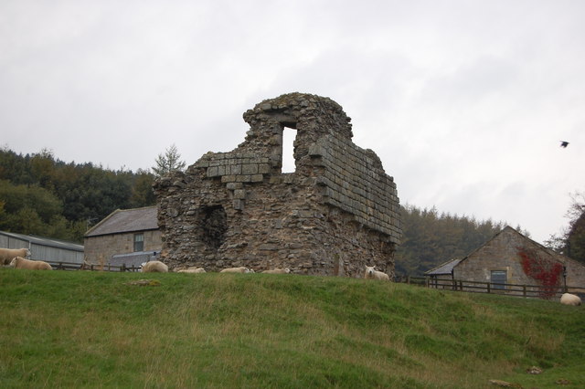
Tosson Tower
- Overview Map Street View Tosson Tower is a ruined medieval tower house located in Great Tosson. It was the home of the Ogle family, who obtained lands at Tosson in …
Co-Curate Page
Sharpe's Folly, Whitton
- Overview Map Street View Built in the c.1720's, Sharpe's Folly in Whitton is probably the earliest folly in the county.[1] a plaque on the building states: "SHARP'S FOLLY / errected …
Co-Curate Page
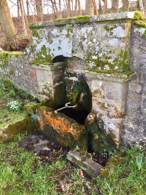
Allerdene Pant
- Overview Map Street View At Allerdene is a pant (water fountain) with a lion's head spout and stone trough. The pant dates from the late 18th or early 19th century, …

Co-Curate Page
Tosson Burgh univallate hillfort
- Scheduled Monument area - based on Historic England data (Open Government Licence) - to the west of Great Tosson. LIDAR - Image from opendata.hillforts.eu (CC-BY-SA), based on data from the …

Co-Curate Page
Tosson Tower
- Overview Map Street View Tosson Tower is a ruined medieval tower house located in Great Tosson. It was the home of the Ogle family, who obtained lands at Tosson in …
Co-Curate Page
Sharpe's Folly, Whitton
- Overview Map Street View Built in the c.1720's, Sharpe's Folly in Whitton is probably the earliest folly in the county.[1] a plaque on the building states: "SHARP'S FOLLY / errected …
Co-Curate Page
Allerdene Pant
- Overview Map Street View At Allerdene is a pant (water fountain) with a lion's head spout and stone trough. The pant dates from the late 18th or early 19th century, …


