Topics > Northumberland > Civil Parishes in Northumberland > Rothbury Civil Parish > Historic Buildings and Monuments in Rothbury
Historic Buildings and Monuments in Rothbury
This page includes listed buildings and scheduled monuments in Rothbury Civil Parish, Northumberland, from the National Heritage List for England[1]. As well as town of Rothbury, the parish also includes the Cragside estate, the histories of these are closely intertwined. Use the Search (below) if looking for a specific building / monument.
| Structure | List No. | Grade | Built~ | Note |
|---|---|---|---|---|
| Cragside (Gardens, pleasure grounds, parkland) | 1001046 | I | 1863 |
Listed Park and Garden. Parts in Rothbury, & Brinkburn parishes. |
| Nos. 1 and 2, Church Street | 1031334 | II | C19th | |
| No. 1, Market Place | 1371124 | II | C19th | |
| No. 2, Market Place | 1203289 | II | C18th | |
| No. 4, Market Place | 1281762 | II | C19th | |
| No. 5, Market Place | 1041948 | II | C18th | |
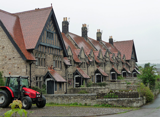
| Addycombe Cottages | 1371116 | II | 1873 | 13-19, Addycombe Gardens |
| Addycombe Cottages with Attached Walls and Outbuildings | 1041930 | II* | 1873 | 1-12, Addycombe Gardens |
| Alexandra House | 1041941 | II | C18th | High Street |
| Armstrong Cottages | 1281765 | II | 1896 | Almshouses built by Lord Armstrong |
| Bell Headstone 21 Metres South East of Porch of Church of All Saints | 1041935 | II | 1743 | |
| Bridge House | 1371118 | II | c.1790 | |
| Bridge Street House | 1041934 | II | C19th | |
| Bridge Way | 1041933 | II | C18th | |
| Chimney on Hilltop West of B6341, 420 Metres North West of Cragside Park House | 1041940 | II | C19th | |
| Chimney on West Side of B6341, 100 Metres North North West of Cragside Park House | 1371122 | II | C19th | |
| Church of All Saints | 1371119 | II* | C13th | |
| Clock Tower 110 Metres North East of Cragside Park House | 1354750 | II* | 1864 | Cragside |
| Conservatory and Stables to North East of Cragside Park House | 1371121 | II | C19th | |
| Conway House (Premises of Rg Bolam and Son) | 1041942 | II | 1876 | |
| Cragside Park House | 1041937 | II | 1864 | Cragside |
| Doctors Surgery | 1041947 | II | C18th | 3, Market Place |
| Eleanor Headstone 17 Metres South of Porch of Church of All Saints | 1031330 | II | 1755 | |
| Farley House | 1281752 | II | 1722 | |
| Fernery to North East of Conservatory | 1041938 | II | 1722 | |
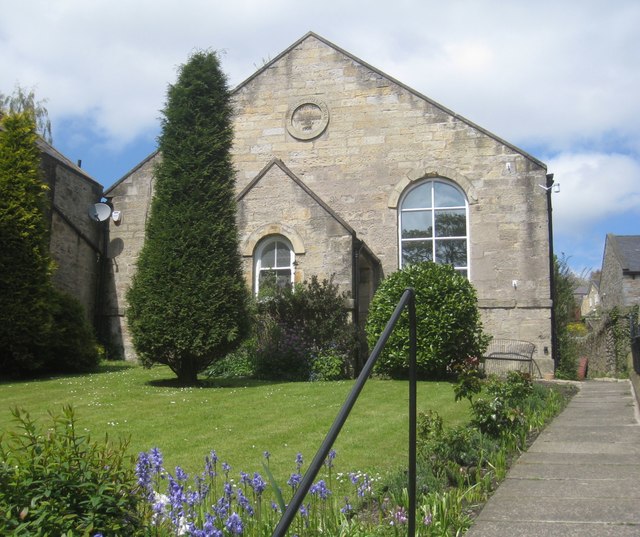
| Former Congregational Church, Now Church Hall | 1203271 | II | 1842 | |
| Front Wall and Gateway to Armstrong Cottages | 1371125 | II | 1896 | |
| Highfield and Adjacent Cottage to East | 1041946 | II | C18th | |
| House Belonging to Mrs Armstrong | 1041943 | II | C18th | Pair of houses, formerly the Sun Inn |
| Knocklaw and Adjacent Cottage to East | 1371117 | II | C18th | |
| Lloyds Bank | 1355025 | II | c.1900 | High Street |
| Monument to First Lord Armstrong at South West of Detached Graveyard | 1371120 | II | 1900 | |
| Monument to Walter Mavin at South East of Detached Graveyard | 1041936 | II | 1900 | |
| Ogle House | 1041944 | II | C18th | High Street |
| Orchard Guest House | 1041945 | II | c.1800 | High Street |
| Outbuilding Range to North of Westhills Farmhouse | 1371142 | II | C18th | |
| Pant 10 Metres West of Clock Tower | 1041939 | II | C19th | Cragside |
| Pill Box at NU059015 | 1052196 | II | 1940 | |
| Premises Occupied by WG Mackay Limited | 1371123 | II | 1841 | Haw Hill. Former school. |
| Premises of T Rogerson and Sons | 1025302 | II | C18th | High Street |
| Purvis Headstone 16 Metres East of Church of All Saints | 1376898 | II | 1786 | |
| Roadside Wall to West and North of Cragside Park House | 1025308 | II | C19th | |
| Rose Arbour and Terrace Wall to East of Cragside Park House | 1354738 | II | C19th | |
| Rothbury Bridge | 1041932 | II | 1460 | Extensive repairs following flood damage in 2012. Scheduled Monument (1006575) |
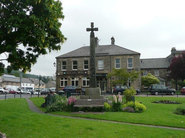
| Rothbury Cross | 1025321 | II | 1902 | |
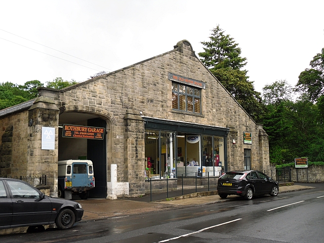
| Rothbury Motors Garage | 1041949 | II | 1913 | Now the Old Motor House. |
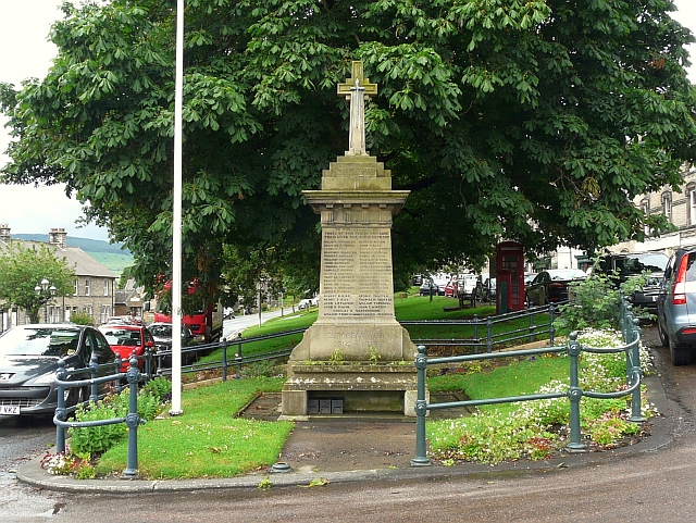
| Rothbury War Memorial | 1408998 | II | 1921 | |
| Shelter Sheds and Granary 80 Metres North East of Westhills Farmhouse | 1281744 | II | C18th | |
| Stone bridge, across the Debdon Burn 220 metres south-west of Cragside | 1371052 | II | C19th | Cragside |
| Sunshine Recorder to South East of Conservatory at Cragside Park House | 1025879 | II | C19th | |
| The Iron Bridge Across the Debdon Burn 80 Metres North West of Cragside | 1042033 | II* | 1870s | Cragside |
| The Old Mill with Attached Wall to North West (Thrum Mill) | 1041931 | II | C18th | Watermill, restored 2013. |
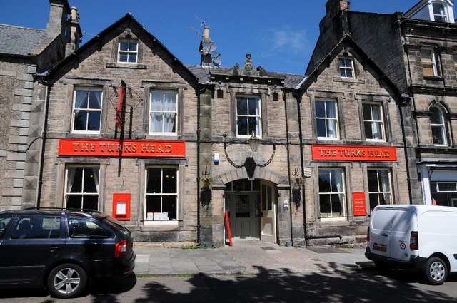
| Turks Head Inn | 1203235 | II | C18th | Largely rebuilt in 1874 after fire |
| West End House | 1203255 | II | C18th | High Street |
| Cairn 900m north-east of Old Rothbury hillfort | 1008757 | n/a | Bronze Age | Scheduled Monument |
| Standing stone 550m north-east of Old Rothbury hillfort | 1008698 | n/a | Late Neolithic | Scheduled Monument |
| Old Rothbury multivallate hillfort and cairnfield | 1011616 | n/a | Prehistoric | Scheduled Monument |
| Cairn 210m north-east of Westhills Farm | 1011286 | n/a | Bronze Age | Scheduled Monument |
| West Hills multivallate hillfort | 1011291 | n/a | Iron Age | Scheduled Monument |
| Cragside (house) | 1042076 | I | 1864 | Now a National Trust property. |
| Debdon Sawmill and Attached Wall to South West | 1371031 | II* | ||
| Hydraulic Silo Building 70 Metres East of Cragend Farmhouse | 1153196 | II* | ||
| Burnfoot Power House, 70 Metres North of Burnfoot Lodge | 1042071 | II* | ||
| Boundary Stone on North of Debdon Track 210 Metres from Road | 1042069 | II | ||
| Cragside Visitor Centre | 1042034 | II | 1864 | Former stables |
| Tumbleton Boat House | 1371053 | II | C19th | |
| Tumbleton Ram House on West of Debdon Burn at Foot of Tumbelton Dam | 1042035 | II | 1866 | Pumphouse on the Cragside estate |
| Boundary Stone 350 Metres East of Sheepfold by Forster's Shaw Sike | 1042040 | II | ||
| Marker Stone 90 Metres South of Bridge over Debdon Burn | 1042067 | II | ||
| Boundary Stone on North of Debdon Track 80 Metres from Road | 1042068 | II | ||
| Stone on North Side of Old Road, 30 Meres North East of Present Bridge over Whitton Burn | 1042070 | II | ||
| Boundary Stone 250 Metres West of Sheepfold by Forster's Shaw Sike | 1153330 | II | ||
| Pair of Stones on Cartington/Longframlington Boundary | 1155070 | II | ||
| Unenclosed stone hut circle settlement, cairn fields and a rectangular enclosure 1km south-west of Debdon Whitefield | 1011633 | n/a | Scheduled Monument | |
| Cairn 500m west of Debdon Farm | 1011632 | n/a | Scheduled Monument | |
| Cairnfield, standing stone and cup marked rock on Debdon Moor 500m south-west of Primrose Cottage | 1011634 | n/a | Scheduled Monument | |
| Camp 1/2 mile (800m) SE of Wagtail Farm | 1002909 | n/a | Scheduled Monument | |
| Cupmarked stone, 690m south-west of Wagtail Farm | 1011288 | n/a | Scheduled Monument | |
| Cairn 600m west-south-west of Debdon Farm | 1008696 | n/a | Scheduled Monument | |
| Cairnfield on Whitefield Edge, 900m south-west of Debdon Whitefield | 1008879 | n/a | Scheduled Monument | |
| Cup and ring marked rock, 940m south-west of Wagtail Farm | 1011289 | n/a | Scheduled Monument | |
| Rothbury Conservation Area | - | n/a | - | Conservation Area |
| Camp 1/2 mile (800m) SE of Wagtail Farm | 1002909 | n/a | Iron Age | Scheduled Mo |
Primary source: the National Heritage List for England - NHLE is the register of nationally protected historic buildings and sites in England, including listed buildings, scheduled monuments, protected wrecks, registered parks and gardens, and battlefields. The list is maintained by Historic England. Check NHLE for updates and new entries. Secondary sources: British Listed Buildings and Keys to the Past.
Co-Curate Page
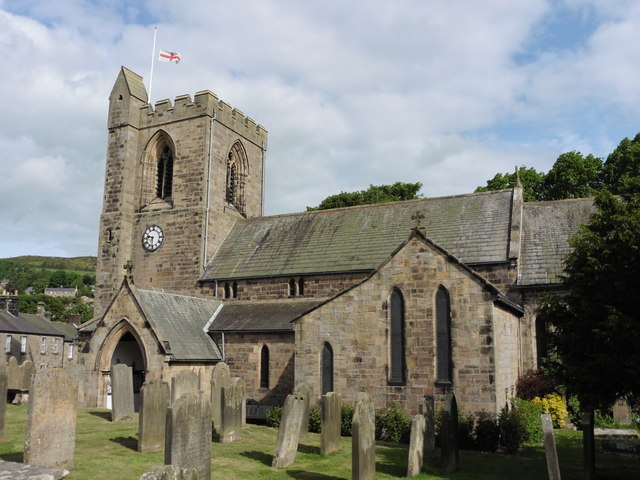
Church of All Saints
- Overview Map Street View Inside All Saints is the parish church of Rothbury. The current church building dates from the 13th century, with restoration in 1850. However, it is a …
Co-Curate Page
Rothbury War Memorial
- Overview Map Street View The War Memorial and drinking fountain on Front Street in Rothbury was unveiled on the 23rd January 1921[1] by William Watson-Armstrong, 2nd Lord Armstrong (1892–1972). The …
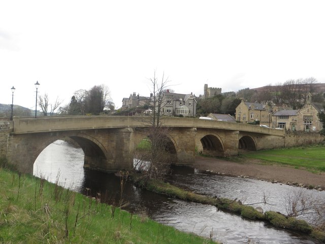
Co-Curate Page
Rothbury Bridge
- Overview Map The road bridge over the River Coquet at Rothbury was originally built in 1460. The bridge is Grade II listed on the National Heritage List for England. The …
Co-Curate Page
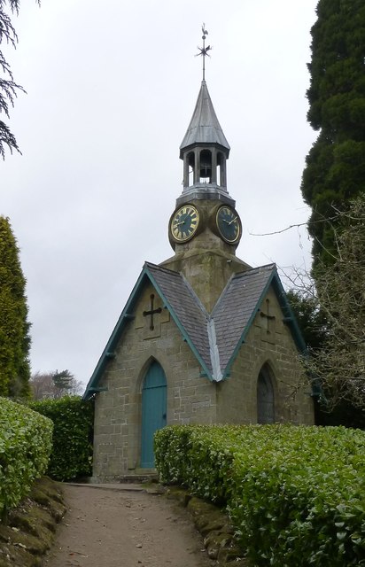
Clock Tower
- The clock tower of 1864 was the original pay office for the Cragside Estate. The clock mechanism is thought to have been designed by Lord Armstrong himself.[1] The clock tower …

Co-Curate Page
Iron Bridge
- The iron footbridge over Debdon Burn at Cragside was manufactured in 1870s at Lord Armstrong's Elswick Works. The footbridge is Grade II* listed on the National Heritage List for England.[1] …
Co-Curate Page
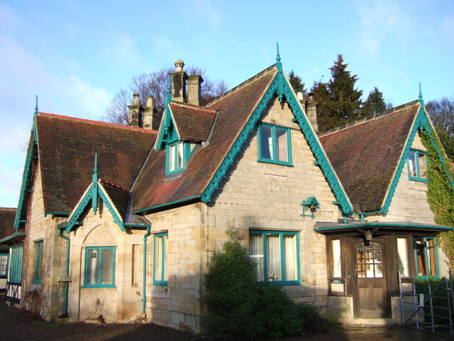
Armstrong Cottages
- Overview Map Street View Twelve almshouses, located off Town Foot in Rothbury, dated 1896. With a plaque inscribed "Erected by WILLIAM GEORGE BARON ARMSTRONG of Cragside in Memory of ANNE …
Co-Curate Page
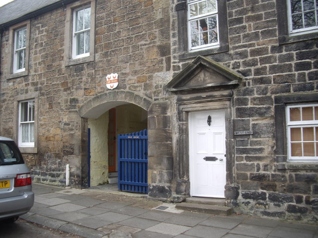
The Turks Head
- Overview Map Street View The Turks Head is located on the High Street in Rothbury. It was built in the c.17th century as a coaching inn. Parts of the inn …
Co-Curate Page
Old Motor House (Rothbury Garage)
- Overview Map Street View Rothbury Garage (now 'The Old Motor House') is located on Town Foot in Rothbury. It is a rare surviving, and relatively unaltered, pre-First World War garage. …
Co-Curate Page
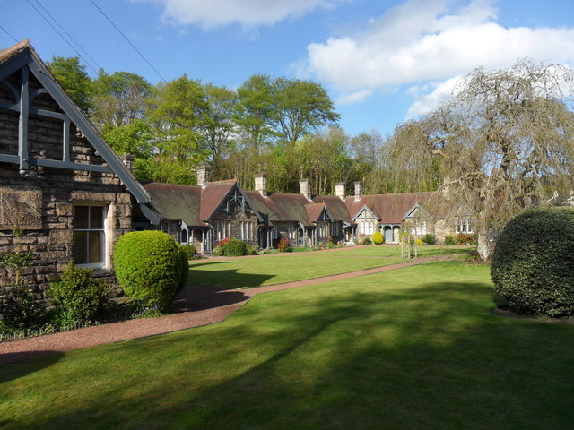
Addycombe Cottages
- Overview Map Street View Addycombe Cottages are located on Addycombe Gardens in Rothbury. The houses were built in 1873 by Norman Shaw for Lord Armstrong. They were built as cottages …
Co-Curate Page
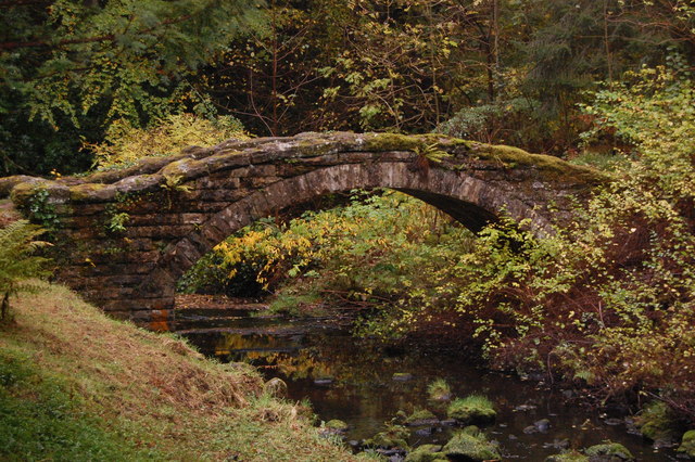
Stone Footbridge over Debdon Burn
- This stone humped bridge crosses the Debdon Burn on the Cragside estate, south of the Iron Bridge. It was built in the late 19th century for Lord Armstrong. It is …
Co-Curate Page
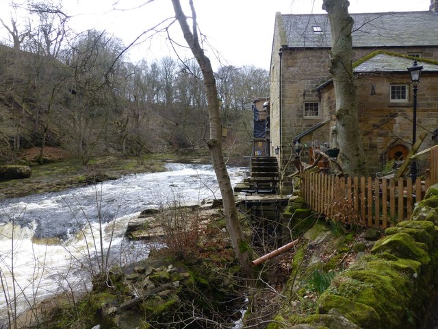
Thrum Mill
- Overview Map Thrum Mill is a hamlet on the north banks of the River Coquet, just west of Rothbury. The water mill here dates from the 18th century, probably on …
Co-Curate Page
Ogle House, Rothbury
- Overview Map Street View Ogle House on the High Street in Rothbury dates from the early 18th century. The house is of 2 storeys with 4 bays and a segmental …
Co-Curate Page
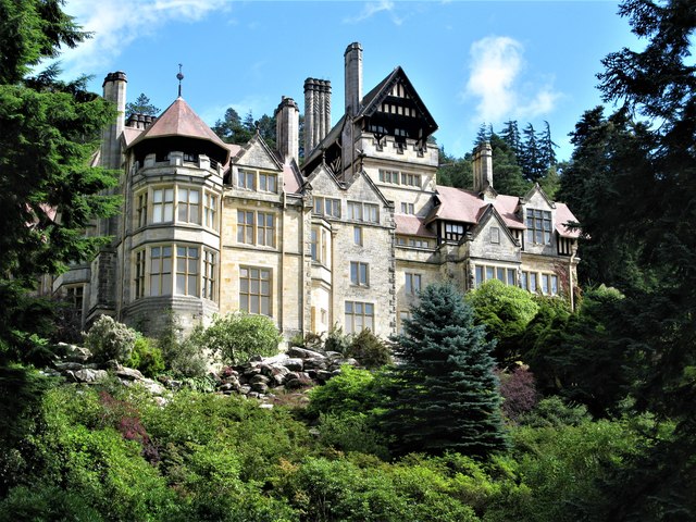
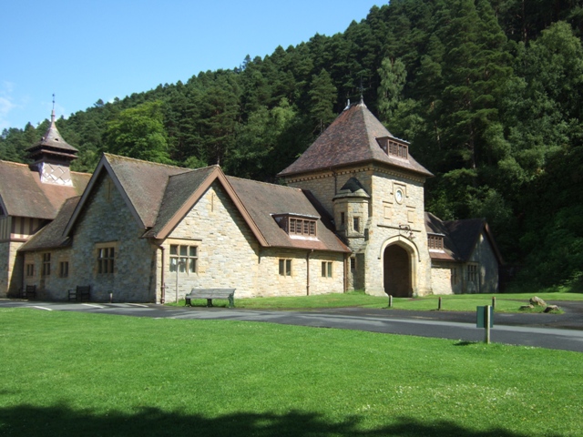
Cragside
- Overview About Cragside Map Street View Cragside was the country house and estate of industrialist Lord William Armstrong and Lady Margaret Armstrong. It was the first house in the world …
Co-Curate Page
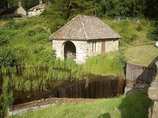
Tumbleton Boat House
- Overview Map Street View The Boat House by Tumbleton Lake at Cragside was built in the mid 19th century, for Lord Armstrong. The boat house is Grade II listed on …
Co-Curate Page
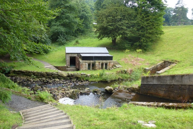
Pumphouse by Tumbleton Dam
- The hydraulic ram pumped water up to a reservoir above Cragside House, which provided its domestic water supply and powered the main lift and turbines operating kitchen and laundry equipment.[1]

Co-Curate Page
Bivallate Defended Settlement WNW of Craghead
- Scheduled Monument area - based on Historic England data (Open Government Licence). The site of this bivallate (two line of ramparts) hillfort, located to the south-east of Wagtail Farm, about …

Co-Curate Page
Church of All Saints
- Overview Map Street View Inside All Saints is the parish church of Rothbury. The current church building dates from the 13th century, with restoration in 1850. However, it is a …
Co-Curate Page
Rothbury War Memorial
- Overview Map Street View The War Memorial and drinking fountain on Front Street in Rothbury was unveiled on the 23rd January 1921[1] by William Watson-Armstrong, 2nd Lord Armstrong (1892–1972). The …
Co-Curate Page
Rothbury Bridge
- Overview Map The road bridge over the River Coquet at Rothbury was originally built in 1460. The bridge is Grade II listed on the National Heritage List for England. The …
Co-Curate Page
Clock Tower
- The clock tower of 1864 was the original pay office for the Cragside Estate. The clock mechanism is thought to have been designed by Lord Armstrong himself.[1] The clock tower …
Co-Curate Page
Iron Bridge
- The iron footbridge over Debdon Burn at Cragside was manufactured in 1870s at Lord Armstrong's Elswick Works. The footbridge is Grade II* listed on the National Heritage List for England.[1] …
Co-Curate Page
Armstrong Cottages
- Overview Map Street View Twelve almshouses, located off Town Foot in Rothbury, dated 1896. With a plaque inscribed "Erected by WILLIAM GEORGE BARON ARMSTRONG of Cragside in Memory of ANNE …
Co-Curate Page
The Turks Head
- Overview Map Street View The Turks Head is located on the High Street in Rothbury. It was built in the c.17th century as a coaching inn. Parts of the inn …
Co-Curate Page
Old Motor House (Rothbury Garage)
- Overview Map Street View Rothbury Garage (now 'The Old Motor House') is located on Town Foot in Rothbury. It is a rare surviving, and relatively unaltered, pre-First World War garage. …
Co-Curate Page
Addycombe Cottages
- Overview Map Street View Addycombe Cottages are located on Addycombe Gardens in Rothbury. The houses were built in 1873 by Norman Shaw for Lord Armstrong. They were built as cottages …
Co-Curate Page
Stone Footbridge over Debdon Burn
- This stone humped bridge crosses the Debdon Burn on the Cragside estate, south of the Iron Bridge. It was built in the late 19th century for Lord Armstrong. It is …
Co-Curate Page
Thrum Mill
- Overview Map Thrum Mill is a hamlet on the north banks of the River Coquet, just west of Rothbury. The water mill here dates from the 18th century, probably on …
Co-Curate Page
Ogle House, Rothbury
- Overview Map Street View Ogle House on the High Street in Rothbury dates from the early 18th century. The house is of 2 storeys with 4 bays and a segmental …
Co-Curate Page
Cragside
- Overview About Cragside Map Street View Cragside was the country house and estate of industrialist Lord William Armstrong and Lady Margaret Armstrong. It was the first house in the world …
Co-Curate Page
Tumbleton Boat House
- Overview Map Street View The Boat House by Tumbleton Lake at Cragside was built in the mid 19th century, for Lord Armstrong. The boat house is Grade II listed on …
Co-Curate Page
Pumphouse by Tumbleton Dam
- The hydraulic ram pumped water up to a reservoir above Cragside House, which provided its domestic water supply and powered the main lift and turbines operating kitchen and laundry equipment.[1]


