Topics > Northumberland > Civil Parishes in Northumberland > Kirknewton Civil Parish > Historic Buildings and Monuments in Kirknewton Civil Parish
Historic Buildings and Monuments in Kirknewton Civil Parish
Listed buildings and scheduled monuments in Kirknewton Civil Parish, Northumberland, from the National Heritage List for England[1]. In the absence of a published 'local list', some other public buildings of interest may also be included. Use the Search (below) if looking for a specific building / monument.
| Structure | List No. | Grade | Built~ | Notes |
|---|---|---|---|---|
| Blaikie Gravestone Circa 20 Yards South South East of Church of St Gregory | 1304186 | II | ||
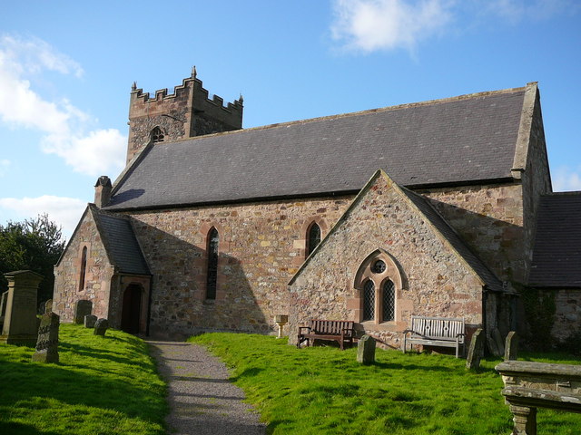
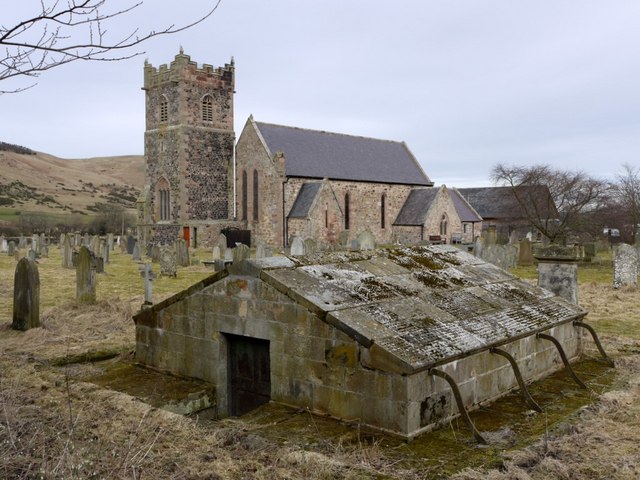
| Church of St Gregory the Great | 1153604 | II* | C12th | Restored 1860 by John Dobson. |
| Davison Grave Circa 9 Yards South of Church of St Gregory | 1370915 | II | ||
| Davison Gravestone Circa 7 Yards South of Church of St Gregory | 1042325 | II | ||
| Davison Mausoleum Circa 40 Yards South West of Church of St Gregory | 1153650 | II | C18th | St Gregorys churchyard. |
| Dawes(?) Gravestone Circa 5 Yards South of Nave of Church of St Gregory | 1153671 | II | ||
| Farmbuildings Circa 100 Yards South of Westnewton House | 1153792 | II | ||
| Garage Circa 70 Yards South West of Westnewton House | 1042328 | II | ||
| Gingang Barn and Shelter Sheds at East Kirknewton Farm | 1370916 | II | ||
| Gravestone Circa 30 Yards South East of Church of St Gregory | 1304176 | II | ||
| Gravestone Circa 35 Yards South of Church of St Gregory | 1042323 | II | ||
| Gravestone of Josephine Butler Circa 5 Yards West of Church of St Gregory | 1370914 | II | ||
| Gravestone of William...(?) Circa 18 Yards South South East of Church of St Gregory | 1042324 | II | ||
| Hethpool Cottages | 1370912 | II | 1926 | |
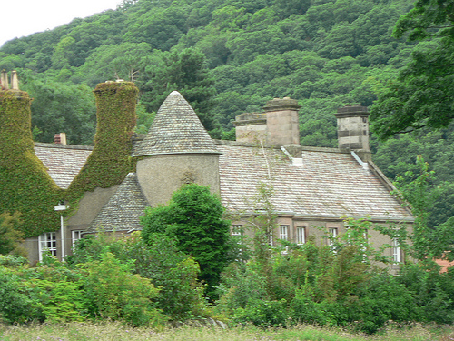
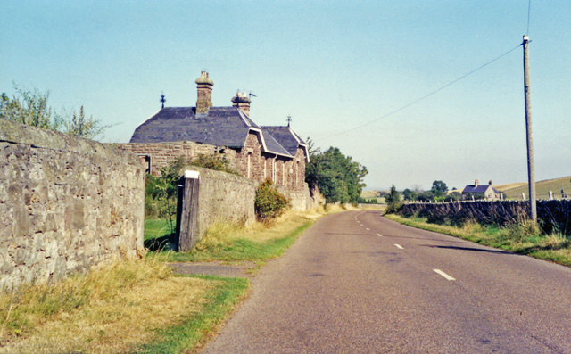
| Hethpool House | 1042321 | II | 1919 | Icorporates earlier building of 1687. |
| Hethpool Tower | 1042322 | II | ||
| Kirknewton House | 1153782 | II | ||
| Shelter Sheds and Granary at West Kirknewton Farm | 1042327 | II | ||
| Shelter Sheds Circa 90 Yards South of Westnewton House | 1153806 | II | ||
| Summerhouse Circa 70 Yards North of Hethpool House | 1370913 | II | ||
| The Old Vicarage | 1042326 | II | ||
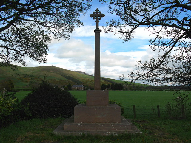
| War Memorial | 1153789 | II | 1921 | |
| Westnewton Bridge | 1042320 | II | ||
| West Hill camp | 1006534 | n/a | Scheduled Monument | |
| St Gregory's Hill camp | 1006535 | n/a | Scheduled Monument | |
| Enclosed settlement 920m south east of Whitehall | 1020585 | n/a | Scheduled Monument | |
| Hethpool tower house | 1018439 | n/a | Scheduled Monument | |
| Romano-British farmstead 760m north of Whitehall | 1019925 | n/a | Scheduled Monument | |
| Romano-British settlement 810m south east of Whitehall | 1019927 | n/a | Scheduled Monument | |
| Unenclosed settlement, part of a field system, Romano-British aggregate village and group of shielings, 470m south east of Whitehall | 1019929 | n/a | Scheduled Monument | |
| Settlement, probably medieval, SW of Torleehouse | 1006426 | n/a | Scheduled Monument | |
| Romano-British settlements E of Yeavering Bell containing the Old Sheepfold settlement and settlements to the W and S of it | 1006427 | n/a | Scheduled Monument | |
| Site SE of Yeavering | 1006450 | n/a | Scheduled Monument | |
| Settlement N of White Law | 1006456 | n/a | Scheduled Monument | |
| Settlement on north east slope of Yeavering Bell | 1006459 | n/a | Scheduled Monument | |
| Settlement, field systems and terraces on the south east slope of Yeavering Bell | 1006460 | n/a | Scheduled Monument | |
| Settlement on the east slope of The Bell | 1006465 | n/a | Scheduled Monument | |
| Settlement on north slope of Yeavering Bell | 1006466 | n/a | Scheduled Monument | |
| Settlement SW of Mid Hill | 1006482 | n/a | Scheduled Monument | |
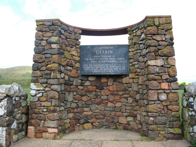
| Ad Gefrin Anglo-Saxon township and prehistoric remains | 1006519 | n/a | Scheduled Monument. One of the most significant sites in early Northumbrian history. | |
| Yeavering Bell camp | 1006561 | n/a | Scheduled Monument | |
| The Battle Stone, 650m WNW of Yeavering Farm | 1006562 | n/a | Scheduled Monument | |
| Staw Hill defended settlement | 1008218 | n/a | Scheduled Monument | |
| Roman period native settlement 200m SSE of Staw Hill defended settlement | 1008219 | n/a | Scheduled Monument | |
| Mid Hill enclosed settlement, Westnewton | 1008358 | n/a | Scheduled Monument | |
| Enclosed settlement west of Mid Hill | 1008359 | n/a | Scheduled Monument | |
| House platform north west of Laddie's Knowe settlement | 1008360 | n/a | Scheduled Monument | |
| Settlements and cairn east of Laddies Knowe | 1008363 | n/a | Scheduled Monument | |
| Settlement north of Coldburn | 1008477 | n/a | Scheduled Monument | |
| Settlement north west of Ell's Knowe | 1008478 | n/a | Scheduled Monument | |
| Farmstead and cultivation terraces, ENE of Stawhouse | 1008505 | n/a | Scheduled Monument | |
| Settlement at Scaldhill Shank | 1008744 | n/a | Scheduled Monument | |
| Settlement WSW of Ell's Knowe | 1009039 | n/a | Scheduled Monument | |
| Ell's Knowe defended settlement and earlier palisaded site | 1009040 | n/a | Scheduled Monument | |
| Roman period native farmstead 550m SW of Trowupburn Farm | 1009528 | n/a | Scheduled Monument | |
| Sinkside Hill defended settlement | 1009529 | n/a | Scheduled Monument | |
| Settlement at the south end of The Bell | 1002912 | n/a | Scheduled Monument | |
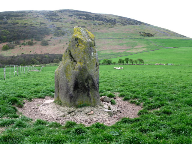
| Hethpool stone circles | 1010332 | n/a | Scheduled Monument | |
| Trowupburn cairn group | 1010333 | n/a | Scheduled Monument | |
| Madam Law Cairn | 1010335 | n/a | Scheduled Monument | |
| North Black Hagg defended settlement | 1010336 | n/a | Scheduled Monument | |
| Little Hetha defended settlement | 1014483 | n/a | Scheduled Monument | |
| Hut circle 920m SSW of Mounthooly | 1014487 | n/a | Scheduled Monument | |
| Roman period native enclosed farmstead 320m north west of Southernknowe | 1014488 | n/a | Scheduled Monument | |
| Round cairn 540m NNW of Southernknowe | 1014489 | n/a | Scheduled Monument | |
| Round cairn 550m NNW of Southernknowe | 1014490 | n/a | Scheduled Monument | |
| Roman period native enclosed farmstead 370m WNW of Southernknowe | 1014491 | n/a | Scheduled Monument | |
| Fawcett Shank defended settlement, 620m SSE of Fleehope | 1014492 | n/a | Scheduled Monument | |
| Roman period native enclosed farmstead, 470m ESE of Fleehope | 1014493 | n/a | Scheduled Monument | |
| Shieling 930m SSW of Mounthooly | 1014494 | n/a | Scheduled Monument | |
| Shieling 950m SSW of Mounthooly | 1014495 | n/a | Scheduled Monument | |
| Hetha Burn defended settlement, Roman period native enclosed settlement and associated trackways | 1014497 | n/a | Scheduled Monument | |
| Shieling at Southernknowe, 530m SSE of Whitehall | 1014498 | n/a | Scheduled Monument | |
| Roman period native enclosed settlement 460m north of Sutherland Bridge | 1014499 | n/a | Scheduled Monument | |
| Roman period native enclosed settlement 480m north of Sutherland Bridge | 1014500 | n/a | Scheduled Monument | |
| Roman period native enclosed settlement 270m ESE of Fleehope | 1014501 | n/a | Scheduled Monument | |
| Hut circle settlements and field systems at Hetha Burn Head | 1014504 | n/a | Scheduled Monument | |
| Trowupburn Roman period native enclosed settlement, 120m north of Trowupburn Farm | 1014507 | n/a | Scheduled Monument | |
| Great Hetha defended settlement | 1014508 | n/a | Scheduled Monument | |
| Roman period native enclosed settlement and medieval sheiling 165m north east of Dunsdale | 1014680 | n/a | Scheduled Monument | |
| Bronze Age cairnfield, prehistoric enclosure, Romano-British settlement and medieval shielings 500m south of Mounthooly | 1014769 | n/a | Scheduled Monument | |
| Southernknowe Roman period native enclosed settlement and clearance cairns, 280m north of Sutherland Bridge | 1014871 | n/a | Scheduled Monument | |
| Round cairn 100m south of Torleehouse | 1014920 | n/a | Scheduled Monument | |
| Roman period native settlement, associated field system and trackway, and medieval farmstead 270m south of Torleehouse | 1014921 | n/a | Scheduled Monument | |
| Roman period native settlement on east slope of Mid Hill, 520m south of Staw Hill Camp | 1014933 | n/a | Scheduled Monument | |
| Roman period native enclosed settlement 370m WNW of Great Hetha defended settlement | 1015193 | n/a | Scheduled Monument | |
| Shieling and enclosure 840m SSW of Mounthooly | 1015194 | n/a | Scheduled Monument | |
| Enclosed native settlements, cultivation terraces and cairn field south west of Mounthooly | 1015647 | n/a | Scheduled Monument | |
| Three Roman period native settlements and later droveway 750m south west of Torleehouse | 1016138 | n/a | Scheduled Monument | |
| Roman period native settlement 340m east of Hethpool Linn | 1016143 | n/a | Scheduled Monument | |
| Settlement 500yds (460m) SW of White Law | 1006455 | n/a | Scheduled Monument | |
| Roman period native enclosed settlement 600m north east of Elsdonburn Shank | 1015195 | n/a | Scheduled Monument | |
| Former Kirknewton Railway Station | Not listed | n/a | c.1887 | |
| Kirknewton Conservation Area | - | n/a | - | Conservation Area |
Primary source: the National Heritage List for England - NHLE is the register of nationally protected historic buildings and sites in England, including listed buildings, scheduled monuments, protected wrecks, registered parks and gardens, and battlefields. The list is maintained by Historic England. Check NHLE for updates and new entries. Secondary sources: British Listed Buildings and Keys to the Past. Non listed buildings may be included from a ‘local list’, or added on an ad-hoc basis by Co-Curate members if a ‘local list’ has not been published by the relevant council.
Co-Curate Page
Church of St Gregory the Great, Kirknewton
- Overview Map Street View St Gregory's is the parish church of Kirknewton in Northumberland. There has been a church on this site since at least the 11th century. The church …
Co-Curate Page
War Memorial, Kirknewton
- Overview Map Street View The war memorial in Kirknewton, Northumberland was dedicated to the 31 men of Kirknewton Parish who lost their lives in the First World War. It was …
Co-Curate Page
Ad Gefrin
- Overview Map Street View Between Kirknewton and Yeavering in Northumberland are the extensive remains of the Anglo-Saxon royal township of Ad Gefrin. It was a large settlement covering an area …
Co-Curate Page
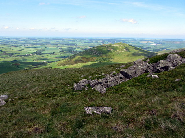
Hillfort, Yeavering Bell
- Overview Map Aerial view of Yeavering Bell hillfort on Google Maps. The walls (originally 2+m high, now collapsed with a spread of 8-9m) are clearly visible. The remains of a …
Co-Curate Page
Hethpool House
- Overview Map Street View Hethpool House was built in 1919 by Cahill of Alnwick. It incorporates masonry from a much earlier building of 1687. The building is Grade II listed …
Co-Curate Page
Former Kirknewton Railway Station
- The station to the north-east of Kirknewton in Northumberland was on the Alnwick-Cornhill Railway (the 'Cornhill branchline'). The station was opened on the 5th of September 1887 by the North …

Co-Curate Page
Settlement at the south end of The Bell
- Map showing Hethpool and the Scheduled Monument area to the north east. The Bell is a hill to the north-east of Hethpool in Northumberland (no to be confused with the …

Co-Curate Page
Church of St Gregory the Great, Kirknewton
- Overview Map Street View St Gregory's is the parish church of Kirknewton in Northumberland. There has been a church on this site since at least the 11th century. The church …
Co-Curate Page
War Memorial, Kirknewton
- Overview Map Street View The war memorial in Kirknewton, Northumberland was dedicated to the 31 men of Kirknewton Parish who lost their lives in the First World War. It was …
Co-Curate Page
Ad Gefrin
- Overview Map Street View Between Kirknewton and Yeavering in Northumberland are the extensive remains of the Anglo-Saxon royal township of Ad Gefrin. It was a large settlement covering an area …
Co-Curate Page
Hillfort, Yeavering Bell
- Overview Map Aerial view of Yeavering Bell hillfort on Google Maps. The walls (originally 2+m high, now collapsed with a spread of 8-9m) are clearly visible. The remains of a …
Co-Curate Page
Hethpool House
- Overview Map Street View Hethpool House was built in 1919 by Cahill of Alnwick. It incorporates masonry from a much earlier building of 1687. The building is Grade II listed …
Co-Curate Page
Former Kirknewton Railway Station
- The station to the north-east of Kirknewton in Northumberland was on the Alnwick-Cornhill Railway (the 'Cornhill branchline'). The station was opened on the 5th of September 1887 by the North …


