Topics > Civil Parishes in Cumbria > Kirkby Stephen Town Council Area > Historic Buildings and Monuments in Kirkby Stephen
Historic Buildings and Monuments in Kirkby Stephen
Listed buildings and scheduled monuments in Kirkby Stephen Civil Parish, Cumbria, from the National Heritage List for England[1]. Use the Search (below) if looking for a specific building / monument.
| Structure | List No. | Grade | Built~ | Note |
|---|---|---|---|---|
| No. 1, the Green | 1145030 | II | 1666 | The Green |
| No. 13, Market Street | 1145036 | II | C19th | Market Street |
| No. 14, Market Street | 1137016 | II | C19th | Market Street |
| Nos. 2 and 3, Nateby Road | 1145042 | II | C19th | Nateby Road |
| Nos. 23 and 25, Market Square | 1136954 | II | C18th | Market Square |
| No. 27, Market Square | 1136972 | II | 1816 | Market Square |
| No. 28, Market Street | 1326931 | II | C19th | Market Street |
| No. 3, Market Street | 1312527 | II | C19th | Market Street |
| No. 32, Market Street | 1137034 | II | C19th | Market Street |
| No. 34, Market Street | 1145039 | II | C19th | Market Street |
| No. 35, Market Square | 1136994 | II | 1636 | Market Square |
| No. 36, Market Square | 1326929 | II | C19th | Market Square |
| No. 36, Market Street | 1137038 | II | C19th | Market Street |
| No. 39, North Road | 1137066 | II | C19th | North Road |
| No. 4, Melbecks | 1137046 | II | C18th | Melbecks |
| No. 40, Market Street | 1137041 | II | C19th | Market Street |
| No. 41, North Road | 1145043 | II | C19th | North Road |
| Nos. 43 and 45, North Road and 3 and 4, Church Walk | 1326953 | II | C19th | North Road |
| No. 61, Croft Street | 1145027 | II | C19th | Croft Street |
| Barclays Bank and Area Railings to Front | 1326930 | II | 1903 | Market Street |
| Barn on South Corner with Croft Street | 1145028 | II | C19th | Faraday Street |
| Black Bull Hotel | 1326932 | II | C19th | Market Street |
| Brougham House | 1136912 | II | 1794 | High Street |
| Church Hall | 1145007 | II | 1677 | Vicarage Lane |
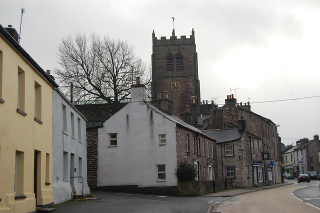
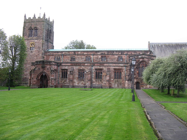
| Church of St Stephen | 1136925 | II* | c.1240 | Parts rebuilt in 1847. |
| Croft House and Adjacent Shop | 1137028 | II | 1789 | Market Street |
| Eden Lodge | 1145005 | II | C19th | Stoneshot |
| Fletcher House | 1145040 | II | 1837 | Market Street |
| Forecourt Gate and Railings to Manor House | 1312513 | II | C18th | Melbecks |
| Forecourt Gate and Railings to Mitre House | 1145033 | II | C19th | Market Square |
| Forecourt Gates and Railings to Fletcher House | 1326933 | II | C19th | Market Street |
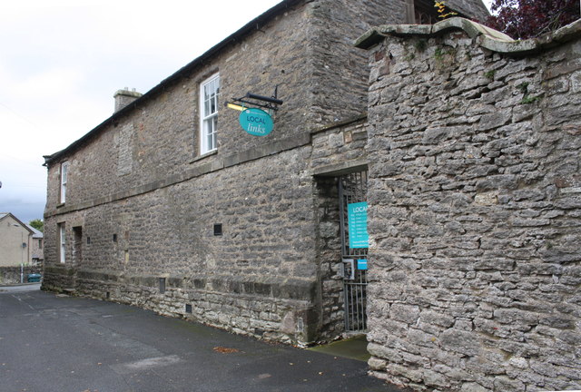
| Former Grammar School | 1145006 | II | C16th | Vicarage Lane. Now the Local Links centre. |
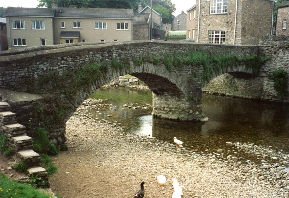
| Frank's Bridge | 1145010 | II | C17th | Footbridge over River Eden. Partly in this parish. |
| House Adjoining Temperance Hall to East | 1326934 | II | C19th | Nateby Road |
| House to Rear of Number 16 | 1145038 | II | 1795 | Market Street |
| King's Arms Hotel | 1137008 | II | C18th | Market Street |
| Kirkby Stephen War Memorial | 1457753 | II | 1920 | Market Square |
| Lowmill Bridge | 1326954 | II | C17th | |
| Mitre House | 1136938 | II | 1663 | Market Square |
| North Lodge to Stobars Hall | 1145009 | II | C19th | Waitby Road |
| Nos. 16 and 18, Market Street | 1145037 | II | C18th | Market Street |
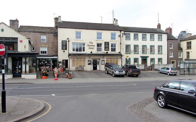
| Pennine Hotel | 1145034 | II | C19th | Market Square |
| Railway Overbridge at NY770075 | 1145019 | II | 1861 | A685 |
| Redmayne House | 1145029 | II | 1787 | Faraday Road |
| Shop to North East Corner | 1145032 | II | C18th | Market Square |
| Shop to North of Mitre House | 1326927 | II | C18th | Market Square |
| Shop to south west corner | 1326928 | II | 1817 | Market Square |
| Sleddall House and Area Railings | 1145035 | II | C18th | Market Square |
| Stobars Hall | 1145008 | II | 1829 | On site of earlier building |
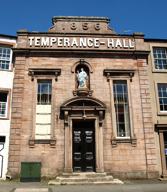
| Temperance Hall | 1137058 | II | 1856 | Nateby Road |
| The Cloisters, Including Railings and Gates | 1145031 | II | 1810 | Market Square |
| The Manor House | 1145041 | II | 1672 | Melbecks |
| Croglam Castle defended Iron Age settlement | 1004615 | n/a | Iron Age | Scheduled Monument |
| Intake Bottom settlement enclosure and hut circle, 500m WSW of Croglam Castle | 1007085 | n/a | Scheduled Monument | |
| Waitby Castle enclosed Romano-British settlement and part of a medieval dyke | 1018063 | n/a | Roman | Scheduled Monument |
| Two Romano-British enclosed settlements and an associated regular aggregate field system at Waitby Intake | 1018064 | n/a | Scheduled Monument | |
| Kirkby Stephen Conservation Area | - | n/a | Conservation Area |
Primary source: the National Heritage List for England - NHLE is the register of nationally protected historic buildings and sites in England, including listed buildings, scheduled monuments, protected wrecks, registered parks and gardens, and battlefields. The list is maintained by Historic England. Check NHLE for updates and new entries. Secondary sources: British Listed Buildings.
Co-Curate Page
Church of St Stephen
- Overview About St Stephen's Church Map Street View St Stephen's Church is the parish church of Kirkby Stephen. It is sometimes called the "Cathedral of the Dales" in reference to …
Co-Curate Page
Frank's Bridge
- Overview About Frank's Bridge Map Street View Frank's Bridge is a narrow pedestrian stone footbridge over the River Eden in Kirkby Stephen. It was built in the 17th century as …
Co-Curate Page
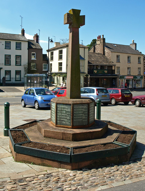
War Memorial
- Overview Map Street View The war memorial in Kirkby Stephen is located in the market square. The memorial is in the style of a 15th century cross made of Lazonby …
Co-Curate Page
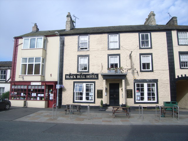
Black Bull Hotel, Kirkby Stephen
- Overview Map Street View The Black Bull is located on Market Street in Kirkby Stephen. The hotel dates from the early 19th century and is a Grade II listed building …
Co-Curate Page
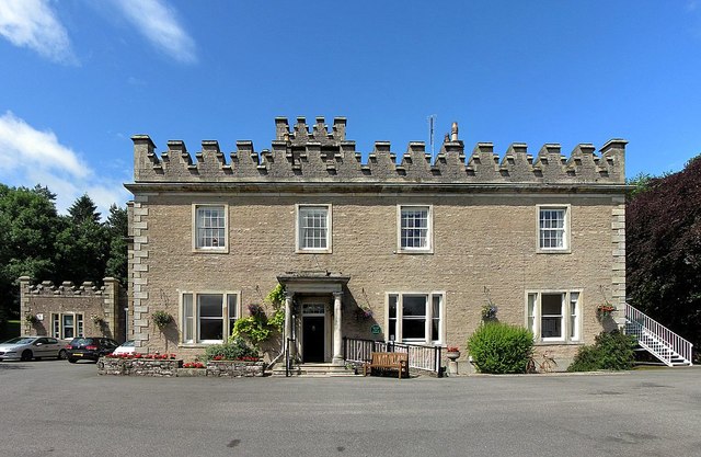
Stobars Hall, Kirkby Stephen
- Overview Map Street View Stobars Hall is a former mansion, located about ½ mile west of Kirkby Stephen. The hall incorporates datestones of 1695 and 1866, but the present building …
Co-Curate Page
Old Grammar School, Kirkby Stephen
- Overview Map Street View The old Grammar School building is located on Vicarage Lane in Kirkby Stephen. The coursed rubble building has a bellcote to it's south end and a …
Co-Curate Page
Croglam Castle (Iron Age site)
- Overview Map This is a Scheduled Monument at the south-west of Kirkby Stephen. It includes the earthwork and buried remains of a defended settlement of Iron Age date, situated on …
Co-Curate Page
Waitby Castle (Romano-British settlement)
- Overview Map Castle Hill is located about ¼ mile east of the village of Waitby and 1 mile west of Kirkby Stephen. Waitby Castle is an oval-shaped Romano-British hilltop enclosure situated …

Co-Curate Page
Church of St Stephen
- Overview About St Stephen's Church Map Street View St Stephen's Church is the parish church of Kirkby Stephen. It is sometimes called the "Cathedral of the Dales" in reference to …
Co-Curate Page
Frank's Bridge
- Overview About Frank's Bridge Map Street View Frank's Bridge is a narrow pedestrian stone footbridge over the River Eden in Kirkby Stephen. It was built in the 17th century as …
Co-Curate Page
War Memorial
- Overview Map Street View The war memorial in Kirkby Stephen is located in the market square. The memorial is in the style of a 15th century cross made of Lazonby …
Co-Curate Page
Black Bull Hotel, Kirkby Stephen
- Overview Map Street View The Black Bull is located on Market Street in Kirkby Stephen. The hotel dates from the early 19th century and is a Grade II listed building …
Co-Curate Page
Stobars Hall, Kirkby Stephen
- Overview Map Street View Stobars Hall is a former mansion, located about ½ mile west of Kirkby Stephen. The hall incorporates datestones of 1695 and 1866, but the present building …
Co-Curate Page
Old Grammar School, Kirkby Stephen
- Overview Map Street View The old Grammar School building is located on Vicarage Lane in Kirkby Stephen. The coursed rubble building has a bellcote to it's south end and a …
Co-Curate Page
Croglam Castle (Iron Age site)
- Overview Map This is a Scheduled Monument at the south-west of Kirkby Stephen. It includes the earthwork and buried remains of a defended settlement of Iron Age date, situated on …