Topics > County Durham > Civil Parishes in County Durham > Croxdale and Hett Civil Parish > Historic Buildings and Monuments in Croxdale and Hett
Historic Buildings and Monuments in Croxdale and Hett
Listed buildings and scheduled monuments in Croxdale and Hett, County Durham, from the National Heritage List for England[1]. Use the Search (below) if looking for a specific building / monument.
| Structure | List No. | Grade | Built~ | Note |
|---|---|---|---|---|
| Sunderland Bridge | 1120699 | I | C14th | Partly in Brandon and Byshottles CP |
| 1-20, & 21-38, Front Street | 1323185 | II | 1875 | Terraced housing for the Wearside Iron & Coal Co. |
| Bank House Farmhouse | 1120777 | II | C18th | Sunderland Bridge |
| Barn at East Farm 30 Metres North West of the Hermitage | 1120746 | II | C18th | Sunderland Bridge |
| Bridge 170 Metres North of the Mill House | 1159129 | II | c.1760 | Over Croxdale Beck, Croxdale |
| Church 50 Metres North East of Croxdale Hall | 1120740 | I | C12th | |
| Church of St Bartholomew | 1159286 | II | 1846 | Sunderland Bridge |
| Cross Shaft Base 8 Metres South of Church to North East of Croxdale Hall | 1120741 | II | Medieval | |
| Croxdale Hall | 1159140 | I | C17th | On medieval site |
| Croxdale Wood House | 1323184 | II | C18th | |
| Garden Wall and Gates to South East of Croxdale Hall | 1120780 | II | C18th | |
| Gazebo, Gate Piers and Garden Walls to East and South of the Hermitage | 1311104 | II | C18th | Sunderland Bridge |
| Haybarn and Rear Yard Walls 110 Metres East of Croxdale Hall | 1323222 | II* | C18th | |
| High Croxdale Farmhouse and Flanking Barns | 1120743 | II | C18th | |
| High Grange Farmhouse and Attached Farmbuildings | 1159310 | II | C18th | Hett |
| Low Butterby Farmhouse and Barn Adjoining at South-East | 1323186 | II* | C17th | |
| Moat Walls, 2 Bridges Across Moat, Garden Wall and Gate Piers at Low Butterby Farm | 1159261 | II* | Medieval | |
| North and East Courtyard Ranges and Walls, to East of Croxdale Hall | 1120779 | II | C18th | |
| Orangery, Walls and Gate Piers to East of Croxdale Hall | 1323221 | II | 1765 | |
| Priests House 90 Metres East of Croxdale Hall | 1120739 | II* | C18th | |
| Slashpool House | 1120742 | II | 1708 | Hett |
| South Courtyard Range and Cottage, to East of Croxdale Hall | 1159165 | II | C17th | |
| The Hermitage | 1323187 | II | C17th | House, Sunderland Bridge |
| The Meadows | 1159308 | II | C18th | House, Sunderland Bridge |
| The Mill House | 1120778 | II | 1771 | Former mill, now house. |
| Two Farmbuildings, Flanking Drive to South East of Low Butterby Farmhouse | 1120744 | II | C17th | |
| Walls Surrounding Paddock to East of Low Butterby Farmhouse | 1120745 | II | C17th | |
| Croxdale Hall - Grounds | 1001271 | II | C18th | Listed Park and Garden |
| Croxdale medieval chapel and churchyard cross base | 1019820 | n/a | Medieval | Scheduled Monument |
| Sunderland Bridge, near Croxdale | 1002358 | n/a | c.1760 | Scheduled Monument |
| Moated site at Low Butterby Farm | 1008663 | n/a | Medieval | Scheduled Monument |
Primary source: the National Heritage List for England - NHLE is the register of nationally protected historic buildings and sites in England, including listed buildings, scheduled monuments, protected wrecks, registered parks and gardens, and battlefields. The list is maintained by Historic England. Check NHLE for updates and new entries.
Secondary sources: British Listed Buildings and Keys to the Past.
Co-Curate Page
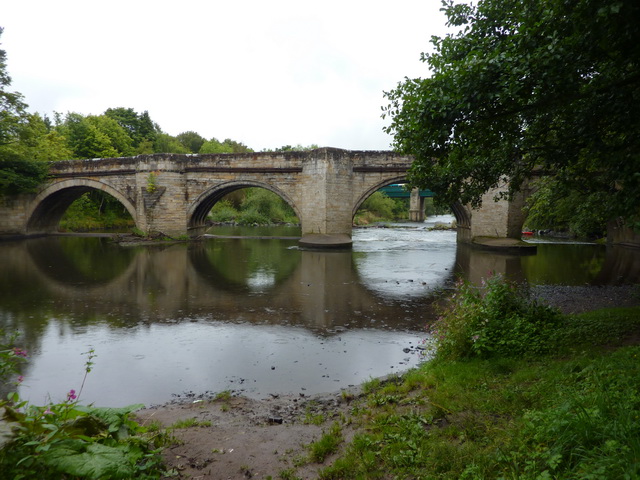
Sunderland Bridge (bridge)
- Overview Map Street View This stone bridge across the River Wear near the village of Sunderland Bridge, Croxdale, dates from the 14th Century. The bridge has undergone several modifications, with …
Co-Curate Page
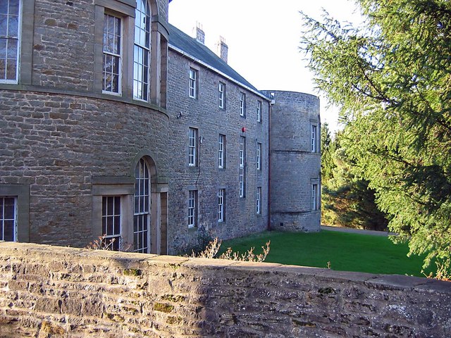
Croxdale Hall
- Overview About Croxdale Hall Map Croxdale Hall is a privately owned country mansion located about half a mile north of the modern village Croxdale in County Durham. The Hall has …
Co-Curate Page
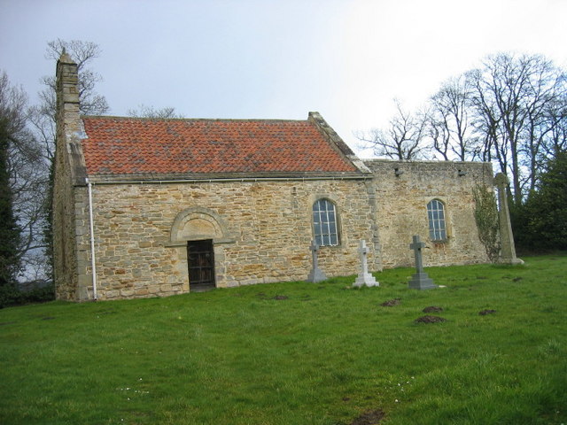
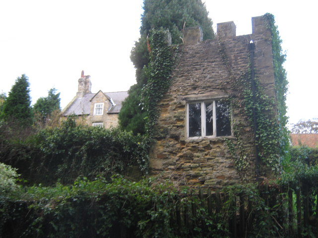
Old Chapel, Croxdale
- The "Old Church" of St Bartholomew, located by Croxdale Hall, was originally built in the late 11th, or early 12th century. It was formerly a chapel of ease for St …
Co-Curate Page
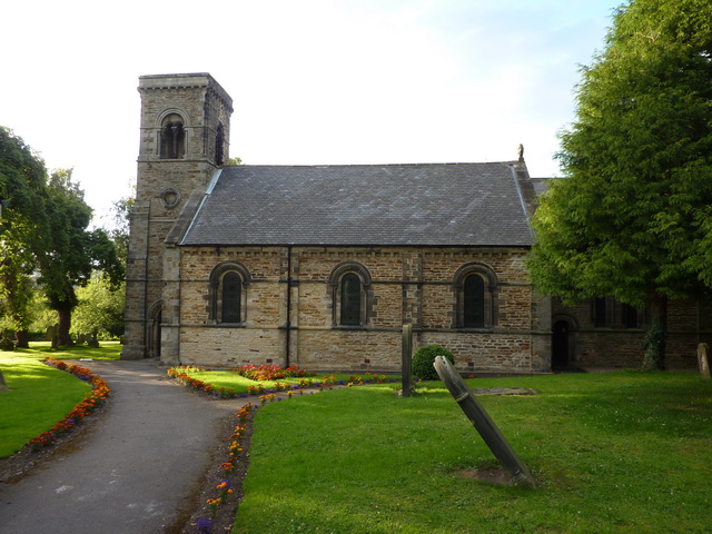
Church of St Bartholomew
- Overview Map Street View St Bartholomew's is the parish church in Sunderland Bridge, County Durham. The church was built 1843-1846 by George Pickering. St Bartholomew's Church is Grade II listed on …
Co-Curate Page
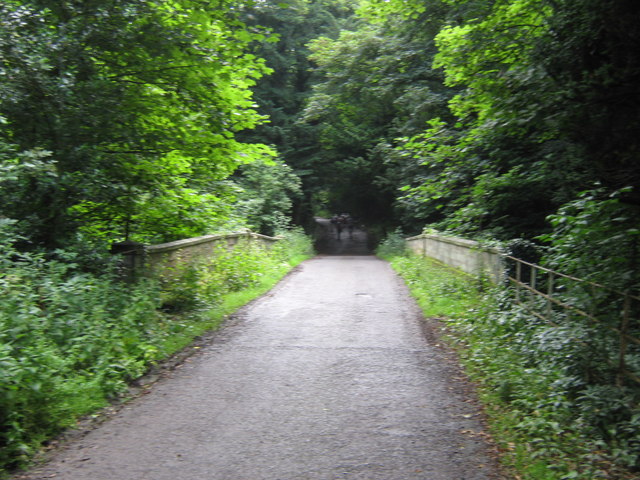
Bridge over Croxdale Beck
- Overview Map A stone single-track road bridge over Croxdale Beck, built c.1760 by Christopher Ebdon.[1] It is located just north of Sunderland Bridge, near Croxdale Hall. The bridge was built …
Co-Curate Page
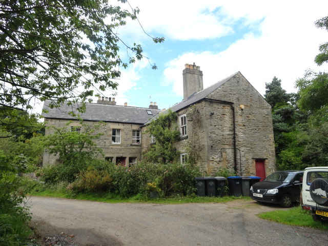
Croxdale Wood House
- Overview Map Croxdale Wood House is an 18th century farmhouse located by Croxdale Woods, about a mile north-east of Sunderland Bridge and Croxdale. It was extended in the mid 19th …
Co-Curate Page
The Hermitage
- Overview Map Street View The 'Hermitage' is a large mid 17th century house, with c1930 alterations and additions. The Hermitage is Grade II listed on the National Heritage List for …

Co-Curate Page
Sunderland Bridge (bridge)
- Overview Map Street View This stone bridge across the River Wear near the village of Sunderland Bridge, Croxdale, dates from the 14th Century. The bridge has undergone several modifications, with …
Co-Curate Page
Croxdale Hall
- Overview About Croxdale Hall Map Croxdale Hall is a privately owned country mansion located about half a mile north of the modern village Croxdale in County Durham. The Hall has …
Co-Curate Page
Old Chapel, Croxdale
- The "Old Church" of St Bartholomew, located by Croxdale Hall, was originally built in the late 11th, or early 12th century. It was formerly a chapel of ease for St …
Co-Curate Page
Church of St Bartholomew
- Overview Map Street View St Bartholomew's is the parish church in Sunderland Bridge, County Durham. The church was built 1843-1846 by George Pickering. St Bartholomew's Church is Grade II listed on …
Co-Curate Page
Bridge over Croxdale Beck
- Overview Map A stone single-track road bridge over Croxdale Beck, built c.1760 by Christopher Ebdon.[1] It is located just north of Sunderland Bridge, near Croxdale Hall. The bridge was built …
Co-Curate Page
Croxdale Wood House
- Overview Map Croxdale Wood House is an 18th century farmhouse located by Croxdale Woods, about a mile north-east of Sunderland Bridge and Croxdale. It was extended in the mid 19th …


