Topics > Northumberland > Welton > Welton Medieval Settlement
Welton Medieval Settlement
Scheduled Monument areas - based on Historic England data (Open Government Licence).
Welton in Northumberland, situated to the south of Whittle Burn, is the site of a deserted medieval village. The buried remains of the settlement showcase a distinct planned layout from the 11th or 12th century, likely established under Norman influence. The village had two main rows of houses, running roughly east-west, separated by a village street (now a hollow way). It has around 12 distinct tofts (house platforms), which originally held timber longhouses, roughly 15 meters in length. Behind each toft lie long, narrow enclosures known as crofts. The settlement was enclosed by a perimeter bank of earth and stone, which separated the housing area from the surrounding open field system, with ridge and furrow earthworks still visible to the south of the village. The village also had a series of sub-rectangular fishponds, fed by a water channel and a stone sluice, located at the southeastern corner of the site. The remains of the settlement are a Scheduled Monument (legally protected).
Scheduled Monument (#1016866): Welton medieval settlement, open field system and fishponds
Click the headings below to expand (selected extracts from the Historic England scheduling)
The medieval village remains at Welton are well preserved and retain significant archaeological deposits. Taken together with the remains of the open field system and the fishponds, they will contribute to our knowledge and understanding of the development of medieval settlement in the region.
The monument includes remains of the medieval settlement of Welton, part of its associated field system and a series of fishponds of medieval date, situated on the south side of the valley of the former Whittle Burn. Welton Tower 75m to the north east is the subject of a separate scheduling. The historical context of the monument is recorded in several documents.
The manor of Welton, which was originally a member of the barony of Prudhoe, was given to Tynemouth Priory by the end of the 12th century. It was subsequently granted to Simon de Welton, in whose family it remained until the end of the 17th century. At this date the manor became part of the Blackett, and later Allendale Estate. By the late 18th century the village and its fields had been enclosed and four individual farms had been created. The medieval plan of the village is a type well known in this part of Northumberland, in which a single row, or two parallel rows of houses face onto a rectangular village green or hollow way, with crofts or garden areas to the rear. This type of village in northern England is thought to be the result of deliberate planning by Norman rulers attempting to exert control over a rebellious region during the 11th and 12th centuries.
With the exception of two tofts, Welton has been totally abandoned. The remains survive as a series of prominent earthworks situated between Welton Hall Farm and Welton Farm. The former farm retains remains of the manor house including Welton Tower, a late addition of the 15th century. The earthworks of the main south row of the village are visible as a series of at least 12 rectangular platforms or tofts, orientated east to west and containing the sites of individual timber longhouses. Where the longhouses are visible as earthworks, they are on average 15m long and between 0.2m to 1m high, and divided unequally into two rooms. To the rear of each toft there are the well defined remains of an elongated enclosure or croft, each bounded from its neighbour by a hollow way, drainage gully or a low bank, the latter standing on average 0.5m high. The crofts at the eastern end of the row are 80m long and at the western end they are 60m long. At the eastern end of the row there are less well defined remains of up to six further crofts.
The row is bounded on the south side by a narrow lane, visible as a slight hollow way and then by a continuous perimeter bank of earth and stone which served to separate the village from the surrounding, formerly more extensive open field system. The perimeter bank continues around the eastern end of the village. The main street of Welton fronts onto a prominent hollow way on average 20m to 23m wide bounded by banks. An irregular pattern of four rectangular tofts, which are thought to be the remains of an unplanned north row, separated from, but parallel to the south row are thought to be a relatively late addition to the village. Part of the formerly more extensive open field system which surrounded the village survives to the south of the village perimeter bank. Here there are three medieval furlongs or fields bounded by intact headlands measuring up to 4m wide and standing up to 1m high. Each furlong contains ridge and furrow. At the south eastern corner of the monument there are a series of sub-rectangular hollows of varying sizes, interpreted as the remains of a group of fishponds. The fishponds are served by a leat entering the system from the west through the remains of a denuded stone feature thought to have been a sluice.
from https://www.heritagegateway.o…
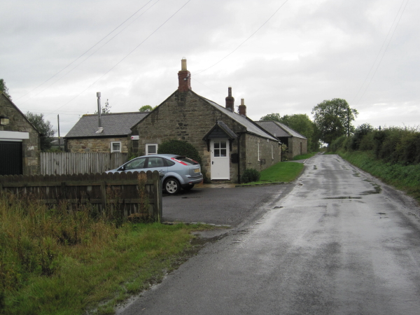
Welton medieval settlement, open field system and fishponds (Horsley)
- A single wide main street with the foundations of house sites on either side. The rows of houses are very clear set in a line parallel with the street. (1) …
Added by
Simon Cotterill

from https://historicengland.org.u…
Welton medieval settlement, open field system and fishponds
- ....Medieval villages were organised agricultural communities, sited at the centre of a village or township, that shared resources such as arable land, meadow and woodland. Village plans varied enormously, but …
Added by
Simon Cotterill

from https://www.geograph.org.uk/p…
Deserted Medieval Village of Welton
- The lumps and bumps visible in this field and in aerial photos taken in good conditions are the remains of the tracks, buildings and boundaries of the deserted medieval village …
Added by
Simon Cotterill
Co-Curate Page
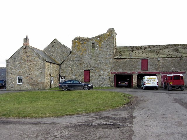
Welton Tower House
- Overview Map Street View The remains of a 15th century tower house are located within the farm complex at Welton. The tower house was originally on the street line at …

from https://www.heritagegateway.o…
Welton medieval settlement, open field system and fishponds (Horsley)
- A single wide main street with the foundations of house sites on either side. The rows of houses are very clear set in a line parallel with the street. (1) …
Added by
Simon Cotterill
from https://historicengland.org.u…
Welton medieval settlement, open field system and fishponds
- ....Medieval villages were organised agricultural communities, sited at the centre of a village or township, that shared resources such as arable land, meadow and woodland. Village plans varied enormously, but …
Added by
Simon Cotterill
from https://www.geograph.org.uk/p…
Deserted Medieval Village of Welton
- The lumps and bumps visible in this field and in aerial photos taken in good conditions are the remains of the tracks, buildings and boundaries of the deserted medieval village …
Added by
Simon Cotterill