Topics > Northumberland > Wark-on-Tyne > Wark Parish, 1855
Wark Parish, 1855
Extract from: History, Topography, and Directory of Northumberland...Whellan, William, & Co, 1855.
WARK PARISH
WARK parish comprises the townships of Shitlington (High) Quarter, Shitlington (Low) Quarter, Wark, and Warksburn, which were formerly a portion of the extensive parish of Simonburn, from which they were severed and made into a distinct parish, by the act of 51 Geo. III. cap. 194. It comprises an area of 22,986 acres, and its population in 1801, was 728; in 1811, 783; in 1821, 866; in 1831, 861; in 1841, 940; and in 1851, 865 souls. There are traces of numerous encampments in various parts of this district. The Raven's Crag, so called from its being the solitary and secure retreat of that bird, is a steep range of freestone rocks, situated at the southern extremity of the parish. At the west end of these lofty crags, there is a fine spring over-shadowed by a natural arch, and in its vicinity, are broken masses of rock lying in the wildest disorder.
SHITLINGTON (HIGH) is a township in this parish, situated three miles west of Wark. It is the property of H. Allgood, Esq. and W. H. Charlton, Esq., the former of whom is lord of the manor. It contains 8,755 acres, and its rateable value is £1,326. The number of inhabitants in 1801, was 80; in 1811, 99; in 1821, 104; in 1831, 108; in 1841, 106; and in 1851, 88 souls.
|
Farmers Armstrong James, High Bridge Charlton Christopher, High Bridge Clark Roger, Blackbum Dodd Archibald Dodd Joseph |
Hedley John, Hindridge Millburn Joseph, Barneystead Mole Joseph, Stone House Thompson Henry Thomas, yeoman, Watergate Wilkinson John, Barneystead |
SHITLINGTON (LOW) is a township, the property of H. Allgood, Esq., who is also the lord of the manor. It is situated about two and a half miles west by north of Wark, comprises 1,146 acres, and its rateable value is £723. The population in 1801, was 91; in 1811, 93; in 1821, 105; in 1831, 58; in 1841, 72; and in 1851, 77 souls. Coal is very abundant in this township and neighbourhood. Here are tile works carried on by Mr Francis Renwick. SHITLINGTON HALL, formerly the seat of the Allgood family, is now occupied by Mr. Christopher Dixon.
DIRECTORY. The farmers are Michael Atkinson, Shieldfield; John Dodd, Brown's Leases; George Moor, and corn miller; Christopher Nixon, yeoman, Shitlington Hall and Craig; and Arthur Storey, Billerley.
WARK is a township and village in the parish of the same name, the property of L. J. H. Allgood, Esq., John Ridley, Esq., and W. H. Charlton, Esq. The Duke of Northumberland is lord of the manor. Tho township contains 3,160 acres, its rateable value is .£1,686 15s, and the number of inhabitants in 1801, was 304; in 1811, 319; in 1821, 367; in 1831, 417; in 1841, 490; and in 1851, 483 souls. Here are a colliery and tile works. The manor of W ark was possessed by the Crown in the reign of Queen Elizabeth, and was granted by her successor James I., in 1603, to the Earl of Suffolk, but it subsequently became the property of the Radcliffe family, and on the attainder of the Earl of Derwentwater, it was given to the Commissioners of Greenwich Hospital, and is now possessed by the above-mentioned proprietors.
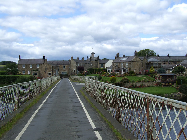
THE VILLAGE OF WARK occupies a low situation on the west side of the Tyne, about two and a half miles north of Simonburn. It is very ancient, but contains a number of good houses. THE CHURCH, a handsome Gothic structure with a square tower, was founded in 1815, and opened for service in 1818. The total expense of its erection, inclusive of the Rectory, was £7,410 17s., exclusive of the cost of the site. The living is a rectory in the archdeaconry of Northumberland and deanery of Bellingham, gross income £283. The patronage is vested in the Commissioners of Greenwich Hospital, and the Rev. John Marshall, M.A., is rector. The parish register commences in 1818. THE PRESBYTERHN CHAPEL was erected in 1848, at a cost-of £200; Rev. Mr. Wrightson, minister. THE GRAMMAR SCHOOl was founded by the will of Giles Heron, in 1679. The governors are the minister of Simonburn and nine trustees, who have the right of appointing the master, who must be approved of by the Bishop of Durham. It is free to the children of the inhabitants of the ancient parish of Simonburn, and of Chipchase, Birtley, and Birtley Shields, in the parish of Chollerton. The income is derived from rent, and at the time of the Charity Commissioners' report amounted to £45 per annum. In connexion with the Presbyterian Church is a school conducted by Mr. John Cuthbertson.
In 1787, a tumulus and two urns containing human bones, were discovered north of the village. The tumulus contained a stone coffin, formed of six slab stones, and having two large stones upon the lid, as if to fasten it down. As some workmen were levelling the ground in front of a building in this village, in the year 1804, they discovered a row of hewn stones, and on proceeding further came to a room thirty feet square, the walls of which were eight feet thick. It was fourteen feet deep and appeared to have had no outlet, as neither doors nor windows were visible. Four courses of stones on the outside, near the bottom, were composed of ashlar work, from which it would seem that it had not been connected with any other building under ground. The stones had the appearance of being burnt.
Near Wark, and close by the river, is an eminence, called Moat Hill, which was formerly crowned by a tower belonging to the Radcliffe family, but was subsequently used as a guard fort, and as an observatory for watching the motions of enemies. Half a mile north of W ark, near the place called Kirkfield, there formerly stood a church whose ruins are still visible, and from their magnitude we may conclude that the edifice to which they belonged. Was, at one time, of considerable extent.
CHARITIES. The poor share the charities of the parish of Simonburn, which see.
|
Armstrong William, surgeon Baty John, slater Cuthbertson John, schoolmaster Dodd Thomas, Esq. Dodd John, tailor Dixon Edward, general merchant commission agent, Gold Island Elliott John, cartwright Forster James, tailor and grocer Grimson Mr. John, Battle Steads Heslop William, mason Lamb William, tailor |
Martin Thomas, cooper Marshall Rev. John, rector Pearson William, blacksmith Philipson William, contractor, Northumberland House Richardson George, saddler Ridley George, Esq. Robson John Edward, brewer, Wark Brewery Sharp Ann, straw hat maker Thompson Misses Frances and Jane Turnbull William, blacksmith |
|
Boot and Shoemakers Davidson Robert Dodd Thomas Landerdale William Oswell Thomas Scott John Vitch George
Farmers Marked * are Yeomen Maughan Edward, Kirkfield Nixon George Robson James, Moat Hill Storey Arthur * Thompson Edward, Pasture House * |
Grocers & Dealers in Sundries Charlton John, and draper Charlton George Dodd Gilbert Fairlamb Ralph Forster Thomas Nixon Robert Smith Elizabeth Tulip Elizabeth
Inns Black Bull, W. Breckons Black Horse, Christopher Breckons Grey Bull, Thomas Storey Highland Drover, R. C, Pigg
Joiners Jamieson Edward Kirk Matthew Philipson John, & builder |
CARRIERS. To Newcastle, Edward Moor, on Thursday. To Hexham, Gilbert Dodd, on Thursday and Friday.
WARKSBURN township is the property of John Ridley, Esq., and H. Allgood, Esq. It extends along both sides of the Wark rivulet, from three-quarters of a mile to five miles west of Wark, and comprises an area of 9,925 acres. The rateable value is £3,142, and it contained in 1801, 253; in 1811, 272; in 1821, 290; in 1831, 278; in 1841, 272; and in 1851,217 inhabitants. W. B. Beaumont, Esq, is lord of the manor. ROSE'S BOWER is a hamlet in this township, occupying a romantic position on the brink of lofty precipices, in the vicinity of which the Wark forms a small cascade, and adds much to the beauty of the scene. In this neighbourhood is a mineral spring, whose waters are said to be very efficacious in rases of agues, gravel, and other obstructions. LATTERFORD is another hamlet situated one mile south of the village of Wark.
|
Robson John, corn miller
Farmers Marked * are Yeomen Armstrong John, Craig Shield Bell Joseph, Mortley Bell Jacob. Raven's Clough Benson William, Linacres * Brougham William, Woolley Bog Charlton Cuthbert, Longlee Little Jane, West Quay-gate Mole Joseph, Hole House |
Nixon Joseph, High Rose's Bower Nixon Robert * Robson Henry, Cold Coates Robson William, West Quay-gate Smith Richard, Woodley Snowball George, Low Stead Thompson Jane, Burnmoor * Thompson John, Gofton Thompson John, Nether Rose's Bower * Thompson John, Gofton Field Head * Thompson John, Ash * Usher John, Hetherington * Usher John, Latterford |