Topics > Heritage Sites > Hadrian's Wall > Wall Mile 80
Wall Mile 80
<Mile 79 | Mile 80 ||
Hadrian's Wall - Wall Mile 80
Hadrian's Wall stretches from the east to west coast of England and was an important frontier of the Roman Empire. Building of the wall began in AD 122 and took six years to complete it’s 84 mile (80 Roman mile) length. Soldiers were garrisoned along the line of the wall in large forts, smaller milecastles, and intervening turrets. The Vallum, a large ditch with mounds on either side, ran along the south side of the wall, protecting the rear of the frontier. Hadrian's Wall was designated as a World Heritage Site in 1987.
Wall mile 80 was originally part of the turf wall, later replaced by stone. From Milecastle 49 to the western end of Hadrian's Wall on the Solway Firth, the wall was originally constructed from turf, possibly due to the absence of limestone. Subsequently, the turf wall was demolished and replaced with a stone wall.
Wall Mile 80:
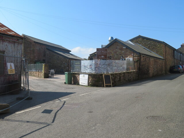
- Milecastle 80 - replaced by Maia Fort (located in Bowness on Solway)
- Maia Fort - no visible surface remains
- Turrets 80a & 80b - possibly existed, but no evidence of the turrets has been found to date; one may possibly have been lost to costal errosion
Scheduled Monument (#1014702): The Roman fort and associated civil settlement and a medieval tower house at Bowness on Solway at the west end of Hadrian's Wall in wall mile 80
Click the headings below to expand (selected extracts from the Historic England scheduling)
Map showing the buried remains of the Roman fort and vicus in this section (Scheduled Monument area).
%
The course of Hadrian's Wall here is thought to have run from Linden House at the east end of the modern village of Bowness to join with the north east corner of the fort. It will have consisted of the Turf Wall which was later replaced by the Stone Wall. Its survival and precise line have however not been confirmed and it is thought that the line of the Wall near the fort has been lost through erosion of the sea cliff. Bainbrigg in 1601 described remains of the wall on the shore west of the fort. The Wall here, would have closed the gap between the north west corner of the fort and the sea at the western end of Hadrian's Wall. This is the equivalent of the spur wall at the east end of the Wall at Wallsend. However its precise location and survival have not been confirmed since.
The exact location of milecastle 80 has not yet been confirmed although it is believed that it survives as a buried feature. On the basis of the usual spacing it is expected to be located below the remains of Bowness fort. However, erosion of the seaward face of the escarpment at Bowness may have removed some of the remains.
The course of the road known as Military Way, which ran along the corridor between the Wall and the vallum linking turrets, milecastles and forts, has not been confirmed at Bowness. However the position of the east gate of the fort has been indicated, from excavations in 1988 by Austen, to coincide with the modern east-west road opposite the house immediately east of the Post Office, and the Military Way is presumed to have entered the fort through this gateway where it is expected to survive as a buried feature. Its precise course approaching the fort has however not yet been confirmed...
The course of the vallum has not yet been confirmed at the western terminus of the Wall, although it may survive as a buried feature. Soil test pits dug in the courtyard of the old rectory in advance of the building of a new rectory in 1988 revealed a feature approximately 2m deep filled with greenish organic material characteristic of the fill of the vallum ditch found elsewhere, although as the edges were not found it is not confirmed that this was in fact the vallum ditch. A geophysical survey in 1991 to the east of the fort was unable to locate the course of the vallum....
Bowness Roman fort, known to the Romans as Maia, is located on a clay knoll rising to 20m above sea level at the west end of the modern village. The perimeter and overall extent of the fort have been determined by excavations since 1930. Unusually on Hadrian's Wall, the fort has its long axis east-west parallel to the course of Hadrian's Wall. Only the forts at Housesteads and Great Chesters are similarly orientated. To the north of the fort lies the Solway Firth with commanding views of the opposing coastline, although the view to the south is restricted by rising ground south of the old rectory.
There are few traces of the fort's remains visible above ground and most of the remains survive as buried features. The south west angle of the fort survives as a slightly raised platform, bounded by the slight hollow reflecting the line of the fort ditches, the outermost of which was recut in the 13th century 15m wide. Excavations by Birley in 1930 and Potter in 1973 confirmed the location of the south and west defences and also confirmed the position of the west gate by locating its north guard chamber immediately north of the modern road. The structures were covered over after the excavations and will survive as buried remains. These excavations established the width of the fort north-south as 128m, while excavations by Austen in 1988 found the eastern defences between the Post Office and High Bank, establishing the east-west length of the fort as 186m. The fort occupies an area 2.38ha, making it the second largest on Hadrian's Wall after the fort at Stanwix.
The north wall of the fort is thought to have been built on the line taken by Hadrian's Wall, but it has been demonstrated by excavations by Birley in 1930 and confirmed by Potter in 1976 that the northern edge of the fort has been lost through erosion of the sea cliff. Little is known of the interior layout other than buildings which were either barracks or stables which were excavated by Potter in 1976 immediately west of the Post Office. The remains were wholly excavated in advance of housing development and no longer survive. These buildings, despite being rebuilt and modified during the period of occupation of the fort, were always of timber construction. This is in contrast to the defences, where the walls, gateways, and interval towers are known from Potter's 1973 and Austen's 1988 excavations to have been initially constructed of turf and timber, but later reconstructed in stone. The bend in the modern road west of the road junction may reflect the position of the headquarters building, known as the principia, which is also likely to have been built in stone.
The extra mural settlement associated with the fort, known as a vicus, is known from excavations and observations of remains exposed during development to have extended round the three landward sides of the fort. Vague traces are visible as low grass covered mounds in the fields on the south and west sides of the village. A sewer trench cut across the field south west of St Michael's Church yielded Roman material including a gold ligula. Observation of building work east of the fort to the south east of Rampart Head by Caruana in 1984 indicated possible remains of the vicus. The full extent of the vicus has not been determined...
The remains of a peel tower were recorded by Leland in 1539 and the same building is again recorded by Auditor King in 1593 as situated at the gate of the old rectory. A local eyewitness in the middle of the 19th century described its destruction at the beginning of that century, noting the massive nature of its foundations. No remains are visible on the surface but the foundations are expected to survive as buried remains.
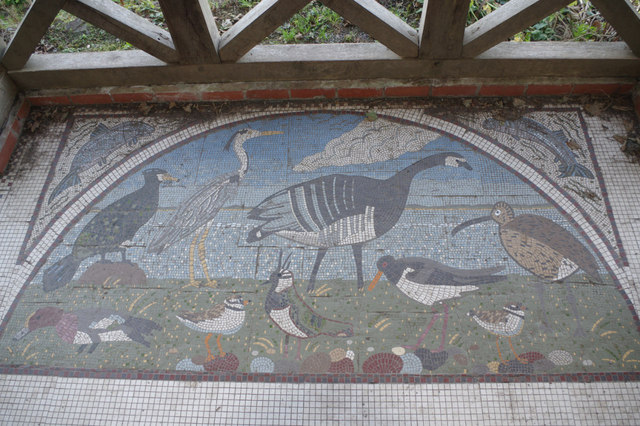
Hadrian's Wall Path is a footpath which runs for 84 miles (135 km), from Wallsend on the East coast of England to Bowness on Solway on the West coast. Most of the route follows close to the line of Hadrian's Wall. Hadrian's Wall Path was designated the 15th National Trail, with an official opening ceremony held on the 23rd May 2003.


from https://historicengland.org.u…
The Roman fort and associated civil settlement and a medieval tower house at Bowness on Solway at the west end of Hadrian's Wall in wall mile 80 - List Entry
- ...The course of Hadrian's Wall here is thought to have run from Linden House at the east end of the modern village of Bowness to join with the north east …
Added by
Simon Cotterill


from https://perlineamvalli.wordpr…
Wall Mile 80
- Wall Mile 80 (August 31, 2011). Mike Bishop's PLV blog about walking Hadrian’s Wall written from an archaeologist’s point of view. "We are first going to head for the bus …
Added by
Simon Cotterill
Co-Curate Page
Hadrian's Wall - Interactive Glossary and Primer
- :root { --bg:#f7f7f8; --card:#ffffff; --text:#1f2937; --muted:#6b7280; --accent:#1f6feb; --border:#e5e7eb; } [data-theme="dark"] { --bg:#0b1220; --card:#111827; --text:#e5e7eb; --muted:#9ca3af; --accent:#60a5fa; --border:#1f2937; } body { margin:0; font-family: system-ui,-apple-system, Segoe UI, Roboto, "Helvetica Neue", Arial, "Noto …
from https://www.heritagegateway.o…
Maia
- Hob Uid: 10116
Location :
Cumbria
Allerdale
Bowness
Grid Ref : NY2227062700
Summary : The site of the Roman fort of Maia at Bowness-on-Solway, part of the Roman defence supporting …
Added by
Simon Cotterill

from https://historicengland.org.u…
The Roman fort and associated civil settlement and a medieval tower house at Bowness on Solway at the west end of Hadrian's Wall in wall mile 80 - List Entry
- ...The course of Hadrian's Wall here is thought to have run from Linden House at the east end of the modern village of Bowness to join with the north east …
Added by
Simon Cotterill
from https://perlineamvalli.wordpr…
Wall Mile 80
- Wall Mile 80 (August 31, 2011). Mike Bishop's PLV blog about walking Hadrian’s Wall written from an archaeologist’s point of view. "We are first going to head for the bus …
Added by
Simon Cotterill
Co-Curate Page
Hadrian's Wall - Interactive Glossary and Primer
- :root { --bg:#f7f7f8; --card:#ffffff; --text:#1f2937; --muted:#6b7280; --accent:#1f6feb; --border:#e5e7eb; } [data-theme="dark"] { --bg:#0b1220; --card:#111827; --text:#e5e7eb; --muted:#9ca3af; --accent:#60a5fa; --border:#1f2937; } body { margin:0; font-family: system-ui,-apple-system, Segoe UI, Roboto, "Helvetica Neue", Arial, "Noto …
from https://www.heritagegateway.o…
Maia
- Hob Uid: 10116
Location :
Cumbria
Allerdale
Bowness
Grid Ref : NY2227062700
Summary : The site of the Roman fort of Maia at Bowness-on-Solway, part of the Roman defence supporting …
Added by
Simon Cotterill


")