Topics > Heritage Sites > Hadrian's Wall > Wall Mile 42
Wall Mile 42
Hadrian's Wall - Wall Mile 42
Hadrian's Wall stretches from the east to west coast of England and was an important frontier of the Roman Empire. Building of the wall began in AD 122 and took six years to complete it’s 84 mile (80 Roman mile) length. Soldiers were garrisoned along the line of the wall in large forts, smaller milecastles, and intervening turrets. The Vallum, a large ditch with mounds on either side, ran along the south side of the wall, protecting the rear of the frontier. Hadrian's Wall was designated as a World Heritage Site in 1987.
Wall Mile 42:
- Milecastle 42 (Cawfields)
- Turret 42a (Burn Head)
- Turret 42b (Great Chesters)
Scheduled Monument (#1010975): Hadrian's Wall and vallum between the road to Caw Gap and the Caw Burn in wall miles 41 and 42
Click the headings below to expand (selected extracts from the Historic England scheduling)
%
The Wall survives well as an upstanding feature throughout the whole of this section, except for where it has been destroyed by Cawfields Quarry in the west. A number of changes in the thickness of the Wall are evidenced as offsets along this section. These may be the product of separate work gangs building up to each other. The Wall is consolidated for 1240m and averages 1.8m to 2.3m in width and 1.2m to 1.6m in height. It reaches a maximum height of 2.8m near Thorny Doors where it is 12 courses high. Both the north and south face are almost complete with only occasional gaps in the outer face.
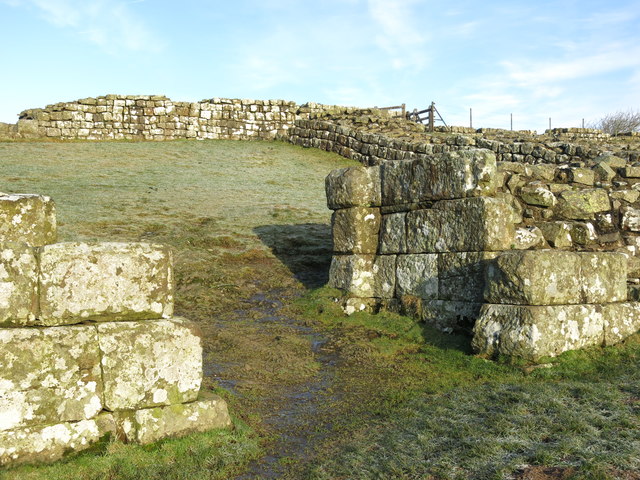
Milecastle 42, or Cawfields, is situated on the crest of Cawfields Crags at the west end and commands wide views in all directions. It survives well as an upstanding stone feature which has been consolidated and is in the care of the Secretary of State. The milecastle straddles a steep south facing slope, 8m to 10m south of the steep north facing crags, and overlooks Hole Gap to the west. The internal dimensions of this milecastle are 17.8m east to west by 14.4m north to south. The walls are 2.8m thick and average 1.4m high. Both gateways of the milecastle are built in massive masonry. Excavations by Clayton in 1848 produced amongst other finds two inscribed stones, one an inscription dedicated to Hadrian and the other a reused tombstone. Further excavations by Simpson took place in 1936.
See our page: Milecastle 42
Turret 42a was located at the west end of Cawfields Crags near to the Caw Burn. However, the large quarry has destroyed the section of Wall, including turret 42a, between Hole Gap and the Caw Burn. The former course of the Wall and position of the turret in this area is however known from the first edition Ordnance Survey map.
The course of the Roman road known as the Military Way, which ran along the corridor between the Wall and the vallum linking the turrets, milecastles and forts is known throughout this section except around Cawfields Quarry where its precise course has not yet been confirmed. It survives as a linear causeway which is most prominent at the east end of this section. Here it measures between 3.5m and 5.2m wide with a revetment containing large stones on the south side and with evidence of a stone kerb.
About 200m east of milecastle 42 and 10m to the south of the Military Way is a fallen Roman milestone. It measures 1.38m high by 0.4m by 0.3m. It is oblong in shape and crudely rounded at the corners. This uninscribed milestone now lies in long grass. Two other milestones from this vicinity have been removed and are now in Chesters museum.
The vallum survives very well in this section as an upstanding turf-covered earthwork. It follows a straight course all through this section. The ditch averages 3m deep with a maximum depth of 3.8m in places. The north and south mounds average 2m in height with a maximum of 2.8m in places. They still follow a very straight course and can be seen to include large boulders in their make up. This is one of the best preserved continuous stretches of vallum.
The remains of a Roman watermill are situated on the east bank of the Caw Burn to the south of the Military Way. It is now covered by the Cawfields Quarry spoil heap and as a result there are no visible remains. Excavation by Simpson in 1907-8 showed that an artificial wood-lined channel had been cut across a bend in the stream and a weir constructed to direct water into it. A rectangular stone building measuring 7m by 4.8m was situated above the channel with its north west wall forming one side of the widened channel. Millstones and pottery were recovered during the excavation which allowed this undershot water mill to be dated to the third century AD. The millstones are now in Chesters museum. The whole complex was surrounded on three sides by a rampart and ditch. It was probably associated with the fort 750m to the west at Great Chesters.
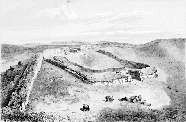
Scheduled Monument (#1010976): Great Chesters Roman fort and Hadrian's Wall between the Caw Burn and the track to Cockmount Hill farm in wall miles 42 and 43
Click the headings below to expand (selected extracts from the Historic England scheduling)
%
Hadrian's Wall survives as a low stony mound throughout much of this section. It is visible as a turf-covered scarp 0.2m high with a modern field wall overlying its course. The farm buildings at Great Chesters east of milecastle 43 partly overlie the Wall in this area. West of Great Chesters fort the course of the narrow wall survives as an amorphous rubble strewn mound 3m to 4.8m wide and 1.1m high. In addition the line of the broad wall here survives as a separate north facing scarp. Excavations here in 1925 revealed that the narrow wall runs south of the broad wall foundation from Great Chesters as far as turret 43a where they converge. Beyond turret 43a they run parallel again as far as Cockmount Hill Wood where their courses again converge. To the west of Burnhead camp a section of unconsolidated exposed Wall, 38m long and 1.8m wide, stands between two to six courses high being up to 1.5m high on the inner face.
The wall ditch survives a visible earthwork throughout most of this section. It averages between 0.8m and 2m in depth with near vertical sides in places. Large boulders protrude from the scarps intermittently along its length.
Turret 42b is situated on a gentle east facing slope to the west of the Caw Burn. It survives as an uneven turf-covered platform, up to 0.6m high. The surface remains show evidence of digging and stone robbing. The turret was first located in 1912 by Simpson. Turret 43a is thought to be situated about 150m east of Cockmount Hill farm. There are quantities of wall debris strewn over the grass-covered bank of the Wall at this location which may obscure any slight surface remains of the turret. The site of the turret was first suggested in 1912 by Simpson, but its position has not yet been verified.
The course of the Roman road known as the Military Way, which ran along the corridor between the Wall and the vallum linking the turrets, milecastles and forts, survives intermittently as an upstanding feature throughout this section. Its course from the Caw Burn is known where it survives as a low turf-covered mound, 6m to 8m wide and 0.2m to 0.5m high. Occasional sections of this low turf-covered causeway reappear on the line up to the east gateway of Great Chesters fort.
The vallum survives as an upstanding earthwork in the west half of this section, but in the east half it is only recognisable as an intermittent mound and ditch and by occasional discolourations in the vegetation. In the west half of the section the north mound averages 0.8m high, the ditch 0.5m to 0.9m deep and the south mound 1.2m high. Here crossings of the vallum are still to be seen at approximately 37m intervals. An excavation trench was cut across the vallum in 1939 by Simpson and Richmond at Cockmount Hill, but the precise location of this trench is not known. It was revealed that a causeway across the vallum was revetted with turves, and that the sides of the ditch had already weathered back prior to the building of the causeway, indicating that the causeway was later.
Co-Curate Page
Hadrian's Wall at Cawfields
- Overview About Milecastle 42 Map Street View The stretch of Hadrian's Wall at Cawfields is one of the highest standing sections of the Wall. The section of wall includes turrets …

from Geograph (geograph)
Part of the remains of Hadrian's Wall near Milecastle 42 at Cawfield
Pinned by Simon Cotterill


Co-Curate Page
Milecastle 42, Hadrian's Wall
- Overview About Milecastle 42 Map Street View Interactive Glossary There are thought to have been 80 milecastles on Hadrian’s Wall, located every Roman mile (1,000 paces) along the Wall, with …

from Geograph (geograph)
(The remains of) Hadrian's Wall east of Aesica (Great Chesters fort)
Pinned by Simon Cotterill


from Geograph (geograph)
Hadrian's Wall between Thorny Doors and Cawfields
Pinned by Simon Cotterill

from Flickr (flickr)
Wall Mile 42 - Milecastle 42 (Cawfields), Hadrian's Wall
Pinned by Simon Cotterill


from Flickr (flickr)
Wall Mile 42 - Milecastle 42 (Cawfields), Hadrian's Wall
Pinned by Simon Cotterill

from https://historicengland.org.u…
Hadrian's Wall and vallum between the road to Caw Gap and the Caw Burn in wall miles 41 and 42
- ....The monument includes the section of Hadrian's Wall and vallum and their associated features between the road to Caw Gap in the east and the Caw Burn in the west. …
Added by
Simon Cotterill
from https://historicengland.org.u…
Great Chesters Roman fort and Hadrian's Wall between the Caw Burn and the track to Cockmount Hill farm in wall miles 42 and 43
- ....Great Chesters Roman fort and Hadrian's Wall between the Caw Burn and the track to Cockmount Hill farm survive well as a series of upstanding and buried remains. Significant information …
Added by
Simon Cotterill

from https://perlineamvalli.wordpr…
Wall Mile 42
- Wall Mile 42 (January 5, 2012). Mike Bishop's PLV blog about walking Hadrian’s Wall written from an archaeologist’s point of view. "...The Trail leaves the eastern site of the fort …
Added by
Simon Cotterill

Co-Curate Page
Hadrian's Wall at Cawfields
- Overview About Milecastle 42 Map Street View The stretch of Hadrian's Wall at Cawfields is one of the highest standing sections of the Wall. The section of wall includes turrets …
from Geograph (geograph)
Part of the remains of Hadrian's Wall near Milecastle 42 at Cawfield
Pinned by Simon Cotterill
Co-Curate Page
Milecastle 42, Hadrian's Wall
- Overview About Milecastle 42 Map Street View Interactive Glossary There are thought to have been 80 milecastles on Hadrian’s Wall, located every Roman mile (1,000 paces) along the Wall, with …
from Geograph (geograph)
(The remains of) Hadrian's Wall east of Aesica (Great Chesters fort)
Pinned by Simon Cotterill
from Geograph (geograph)
Hadrian's Wall between Thorny Doors and Cawfields
Pinned by Simon Cotterill
from Flickr (flickr)
Wall Mile 42 - Milecastle 42 (Cawfields), Hadrian's Wall
Pinned by Simon Cotterill
from Flickr (flickr)
Wall Mile 42 - Milecastle 42 (Cawfields), Hadrian's Wall
Pinned by Simon Cotterill
from https://historicengland.org.u…
Hadrian's Wall and vallum between the road to Caw Gap and the Caw Burn in wall miles 41 and 42
- ....The monument includes the section of Hadrian's Wall and vallum and their associated features between the road to Caw Gap in the east and the Caw Burn in the west. …
Added by
Simon Cotterill
from https://historicengland.org.u…
Great Chesters Roman fort and Hadrian's Wall between the Caw Burn and the track to Cockmount Hill farm in wall miles 42 and 43
- ....Great Chesters Roman fort and Hadrian's Wall between the Caw Burn and the track to Cockmount Hill farm survive well as a series of upstanding and buried remains. Significant information …
Added by
Simon Cotterill
from https://perlineamvalli.wordpr…
Wall Mile 42
- Wall Mile 42 (January 5, 2012). Mike Bishop's PLV blog about walking Hadrian’s Wall written from an archaeologist’s point of view. "...The Trail leaves the eastern site of the fort …
Added by
Simon Cotterill


