Topics > Heritage Sites > Hadrian's Wall > Wall Mile 40
Wall Mile 40
Hadrian's Wall - Wall Mile 40
Hadrian's Wall stretches from the east to west coast of England and was an important frontier of the Roman Empire. Building of the wall began in AD 122 and took six years to complete it’s 84 mile (80 Roman mile) length. Soldiers were garrisoned along the line of the wall in large forts, smaller milecastles, and intervening turrets. The Vallum, a large ditch with mounds on either side, ran along the south side of the wall, protecting the rear of the frontier. Hadrian's Wall was designated as a World Heritage Site in 1987.
Wall Mile 40:
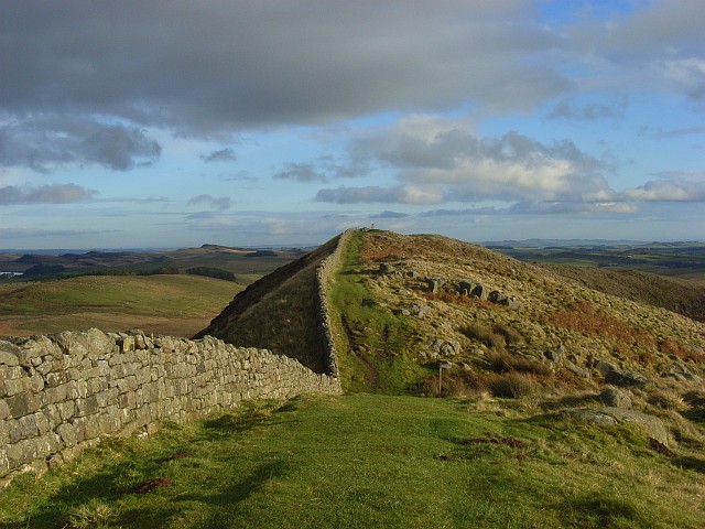
There are well conserved streches of Hadrian's Wall along the ridge of Winshields Crags in Wall Mile 40. The summit of Winshields Crags is the Wall’s highest point, at 345 metres above sea level. The Hadrian's Wall Path national trail and Pennine Way follow the wall along Winshields Crags.
- Milecastle 40 (Winshields) - visible as as turf-covered rubble banks
- Turret 40A (Winshields) - no visible surface remains
- Turret 40B (Melkridge) - no visible surface remains
- Hadrian's Wall at Winshields
Scheduled Monument (#1010973): Hadrian's Wall, associated features and a Romano-British settlement between the road to Steel Rigg car park and the road through Caw Gap in wall miles 39 to 41
Click the headings below to expand (selected extracts from the Historic England scheduling)
%
This section of Wall runs along the crest of the Whin Sill and commands extensive views to the north and south. All the upstanding remains of Hadrian's Wall, the milecastles and the turrets in this scheduling are Listed Grade I. In this section Hadrian's Wall survives intermittently as an upstanding stone wall. It has an average width of 2.2m and the wall face averages 1m high. Sections of wall core still stand up to 1.7m high. A 335m section of upstanding Wall 124m of which has been consolidated on Windshields Crags, including the turf-covered site of milecastle 40, is in the care of the Secretary of State. Elsewhere the Wall survives as a low stony mound with a field wall overlying its course.
The steep crags render a defensive ditch superfluous and so the wall ditch was only constructed in the gaps between the crags. East of Winshields Crags the ditch is visible, surviving between 1.3m and 2.7m deep. The upcast mound from the ditch, usually known as the glacis, measures between 0.3m and 1m high here. In Lodhams Slack the ditch has a maximum depth of 1.8m.
Milecastle 40 is situated to the east of Windshields Crags with wide views to the north, south and east. It survives as an upstanding feature with walls surviving as rubble and turf-covered banks, up to 1m high. The milecastle measures 18.5m north to south by 15m across. Excavations by Simpson in 1908 found the south wall to be standing ten courses high. The excavations also demonstrated that the milecastle had undergone a number of rebuilding episodes. Traces of internal buildings were found in the west half together with an oven discovered in the south east angle.
See our page: Milecastle 40 (winshields)
Turret 40a, which survives as a buried feature, is situated on almost the highest point along Hadrian's Wall. It commands panoramic views in all directions. It was located in 1912 by Simpson. Excavation in 1946 by Stevens showed that it had been deliberately destroyed during the Roman period. It had narrow walls and a doorway in its east side.
Turret 40b is situated on the summit of the hill to the west of Lodhams Slack. This site commands wide views in all directions. It too survives only as a buried feature. It was located in 1912 by Simpson. Excavation in 1946 by Stevens showed that the turret had narrow walls and that it was unusually wide, being 5.85m across internally.
The course of the Roman road known as the Military Way, which ran along the corridor linking turrets, milecastles and forts, is known throughout the length of this section even though for the most part there are few visible remains. Its course is marked usually by a slight causeway, up to 0.2m high, or by differing vegetation marks seen in grass colour. This differentiation in vegetation cover reflects differing growing conditions on the compacted road surface. It is best preserved where it crosses a gully running into Green Slack. Here it survives as a built up causeway, 1.7m high and 2m wide.
Scheduled Monument (#1010974): The vallum between the road to Steel Rigg car park and the road in Caw Gap in wall miles 39, 40 and 41
Click the headings below to expand (selected extracts from the Historic England scheduling)
%
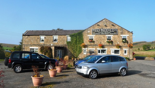
The vallum follows an almost level course throughout this section in the low ground south of Windshields Crags and north of the ridge which carries the Stanegate Roman road. The vallum survives well and is visible as an upstanding earthwork. The ditch averages 1m in depth, while the north and south mounds, which have been substantially reduced, average 0.3m in height. Near Shield on the Wall the ditch has a maximum depth of 2m and the north and south mounds are 1m high. At Twice Brewed the B6318 overlies the vallum, running between the ditch and the southern mound. Parts of the north mound and ditch here have been destroyed by quarrying.
Listed Building, Grade I (#1156389): Hadrian's wall; milecastles 39 and 40; turrets 38A, 38B, 39A, 39B and 40A.
Nearby Roman sites:
Scheduled Monument (#1014820): Vindolanda (Chesterholm) Roman forts, civil settlement and cemeteries, adjacent length of the Stanegate Roman road and two milestones
Scheduled Monument (#1015913): Twice Brewed Roman temporary camp
Scheduled Monument (#1010942): Bean Burn 1 Roman temporary camp
Scheduled Monument (#1010943): Bean Burn 2 Roman temporary camp
Scheduled Monument (#1010940): Seatsides 1 Roman temporary camp and section of the Stanegate Roman road from the west side of the road from Once Brewed to the south side of the B6318
Scheduled Monument (#1010941): Seatsides 2 Roman temporary camp


Co-Curate Page
Hadrian's Wall at Winshields
- The length of Wall at Winshields Craggs is the highest point on Hadrian's Wall.

from https://historicengland.org.u…
Hadrians Wall Milecastles and Turrets
- Hadrian's wall; milecastles 39 and 40; turrets 38A, 38B, 39A, 39B and 40A. AD 122, reconstructed AD 205. Rubble core with dressed stone faces. Course of wall runs west from …
Added by
Simon Cotterill
from https://historicengland.org.u…
Hadrian's Wall, associated features and a Romano-British settlement between the road to Steel Rigg car park and the road through Caw Gap in wall miles 39 to 41 - List Entry
- ....The monument includes the section of Hadrian's Wall and its associated features between the west side of the road to Steel Rigg car park in the east and the west …
Added by
Simon Cotterill
from https://historicengland.org.u…
The vallum between the road to Steel Rigg car park and the road in Caw Gap in wall miles 39, 40 and 41
- ...The monument includes the section of vallum between the west side of the road to Steel Rigg car park in the east and the west side of the road to …
Added by
Simon Cotterill

Co-Curate Page
Hadrian's Wall at Winshields
- The length of Wall at Winshields Craggs is the highest point on Hadrian's Wall.
from https://historicengland.org.u…
Hadrians Wall Milecastles and Turrets
- Hadrian's wall; milecastles 39 and 40; turrets 38A, 38B, 39A, 39B and 40A. AD 122, reconstructed AD 205. Rubble core with dressed stone faces. Course of wall runs west from …
Added by
Simon Cotterill
from https://historicengland.org.u…
Hadrian's Wall, associated features and a Romano-British settlement between the road to Steel Rigg car park and the road through Caw Gap in wall miles 39 to 41 - List Entry
- ....The monument includes the section of Hadrian's Wall and its associated features between the west side of the road to Steel Rigg car park in the east and the west …
Added by
Simon Cotterill
from https://historicengland.org.u…
The vallum between the road to Steel Rigg car park and the road in Caw Gap in wall miles 39, 40 and 41
- ...The monument includes the section of vallum between the west side of the road to Steel Rigg car park in the east and the west side of the road to …
Added by
Simon Cotterill