Topics > Northumberland > Civil Parishes in Northumberland > Henshaw Civil Parish > Historic Buildings and Monuments in Henshaw Civil Parish
Historic Buildings and Monuments in Henshaw Civil Parish
Listed buildings and scheduled monuments in Henshaw Civil Parish, Northumberland, from the National Heritage List for England[1]. Use the Search (below) if looking for a specific building / monument.
| Structure | List No. | Grade | Built~ | Notes |
|---|---|---|---|---|
| Bardon Mill Station Signal Box | 1468393 | II | 1874 | Bardon Mill |
| Barn North-West of Burncliffe | 1045243 | II* | C17th | Tow House |
| Bastle-Type Building North-East of Hillcrest | 1045242 | II | C16th | Tow House |
| Causeway House and Loose Box Adjoining on East | 1045241 | II* | 1770 | |
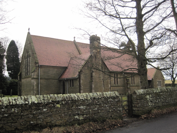
| Church of All Hallows | 1370303 | II | 1889 | Henshaw |
| East Twice Brewed and Adjoining Barn on East | 1045239 | II | 1776 | |
| Former Byre with Granary over South-East of East Twice Brewed | 1045240 | II | C18th | |
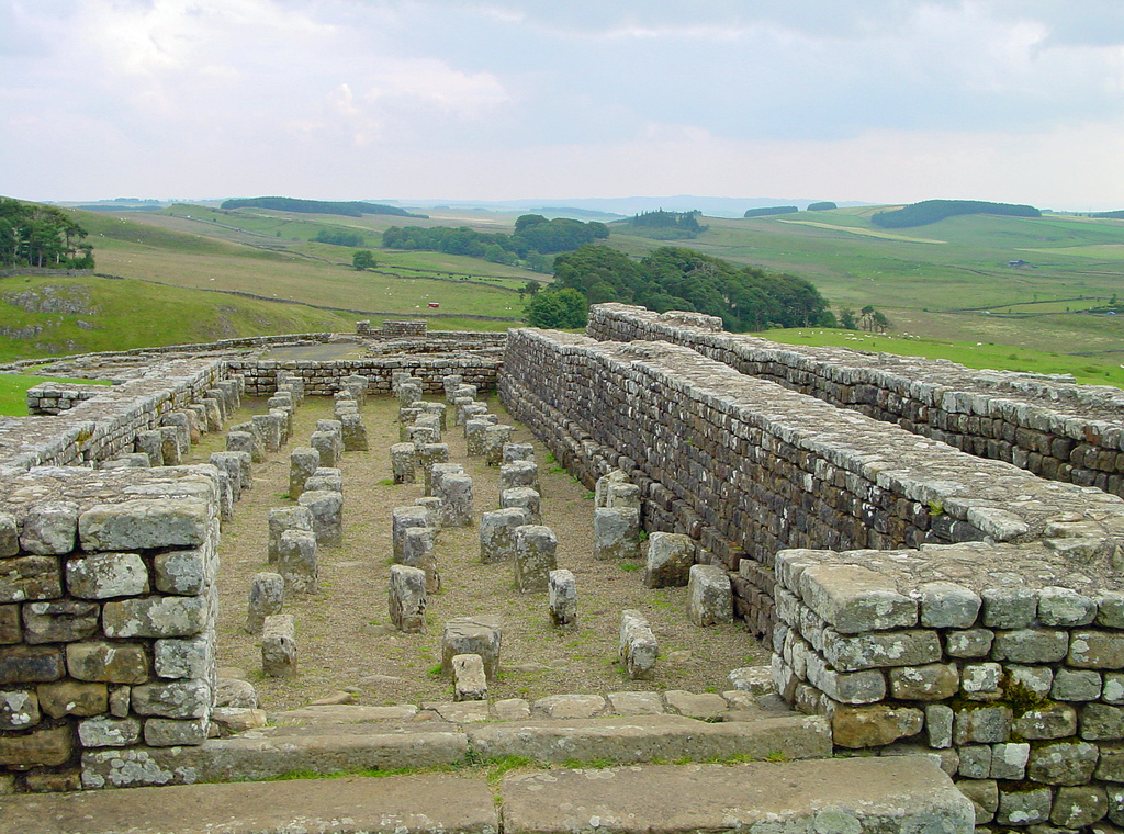
| Hadrians Wall Milecastles and Turrets | 1156389 | I | 122 | Hadrian's wall; milecastles 39 and 40; turrets 38A, 38B, 39A, 39B and 40A. |
| L-Plan Shed and Byre/Loose-Box Ranges East of East Twice Brewed | 1302870 | II | C18th | |
| Ruin of Bastle House 100 Metres East of Stone Hall Farmhouse | 1045238 | II | C16th | |
| The Station House | 1156426 | II | 1836 | Bardon Mill |
| Tower House | 1156436 | II* | C16th | Tow House |
| West Twice Brewed and Barn Adjoining on West | 1156416 | II | C18th | |
| Shieling 290m south west of Benty Sike | 1010030 | n/a | Medieval | Scheduled Monument |
| The easternmost of two shielings on the left bank of Small Burn | 1010031 | n/a | Medieval | Scheduled Monument |
| The westernmost of two shielings on the left bank of Small Burn | 1010032 | n/a | Medieval | Scheduled Monument |
| Shieling at Sundayburn Linn | 1010047 | n/a | Medieval | Scheduled Monument |
| Seatsides 2 Roman temporary camp | 1010941 | n/a | Roman | Scheduled Monument |
| Bean Burn 1 Roman temporary camp | 1010942 | n/a | Roman | Scheduled Monument |
| Bean Burn 2 Roman temporary camp | 1010943 | n/a | Roman | Scheduled Monument |
| Shieling, 670m south west of Spy Crags | 1011827 | n/a | Medieval | Scheduled Monument |
| Shieling, 500m east of Stowerhill Plantation | 1011828 | n/a | Medieval | Scheduled Monument |
| Shieling, 500m south west of Spy Crags | 1011839 | n/a | Medieval | Scheduled Monument |
| Twice Brewed Roman temporary camp | 1015913 | n/a | Roman | Scheduled Monument |
| Round cairn 380m north of Codley Gate | 1018535 | n/a | Bronze Age | Scheduled Monument |
| Enclosed cremation cemetery and shieling 990m north of Gibbs Hill Farm | 1020342 | n/a | Prehistoric | Scheduled Monument |
| Hadrian's Wall, associated features and a Romano-British settlement between the road to Steel Rigg car park and the road through Caw Gap in wall miles 39 to 41 | 1010973 | n/a | Roman | Scheduled Monument |
| The vallum between the road to Steel Rigg car park and the road in Caw Gap in wall miles 39, 40 and 41 | 1010974 | n/a | Roman | Scheduled Monument |
| Seatsides 1 Roman temporary camp and section of the Stanegate Roman road from the west side of the road from Once Brewed to the south side of the B6318 | 1010940 | n/a | Roman | Scheduled Monument |
| Hadrian's Wall and associated features between the field boundary west of turret 37a and the road to Steel Rigg car park in wall miles 37, 38 and 39 | 1010966 | n/a | Roman | Scheduled Monument |
| The vallum and a British settlement between the field boundary west of turret 37a and the road to Steel Rigg car park, in wall miles 37, 38 and 39 | 1010972 | n/a | Roman | Scheduled Monument |
| Vindolanda (Chesterholm) Roman forts, civil settlement and cemeteries, adjacent length of the Stanegate Roman road and two milestones | 1014820 | n/a | Roman | Scheduled Monument |
| Medieval settlement and field system, two bastles and a corn drying kiln, immediately north east of Bradley Hall | 1018533 | n/a | Medieval | Scheduled Monument |
Primary source: the National Heritage List for England - NHLE is the register of nationally protected historic buildings and sites in England, including listed buildings, scheduled monuments, protected wrecks, registered parks and gardens, and battlefields. The list is maintained by Historic England. Check NHLE for updates and new entries. Secondary sources: British Listed Buildings and Keys to the Past.

Co-Curate Page
Tow House Bastle
- There is a 16th century bastle (fortified tower house) in Tow House, near Henshaw, built at a time of hostilities with Scotland and frequent border raids. The building has altered …

Co-Curate Page
Wall Mile 40
- <Mile 39 | Mile 40 | Mile 41> Hadrian's Wall - Wall Mile 40 Hadrian's Wall stretches from the east to west coast of England and was an important frontier …

Co-Curate Page
Milecastle 40 (Winshields)
- Overview Map Aerial View Interactive Glossary Milecastle 40 of Hadrian's Wall is located on Winshields Crags, about ¼mile north of Winshields (farm). It was a Roman fort on Wall Mile …

Co-Curate Page
Bardon Mill Station Signal Box
- The railway signal box to the west of Bardon Mill Station was built in 1874 by the North Eastern Railway

Co-Curate Page
Station House, Bardon Mill
- Overview Map Street View The former station-master's house on Station Road, by Bardon Mill Station is now a private dwelling. It was built in c.1836, with late C19 additions on …

Co-Curate Page
Seatsides 1 Roman temporary camp and section of Stanegate
- Map showing the Scheduled Monument area for the Seatsides 1 temporary camp and section of the Stanegate Roman road. Scheduled Monument (#1010940): Seatsides 1 Roman temporary camp and section of …
Co-Curate Page
Seatsides 2 Roman temporary camp
- Map showing the Scheduled Monument area for Seatsides 2 Roman temporary camp. Scheduled Monument (#1010941): Seatsides 2 Roman temporary camp Click the headings below to expand (selected extracts from the …

Co-Curate Page
Bean Burn 1 Roman temporary camp
- Map showing the Scheduled Monument area of Bean Burn 1 Roman temporary camp. Scheduled Monument (#1010942): Bean Burn 1 Roman temporary camp Click the headings below to expand (selected extracts …
Co-Curate Page
Bean Burn 2 Roman temporary camp
- Map showing the Scheduled Monument area of Bean Burn 2 Roman temporary camp. Scheduled Monument (#1010943): Bean Burn 2 Roman temporary camp Click the headings below to expand (selected extracts …

Co-Curate Page
Tow House Bastle
- There is a 16th century bastle (fortified tower house) in Tow House, near Henshaw, built at a time of hostilities with Scotland and frequent border raids. The building has altered …
Co-Curate Page
Wall Mile 40
- <Mile 39 | Mile 40 | Mile 41> Hadrian's Wall - Wall Mile 40 Hadrian's Wall stretches from the east to west coast of England and was an important frontier …
Co-Curate Page
Milecastle 40 (Winshields)
- Overview Map Aerial View Interactive Glossary Milecastle 40 of Hadrian's Wall is located on Winshields Crags, about ¼mile north of Winshields (farm). It was a Roman fort on Wall Mile …
Co-Curate Page
Bardon Mill Station Signal Box
- The railway signal box to the west of Bardon Mill Station was built in 1874 by the North Eastern Railway
Co-Curate Page
Station House, Bardon Mill
- Overview Map Street View The former station-master's house on Station Road, by Bardon Mill Station is now a private dwelling. It was built in c.1836, with late C19 additions on …
Co-Curate Page
Seatsides 1 Roman temporary camp and section of Stanegate
- Map showing the Scheduled Monument area for the Seatsides 1 temporary camp and section of the Stanegate Roman road. Scheduled Monument (#1010940): Seatsides 1 Roman temporary camp and section of …
Co-Curate Page
Seatsides 2 Roman temporary camp
- Map showing the Scheduled Monument area for Seatsides 2 Roman temporary camp. Scheduled Monument (#1010941): Seatsides 2 Roman temporary camp Click the headings below to expand (selected extracts from the …
Co-Curate Page
Bean Burn 1 Roman temporary camp
- Map showing the Scheduled Monument area of Bean Burn 1 Roman temporary camp. Scheduled Monument (#1010942): Bean Burn 1 Roman temporary camp Click the headings below to expand (selected extracts …


