Topics > Heritage Sites > Hadrian's Wall > Wall Mile 37
Wall Mile 37
Hadrian's Wall - Wall Mile 37
Hadrian's Wall stretches from the east to west coast of England and was an important frontier of the Roman Empire. Building of the wall began in AD 122 and took six years to complete it’s 84 mile (80 Roman mile) length. Soldiers were garrisoned along the line of the wall in large forts, smaller milecastles, and intervening turrets. The Vallum, a large ditch with mounds on either side, ran along the south side of the wall, protecting the rear of the frontier. Hadrian's Wall was designated as a World Heritage Site in 1987.
Wall Mile 37:
- Milecastle 37 - extensive remains
- Turret 37a (Rapishaw Gap) - visible only as a slight earthwork
- Turret 37b (Hotbank Crags) - only just visible as a stone studded platform
Nearby Roman sites:
- Roman signal station on Barcombe Hill by Stanegate (Roman Road), about 1 mile south of Hadrian's Wall
Scheduled Monument (#1018585): Housesteads fort, section of Wall and vallum between the field boundary west of milecastle 36 and the field boundary west of turret 37a in wall miles 36 and 37
Click the headings below to expand (selected extracts from the Historic England scheduling)
%
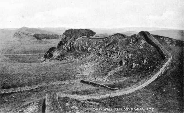
The monument includes Housesteads Roman fort and the section of Hadrian's Wall and vallum and their associated features between the field boundary west of milecastle 36 in the east and the field boundary west of turret 37a in the west. This section occupies the crest and down slope of the escarpment, defined to the north by Housesteads Crags and Cuddy's Crags and to the south by the B6318 road.
Milecastle 37 is situated on the crest of Housesteads Crags with extensive views to the north and south. It is visible as an upstanding structure which has been partly reconstructed and consolidated. The walls have a maximum height of 2.2m internally and the single barrack block in the east half survives to 1m in height. The milecastle was partly excavated between 1988 and 1989 by Crow when it was shown that the north gateway of this milecastle had been deliberately blocked and then later partly demolished.
See our page: Milecastle 37
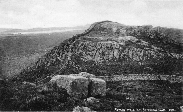
Turret 37a was located on the crest of the scarp on the west side of Rapishaw Gap. It survives as a buried feature beneath a turf cover. The turret was deliberately demolished in an early phase and the Wall was rebuilt across the site.
Scheduled Monument (#1010966): Hadrian's Wall and associated features between the field boundary west of turret 37a and the road to Steel Rigg car park in wall miles 37, 38 and 39
Click the headings below to expand (selected extracts from the Historic England scheduling)
%
Turret 37b is located on the crest of Hotbank Crags with very extensive views in all directions. It survives as a turf-covered platform. The platform measures 6.3m north to south and 10m across and is up to 1.4m high. There is a small enclosure on the east side of the platform which appears to abut both the south side of the Wall and the east side of the turret wall. It could therefore be contemporary with the Wall and may have served as a small stable. It was located in 1911 by Simpson.
The course of the Roman road known as the Military Way, which ran along the corridor between the Wall and the vallum linking turrets, milecastles and forts, survives well as a linear causeway throughout this section. Some stone is visible on the south scarp where it has been built up to make a level surface. This scarp appears to have had a stone revetment. The south scarp averages 0.4m in height, although it reaches up to 1.2m high in places. West of Peel Farm the Military Way is overlain by the road to Steel Rigg car park.
Scheduled Monument (#1010972): The vallum and a British settlement between the field boundary west of turret 37a and the road to Steel Rigg car park, in wall miles 37, 38 and 39
Click the headings below to expand (selected extracts from the Historic England scheduling)
%
The vallum survives well as an upstanding earthwork throughout most of this section. Where extant the north mound averages 1.7m high, the south mound 1m high and the ditch 1.2m deep. Between High Shield and Twice Brewed the B6318 road overlies parts of the vallum. However, where it runs along the line of the vallum the road lies on the south berm, which has resulted in some disturbance to the monument. To the south of Hotbank Crags the remains of the vallum have been reduced and the ditch silted up, though its course can still be traced.


from Flickr (flickr)
The Sixth Legion Victrix Pia Fidelis (built this), Chesters Roman Fort Museum
Pinned by Simon Cotterill

from https://historicengland.org.u…
Housesteads fort, section of Wall and vallum between the field boundary west of milecastle 36 and the field boundary west of turret 37a in wall miles 36 and 37
- ".....The monument includes Housesteads Roman fort and the section of Hadrian's Wall and vallum and their associated features between the field boundary west of milecastle 36 in the east and …
Added by
Simon Cotterill
from https://historicengland.org.u…
Hadrian's Wall and associated features between the field boundary west of turret 37a and the road to Steel Rigg car park in wall miles 37, 38 and 39 - List Entry
- ...Hadrian's Wall and its associated features between the field boundary west of turret 37a and the road to Steel Rigg car park survive well as a series of buried and …
Added by
Simon Cotterill
from https://historicengland.org.u…
The vallum and a British settlement between the field boundary west of turret 37a and the road to Steel Rigg car park, in wall miles 37, 38 and 39 - List Entry
- ...The vallum and associated features, including the British settlement, between the field boundary west of turret 37a and the road to Steel Rigg car park survive well as a series …
Added by
Simon Cotterill

from https://perlineamvalli.wordpr…
Wall Mile 37
- Wall Mile 37 (January 21, 2012). Mike Bishop's PLV blog about walking Hadrian’s Wall written from an archaeologist’s point of view. "...Back on the crags, the Trail takes us 180m …
Added by
Simon Cotterill

from Flickr (flickr)
The Sixth Legion Victrix Pia Fidelis (built this), Chesters Roman Fort Museum
Pinned by Simon Cotterill
from https://historicengland.org.u…
Housesteads fort, section of Wall and vallum between the field boundary west of milecastle 36 and the field boundary west of turret 37a in wall miles 36 and 37
- ".....The monument includes Housesteads Roman fort and the section of Hadrian's Wall and vallum and their associated features between the field boundary west of milecastle 36 in the east and …
Added by
Simon Cotterill
from https://historicengland.org.u…
Hadrian's Wall and associated features between the field boundary west of turret 37a and the road to Steel Rigg car park in wall miles 37, 38 and 39 - List Entry
- ...Hadrian's Wall and its associated features between the field boundary west of turret 37a and the road to Steel Rigg car park survive well as a series of buried and …
Added by
Simon Cotterill
from https://historicengland.org.u…
The vallum and a British settlement between the field boundary west of turret 37a and the road to Steel Rigg car park, in wall miles 37, 38 and 39 - List Entry
- ...The vallum and associated features, including the British settlement, between the field boundary west of turret 37a and the road to Steel Rigg car park survive well as a series …
Added by
Simon Cotterill
from https://perlineamvalli.wordpr…
Wall Mile 37
- Wall Mile 37 (January 21, 2012). Mike Bishop's PLV blog about walking Hadrian’s Wall written from an archaeologist’s point of view. "...Back on the crags, the Trail takes us 180m …
Added by
Simon Cotterill


