Topics > Heritage Sites > Hadrian's Wall > Wall Mile 36
Wall Mile 36
Hadrian's Wall - Wall Mile 36
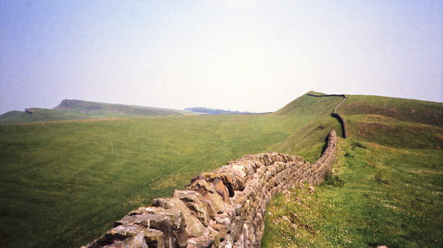
Hadrian's Wall stretches from the east to west coast of England and was an important frontier of the Roman Empire. Building of the wall began in AD 122 and took six years to complete it's 84 mile (80 Roman mile) length. Soldiers were garrisoned along the line of the wall in large forts, smaller milecastles, and intervening turrets. The Vallum, a large ditch with mounds on either side, ran along the south side of the wall, protecting the rear of the frontier. Hadrian's Wall was designated as a World Heritage Site in 1987.
Wall Mile 36:
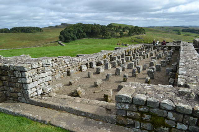
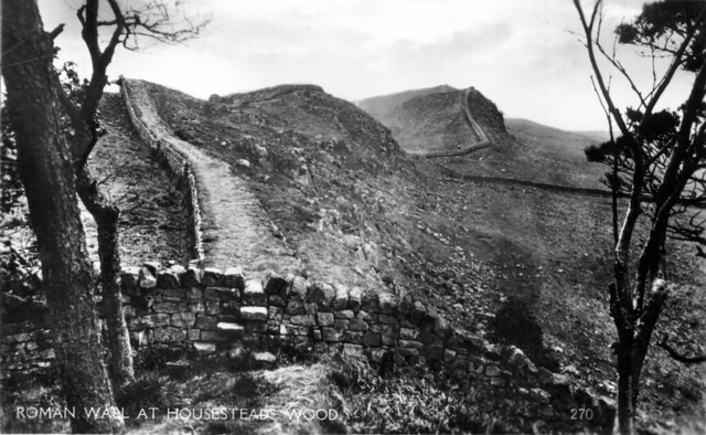
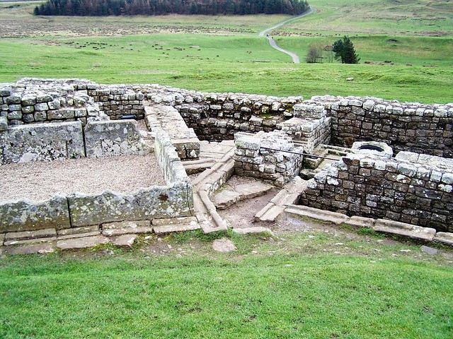
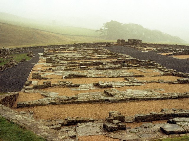
Wall Mile 36 has some of the best conserved continuous sections of the wall. It includes Housesteads, which is one of the best preserved forts on Hadrian's Wall, built around 124 AD. The fort covers an area of approximately 5 acres, and was garrisoned by around 1,000 infantry. There is a museum on the site, including Roman artefacts from the fort.
- Milecastle 36 (King's Hill) - few surface remains, largely destroyed by surface quarrying and stone robbing.
- Turret 36a (Kennel Crags) - visible only as a slight earthen platform
- Knag Burn Gate - gateway through the wall east of Housesteads
- Housesteads Fort
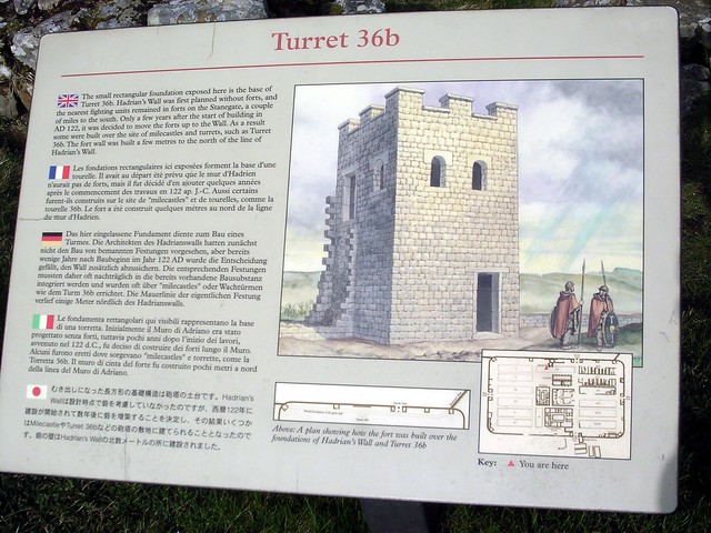
- Turret 36b (Housesteads) - demolished when Housteads fort was built in c. AD 124
Scheduled Monument (#1010964): Hadrian's Wall and associated features between the boundary east of turret 34a and the field boundary west of milecastle 36 in wall miles 34, 35 and 36
Click the headings below to expand (selected extracts from the Historic England scheduling)
%
The Wall survives intermittently as an upstanding feature throughout this section.
At Busy Gap a section of ditch was cut which survives as a feature, 12m wide and up to 1.2m deep. West of milecastle 36 another shorter section of ditch was cut, now measuring 2.1m in depth and 10m in width. To the north of the Wall, at the foot of Kings Hill crags is a narrow linear earthwork, up to 7m wide which has been identified as a prehistoric field boundary.
Milecastle 36 occupies the summit of Kings Hill. It survives as a turf-covered feature. The east and west walls are indicated by robber trenches up to 0.5m deep. The featureless interior of the milecastle is overlain by stone which has tumbled onto it from the adjacent Wall. The milecastle was excavated during 1946 and was found to have narrow walls. The north gate had been reconstructed in a post-Hadrianic period, probably around AD 180. The south gate had been destroyed.
Branch roads survive linking the Military Way with the south gates of both milecastles 35 and 36. At milecastle 35 the low, uneven turf-covered mound of the causeway is up to 5.5m wide and 0.2m high. At milecastle 36 the turf- covered causeway is up to 4m wide and 0.3m high.
Scheduled Monument (#1018585): Housesteads fort, section of Wall and vallum between the field boundary west of milecastle 36 and the field boundary west of turret 37a in wall miles 36 and 37
Click the headings below to expand (selected extracts from the Historic England scheduling)
%
The monument includes Housesteads Roman fort and the section of Hadrian's Wall and vallum and their associated features between the field boundary west of milecastle 36 in the east and the field boundary west of turret 37a in the west. This section occupies the crest and down slope of the escarpment, defined to the north by Housesteads Crags and Cuddy's Crags and to the south by the B6318 road.
Throughout most of this section Hadrian's Wall survives as an upstanding feature. To the east of the fort a 320m section of the Wall is consolidated....Between milecastle 36 and the stretch of consolidated Wall, the Wall survives as a turf-covered mound overlain on its north face by a modern field wall made from reused Roman masonry.
West of Housesteads to Rapishaw Gap the well-preserved remains of the Wall have been consolidated. At Rapishaw Gap itself the Wall has been mostly robbed out and a modern field wall overlies its south face. Beyond Rapishaw Gap the Wall again survives as a consolidated upstanding feature. The wall ditch was only constructed in the short gaps between the steep crags. On Clew Hill the 35m section of ditch is up to 13m wide and 2m deep with tumbled Roman masonry from the Wall in its base.
Between Housesteads Crags and Cuddy's Crags the ditch is visible though it is prone to silting and water-logging. Possible remains of the ditch upcast, known as the 'glacis', survives to the north of the ditch as an amorphous spread of material covered by turf. At Rapishaw Gap the ditch is heavily silted and overgrown with rushes, though it is still visible to a depth of 1.3m. A modern trackway truncates the west end of this ditch.
To the east of the fort a 320m section of the Wall is consolidated and in the care of the Secretary of State. Within this stretch of consolidated Wall there is a gateway, 3.7m wide, at the low point of the Knag Burn. Possibly used by civil rather than military traffic, it consists of a single passage flanked by guard chambers on either side. Pivot holes at back and front show that there were two sets of doors.
See our page: Knag Burn Gate
Turret 36a, located in 1911, occupies the crest of Kennel Crags. It is visible as an irregular turf-covered platform measuring 17m north east by 6m south west, and up to 1.1m high. No internal features are visible and it is partly overlain by stone which has tumbled onto it from the adjacent Wall. Excavations during 1946 showed that the turret had narrow walls and a door in the east side.
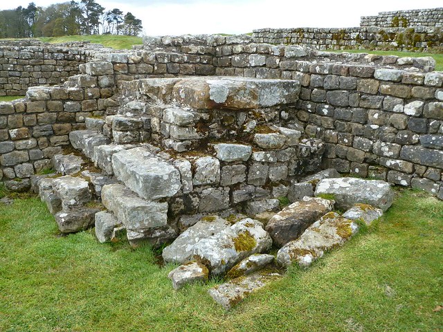
Turret 36b was built before Housesteads fort, occupying part of the crest of Housesteads Crags later overlain by the fort. The foundation courses of the turret have been exposed by excavations within Housesteads fort. It survives as an upstanding structure which has been consolidated and is in the care of the Secretary of State as part of the fort.
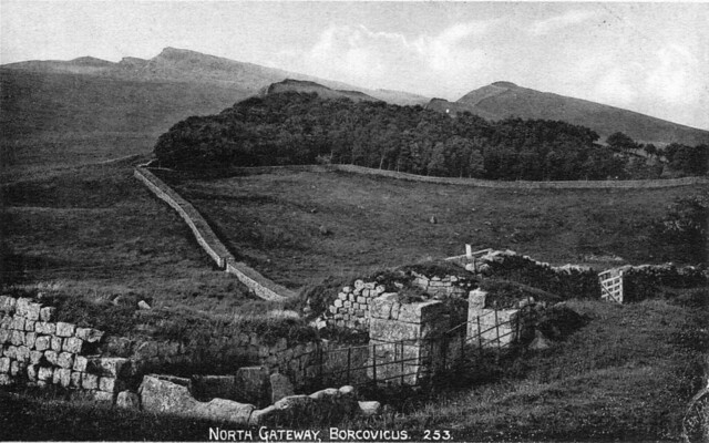
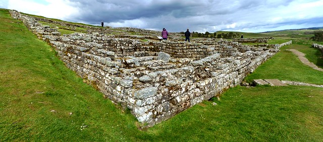
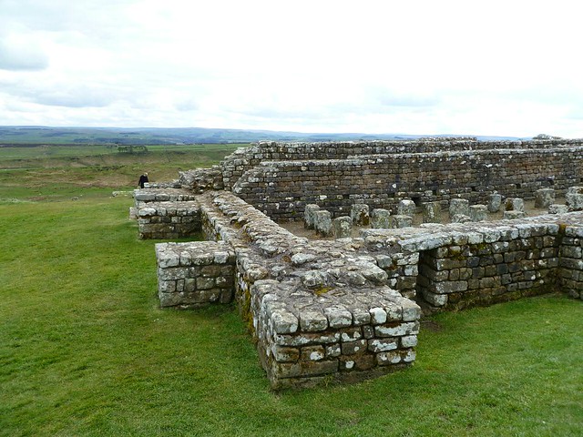
The Roman fort at Housesteads, known to the Romans as Vercovicium, occupies the prominent crest of the Whin Sill escarpment to the west of the Knag Burn. It commands wide views to the north and south, being one of the most dramatic and best preserved Roman sites in Britain. It is unusual among the Wall forts for having an east-west orientation rather than a north-south one. This is due to the constraints imposed by the topography.
The fort covers an area of approximately 2ha and accommodated a cohort between 800 and 1,000 strong, being later reinforced by a cavalry unit. Its remains survive well as upstanding masonry and earthworks and buried features. The walls and gateways of the fort are exposed and consolidated.
A number of the interior buildings are also exposed and consolidated including the headquarters building, the commanding officer's house, a hospital, granaries, barracks, workshops and a latrine. The fort is in the care of the Secretary of State.
The fort was added to the Wall after the broad wall foundations and turret 36b were built, but before the narrow wall (which was eventually constructed on the broad wall foundations) was constructed up to the fort.
On the west side of the fort, north of the Military Way, there is a series of mounds, up to 0.8m high, forming small rectangular paddocks. These may have accommodated the horses associated with the cavalry unit known to have been stationed at the fort in its later phases.
The earliest activity on the site is evidenced by a Bronze Age pot found beneath one of the barracks, which had probably come from a ridge top burial cairn. Post-Roman activity on the fort site is evidenced by a bastle house which was built partly over the west tower of the south gateway. There has been a history of excavations on the fort from 1822 up to 1988.
See our pages: Housesteads
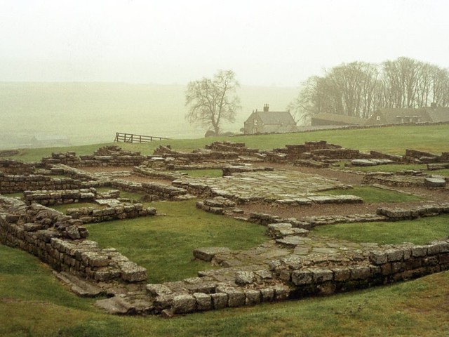
The civil settlement outside the fort [Housesteads], usually referred to as a vicus, is very extensive stretching for at least 200m south of the fort. It also clustered around the east and west sides of the fort. In its initial phase the vicus was situated to the south of the vallum. However, by the third century AD at the latest the vallum was levelled and the vicus was moved up the hill and constructed immediately adjacent to the fort. To the south of the fort over 20 buildings were excavated during the 1930s, although only six remain on view as upstanding buildings with consolidated stone walls. They are believed to be the foundations of a group of shops and/or taverns. Outside the fort's east gate small robber trenches demarcate the ground plans of some of the vicus buildings.
Aerial photographs show that the remains of the vicus around Housesteads covered an area at least as large as that of the fort itself. Excavation has shown that the settlement dates, in its most developed form, to the third and fourth centuries AD. An inscription indicates that this vicus had its own local government.
Beyond the vicus to the south and west there is a series of cultivation terraces running along the contours in a roughly east-west direction. They survive as upstanding earthworks and can be seen to directly overlie the vallum. These terraces are themselves overlain in parts by strip fields and early ridge and furrow cultivation. On the basis of these relationships the terraces are considered to be of Roman date and are probably associated with the vicus settlement.
The Housesteads bath house was positioned to the east of the fort on a rock shelf on the slope on the east side of the Knag Burn. Its disturbed remains survive as turf-covered undulations. Investigations have shown that it was heated by hypocausts, soot being found in the flues. Nearer the Wall is a spring cased in Roman masonry, which probably supplied the baths with water.
The location of two cemeteries at Housesteads fort and vicus are known, surviving as buried features below the turf cover. There is one cemetery situated to the west of the fort, south of the Military Way. Another is known to lie either side of Chapel Hill. To the south of Chapel Hill a number of tombstones have been found including one commemorating a medical officer named Anicius Ingenuus. In the low ground to the east of Chapel Hill human remains have been found during drainage works. These finds suggest the cemetery around Chapel Hill was extensive.
The remains of a temple to the Persian god Mithras is located beyond the west end of Chapel Hill, close to where a spring flows. This half underground temple was located in 1822. It survives as a series of turf-covered features, some of which are visible as slight earthworks. Excavations in 1898 revealed a long nave, flanked on either side by benches for the accommodation of worshippers. Beyond this was the sanctuary which contained an elaborate relief carving of Mithras surrounded by the zodiac, together with several altars and statues to two lesser deities.
The remains of a temple to the Germanic god `Mars Thincsus' is located to the north of Chapel Hill. A well found during excavation has been consolidated and can be seen on the ground. The other remains survive as buried features. Excavations during 1961 revealed the foundations of a circular shrine, 4m in diameter. Pottery recovered from the interior dated the structure to the third century AD.
Other finds included an elaborately carved arched door head and inscribed stones dedicated to `Mars Thincsus'. The shrine was found to overlie part of the vicus settlement when it was situated to the south of the vallum. A series of temples are known from building inscriptions to have been located on Chapel Hill itself. Their remains survive as buried features. Several altars have been found here dedicated to Jupiter and the Spirit of the Deified Emperors, indicating that the official state cult was practised here.
The Roman road known as the Military Way, which ran along the corridor between the Wall and the vallum linking the turrets, milecastles and forts, survives as a turf-covered linear mound throughout most of this section. West of Housesteads Plantation the mound is well-preserved, up to 6.6m wide in places. East of Housesteads Plantation the mound is 4m wide and 0.8m high on its south side.
The Military Way crosses the Knag Burn by a double dog-leg and enters the east gate of the fort between the buildings of the extra mural settlement. West of the fort the Military Way is visible as a linear mound with an often indistinct north side. It averages between 3.3m and 6m in width. The south side is revetted by a line of boulders up to 0.6m high. The road is turf- covered with some cobbling visible in places. The approach to the west gate of the fort is blocked by two or three banks which seem to be late defences of the fourth century AD.
Branch roads leading from the Military Way proper to turret 36a, milecastle 37 and turret 37a are visible in places as slight level mounds. Elsewhere their course is indicated by differing vegetation marks seen in grass colour. This differentiation in vegetation cover reflects differing growing conditions on the compacted road surface. An earlier Roman road runs from the north side of the vallum south of King's Hill westwards towards Housesteads where it is overlain by the Military Way at NY7925 6997. It survives as a turf-covered linear mound up to 6.5m wide and 0.9m high. Some metalling is visible through the turf.
East of the fort the vallum survives as an upstanding earthwork. The north and south mounds have been reduced and spread by agriculture, though the ditch is up to 1.5m deep. West of the Knag Burn there is little surface trace of the vallum as it was levelled when the settlement outside the fort developed and was built over it. To the west of the fort the remains of the vallum are not obvious. However, parallel cultivation terraces and occasional banks up to 1m high denote its course. The ditch is completely silted up in this stretch.
To the north east of Housesteads fort, and at the foot of the crags on which the Wall is located, a number of medieval shielings have been identified. These were used seasonally by shepherds controlling summer grazing on open lands to the north. Additionally a linear earthwork, identified as a prehistoric field boundary has been identified as well as Roman quarries. Two circular earthworks, one known as the Fairy Stones, may be of prehistoric or medieval date, although their function is not yet fully understood.
Scheduled Monument (#1010965): The vallum and early Roman road between the field boundary east of turret 34a and the field boundary west of milecastle 36 in wall miles 34, 35 and 36
Click the headings below to expand (selected extracts from the Historic England scheduling)
%
The vallum survives as a series of upstanding earthworks throughout this section. The north mound of the vallum has been reduced by pasture improvement, though it still averages 1m in height. A number of low points in the mound throughout its course denote crossings over the vallum. The south mound averages about 1.2m in height, but in places it is overlain and partly obliterated by a modern field wall. The vallum ditch is well preserved, averaging 2m in depth.
The causeway of an early Roman road is located running parallel to the vallum on its north side opposite Moss Kennels. It is visible as a turf-covered mound, averaging 8m wide and 0.4m high for approximately 400m throughout the western part of this monument. Further east it has been reduced by ploughing and is no longer visible as an upstanding earthwork, although buried remains will survive beneath the present ground surface. It has a level surface with some of the metalling exposed.
Co-Curate Page
Housesteads
- Overview About Howsteads Fort Map Street View Interactive Glossary Housesteads (Roman name: "Vercovicium") is one of the best preserved forts on Hadrian's Wall, built around 124 AD. The fort covers …


from Flickr (flickr)
Hadrian's Wall, Hotbank Crags, heading towards Milecastle 37 and Housesteads Roman Fort
Pinned by Simon Cotterill

from Flickr (flickr)
Statue of Cautes from Housesteads, Chesters Roman Fort Museum
Pinned by Simon Cotterill

from https://historicengland.org.u…
Hadrian's Wall and associated features between the boundary east of turret 34a and the field boundary west of milecastle 36 in wall miles 34, 35 and 36
- ....The monument includes the section of Hadrian's Wall and its associated features between the field boundary east of turret 34a in the east and the field boundary west of milecastle …
Added by
Simon Cotterill
from https://historicengland.org.u…
The vallum and early Roman road between the field boundary east of turret 34a and the field boundary west of milecastle 36 in wall miles 34, 35 and 36 - List Entry
- ....The vallum and its associated features including the Roman road between the field boundary east of turret 34a and the field boundary west of milecastle 36 survive well as a …
Added by
Simon Cotterill
from https://historicengland.org.u…
Housesteads fort, section of Wall and vallum between the field boundary west of milecastle 36 and the field boundary west of turret 37a in wall miles 36 and 37
- ".....The monument includes Housesteads Roman fort and the section of Hadrian's Wall and vallum and their associated features between the field boundary west of milecastle 36 in the east and …
Added by
Simon Cotterill

from https://perlineamvalli.wordpr…
Wall Mile 36
- Wall Mile 36 (January 28, 2012). Mike Bishop's PLV blog about walking Hadrian’s Wall written from an archaeologist’s point of view. "....Housesteads is the best-known and most popular Roman fort …
Added by
Simon Cotterill

Co-Curate Page
Housesteads
- Overview About Howsteads Fort Map Street View Interactive Glossary Housesteads (Roman name: "Vercovicium") is one of the best preserved forts on Hadrian's Wall, built around 124 AD. The fort covers …
from Flickr (flickr)
Hadrian's Wall, Hotbank Crags, heading towards Milecastle 37 and Housesteads Roman Fort
Pinned by Simon Cotterill
from Flickr (flickr)
Statue of Cautes from Housesteads, Chesters Roman Fort Museum
Pinned by Simon Cotterill
from https://historicengland.org.u…
Hadrian's Wall and associated features between the boundary east of turret 34a and the field boundary west of milecastle 36 in wall miles 34, 35 and 36
- ....The monument includes the section of Hadrian's Wall and its associated features between the field boundary east of turret 34a in the east and the field boundary west of milecastle …
Added by
Simon Cotterill
from https://historicengland.org.u…
The vallum and early Roman road between the field boundary east of turret 34a and the field boundary west of milecastle 36 in wall miles 34, 35 and 36 - List Entry
- ....The vallum and its associated features including the Roman road between the field boundary east of turret 34a and the field boundary west of milecastle 36 survive well as a …
Added by
Simon Cotterill
from https://historicengland.org.u…
Housesteads fort, section of Wall and vallum between the field boundary west of milecastle 36 and the field boundary west of turret 37a in wall miles 36 and 37
- ".....The monument includes Housesteads Roman fort and the section of Hadrian's Wall and vallum and their associated features between the field boundary west of milecastle 36 in the east and …
Added by
Simon Cotterill
from https://perlineamvalli.wordpr…
Wall Mile 36
- Wall Mile 36 (January 28, 2012). Mike Bishop's PLV blog about walking Hadrian’s Wall written from an archaeologist’s point of view. "....Housesteads is the best-known and most popular Roman fort …
Added by
Simon Cotterill


