Topics > Heritage Sites > Hadrian's Wall > Wall Mile 26
Wall Mile 26
Hadrian's Wall - Wall Mile 26
Hadrian's Wall stretches from the east to west coast of England and was an important frontier of the Roman Empire. Building of the wall began in AD 122 and took six years to complete it’s 84 mile (80 Roman mile) length. Soldiers were garrisoned along the line of the wall in large forts, smaller milecastles, and intervening turrets. The Vallum, a large ditch with mounds on either side, ran along the south side of the wall, protecting the rear of the frontier. Hadrian's Wall was designated as a World Heritage Site in 1987.
Wall Mile 26:
- Milecastle 26 (Planetrees) - no visible surface remains.
- Turret 26a (High Brunton) -
- Turret 26b (Brunton) - significant remains
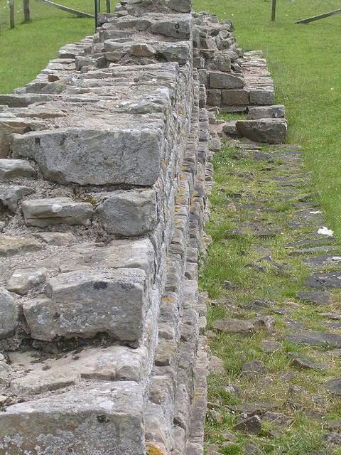
A surviving 49 ft section of the Wall, known as Planetrees Roman Wall, is a significant example of a change of policy by the Romans, during the construction of the Wall. It has the "Narrow Wall" width, but was built on wider "Broad Wall" foundations.
Scheduled Monument (#1018581): Hadrian's Wall and vallum between St Oswald's Cottages, east of Brunton Gate and the North Tyne in wall miles 25, 26 and 27
Click the headings below to expand (selected extracts from the Historic England scheduling)
Map showing Scheduled Monument area (Historic England data), with additional markers.
%
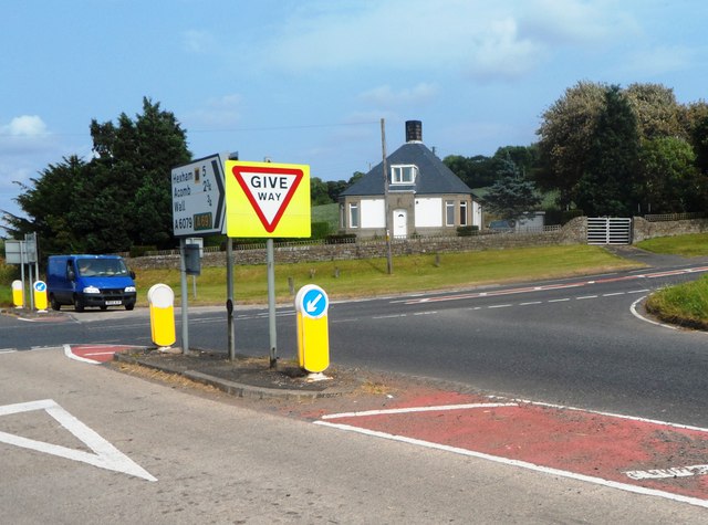
The monument includes the stretch of Hadrian's Wall, vallum and associated features between St Oswald's Cottages, east of Brunton Gate in the east and the River North Tyne in the west. This section occupies the west-facing side of the North Tyne valley. Hadrian's Wall bends slightly northwards at Dixon's Plantation and then follows a straight alignment all the way down to the crossing of the North Tyne. The B6318 road runs to the north of the Wall line for most of this section.
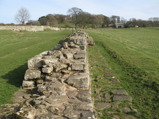
The Wall is visible as an upstanding monument only in parts of this section. There is a 35m stretch of consolidated wall showing the junction between broad wall and narrow wall, at Planetrees, which is in the care of the Secretary of State. A second stretch of consolidated wall, 69m long and including turret 26b, is visible west of Brunton House. This is also in the care of the Secretary of State. Finally a further section of the Wall about 100m long, from the disused railway to the bridge abutment is in the care of the Secretary of State. Elsewhere throughout this section the Wall survives as a buried feature beneath grassland and dense woodland.
The outer ditch is visible intermittently as a well-preserved earthwork. It is best preserved in the areas of woodland where it reaches depths of 3.5m.
Milecastle 26, or `Planetrees' survives as a buried feature, partly beneath the B6318 and the areas to the north and south of it opposite Planetrees Farm. Milecastle 26 was partly excavated during 1930 by Hepple.
The site of turret 26a was located opposite High Brunton House during 1930 by Hepple. It is situated on a steep east-facing slope. It survives as a buried feature below the dense woodland on the south side of the B6318. It was partly excavated during 1959 when it was shown to have had two levels of occupation, with no finds later than the second century AD.
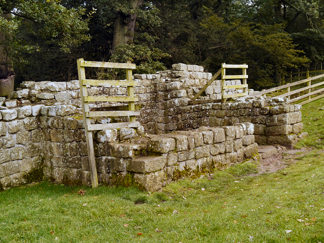
Turret 26b is a well-preserved upstanding example of a turret, up to 2.8m high. It is situated on a stretch of consolidated wall; both the Wall and turret are in the care of the Secretary of State. On the east side of the turret the broad wall wing of the turret is joined by a section of narrow wall, indicating that the turrets were built first and the Wall was then built up to them. This turret was first excavated by Clayton during 1873 and later by Hepple in 1930.
The course of the Roman road known as the Military Way, which ran along the corridor between the Wall and the vallum linking turrets, milecastles and forts, is considered to be on the line of the north mound of the vallum in this section. Throughout this section the north mound of the vallum has been largely levelled by ploughing and so it is doubtful whether the Military Way survives intact here. The exception to this is where the angle of descent down to the North Tyne is particularly steep opposite Black Pasture Cottage, and here a turf-covered trackway leaves the line of the north mound to run down the side of a dry valley to rejoin it some 180m further on. This diversion effectively eases the gradient. Where the valley opens out this track is visible as a raised causeway 7m wide and 0.2m high.
The vallum has been disturbed by ploughing in this section and for most of its length the mounds have been ploughed flat and the ditch only survives as a buried feature, now silted up. Intermittent sections of upstanding earthworks occur, the best preserved being to the west of Brunton Gate where the north mound survives up to 1.6m high and the ditch up to 1.7m deep.
A cemetery, probably associated with the Roman fort at Chesters, exists alongside the probable course of the Military Way as it approaches the river crossing of the North Tyne on its east side. Excavation works for the building of the now disused North Tyne railway in 1857 uncovered human bone, a burial urn and fragments of samian ware Roman pottery. Layers of burnt material were found underneath the line of the vallum mounds. This positive relationship between Roman cemeteries and approach roads to forts is becoming increasingly apparent, being evidenced elsewhere along the Wall at Great Chesters, Carvoran and Carrawburgh.


from Flickr (flickr)
Wall Mile 26 - Milecastle 26 (location), Hadrian's Wall
Pinned by Simon Cotterill

from https://historicengland.org.u…
Hadrian's Wall and vallum between St Oswald's Cottages, east of Brunton Gate and the North Tyne in wall miles 25, 26 and 27 - List Entry
- ".....The monument includes the stretch of Hadrian's Wall, vallum and associated features between St Oswald's Cottages, east of Brunton Gate in the east and the River North Tyne in the …
Added by
Simon Cotterill
Co-Curate Page
Planetrees Roman Wall
- Overview About Planetrees Wall Map Street View Planetrees is an extant section of Hadrian's Wall named after the farm located around 250 metres (270 yd) to the west. The …

from Flickr (flickr)
Wall Mile 26 - Milecastle 26 (location), Hadrian's Wall
Pinned by Simon Cotterill
from https://historicengland.org.u…
Hadrian's Wall and vallum between St Oswald's Cottages, east of Brunton Gate and the North Tyne in wall miles 25, 26 and 27 - List Entry
- ".....The monument includes the stretch of Hadrian's Wall, vallum and associated features between St Oswald's Cottages, east of Brunton Gate in the east and the River North Tyne in the …
Added by
Simon Cotterill
Co-Curate Page
Planetrees Roman Wall
- Overview About Planetrees Wall Map Street View Planetrees is an extant section of Hadrian's Wall named after the farm located around 250 metres (270 yd) to the west. The …