Topics > Northumberland > Great Tosson > Tosson Burgh univallate hillfort
Tosson Burgh univallate hillfort
Scheduled Monument area - based on Historic England data (Open Government Licence) - to the west of Great Tosson.

LIDAR - Image from opendata.hillforts.eu (CC-BY-SA), based on data from the Environment Agency - National LIDAR programme.
Tosson Burgh is a Late Bronze Age to Early Iron Age hillfort, situated on a prominent knoll west of Great Tosson in Northumberland. It commands panoramic views over the Coquet valley. It is a univallate hillfort, meaning it has a single rampart. The north and west sides are naturally protected by steep, defensive slopes. On the more vulnerable south and eastern sides, the oval-shaped fort has a well-defined external ditch. The site is a Scheduled Monument (legally protected).
Scheduled Monument (#1011267): Tosson Burgh univallate hillfort, 450m west of Great Tosson
Click the headings below to expand (selected extracts from the Historic England scheduling)
The hillfort on Burgh Hill survives well and will retain extensive archaeological remains. It is one of several hillforts overlooking the River Coquet and it will contribute to any study of later prehistoric settlement and activity along this river valley.
The monument includes a hillfort of Iron Age date situated on the top of a prominent hill commanding extensive views of the Coquet valley to the north, west and east. The situation has been carefully chosen, occupying a knoll which is naturally defended on the northern and western sides by steep slopes. The enclosure is oval in shape and measures 100m east-west by 45m north-south within a single rampart, and on some sides a ditch. Slight traces of the rampart are visible on the northern side but on the better preserved south and south-western sides it survives to a height of 2m above the bottom of the ditch. The rampart has apparently been built up from the insides, in places giving the appearance of an internal ditch. On the vulnerable south and eastern sides there is a shallow ditch; the natural steep slope of the ground made this precaution unnecessary elsewhere.
The main entrance is clearly visible on the southern side as a break in the ditch and a fine staggered rampart which is very well preserved. A well defined hollow way is visible leading westwards from the entrance. A gap in the western defences 2.5m across may represent another entrance and a slight lowering of the rampart at the eastern end of the enclosure with an apparent causeway across the ditch may be an original eastern entrance. There are no visible traces of internal huts or yards within the interior but they survive as buried features beneath ground level. Several prehistoric finds were reputedly found on the hillside in the late 19th and early 20th centuries including a bronze axe found on the enclosure by a workman in 1890.
Tosson Burgh, Northumberland (#EN0595)
Click the headings below to expand (selected extracts from the Atlas of Hillforts of Britain and Ireland)
Lying 450m to the W of Great Tosson, an oval univallate hillfort of approximately 0.43ha. The site lies at 228m OD on the summit of a knoll at the N end of a promontory. The Coquet valley surrounds the promontory to the N, E and W. The enclosure measures 100m E-W by 45m N-S with a single rampart which was possibly formed by scarping the natural slopes from the inside, evidenced by the presence of a slight internal ditch. An external ditch up to 10m wide is visible on the S and SE sides where the rampart survives to a height of 2m above the bottom of the ditch. An entrance lies in the S where there is a break in the ditch and a staggered rampart with the SE terminal of the rampart curving slightly inwards. A holloway leads westwards from this entrance. A further 2.5m wide gap in the ramparts in the W and a causeway across the ditch and a lowering of the ramparts in the E might be further entrances. There is no visible evidence for internal occupation. Prehistoric finds are said to have been found on the hillside in the late 19th and early 20th centuries and a bronze axe was discovered within the enclosure by a workman in 1890, but no further information is available. Ploughing has occurred across the hillfort in the medieval or post medieval periods. The site is recorded on 1856-65 OS mapping and scheduled in 1932. It is undated but presumed iron Age.
Source: Lock, Gary and Ralston, Ian. 2024. Atlas of Hillforts of Britain and Ireland. Available at: https://hillforts.arch.ox.ac.uk (CC BY-SA 4.0)
from https://www.geograph.org.uk/p…
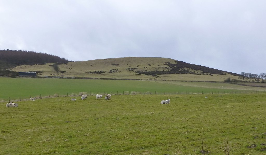
Burgh Hill with its fort
- The hillfort at Tosson Burgh occupies a carefully chosen naturally defended site overlooking the Coquet valley to the north, west and east. Photo by Russel Wills, 15 April, 2013, Geograph, …
Added by
Simon Cotterill

from https://www.geograph.org.uk/p…
Burgh Hill with its fort
- The hillfort at Tosson Burgh occupies a carefully chosen naturally defended site overlooking the Coquet valley to the north, west and east. Photo by Russel Wills, 15 April, 2013, Geograph, …
Added by
Simon Cotterill