Topics > Northumberland > Civil Parishes in Northumberland > Morpeth Town Council Area
Morpeth Town Council Area
Area: 9.0 km²
Population:
14,378 (2021 Census)
14,017 (2011 Census)
13,833 (2001 Census)
Co-Curate Page
Morpeth
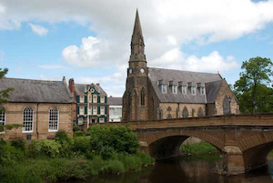
- Overview About Morpeth Map Street View The county town of Northumberland. Help build the Morpeth Timeline Morpeth is a town in the north-east of England, lying on the River Wansbeck. …

Co-Curate Page
Morpeth, Historical Account, 1848
- MORPETH (St. Mary), a parish, a borough, and the head of a union, partly in the E. and partly in the W. division of Castle ward, S. division, and partly …

Co-Curate Page
Morpeth
- Overview About Morpeth Map Street View The county town of Northumberland. Help build the Morpeth Timeline Morpeth is a town in the north-east of England, lying on the River Wansbeck. …


