Topics > Tyne and Wear > Sunderland > Monkwearmouth > Monkwearmouth Parish, 1848
Monkwearmouth Parish, 1848
WEARMOUTH, MONK (St. Peter), a parish, in the union of Sunderland, E. division of Chester ward, N. division of the county of Durham; containing, with the district parish of Southwick, and the townships of Monk-Wearmouth-Shore, Fulwell, and Hylton, 12,493 inhabitants, of whom 2,155 are in Monk-Wearmouth township, ½ a mile (N.) from Sunderland. This place derives its name Wearmouth from its situation at the mouth of the river Wear, and the prefix Monk from the foundation of a Benedictine monastery about the year 674, by Biscopius, a Saxon noble, who obtained from Egfrid, King of Northumbria, a grant of land near the river, for the erection of the abbey, which he dedicated to St. Peter. In the reign of Ethelred, the monastery was destroyed by the Danes, and though subsequently restored, the greater number of the monks, among whom was the Venerable Bede, remained in the abbey of Jarrow, erected by the same founder, into which they had retired. A few only returned to Monk-Wearmouth, which afterwards became a cell to the monastery of St. Cuthbert, in the city of Durham, and remained as such till the Dissolution, when its revenue was returned at £26. 9. 9. Of the church, which was splendidly decorated with paintings, and relics brought by its founder from Rome, the nave and tower, with a few scattered details, are still remaining; but the other conventual buildings, which, about the middle of the last century, occupied three sides of a large quadrangle, have entirely disappeared.
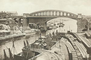
The town is situated on the north bank of the Wear, opposite to Sunderland and Bishop-Wearmouth, with which it is connected by a beautiful iron bridge; and comprises two distinct portions, called Upper and Lower, the former in the township of Monk-Wearmouth, and the latter in that of Monk-Wearmouth-Shore. The upper town has a long and spacious street, extending from east to west, parallel with which is a narrower street, both intersected by several streets of recent formation connecting it on the south with the lower town; on the west is the Newcastle turnpike-road. The lower town, which originally consisted of a few fishermen's huts, and, till within the last twenty years, of three narrow streets extending along the shore, has been greatly improved by the erection of some streets of handsome houses, under the more liberal leases granted by the proprietor, Sir Hedworth Williamson, Bart. It contains by far the greater portion of the population. Public baths have been erected by a company, with several commodious lodging-houses, and a good hotel for visiters, forming together a handsome terrace overlooking the sea.
The principal manufactures carried on are those of rope, blocks, masts, chain-cables and anchors, and other articles connected with ship and boat building, for which there are large yards. The chief trade of the port is the exportation of coal and lime, from the collieries and lime-works in the neighbourhood, to Aberdeen, Montrose, Arbroath, and other Scottish ports; of the former, about 30,000 chaldrons are annually shipped, and of the latter about 70,000, exclusively of 20,000 chaldrons of lime consumed in the surrounding districts. Large quantities also of blue, white, and brown earthenware, for which there are extensive potteries in the villages of Southwick and Hylton, are shipped for France, Holland, and Germany. For the conveyance of the produce of the mines and potteries to the port, great facility is afforded by the river, which is navigable for vessels of light burthen for several miles above the town. The Brandling Junction railway, which has a branch leading to the docks, connects the towns of Sunderland, Bishop and Monk Wearmouth, South Shields, and Newcastle, and opens a communication with the Carlisle railway, and, southwards, with the Clarence, Darlington and Stockton, and York railways. The docks, situated about 350 yards from the mouth of the river, comprise an outer basin about an acre and a half in extent, having an entrance from the river 120 feet in width, and surrounded on all sides with massive walls of freestone. This basin has, in ordinary tides, from 12 to 18 feet depth of water; and communicates, by a floodgate 45 feet wide, with an inner dock to the north, which is six acres and a half in extent, with an average depth of 16 feet, and in which 100 vessels may lie in safety. These docks were completed in 1837.
The parish comprises an area of 5,196 acres, of which 547a. 2r. 24p. are in the township of Monk-Wearmouth, and 250 acres inMonk-Wearmouth-Shore. The surface is almost uniformly level, and from the small proportion of woodland and plantations, the scenery is but little varied, and has few interesting features. The lands are well cultivated, and produce favourable crops; the soil in the west and south-west parts is a strong clay, and in the eastern portion an argillaceous loam, resting on a substratum of magnesian limestone, which prevails throughout the neighbourhood. About half a mile west of the town is one of the deepest and most scientifically formed coal-mines in the kingdom, belonging to Messrs. Pemberton and Company, and affording a striking example of enterprise and unwearied perseverance. The main shaft, which is of cylindrical form, 12 feet in diameter, and 264 fathoms in depth, was commenced in 1826, and completed in 1836; and in order, by proper ventilation, to guard against accidents, a second shaft has been sunk, partly perpendicular, and partly diverging in a diagonal line to the seam of coal. To the northwest of the town are the extensive lime quarries and kilns of Fulwell, belonging to Sir Hedworth Williamson, at which about 9000 chaldrons of lime are annually produced, and conveyed by an iron railway to the staiths on the river.
The living is a perpetual curacy, in the patronage of Sir H. Williamson. The tithes of the township of MonkWearmouth have been commuted for £215. 16. 6. The church, originally that of the monastery, retains but little of its ancient splendour: the tower, of Norman character, supported on four massive circular arches, the nave, and the north aisle, are alone remaining, the rest having long since been destroyed; the interior has undergone many alterations and repairs, and is chiefly modern. A church district named All Saints' has been endowed by the Ecclesiastical Commissioners; patrons, the Crown and the Bishop of Durham, alternately. There are places of worship for Baptists, Independents, Primitive and Wesleyan Methodists, members of the Church of Scotland, and Seceders.
Extract from: A Topographical Dictionary of England comprising the several counties, cities, boroughs, corporate and market towns, parishes, and townships..... 7th Edition, by Samuel Lewis, London, 1848.

from https://openlibrary.org/books…
A topographical dictionary of England, Samuel Lewis, 7th Ed., 1848
- A topographical dictionary of England
comprising the several counties, cities, boroughs, corporate and market towns, parishes, and townships, and the islands of Guernsey, Jersey, and Man, with historical and statistical …
Added by
Simon Cotterill
Co-Curate Page
Bishopwearmouth Parish, 1848
- WEARMOUTH, BISHOP (St. Michael), a parish, partly in the union of Houghton-le-Spring, but chiefly in that of Sunderland, N. division of Easington ward and of the county of Durham, 11 …
Co-Curate Page
Fulwell, 1848
- FULWELL, a township, in the parish of MonkWearmouth, union of Sunderland, E. division of Chester ward, N. division of the county of Durham, 2 miles (N.N.W.) from Sunderland; containing 134 …
Co-Curate Page
Southwick, Sunderland, 1848
- SOUTHWICK (Holy Trinity), a district parish, in the union of Sunderland; E. division of Chester ward, N. division of the county of Durham, 1¾ mile (N.W. by W.) from Sunderland; …

from https://openlibrary.org/books…
A topographical dictionary of England, Samuel Lewis, 7th Ed., 1848
- A topographical dictionary of England
comprising the several counties, cities, boroughs, corporate and market towns, parishes, and townships, and the islands of Guernsey, Jersey, and Man, with historical and statistical …
Added by
Simon Cotterill
Co-Curate Page
Bishopwearmouth Parish, 1848
- WEARMOUTH, BISHOP (St. Michael), a parish, partly in the union of Houghton-le-Spring, but chiefly in that of Sunderland, N. division of Easington ward and of the county of Durham, 11 …
Co-Curate Page
Fulwell, 1848
- FULWELL, a township, in the parish of MonkWearmouth, union of Sunderland, E. division of Chester ward, N. division of the county of Durham, 2 miles (N.N.W.) from Sunderland; containing 134 …