Topics > Civil Parishes in Cumbria > Patterdale Civil Parish > Historic Buildings and Monuments in Patterdale Parish
Historic Buildings and Monuments in Patterdale Parish
About the Parish. Listed buildings and scheduled monuments:
| Structure | List No. | Grade | Built~ | Locality | Note |
|---|---|---|---|---|---|
| Bank End | 1245321 | II | C17th | Hartsop | |
| Beck Side | 1245319 | II | C17th | Hartsop | |
| Broadhow Wordsworth Cottage | 1245325 | II | C17th | Rooking | |
| Brothersfield Cottage | 1271923 | II | C16th | Hartsop | |
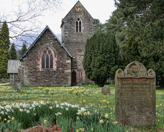
| Church of St Patrick | 1404461 | II | 1853 | Patterdale | Designed by Anthony Salvin |
| Caudale Beck Farmhouse | 1245314 | II | C17th | ||
| Chamberlaine Cottage | 1245316 | II | C17th | Hartsop | |
| Corn Drying Kiln in Field at Rear of How Green Farmhouse | 1271922 | II | C16/17th | Hartsop | |
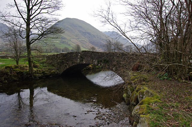
| Cow Bridge | 1271942 | II | C17th | Nr. Hartsop | Packhorse bridge (widened) |
| Crook-A-Beck crookbeck Farmhouse | 1245326 | II | C17th | ||
| Dalehead | 1245317 | II | C17th | Hartsop | |
| Deepdale Cottage at Deepdale Bridge | 1245288 | II | C18th | ||
| Deepdale Hall | 1245310 | II | C17th | ||
| Eagle Farmhouse | 1271911 | II | c.1635 | Glenridding | |
| Elmhow with Attached Cart Sheds | 1245333 | II | C17th | ||
| Farm Buildings Attached to Glencoyne glencoyne | 1245329 | II* | C17th | ||
| Fell Yeat | 1245320 | II | C16th | Hartsop | |
| Glenridding House | 1245312 | II | Glenridding | ||
| Grassthwaitehow | 1245313 | II | C17th | Grisdale | |
| Hartsop Hall and Farm Buildings Attached to Hartsop Hall | 1245315 | I | C16th | Hartsop | |
| High Beckside | 1245324 | II | C17th | Hartsop | |
| Hoghouse | 1413918 | II | C19th | ||
| How Green Farmhouse; Farm Buildings Attached to How Green Farmhouse | 1245323 | II | C17th | Hartsop | |
| K6 Telephone Kiosk | 1367183 | II | 1935 | Nr. Hartsop | |
| Lane Head | 1271939 | II | C16 | Lane Head | |
| Low House with Attached Farm Buildings | 1271877 | II | C17th | Hartsop | |
| Mireside | 1245318 | II | C17th | Hartsop | |
| Moss Side with Attached Barn | 1245308 | II | C18th | Deepdale | |
| Parsey House with Attached Barn | 1245322 | II | C17th | Hartsop | |
| Pasture Beck Bridge | 1271921 | II | C17th | Hartsop | |
| Patterdale Hall (With Attached Gatehouse and Stable Wing) | 1245393 | II | C17th | Patterdale | |
| Prehistoric rock art in Patterdale 40m north west of Beckstones | 1019435 | n/a | Scheduled Monument | ||
| Prehistoric rock art in Patterdale 270m north west of Crookabeck | 1019436 | n/a | Scheduled Monument | ||
| Prehistoric rock art at Place Fell Cottage, 370m north east of Goldrill Bridge | 1019438 | n/a | Scheduled Monument | ||
| Prehistoric rock art at Green Rigg, 310m north east of Goldrill bridge | 1019437 | n/a | Scheduled Monument | ||
| Myers Head lead mine | 1015652 | n/a | 1870s | nr. Hartsop | Scheduled Monument |
| Rattlebeck Cottage | 1271941 | II | C17th | Glenridding | |
| The How Cottage with Associated Farmbuildings | 1054609 | II | C17th | Hartsop | |
| Thorn House | 1245392 | II | C17th | Hartsop | |
| Top Power House electric power generation station and associated leat for Greenside lead mine centred 740m NNW of Hole-in-the-Wall | 1021144 | n/a | Scheduled Monument | ||
| Romano-British enclosed stone hut circle settlement and round cairn 350m south of Hartsop Hall | 1011359 | n/a | Scheduled Monument | ||
| Hogget Gill lead smelting mill, water management system and wood drying kiln | 1015653 | n/a | Scheduled Monument | ||
| Greenside lead mines, ore works and smelt mill | 1015654 | n/a | Scheduled Monument | ||
| High Street, Roman road | 1003275 | n/a | Scheduled Monument | ||
| Wall End Farmhouse with Attached Barn | 1245311 | II | 1630s | ||
| Wallend Bridge | 1271940 | II | C17th | ||
| Yew Tree Cottage at Deepdale Bridge | 1245287 | II | C18th | ||
| Hartsop Conservation Area | - | n/a | Conservation Area |
Co-Curate Page
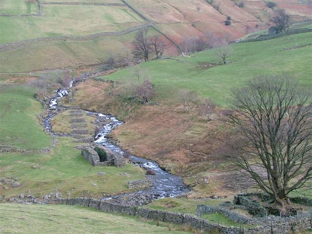
Myers Head Lead Mine
- The remains of Myers Head Lead Mine are located by the confluence of Pasture Beck and Hayeswater Gill, south-east of Hartsop in the Eden district of Cumbria.


