Topics > Civil Parishes in Cumbria > Barton and Pooley Bridge Civil Parish > Historic Buildings and Monuments in Barton Civil Parish
Historic Buildings and Monuments in Barton Civil Parish
Listed buildings and scheduled monuments in Barton Civil Parish, Cumbria, from the National Heritage List for England[1]. Use the Search (below) if looking for a specific building / monument.
| Structure | List No. | Grade | Built~ | Notes |
|---|---|---|---|---|
| Barn Immediately North of Mains Farmhouse | 1326810 | II | ||
| Barn Immediately to North West of Elderbeck | 1337664 | II | ||
| Barton Church Farmhouse | 1145234 | II* | ||
| Barton Hall | 1145227 | II | ||
| Boundary Post | 1145235 | II | ||
| Boundary Post at NY 450 210 | 1145264 | II | ||
| Brewsher Monument Approximately 5.5 Metres to South of St Michael's Church | 1145231 | II | ||
| Celleron Cottage | 1336952 | II | ||
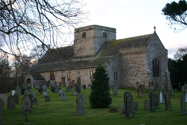
| Church of St Michael | 1326830 | I | C12th | |
| Cross Dormont Farmhouse and Attached Barn | 1123710 | II | ||
| Elderbeck and Cottage | 1145265 | II | ||
| Farm Building Immediately to Southwest of Mains Farmhouse | 1111764 | II | ||
| Glasson Monument Approximately 10 Metres to North East of St Michael's Church | 1145229 | II | ||
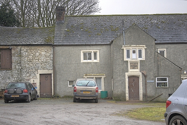
| Glebe Farmhouse | 1336948 | II* | 1637 | |
| High Brow | 1336939 | II | ||
| Kirkbarrow | 1145268 | II | ||
| Limekiln Approximately 60 Metres East of Winder Hall Cottage | 1145237 | II | ||
| Low Brown Farmhouse | 1145236 | II | ||
| Mains Farmhouse | 1110846 | II | ||
| Moorend Farmhouse and Attached Outbuildings | 1326809 | II | ||
| Mounting Block Immediately to North of Church of St Michael | 1145228 | II | ||
| Nicholson Monument Approximately 3.5 Metres to South of St Michael's Church | 1326832 | II | ||
| Nicholson Monument Approximately 6 Metres to South of St Michael's Church | 1326833 | II | ||
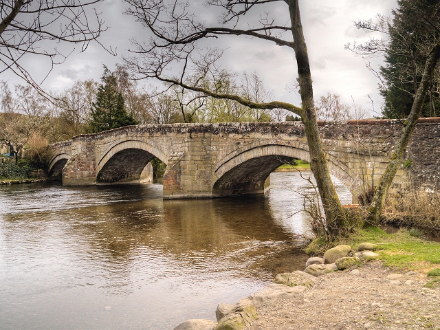
| 1145267 | II | 1764 | Destroyed by Storm Desmond in 2015 | |
| Range of Farm Buildings Attached to Barton Church Farmhouse | 1336950 | II | ||
| Roehead and Attached Outbuildings | 1337463 | II | ||
| Rowan Monument Approximately 13.5 Metres South of St Michaels Church | 1111779 | II | ||
| Seat Farmhouse, Cottage and Attached Barn | 1145266 | II | ||
| Sisson Monument Approx 17.5 Metres Approximately to South of St Michael's Church | 1145233 | II | ||
| Speight Monument Approximately 11.5 Metres to South of St Michaels Church | 1145230 | II | ||
| Suder Monument Approximately 17 Metres to South of St Michael's Church | 1145232 | II | ||
| Todd Monument Approximately 7 Metres South of St Michael's Church (Qv) | 1111778 | II | ||
| Todd Monument immediately to south of chancel of Church of St Michael | 1326831 | II | ||
| Walker Monument Approximately 9 Metres South of St Michaels Church | 1326834 | II | ||
| Waterside House | 1124186 | II | ||
| Winder Hall | 1111902 | II | ||
| Winder Hall Cottage and Barn | 1326836 | II | ||
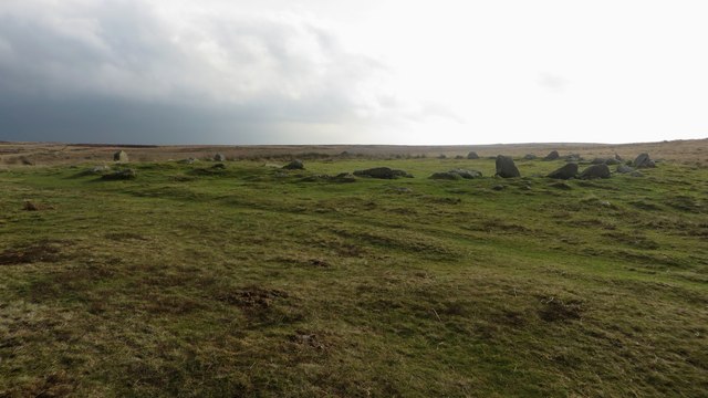
| Small stone circle on Swarth Fell | 1007357 | n/a | Scheduled Monument | |
| The Cockpit stone circle and seven adjacent clearance cairns, Moor Divock | 1007367 | n/a | Scheduled Monument | |
| Two round cairns 415m and 420m NNE of The Cockpit, Moor Divock | 1007372 | n/a | Scheduled Monument | |
| Moated site and annexe south of Gale Bay | 1007405 | n/a | Scheduled Monument | |
| Four funerary cairns and a surrounding cairnfield on Threepow Raise | 1007356 | n/a | Scheduled Monument | |
| Round cairn on Heughscar Hill | 1011589 | n/a | Scheduled Monument | |
| High Street, Roman road | 1003275 | n/a | Scheduled Monument | |
| Dalemain (park) | 1000663 | II* | Listed Park and Garden |
Primary source: the National Heritage List for England - NHLE is the register of nationally protected historic buildings and sites in England, including listed buildings, scheduled monuments, protected wrecks, registered parks and gardens, and battlefields. The list is maintained by Historic England. Check NHLE for updates and new entries.
Secondary sources: British Listed Buildings.
Co-Curate Page
Church of St Michael, Barton
- Overview About St Michael's Church Map Street View St Michael's Church is in the parish of Barton, Cumbria, England. It is an active Anglican parish church in the deanery …
Co-Curate Page
Glebe Farmhouse, Barton
- Overview Map Street View Glebe Farmhouse in Barton, Cumbria, was originally the rectory for St Michael's Church. It was built in 1637 for the Rev L. Dawes. A panel above …
Co-Curate Page
Bridge (1764 - 2015), Pooley Bridge
- The old stone bridge over the River Eamont at Pooley Bridge, built in 1764, was washed away by floodwater following 'Storm Desmond' on the 6th of December 2015. A temporary …

Co-Curate Page
Church of St Michael, Barton
- Overview About St Michael's Church Map Street View St Michael's Church is in the parish of Barton, Cumbria, England. It is an active Anglican parish church in the deanery …
Co-Curate Page
Glebe Farmhouse, Barton
- Overview Map Street View Glebe Farmhouse in Barton, Cumbria, was originally the rectory for St Michael's Church. It was built in 1637 for the Rev L. Dawes. A panel above …


