Topics > Northumberland > Civil Parishes in Northumberland > Bardon Mill Civil Parish > Historic Buildings and Monuments in Bardon Mill Civil Parish
Historic Buildings and Monuments in Bardon Mill Civil Parish
Listed buildings and scheduled monuments in Bardon Mill Civil Parish, Northumberland, from the National Heritage List for England[1]. Use the Search (below) if looking for a specific building / monument.
| Structure | List No. | Grade | Built~ | Notes |
|---|---|---|---|---|
| Barn, byres and stable, 20m north of High Meadow House | 1042526 | II* | C18th | |
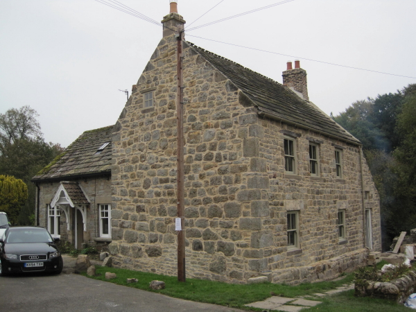
| Beltingham House | 1042533 | II | C18th | Beltingham |
| Church of St Cuthbert | 1370817 | I | C15th | Beltingham |
| Churchyard Cross 4 Metres East of North East Corner of Parish Church | 1042532 | II | C13th | Partial cross head |
| Crow Hall Farmhouse and Adjacent Farm Buildings | 1042531 | II | c1770 | A69 |
| Garage/Workshop Adjacent to West End of Garden Cottage at Millhouse Grange | 1042494 | II | C16th | Bardon Mill, Bastle |
| Gatepiers Wall and Railings South of Beltingham House | 1154290 | II | C18th | Beltingham |
| Grandys Knowe Farmhouse and Adjacent Ruined Bastle to West | 1370839 | II | C16th | |
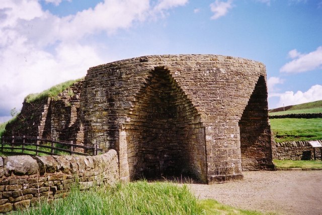
| Limekiln on East Side of Road 200 Metres South West of West Crinkledikes Farmhouse | 1042493 | II | C19th | |
| Millhouse Grange | 1370840 | II | ||
| Old Mill | 1042495 | II | ||
| Outbuilding 15 Metres North of Birkshaw House | 1042492 | II | ||
| Outbuilding 50 Metres South West of Penpeugh Farmhouse | 1042529 | II | ||
| Outbuilding to North-East of Hill House | 1154353 | II | ||
| Partridge Nest Farmhouse | 1042527 | II | C18th | |
| Penpeugh Farmhouse | 1042528 | II | ||
| Ridley Bastle | 1370841 | II | Ridley | |
| Ridley Bridge | 1042496 | II* | 1793 | Ridley |
| Ridley Hall | 1370842 | II | 1743 | Ridley |
| Shankhead Farmhouse and Attached Barn | 1042530 | II | C17th | |
| Shankhead Lower Farmhouse | 1370816 | II | 1764 | |
| Table Tomb 2.5 Metres East of the South East Corner of the Parish Church | 1370818 | II | C18th | Beltingham |
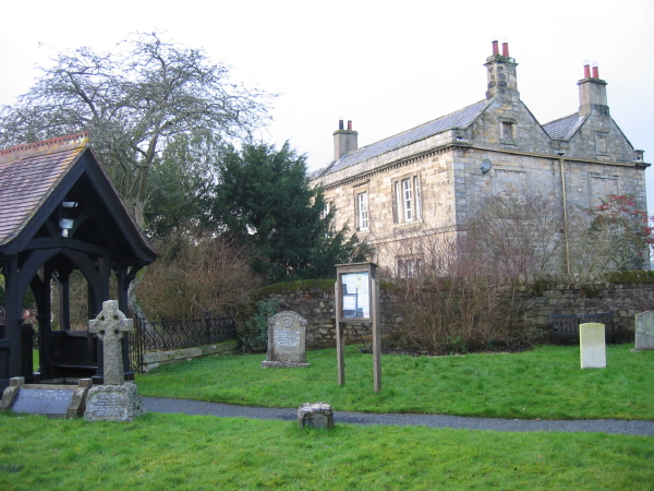
| The Vicarage | 1042491 | II | 1845 | Beltingham |
| War Memorial | 1391492 | II | 1920 | Bardon Mill |
| White Heather Cottage | 1370838 | II | C16th | Beltingham. Former bastle. |
| Willimontswick Farmhouse | 1042497 | II* | C16th | Willimontswick. Manor house; rebuilt c1900 |
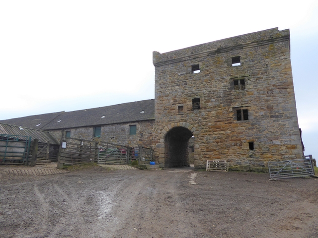
| Willimontswick Gatehouse and Adjacent Ranges | 1370843 | I | C16th | With later alterations |
| Willimontswyke (uninhabited portions) | 1006516 | n/a | Scheduled Monument | |
| Three prehistoric and Romano-British settlements and associated cord rig at Green Brae | 1016469 | n/a | Scheduled Monument | |
| Bastle at Grandy's Knowe | 1016812 | n/a | C16th | Scheduled Monument |
| Roman quarry inscription on Queen's Crags, 680m south east of East Hotbank | 1017958 | n/a | Roman | Scheduled Monument |
| Stone circle, defended settlement, Romano-British farmstead and field system, Roman camp and group of shielings immediately south of Greenlee Lough | 1017961 | n/a | Scheduled Monument | |
| Bowl barrow 420m south west of New Beggarbog | 1018531 | n/a | Scheduled Monument | |
| Prehistoric settlement 230m north of Bradley | 1018532 | n/a | Scheduled Monument | |
| Round cairn 450m north east of East Crindledikes | 1018534 | n/a | Scheduled Monument | |
| Defended settlement and Roman signal station 410m south of West Crindledikes | 1018536 | n/a | Iron Age | Scheduled Monument |
| Hadrian's Wall and associated features between the field boundary west of turret 37a and the road to Steel Rigg car park in wall miles 37, 38 and 39 | 1010966 | n/a | Roman | Scheduled Monument |
| The vallum and a British settlement between the field boundary west of turret 37a and the road to Steel Rigg car park, in wall miles 37, 38 and 39 | 1010972 | n/a | Roman | Scheduled Monument |
| Vindolanda (Chesterholm) Roman forts, civil settlement and cemeteries, adjacent length of the Stanegate Roman road and two milestones | 1014820 | n/a | Roman | Scheduled Monument. Partly in this parish. |
| Medieval settlement and field system, two bastles and a corn drying kiln, immediately north east of Bradley Hall | 1018533 | n/a | Scheduled Monument | |
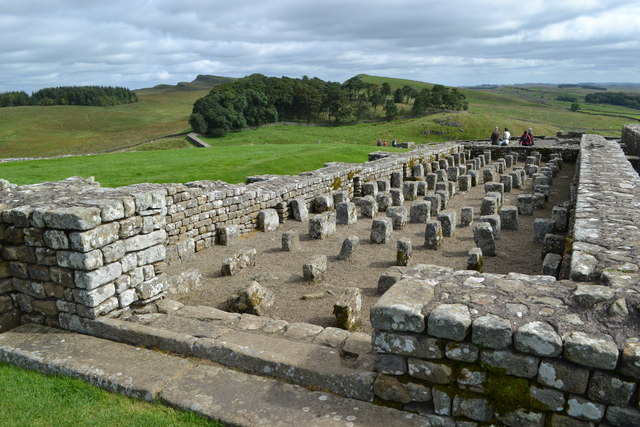
| Housesteads fort, section of Wall and vallum between the field boundary west of milecastle 36 and the field boundary west of turret 37a in wall miles 36 and 37 | 1018585 | n/a | Roman | Scheduled Monument |
| Hadrian's Wall and associated features between the boundary east of turret 34a and the field boundary west of milecastle 36 in wall miles 34, 35 and 36 | 1010964 | n/a | Roman | Scheduled Monument |
Primary source: the National Heritage List for England - NHLE is the register of nationally protected historic buildings and sites in England, including listed buildings, scheduled monuments, protected wrecks, registered parks and gardens, and battlefields. The list is maintained by Historic England. Check NHLE for updates and new entries. Secondary sources: British Listed Buildings and Keys to the Past.
Co-Curate Page
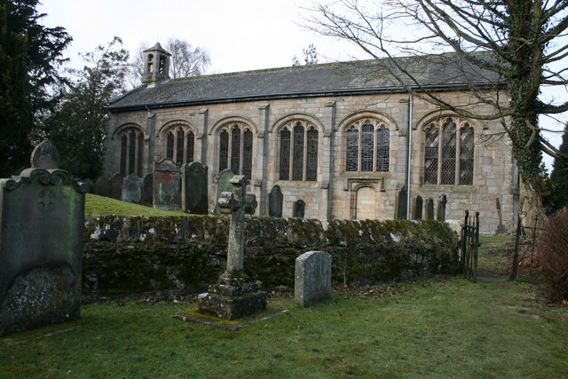
Church of St. Cuthbert, Beltingham
- Overview About the Church Map The Parish Church at Beltingham was built in the late 15th century, but with some older parts dating to c.1260. It was formerly a domestic …
Co-Curate Page
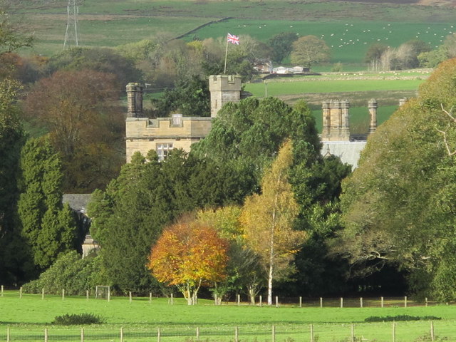
Ridley Hall
- Overview About Ridley Hall Map Ridley Hall is an 18th-century country house, now a residential and conference centre, at Bardon Mill, Northumberland. It is a Grade II listed building …

Co-Curate Page
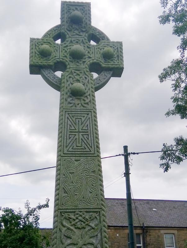
War Memorial, Bardon Mill
- Overview Map Street View The war memorial at Bardon Mill is a tall Celtic style wheel cross, on a square three stepped plinth, located on the Village Green. The memorial …
Co-Curate Page
Beltingham House
- Overview Map Street View Beltingham House, located at the north side of Beltingham and next to St Cuthbert's Church, dates from the mid-18th century. The building is Grade II listed …

Co-Curate Page
The Old Vicarage, Beltingham
- Overview Map Street View The Old Vicarage in Beltingham dates from 1845. The lintel above the basement door on right of the main block has an inscription: 'This House was built …
Co-Curate Page
White Heather Cottage, Beltingham
- Overview Map Street View White Heather Cottage, no.2 Beltingham Village, is a former Bastle House, dating from the late 16th or early 17th century. It was remodelled in the 18th …

Co-Curate Page
Wall Mile 37
- <Mile 36 | Mile 37 | Mile 38> Hadrian's Wall - Wall Mile 37 Hadrian's Wall stretches from the east to west coast of England and was an important frontier …

Co-Curate Page
Milecastle 37, Hadrian's Wall
- Overview Map Street View Hadrian's Wall Glossary Milecastle 37 is location on Wall Mile 37 of Hadrian's Wall, west of Housesteads (fort). The milecastle is situated in a cleft of …
Co-Curate Page
Housesteads
- Overview About Howsteads Fort Map Street View Interactive Glossary Housesteads (Roman name: "Vercovicium") is one of the best preserved forts on Hadrian's Wall, built around 124 AD. The fort covers …

Co-Curate Page
Wall Mile 36
- Overview Map Street View Hadrian's Wall Glossary <Mile 35 | Mile 36 | Mile 37> Hadrian's Wall - Wall Mile 36 Hadrian's Wall stretches from the east to west coast …

Co-Curate Page
Partridge Nest (farm), Bardon Mill
- Overview Map Street View Partridge Nest farm and cottage are located near the south bank of the River South Tyne, about half mile WNW of Beltingham. The farmhouse here dates …

Co-Curate Page
The Knowe, Bardon Mill
- Overview Map Street View The Knowe (aka Grandy's Knowe) is a former farm in Northumberland, located on Hallstile Bank, about 3 miles north of Bardon Mill, to the south of …
Co-Curate Page
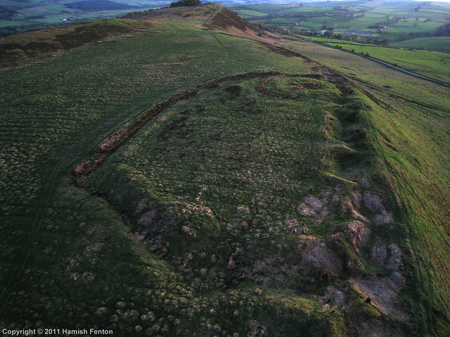
Hillfort and Roman signal station, Barcombe Hill
- Overview Map Scheduled Monument area - based on Historic England data (Open Government Licence). The remains of an Iron Age defended settlement and Roman signal station are located on Barcombe …

Co-Curate Page
Wall Mile 38
- <Mile 37 | Mile 38 | Mile 39> Hadrian's Wall - Wall Mile 38 Hadrian's Wall stretches from the east to west coast of England and was an important frontier …

Co-Curate Page
Church of St. Cuthbert, Beltingham
- Overview About the Church Map The Parish Church at Beltingham was built in the late 15th century, but with some older parts dating to c.1260. It was formerly a domestic …
Co-Curate Page
Ridley Hall
- Overview About Ridley Hall Map Ridley Hall is an 18th-century country house, now a residential and conference centre, at Bardon Mill, Northumberland. It is a Grade II listed building …
Co-Curate Page
War Memorial, Bardon Mill
- Overview Map Street View The war memorial at Bardon Mill is a tall Celtic style wheel cross, on a square three stepped plinth, located on the Village Green. The memorial …
Co-Curate Page
Beltingham House
- Overview Map Street View Beltingham House, located at the north side of Beltingham and next to St Cuthbert's Church, dates from the mid-18th century. The building is Grade II listed …
Co-Curate Page
The Old Vicarage, Beltingham
- Overview Map Street View The Old Vicarage in Beltingham dates from 1845. The lintel above the basement door on right of the main block has an inscription: 'This House was built …
Co-Curate Page
White Heather Cottage, Beltingham
- Overview Map Street View White Heather Cottage, no.2 Beltingham Village, is a former Bastle House, dating from the late 16th or early 17th century. It was remodelled in the 18th …
Co-Curate Page
Wall Mile 37
- <Mile 36 | Mile 37 | Mile 38> Hadrian's Wall - Wall Mile 37 Hadrian's Wall stretches from the east to west coast of England and was an important frontier …
Co-Curate Page
Milecastle 37, Hadrian's Wall
- Overview Map Street View Hadrian's Wall Glossary Milecastle 37 is location on Wall Mile 37 of Hadrian's Wall, west of Housesteads (fort). The milecastle is situated in a cleft of …
Co-Curate Page
Housesteads
- Overview About Howsteads Fort Map Street View Interactive Glossary Housesteads (Roman name: "Vercovicium") is one of the best preserved forts on Hadrian's Wall, built around 124 AD. The fort covers …
Co-Curate Page
Wall Mile 36
- Overview Map Street View Hadrian's Wall Glossary <Mile 35 | Mile 36 | Mile 37> Hadrian's Wall - Wall Mile 36 Hadrian's Wall stretches from the east to west coast …
Co-Curate Page
Partridge Nest (farm), Bardon Mill
- Overview Map Street View Partridge Nest farm and cottage are located near the south bank of the River South Tyne, about half mile WNW of Beltingham. The farmhouse here dates …
Co-Curate Page
The Knowe, Bardon Mill
- Overview Map Street View The Knowe (aka Grandy's Knowe) is a former farm in Northumberland, located on Hallstile Bank, about 3 miles north of Bardon Mill, to the south of …
Co-Curate Page
Hillfort and Roman signal station, Barcombe Hill
- Overview Map Scheduled Monument area - based on Historic England data (Open Government Licence). The remains of an Iron Age defended settlement and Roman signal station are located on Barcombe …


