Topics > Northumberland > Civil Parishes in Northumberland > Haydon Civil Parish > Langley Barony Lead Mine
Langley Barony Lead Mine
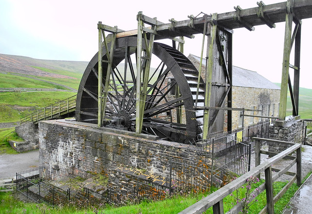
The remains of Langley Barony Mines are located about 2½ miles north-west of Haydon Bridge. The mine, with several adict shafts, covered a wide geographical area and is a Scheduled Monument. These were 19th-century (initially) lead and (later) coal mines, famous for their impressive engine houses, chimney, and pumping engines, operating alongside the Langley Barony of the historic Langley Castle estate, with remnants like the engine house still visible, representing an important era of local industrial heritage before the mines closed around 1926.

from Geograph (geograph)
Langley Barony Lead Mine - channel of Honeycrook Burn (2)
Pinned by Simon Cotterill

from Geograph (geograph)
Langley Barony Lead Mine - channel of Honeycrook Burn (4)
Pinned by Simon Cotterill

from Geograph (geograph)
Langley Barony Lead Mine - channel of Honeycrook Burn
Pinned by Simon Cotterill


from Geograph (geograph)
Langley Barony Lead Mine - entrance of the Honeycrook Adit (2)
Pinned by Simon Cotterill

from Geograph (geograph)
Langley Barony Lead Mine - western end of water overflow tunnel
Pinned by Simon Cotterill


from Geograph (geograph)
Langley Barony Lead Mine - engine house and diverted burn
Pinned by Simon Cotterill

from Geograph (geograph)
Langley Barony Lead Mine - engine and boiler house
Pinned by Simon Cotterill


from Geograph (geograph)
Langley Barony Lead Mine - engine and boiler house (4)
Pinned by Simon Cotterill


from Geograph (geograph)
Langley Barony Lead Mine - chimney of the engine and boiler house (2)
Pinned by Simon Cotterill


from Geograph (geograph)
Langley Barony Lead Mine - crushing mill, buddle pit and spoil heap
Pinned by Simon Cotterill


from Geograph (geograph)
Langley Barony Lead Mine - mineral rights boundary marker
Pinned by Simon Cotterill

from Geograph (geograph)
Langley Barony Lead Mine - mineral rights boundary marker (2)
Pinned by Simon Cotterill


from Geograph (geograph)
Langley Barony Lead Mine - wall diverting Honeycrook Burn
Pinned by Simon Cotterill


from Geograph (geograph)
Langley Barony Lead Mine - channel of Honeycrook Burn (2)
Pinned by Simon Cotterill
from Geograph (geograph)
Langley Barony Lead Mine - channel of Honeycrook Burn (4)
Pinned by Simon Cotterill
from Geograph (geograph)
Langley Barony Lead Mine - channel of Honeycrook Burn
Pinned by Simon Cotterill
from Geograph (geograph)
Langley Barony Lead Mine - entrance of the Honeycrook Adit (2)
Pinned by Simon Cotterill
from Geograph (geograph)
Langley Barony Lead Mine - western end of water overflow tunnel
Pinned by Simon Cotterill
from Geograph (geograph)
Langley Barony Lead Mine - engine house and diverted burn
Pinned by Simon Cotterill
from Geograph (geograph)
Langley Barony Lead Mine - engine and boiler house
Pinned by Simon Cotterill
from Geograph (geograph)
Langley Barony Lead Mine - engine and boiler house (4)
Pinned by Simon Cotterill
from Geograph (geograph)
Langley Barony Lead Mine - chimney of the engine and boiler house (2)
Pinned by Simon Cotterill
from Geograph (geograph)
Langley Barony Lead Mine - crushing mill, buddle pit and spoil heap
Pinned by Simon Cotterill
from Geograph (geograph)
Langley Barony Lead Mine - mineral rights boundary marker
Pinned by Simon Cotterill
from Geograph (geograph)
Langley Barony Lead Mine - mineral rights boundary marker (2)
Pinned by Simon Cotterill
from Geograph (geograph)
Langley Barony Lead Mine - wall diverting Honeycrook Burn
Pinned by Simon Cotterill