Topics > County Durham > Civil Parishes in County Durham > Lanchester Civil Parish > Historic Buildings and Monuments in Lanchester Civil Parish
Historic Buildings and Monuments in Lanchester Civil Parish
Listed buildings and scheduled monuments in Lanchester Civil Parish, County Durham, from the National Heritage List for England[1]. Use the Search (below) if looking for a specific building / monument. Additional buildings may also be included, including from the Lanchester Community Heritage Audit, published by Lanchester Parish Council in 2017.
| Structure | List No. | Grade | Built~ | Notes |
|---|---|---|---|---|
| No. 39, Front Street | 1185988 | II | ||
| Biggin Farm Cottage | 1185993 | II | ||
| Boundary Stone at West Side of Former Railway Line | 1233311 | II | ||
| Boundary Stone Circa 220 Metres West of Stuartfield Lodge | 1299410 | II | ||
| Brookvilla | 1185986 | II | C19th | Front Street |
| Burnhopeside Hall | 1299442 | II* | ||
| Burnhopeside Hall Farmhouse and Farm Buildings | 1116101 | II* | ||
| Church of All Saints | 1185983 | I | C12th | |
| Colepike Hall and Attached Wall | 1116083 | II | C19th | Near the B6296 |
| Deanery Farmhouse and Cottage with Attached Barn | 1185982 | II | ||
| East Barn at Broadwood Home Farm | 1320292 | II | ||
| Fenhall Lodge | 1116332 | II | ||
| Garden Wall North East of Woodlands Hall | 1299409 | II | ||
| Hamsteels Hall Farmhouse | 1115409 | II* | ||
| Hollinside Terrace | 1320276 | II | 1892 | Hollinside |
| Humber House Farmhouse | 1185991 | II | ||
| Hurbuck Farmhouse | 1299408 | II | ||
| Icehouse Circa 100 Metres North East of Burnhopeside Hall | 1185977 | II | ||
| Lanchester House with Walls in Front | 1320434 | II | ||
| Lanchester Post Office | 1185987 | II | ||
| Lodge Well Circa 100 Metres to South of the Lodge | 1115582 | II | ||
| Milestone Circa 50 Metres North of Junction with Eliza Lane | 1185976 | II | ||
| Milestone Opposite South End of Hollinside Terrace | 1299403 | II | C18th | Hollinside |
| Milestone South West of Broadwood Cottages | 1299404 | II | ||
| New Field House | 1115502 | II | ||
| Patrick Tomb Circa 13 Metres East of Church of All Saints | 1185984 | II | ||
| Piers and Walls South East of Fenhall Lodge | 1185966 | II | ||
| Prospect House | 1185985 | II | ||
| Pumping House Circa 100 Metres South of Broadwood Farm | 1299405 | II | ||
| Queens Head Public House | 1115479 | II | ||
| Smith Opposite Broadwood Cottages | 1185979 | II | ||
| Terrace Wall and Piers in Front of Colepike Hall | 1185978 | II | ||
| The Deanery | 1115559 | II | ||
| The Lodge | 1185981 | II | C19th | Durham Road |
| Walls and Piers in Front of Garden of Colepike Hall | 1116052 | II | ||
| Walls and Piers in Front of the Deanery | 1299406 | II | ||
| Walls Steps Piers Railings and Gates to South and East of Church of All Saints | 1320381 | II | ||
| War memorial outside All Saints' Roman Catholic Church, Lanchester | 1438929 | II | ||
| West Barn at Broadwood Home Farm | 1185980 | II | ||
| White Tomb Circa 40 Metres North East of Church of All Saints | 1115520 | II | ||
| Woodlands Hall | 1185992 | II | ||
| Lanchester Roman fort (Longovicium) | 1002361 | n/a | C2nd | Scheduled Monument |
| Remains of Roman aqueduct | 1005582 | n/a | Scheduled Monument | |
| All Saints Catholic Primary School | - | Not Listed | 1905 | Kitswell Road |
| Lanchester Methodist Church | - | Not Listed | 1868 | Front Street |
Primary source: the National Heritage List for England - NHLE is the register of nationally protected historic buildings and sites in England, including listed buildings, scheduled monuments, protected wrecks, registered parks and gardens, and battlefields. The list is maintained by Historic England. Check NHLE for updates and new entries. Secondary sources: British Listed Buildings, Keys to the Past, and Lanchester Community Heritage Audit.
Co-Curate Page
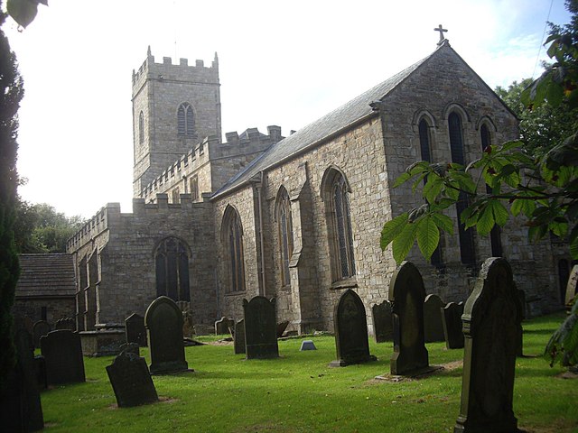
All Saints CofE Church
- Overview Map Street View All Saints is the Parish church in Lanchester, County Durham. The original building dates from the mid 12th Century, and was extended by the Bishop of …
Co-Curate Page
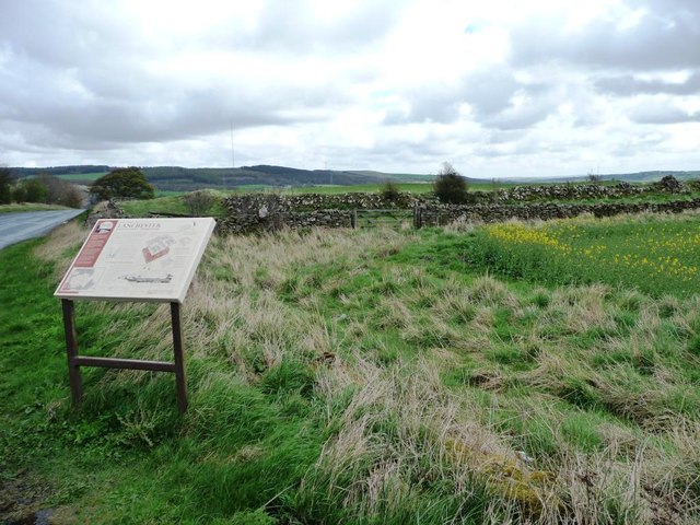
Longovicium, Lanchester Roman Fort
- Overview About Longovicium Map Street View Longovicium was a Roman fort established in the mid 2nd century AD, which lay on Dere Street, the Roman road connecting York with the …
from https://lanchesterparishcounc…
Gazetteer of Heritage Assets
- Appendix from the final report of the Lanchester Community Heritage Audit, 2017.
Added by
Simon Cotterill
from https://lanchesterparishcounc…
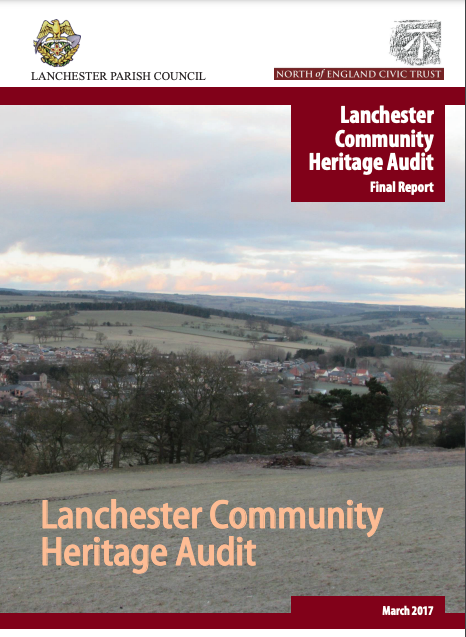
Lanchester Community Heritage Audit
- Final report, 2017. "The Lanchester Heritage Audit was carried out by a working group of volunteers from the localcommunity, with support from North of England Civic Trust (NECT).
...Through a …
Added by
Simon Cotterill
Co-Curate Page
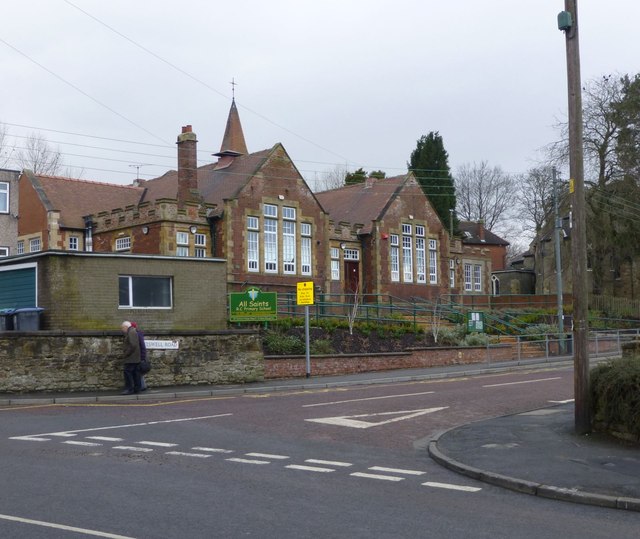
All Saints' Catholic Primary School
- Overview Map Street View All Saints' Catholic Primary School is located on Kitswell Road in Lanchester. The school has about 200 pupils aged 3 to 11. The school converted from …
Co-Curate Page
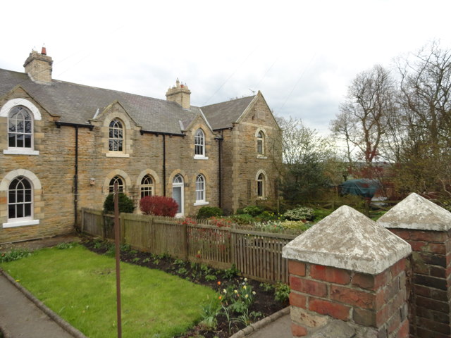
Hollinside Terrace
- Overview Map Street View Hollinside Terrace is located beside the B6296 road, at Hollinside, about a mile south-west of Lanchester in County Durham. The terrace is dated 1892, and was …
Co-Curate Page
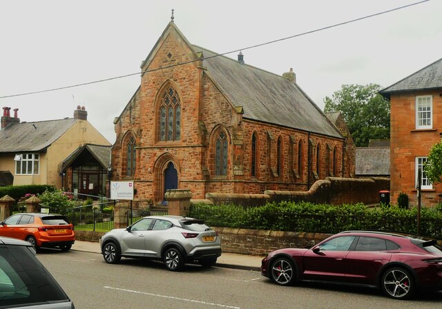
Lanchester Methodist Church
- The Methodist Church is located on Front Street in Lanchester. The church opened on 21st August 1868.

Co-Curate Page
All Saints CofE Church
- Overview Map Street View All Saints is the Parish church in Lanchester, County Durham. The original building dates from the mid 12th Century, and was extended by the Bishop of …
Co-Curate Page
Longovicium, Lanchester Roman Fort
- Overview About Longovicium Map Street View Longovicium was a Roman fort established in the mid 2nd century AD, which lay on Dere Street, the Roman road connecting York with the …
from https://lanchesterparishcounc…
Gazetteer of Heritage Assets
- Appendix from the final report of the Lanchester Community Heritage Audit, 2017.
Added by
Simon Cotterill
from https://lanchesterparishcounc…
Lanchester Community Heritage Audit
- Final report, 2017. "The Lanchester Heritage Audit was carried out by a working group of volunteers from the localcommunity, with support from North of England Civic Trust (NECT).
...Through a …
Added by
Simon Cotterill
Co-Curate Page
All Saints' Catholic Primary School
- Overview Map Street View All Saints' Catholic Primary School is located on Kitswell Road in Lanchester. The school has about 200 pupils aged 3 to 11. The school converted from …
Co-Curate Page
Hollinside Terrace
- Overview Map Street View Hollinside Terrace is located beside the B6296 road, at Hollinside, about a mile south-west of Lanchester in County Durham. The terrace is dated 1892, and was …


