Topics > Northumberland > Civil Parishes in Northumberland > Knarsdale with Kirkhaugh Civil Parish > Historic Buildings and Monuments in Knaresdale with Kirkhaugh CP
Historic Buildings and Monuments in Knaresdale with Kirkhaugh CP
Listed buildings and scheduled monuments in the Civil Parish of Knaresdale with Kirkhaugh, Northumberland, from the National Heritage List for England[1]. In the absence of a published 'local list', some other public buildings of interest may also be included. Use the Search (below) if looking for a specific building / monument.
| Structure | List No. | Grade | Built~ | Notes |
|---|---|---|---|---|
| 4 Headstones 18 Metres South of South-East Corner of Parish Church Nave | 1370633 | II | 1740s | Knarsdale, St Jude's churchyard |
| Ayle Well and Adjacent Farmbuilding | 1303398 | II | c.1730 | Ayle |
| Blackcleugh Farmhouse and Adjacent Farmbuildings | 1303376 | II | C18th | |
| Bridge over the Knar Burn 200 Metres East of Knar Farmhouse | 1042926 | II | C18th | Knar |
| Burnstones Bridge Carrying A689 over Thinhope Burn | 1370630 | II | C18th | Burnstones |
| Burnstones Cottage and Adjacent Outbuilding to South | 1155419 | II | C18th | Burnstones |
| Burnstones Farmhouse | 1042923 | II | C18th | Burnstones. Renamed to Knarsdale Hall. |
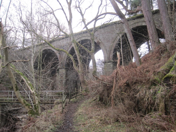
| Burnstones Railway Viaduct (Over the A689 and the Thinhope Burn) | 1370631 | II | 1852 | Burnstones |
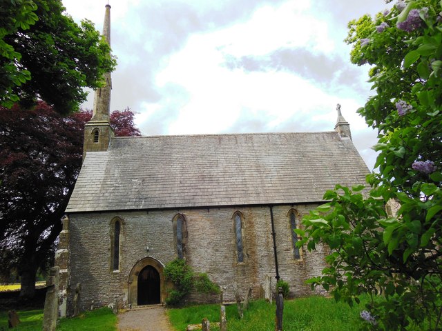
| Church of the Holy Paraclete | 1042925 | II | 1869 | Kirkhaugh. On medieval site. |
| Cross 10 Metres South of Parish Church Door | 1155479 | II* | Pre-Conquest | Knarsdale, St Jude's churchyard |
| Eals Bridge (Over the South Tyne) | 1155442 | II | 1733 | Eals |
| Eals Farmhouse | 1042924 | II | C18th | Eals |
| Farmbuilding 120 Metres West North West of Whitlow Farmhouse | 1370629 | II | C16th | |
| Gilderdale Bridge | 1104899 | II | 1836 | Road Bridge. Partly in this parish. |
| Gilderdale Viaduct | 1144983 | II | 1852 | Rail Bridge. Partly in this parish. |
| Greenhaugh Farmhouse and Adjacent Farmbuildings | 1155533 | II | C17th | Includes former bastle |
| High Luzley, Former Farmhouse | 1042927 | II | C18th | |
| Knarsdale Hall Farmhouse | 1155547 | II | C17th | The 'old hall' |
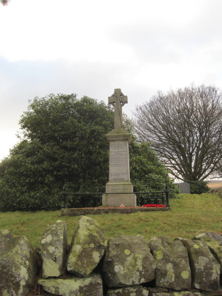
| Knarsdale War Memorial | 1438722 | II | c.1920 | Knarsdale, St Jude's churchyard |
| Low Row, the Southern of the Two Former Houses | 1042920 | II | C17th | |
| Outbuilding 20 Metres S0uth-West of Knarsdale Hall Farmhouse | 1042928 | II | C17th | |
| Railway Viaduct over Knar Burn | 1155595 | II | 1852 | Disused. Near Slaggyford |
| Railway Viaduct over the Gilderdale Burn 250m North-East of Gilderdale Bridge | 1155323 | II | 1852 | |
| Range of Farmbuildings 10 Metres North East of Underbank Farmhouse | 1303309 | II | C16th | |
| Range of Farmbuildings 30 Metres South of Kirkhaugh Farmhouse | 1370632 | II | C16th | |
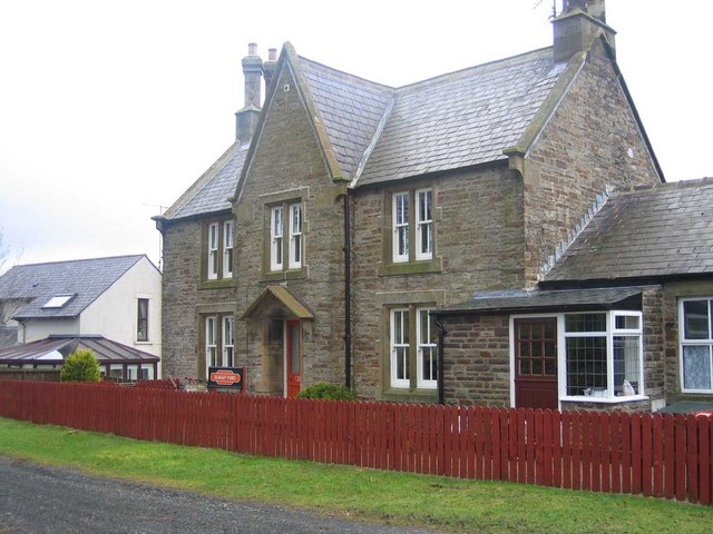
| Slaggyford Station | 1042929 | II | 1852 | Slaggyford |
| Stonecrop | 1155444 | II | 1760 | Eals. Cottage. |
| White Lea House and Adjacent Farmbuilding | 1042922 | II | C16th | |
| Kirkhaugh Bridge abutments 1/2 mile (800m) NE of Whitley Castle | 1006577 | n/a | Roman | Scheduled Monument |
| Whitley Castle Roman fort and vicus, 280m south west of Castle Nook | 1006621 | n/a | Roman | Scheduled Monument. Epiacum |
| Maiden Way Roman road over Hartleyburn Common and Glendue Fell | 1006439 | n/a | Roman | Scheduled Monument |
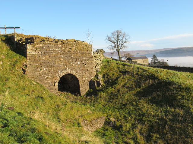
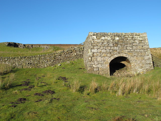
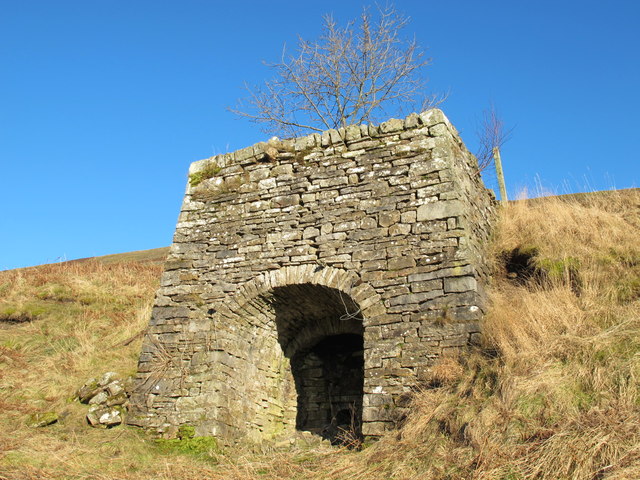
| Limekiln at Hanging Shaw | not listed | n/a | C19th | Hanging Shaw |
| Limekiln Below Limestone Hill | not listed | n/a | C19th | Limestone Hill |
| Barhauh Hall | not listed | n/a | C19th | |
| Former Wesleyan Chapel | not listed | n/a | 1871 | Eals |
| Kirkstyle Inn & Sportsmans Rest | not listed | n/a | C19th | Knarsdale |
| Williamston farmhouse | not listed | n/a | 1657 | Williamston |
| Limekiln at Parson Shields | not listed | n/a | C19th | Parson Shields |
Primary source: the National Heritage List for England - NHLE is the register of nationally protected historic buildings and sites in England, including listed buildings, scheduled monuments, protected wrecks, registered parks and gardens, and battlefields. The list is maintained by Historic England. Check NHLE for updates and new entries. Secondary sources: British Listed Buildings and Keys to the Past.
Co-Curate Page
Slaggyford Station
- Slaggyford Station was on the Alston to Haltwhistle branch of the Newcastle & Carlisle Railway, which opened on the 17th November 1852. The station at Slaggyford was the first stopping …
Co-Curate Page
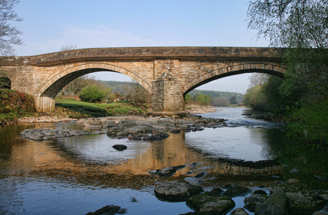
Gilderdale Bridge
- Overview Map Street View Gilderdale Bridge carries the A689 road over Gilderdale Burn, about 1 mile south-east of Kirkhaugh and 1½ miles north-west of Alston. The stone bridge was built in 1836 …

Co-Curate Page
Bridge over Knar Burn
- Overview Map There is a hump-backed bridge over Knar Burn, located 200 metres north-east of Knar Farmhouse. The stone segmental arch bridge dates from the 18th century. It is Grade …
Co-Curate Page
Burnstones Bridge
- Overview Map Street View Burnstones Bridge carries the A689 road over Thinhope Burn. The bridge, at Burnstones, dates from the 18th century; it was rebuilt in 1940 from original materials …
Co-Curate Page
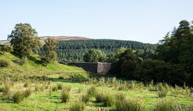
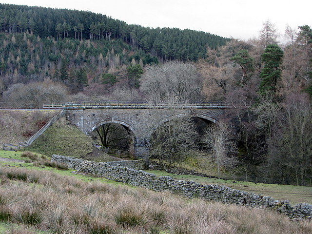
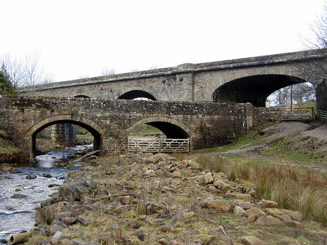
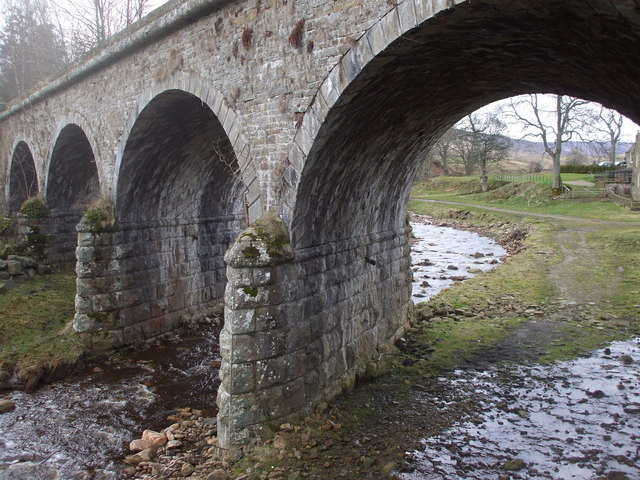
Burnstones Railway Viaduct
- Overview Map Street View Burnstones Viaduct was built by Sir George Barclay Bruce in 1852 to carry the Haltwhistle and Alston Moor branch of the Newcastle and Carlisle Railway Company, …
Co-Curate Page
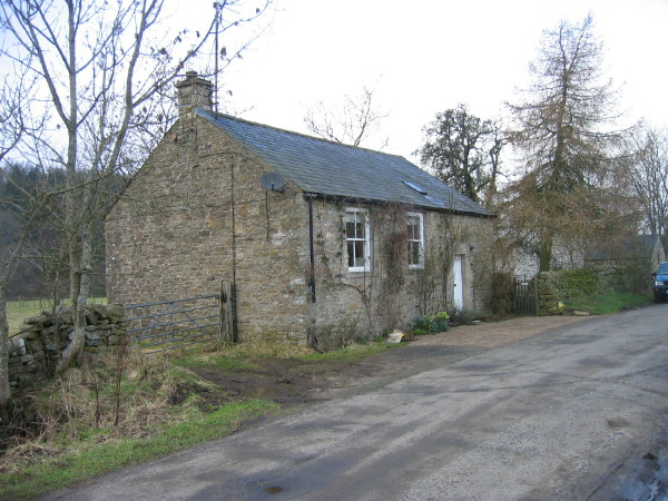
Former Wesleyan Chapel, Eals
- This house in the hamlet of Eals was originally built a Wesleyan Chapel in 1871. After the chapel closed it was converted into a house.
Co-Curate Page
Eals Bridge over the River South Tyne
- Overview Map Street View Eals Bridge carries the road over the River South Tyne south of Eals in Northumberland. The stone bridge dates from 1733 has two segmental arches. It …
Co-Curate Page
Stonecrop (cottage), Eals
- Stonecrop is a cottage in Eals, Northumberland. It is dated 1760, with the initials IPM (Isaac Matthew Parker) on the lintel. The cottage is Grade II listed on the National …
Co-Curate Page
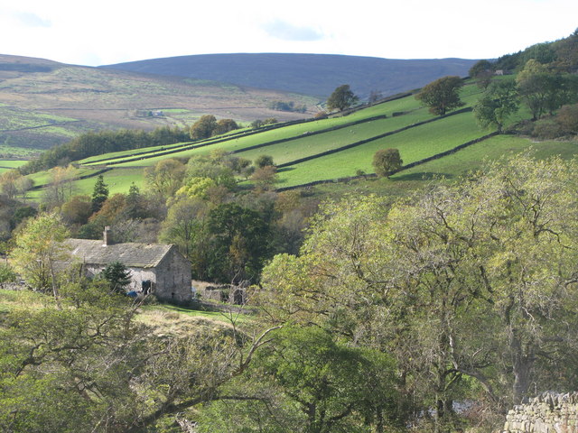
Blackcleugh (Knarsdale)
- Overview Map Blackcleugh is a farm in Northumberland, located about 1½ mile north-east of the village of Slaggyford and 3½ miles north of Alston. Blackcleugh is situated near the confluence …
Co-Curate Page
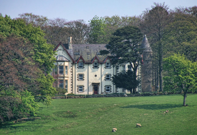
Barhauh Hall
- Overview Map Street View Barhauh Hall is located by about 3½ miles north of Alston and is situated by the confluence of Barhaugh Burn with the River South Tyne. Barhauh …
Co-Curate Page
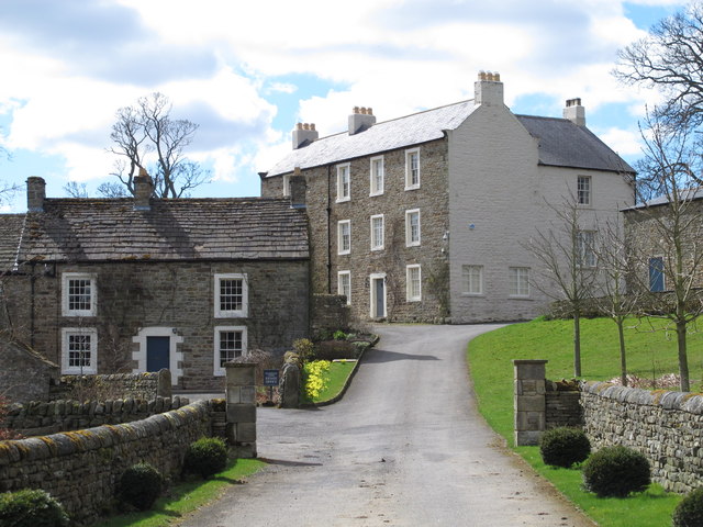
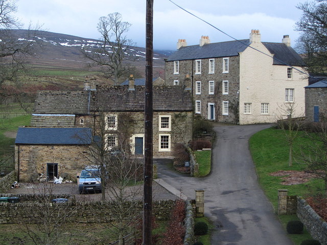
Knarsdale Hall, Burnstones
- Overview Map Street View Knarsdale Hall in Burnstones is a former Inn, now house. It dates from the 18th century, and was extended and then heightened in early 19th century. …
Co-Curate Page
Burnstones Cottage
- Overview Map Street View The cottage to the east of Knarsdale Hall in Burnstones dates from the 18th century. Burnstones Cottage and it's adjacent outbuilding are Grade II listed on …
Co-Curate Page
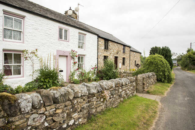
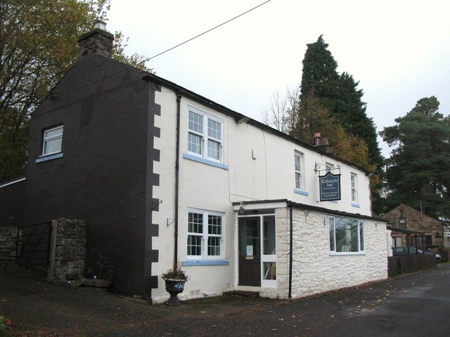
The Kirkstyle Inn and Sportsman’s Rest, Knarsdale
- Overview Map Street View The Kirkstyle Inn and Sportsman’s Rest is located in Knarsdale, a short distance off the A689. "It is believed that it was originally the rectory, and …

Co-Curate Page
Williamston, Northumberland
- Overview Map Street View Williamston is a 1,000-acre hill farm in Northumberland, situated by the north banks of the River South Tyne, about ½ mile south-east of the village of …

Co-Curate Page
Whitley Castle Roman Fort (Epiacum)
- Overview Street View Map of Whitley Castle Roman fort (Epiacum) - Scheduled Monument Area The remains of Epiacum Roman Fort are located about 1½ miles north-west of Alston. The fort …
Co-Curate Page
Kirkhaugh Roman Bridge Abutments
- Scheduled Monument (#1006577): Kirkhaugh Bridge abutments 1/2 mile (800m) NE of Whitley Castle Click the headings below to expand (selected extracts from the Historic England scheduling) Significance Roman bridges are …

Co-Curate Page
Slaggyford Station
- Slaggyford Station was on the Alston to Haltwhistle branch of the Newcastle & Carlisle Railway, which opened on the 17th November 1852. The station at Slaggyford was the first stopping …
Co-Curate Page
Gilderdale Bridge
- Overview Map Street View Gilderdale Bridge carries the A689 road over Gilderdale Burn, about 1 mile south-east of Kirkhaugh and 1½ miles north-west of Alston. The stone bridge was built in 1836 …
Co-Curate Page
Bridge over Knar Burn
- Overview Map There is a hump-backed bridge over Knar Burn, located 200 metres north-east of Knar Farmhouse. The stone segmental arch bridge dates from the 18th century. It is Grade …
Co-Curate Page
Burnstones Bridge
- Overview Map Street View Burnstones Bridge carries the A689 road over Thinhope Burn. The bridge, at Burnstones, dates from the 18th century; it was rebuilt in 1940 from original materials …
Co-Curate Page
Burnstones Railway Viaduct
- Overview Map Street View Burnstones Viaduct was built by Sir George Barclay Bruce in 1852 to carry the Haltwhistle and Alston Moor branch of the Newcastle and Carlisle Railway Company, …
Co-Curate Page
Former Wesleyan Chapel, Eals
- This house in the hamlet of Eals was originally built a Wesleyan Chapel in 1871. After the chapel closed it was converted into a house.
Co-Curate Page
Eals Bridge over the River South Tyne
- Overview Map Street View Eals Bridge carries the road over the River South Tyne south of Eals in Northumberland. The stone bridge dates from 1733 has two segmental arches. It …
Co-Curate Page
Stonecrop (cottage), Eals
- Stonecrop is a cottage in Eals, Northumberland. It is dated 1760, with the initials IPM (Isaac Matthew Parker) on the lintel. The cottage is Grade II listed on the National …
Co-Curate Page
Blackcleugh (Knarsdale)
- Overview Map Blackcleugh is a farm in Northumberland, located about 1½ mile north-east of the village of Slaggyford and 3½ miles north of Alston. Blackcleugh is situated near the confluence …
Co-Curate Page
Barhauh Hall
- Overview Map Street View Barhauh Hall is located by about 3½ miles north of Alston and is situated by the confluence of Barhaugh Burn with the River South Tyne. Barhauh …
Co-Curate Page
Knarsdale Hall, Burnstones
- Overview Map Street View Knarsdale Hall in Burnstones is a former Inn, now house. It dates from the 18th century, and was extended and then heightened in early 19th century. …
Co-Curate Page
Burnstones Cottage
- Overview Map Street View The cottage to the east of Knarsdale Hall in Burnstones dates from the 18th century. Burnstones Cottage and it's adjacent outbuilding are Grade II listed on …
Co-Curate Page
The Kirkstyle Inn and Sportsman’s Rest, Knarsdale
- Overview Map Street View The Kirkstyle Inn and Sportsman’s Rest is located in Knarsdale, a short distance off the A689. "It is believed that it was originally the rectory, and …
Co-Curate Page
Williamston, Northumberland
- Overview Map Street View Williamston is a 1,000-acre hill farm in Northumberland, situated by the north banks of the River South Tyne, about ½ mile south-east of the village of …
Co-Curate Page
Whitley Castle Roman Fort (Epiacum)
- Overview Street View Map of Whitley Castle Roman fort (Epiacum) - Scheduled Monument Area The remains of Epiacum Roman Fort are located about 1½ miles north-west of Alston. The fort …
