Topics > Northumberland > Civil Parishes in Northumberland > Kielder Civil Parish > Historic Buildings and Monuments in Kielder Civil Parish
Historic Buildings and Monuments in Kielder Civil Parish
Listed buildings and scheduled monuments in Kielder Civil Parish, Northumberland, from the National Heritage List for England[1]. Use the Search (below) if looking for a specific building / monument.
| Structure | List No. | Grade | Built~ | Notes |
|---|---|---|---|---|
| Bloodybush Pillar | 1044859 | II* | 1828 | Toll pillar. |
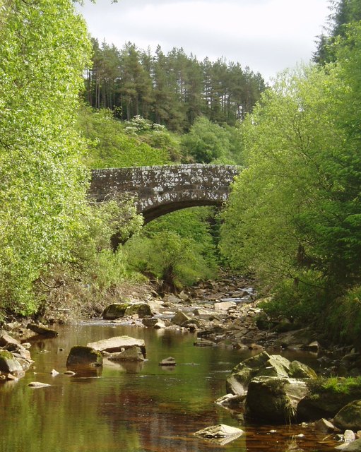
| Bridge over Lewis Burn | 1044860 | II | 1829 | The Forks. |
| Gatepiers C.40 Yards North of Kielder Castle | 1370512 | II | c.1775 | |
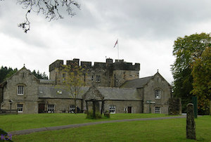
| Kielder Castle | 1302999 | II | 1775 | |
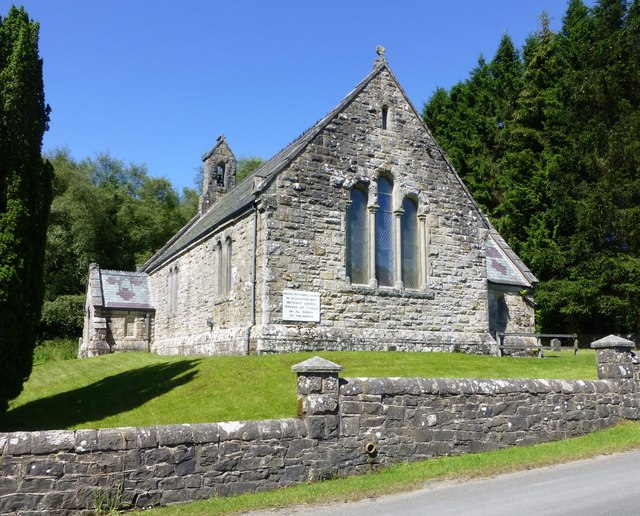
| United Reformed Church | 1156185 | II | 1874 | |
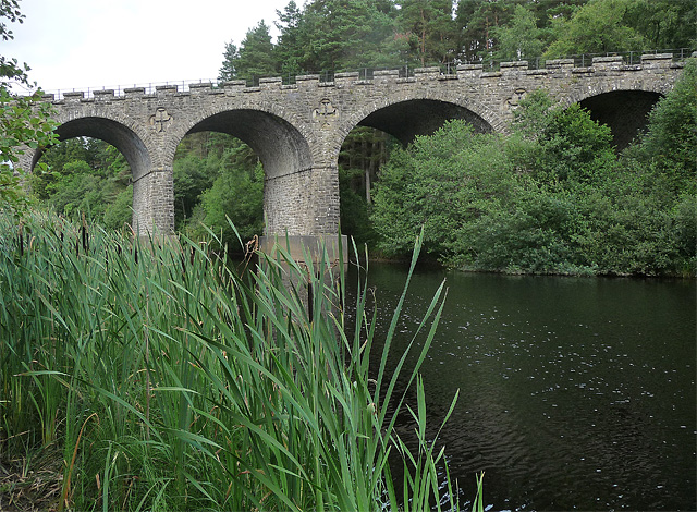
| Kielder Viaduct | 1002913 | n/a | 1862 | Scheduled Monument. Former railway viaduct. |
| Bran's Walls Romano-British enclosed settlements, 400m SSE of Kielder Head | 1009670 | n/a | Scheduled Monument | |
| Round cairn, 330m SSW of Deadman's Cairn | 1009671 | n/a | Scheduled Monument | |
| Romano-British enclosed settlement, 290m south east of Butteryhaugh Bridge | 1009667 | n/a | Scheduled Monument | |
| Gibbie's Knowe defended settlement and later rectangular building | 1014079 | n/a | Scheduled Monument | |
| Romano-British enclosed settlement, 720m north east of Catcleugh | 1009669 | n/a | Scheduled Monument | |
| Defended settlement 580m north west of Gowanburn and associated medieval buildings | 1009672 | n/a | Scheduled Monument | |
| Two round cairns 870m south east of Butteryhaugh Bridge including Deadman Cairn | 1009665 | n/a | Scheduled Monument | |
| Devil's Lapful Long Cairn, 1km east of Butteryhaugh Bridge | 1009666 | n/a | Scheduled Monument | |
| Midfell round cairn | 1009668 | n/a | Scheduled Monument | |
| Shieling on north bank of Lewis Burn | 1010042 | n/a | Scheduled Monument | |
| Kershope Castle | 1018956 | n/a | Scheduled Monument |
Primary source: the National Heritage List for England - NHLE is the register of nationally protected historic buildings and sites in England, including listed buildings, scheduled monuments, protected wrecks, registered parks and gardens, and battlefields. The list is maintained by Historic England. Check NHLE for updates and new entries.
Secondary sources: British Listed Buildings and Keys to the Past.
Co-Curate Page
Kielder Viaduct
- Overview Map Street View Kielder Viaduct spans the River North Tyne just north of Bakethin Reservoir and Kielder Water. It once carried the Border Counties Railway. The viaduct was completed in …
Co-Curate Page
United Reformed Church, Kielder
- The United Reformed Church in Kielder, Northumberland, was built in 1874, originally as a Presbyterian Church. The Romanesque style stone church was designed by F.R. Wilson.[1] The church is Grade …
Co-Curate Page
Bridge over Lewis Burn, The Forks
- Overview Map The bridge carrying Bloody Bush Road over Lewis Burn, is located near The Forks in Kielder Forest. It was built in 1829 for Sir J. Swinburn. The single …

Co-Curate Page
Kielder Viaduct
- Overview Map Street View Kielder Viaduct spans the River North Tyne just north of Bakethin Reservoir and Kielder Water. It once carried the Border Counties Railway. The viaduct was completed in …
Co-Curate Page
United Reformed Church, Kielder
- The United Reformed Church in Kielder, Northumberland, was built in 1874, originally as a Presbyterian Church. The Romanesque style stone church was designed by F.R. Wilson.[1] The church is Grade …


