Topics > Northumberland > Hexham > Historic Buildings and Monuments in Hexham
Historic Buildings and Monuments in Hexham
Listed buildings and scheduled monuments in Hexham, Northumberland, from the National Heritage List for England[1]. Use the Search (below) if looking for a specific building / monument.
| Structure | List No. | Grade | Built~ | Notes |
|---|---|---|---|---|
| Nos. 1 and 1a, Glover's Place | 1042592 | II | ||
| No. 1, Fore Street | 1042534 | II | ||
| No. 1, Hencotes | 1370794 | II | ||
| No. 10, Cockshaw | 1042615 | II | ||
| No. 10, Gilesgate | 1203731 | II | ||
| No. 10, Holy Island | 1203997 | II | ||
| No. 11, Battlehill | 1370773 | II | ||
| No. 11, Market Street | 1042544 | II | ||
| No. 12, Hencotes | 1042561 | II | ||
| Nos. 12-14, Holy Island | 1042574 | II | ||
| Nos. 13 and 15, Market Street | 1042545 | II | ||
| No. 14, Fore Street | 1370805 | II | ||
| No. 14, Hall Stile Bank | 1042597 | II | ||
| No. 14, Hencotes | 1370793 | II | ||
| No. 14, Market Place | 1370819 | II | ||
| No. 15, Hencotes | 1281463 | II | ||
| No. 15, Market Place | 1042535 | II | ||
| No. 15, St Mary's Chare | 1204147 | II | ||
| Nos. 16 and 18, Hencotes | 1042562 | II | ||
| No. 16, St Mary's Chare | 1370849 | II | ||
| Nos. 16-20, Fore Street | 1042584 | II | ||
| Nos. 17 and 18, Hallgate | 1203810 | II | ||
| No. 17, Hall Stile Bank | 1042596 | II | ||
| No. 17, Hencotes | 1370795 | II | ||
| Nos. 18 and 18a, Eastgate | 1042578 | II | ||
| No. 18, Market Street | 1042541 | II | ||
| No. 18, St Mary's Chare | 1204203 | II | ||
| Nos. 19 and 19a, St Marys Chare | 1370828 | II* | ||
| Nos. 19 and 20, Eastgate | 1370802 | II | ||
| Nos. 19 and 21, Battlehill | 1042602 | II | ||
| Nos. 19 and 21, Priestpopple | 1042547 | II* | ||
| No. 19, Hallgate | 1042594 | II | ||
| Nos. 2 and 4, St Mary's Chare | 1042555 | II | ||
| No. 2, Battlehill | 1370774 | II | ||
| No. 2, Gilesgate | 1203730 | II | ||
| Nos. 20 and 21, Market Place | 1370820 | II | ||
| Nos. 20 and 22, Market Street | 1370824 | II* | ||
| No. 20, Priestpopple | 1042550 | II | ||
| No. 20, St Mary's Chare | 1042513 | II | ||
| Nos. 22 and 24, Fore Street | 1370806 | II | ||
| No. 22, Market Place | 1042536 | II* | ||
| Nos. 23 and 25, Fore Street | 1042586 | II | ||
| Nos. 23 and 25, Hencotes | 1281468 | II | ||
| No. 23, Market Place | 1042537 | II | ||
| No. 23, Priestpopple | 1204132 | II | ||
| Nos. 24 and 26, Hall Stile Bank | 1042598 | II | ||
| No. 24, Market Street | 1281390 | II* | ||
| Nos. 25 and 26, Market Place | 1370821 | II | ||
| No. 26 and 28, Fore Street | 1281530 | II | ||
| No. 26, Market Street | 1042542 | II | ||
| Nos. 26-29, Hallgate | 1370809 | II | ||
| Nos. 27 and 28, Market Place | 1042538 | II* | ||
| Nos. 27 and 29, Fore Street | 1203729 | II | ||
| Nos. 29 and 30, Market Place | 1370822 | II | ||
| Nos. 3 and 5, Hencotes | 1042564 | II | ||
| No. 3 Gate Piers of East Lodge | 1203678 | II | ||
| No. 3, Market Street | 1370825 | II | ||
| No. 3, St Mary's Chare | 1204145 | II | ||
| No. 30, Fore Street | 1042585 | II | ||
| No. 30, Hall Stile Bank | 1370771 | II | ||
| No. 31 Market Place | 1042539 | II | ||
| Nos. 32 and 33, Market Place | 1370823 | II | ||
| No. 32, Hall Stile Bank | 1042556 | II | ||
| No. 35, Hencotes | 1042565 | II | ||
| No. 36, Fore Street | 1370807 | II | ||
| Nos. 36-40 Priestpopple | 1042551 | II | ||
| No. 37, Hencotes | 1370796 | II | ||
| Nos. 39 and 39a, Hencotes | 1281470 | II | ||
| No. 4, Battlehill | 1042603 | II | ||
| No. 4, Cattle Market | 1370778 | II | ||
| No. 4, Market Street | 1042540 | II | ||
| No. 4, Meal Market | 1042546 | II | ||
| Nos. 4-8, Gilesgate | 1042591 | II | ||
| No. 43, Hencotes | 1042566 | II | ||
| No. 45, Gilesgate | 1042587 | II | ||
| Nos. 47 and 49, Gilesgate | 1042588 | II | ||
| Nos. 5 and 7, St Mary's Chare | 1042553 | II | ||
| Nos. 6 and 8, Battlehill | 1370775 | II | ||
| Nos. 6 and 8, Hencotes | 1370792 | II | ||
| Nos. 6 and 8, Market Street | 1204104 | II | ||
| No. 6, St Mary's Chare | 1204190 | II | ||
| No. 7, Market Street | 1042543 | II | ||
| Nos. 8 and 9, Cockshaw | 1042614 | II | ||
| Nos. 8 and 9, Holy Island | 1370798 | II | ||
| No. 8, St Mary's Chare | 1370829 | II | ||
| No. 9, Beaumont Street | 1281575 | II | ||
| No. 9, Market Street | 1204123 | II | ||
| Nos. 9-13, St Mary's Chare | 1370827 | II | ||
| Abutments and Retaining Walls to Road Bridge over Line to West and South of Hexham Railway Station | 1064785 | II | ||
| Archway to Church Flags | 1042613 | II | ||
| Archway to East of Number 25, Adjacent to Number 26 | 1042595 | II | ||
| Archway to Garden of Manor Cottage and Wall Before Manor Office | 1370808 | II | ||
| Archway to North West of the Old Grammar School | 1042640 | II | ||
| Archway to West of Number 1 Orchard Place | 1042552 | II | ||
| Bagraw Farmhouse | 1281417 | II | ||
| Bandstand | 1370810 | II | ||
| Barclays Bank | 1042549 | II | ||
| Barn to West of Highside Farmhouse | 1370750 | II | ||
| Barn with Horse Engine North West of Highwood Farmhouse | 1042519 | II | ||
| Bellevue | 1203673 | II | ||
| Benson of Allerwash Memorial Gates | 1042606 | II | ||
| Breckon Hill Farmhouse | 1042635 | II | ||
| Bridge and Causeway over Halgut Burn | 1042617 | II | ||
| Bridge on Path South of Cuddy's Lane, Also over Halgut Burn | 1203691 | II | ||
| Bridge over Cockshaw Burn | 1370812 | II | ||
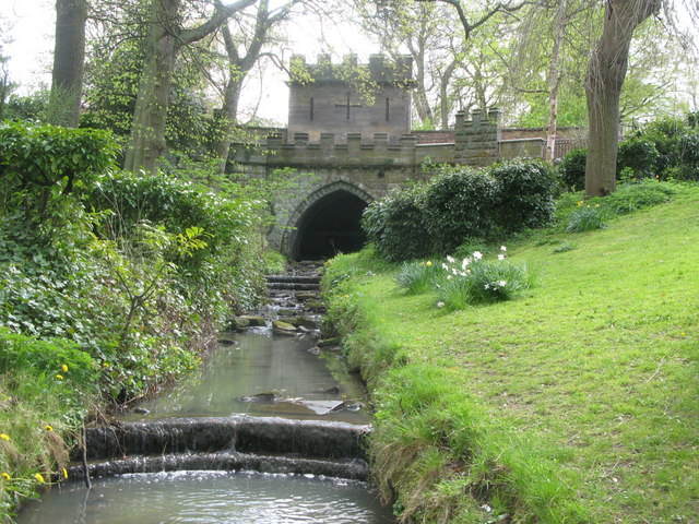
| Bridge over Halgut Burn in Grounds of Hexham House | 1042590 | II* | C13th | The Sele |
| Burn Brae House | 1042559 | II | ||
| Bursewell House | 1370799 | II | ||
| Burton's | 1203728 | II | ||
| Catholic Club | 1042560 | II | ||
| Causeway and Bridge over Cockshaw Burn on Drive to Breckon Hill Farm | 1042636 | II | ||
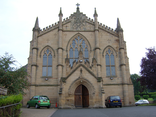
| Church of St Mary (Roman Catholic) | 1042558 | II* | 1830 | |
| Cockshaw House | 1203685 | II | ||
| Cotfield House | 1042568 | II | ||
| County Hotel | 1042548 | II | ||
| Courtyard Walls in Front of Temperley Place (Number 5) | 1281443 | II | ||
| Cowshed and Granary to West of Bagraw Farmhouse | 1042575 | II | ||
| Craig's Barn | 1203970 | II | ||
| Crenellated Retaining Wall to East of the Old Grammar School | 1370752 | II | ||
| Crenellated Retaining Wall to North East of Prospect House | 1203567 | II | ||
| Delegate Cottage | 1042580 | II | ||
| Dipton Mill Bridge | 1045332 | II | ||
| Drinking Fountain to South of Central Range of Hexham County Primary Infant and Junior School | 1042514 | II | ||
| Duke's House, Including Wall of Terrace to South | 1042581 | II | ||
| East Peterel Field Farmhouse | 1370781 | II | ||
| Entrance Gateway to the Henry King Memorial Almshouses | 1042557 | II* | ||
| Fairshaw Farmhouse | 1204009 | II | ||
| Fandango's Club | 1042554 | II* | ||
| Former North Eastern Hotel | 1042639 | II | ||
| Former Post Office | 1204130 | II | ||
| Former Stable Building to North West of Prospect House | 1042599 | II | ||
| Former Tannery Building at Ny 93296462 | 1042525 | II | ||
| Garden Wall at Rear of Temperley Place (Number 5) Following Footpath to the Seal | 1042571 | II | ||
| Garden Wall Between Garden Cottage and Duke's House | 1370803 | II | ||
| Garden Wall Between Temperley Place | 1203951 | II | ||
| Garden Walls to South of Station Cottages | 1359123 | II | ||
| Garden Walls, Spital Park | 1360811 | II | ||
| Gates Opposite North Transept | 1042612 | II | ||
| Gateway to Roman Catholic Cemetery | 1370791 | II | ||
| Glover's Pant | 1042572 | II | ||
| Goods Shed to East of Hexham Railway Station | 1096878 | II | ||
| Hackwood | 1042619 | II | ||
| Haliwell Dene | 1203688 | II | ||
| Hall Bank House | 1203565 | II | ||
| Hallgarth House | 1281492 | II | ||
| Hallstile Cottages | 1370790 | II | ||
| Heart of All England Tavern | 1281358 | II | ||
| Hencotes House | 1042563 | II | ||
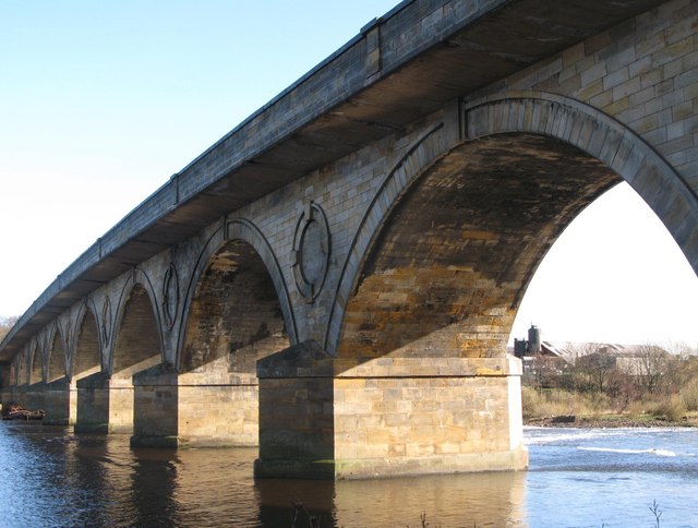
| Hexham Bridge | 1042629 | II* | 1793 | |
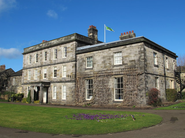
| Hexham House | 1281531 | II* | 1723 | |
| Hexham Middle School | 1370789 | II | 1910 | |
| Hexham Primary Infants and Junior School | 1204210 | II | ||
| Hexham Railway Station | 1370815 | II | ||
| Hexham War Memorial | 1204219 | II | 1921 | The Sele (park) |
| High Shield House | 1203721 | II* | ||
| Highford Farmhouse | 1370797 | II | ||
| Highside Farmhouse | 1042637 | II | ||
| Highwood Farmhouse | 1370813 | II | ||
| Holy Island Cottage | 1203992 | II* | ||
| Holy Island House | 1042573 | II* | ||
| House of Correction | 1042611 | II | c.1820 | Chareway Lane |
| K6 Telephone Kiosk | 1052203 | II | ||
| K6 Telephone Kiosk | 1052204 | II | ||
| K6 Telephone Kiosk | 1260707 | II | ||
| Lloyds Bank | 1204136 | II | ||
| Low Barns | 1042631 | II | ||
| Low Street Wall in Front of Temperley Place (Number 4) | 1042569 | II | ||
| Manor Cottage | 1042593 | II | ||
| Middle Shield House | 1370780 | II* | ||
| Midland Bank | 1042608 | II | ||
| National Westminster Bank | 1042600 | II | ||
| No. 16 - 16a Market Place, Incorporating Remains of St Mary's Church | 1396106 | II | ||
| Northumberland Fusiliers' War Memorial Gateway | 1281571 | II* | C17th | |
| Oakerland | 1370814 | II | ||
| Orchard House | 1370826 | II* | ||
| Orchard Place | 1204143 | II | ||
| Overtrack Signal Box to East of Hexham Railway Station | 1042523 | II | 1896 | |
| Pant | 1281400 | II | 1901 | aka Temperley Memorial Fountain |
| Prospect House | 1042641 | II | ||
| Quatre Bras | 1042517 | II | ||
| Queens Hall and Town Hall Buildings | 1042607 | II | 1866 | Now Queens Hall Arts Centre, Library & Tourist Info. |
| Railings to North East Side of the Old Grammar School | 1370751 | II | ||
| Red Lion Cottage | 1370779 | II | ||
| Remains of Former Number 20 | 1042604 | II | ||
| Retaining Wall in Front of Numbers 9 to 17 | 1370770 | II | ||
| Roman Catholic Presbytery | 1042605 | II | ||
| Sele House | 1042515 | II | ||
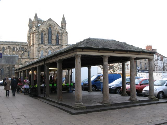
| Shambles | 1370800 | II* | 1766 | Market Place |
| Shieldcroft | 1042579 | II | ||
| St Andrew's Cemetery Gates | 1042518 | II | ||
| St Andrew's Cemetery Mortuary Chapels | 1281281 | II | ||
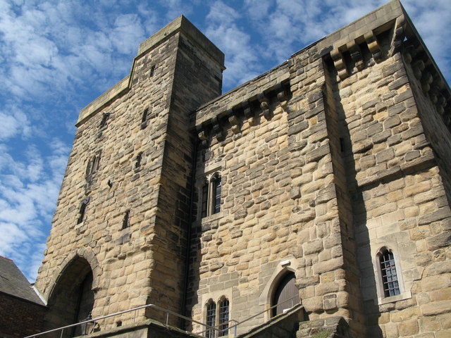
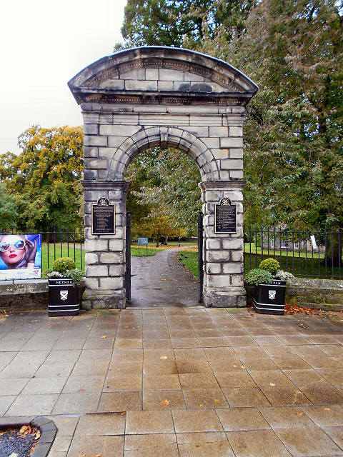
| St Wilfrid's Gateway, the Priory gatehouse | 1042616 | I | c.1160 | Cowgarth |
| Stable Block to North West of Summer Rods | 1042634 | II | ||
| Stable of the Spital | 1042516 | II* | ||
| Station Cottages | 1042522 | II | ||
| Statue of Lieutenant Colonel GE Benson at Southern End of Beaumont Street | 1370777 | II | 1910 | |
| Storehouse Adjacent to East of Number 12 | 1203829 | II | ||
| Summer Rods | 1042633 | II | ||
| Sunniside Farmhouse | 1042583 | II | ||
| Swallowship House | 1370804 | II | ||
| Temperley Place | 1042567 | II | ||
| Temperley Place | 1042570 | II | ||
| Temperley Place | 1203962 | II | ||
| The 'Tannery', to South East of High Shield House | 1042618 | II | ||
| The Claustral Buildings of the Former Augustinian Priory of St Andrew Now Incorporated in Hexham Court House and Hexham House Clinic... | 1370776 | I | C13th | Ruins incorporated into later buildings |
| The Farmhouse | 1203676 | II | ||
| The Former Hexham Hydropathic (now part of Queen Elizabeth High School) | 1042638 | II | ||
| The Foundary | 1204259 | II | ||
| The Leazes | 1204227 | II | ||
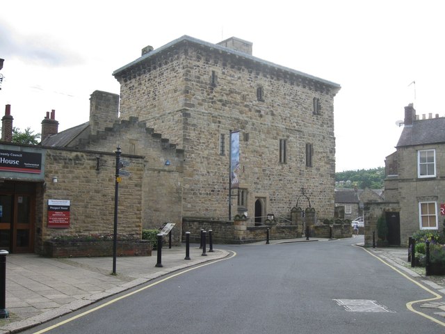
| The Manor Office | 1281526 | I | 1330 | |
| The Moot Hall | 1042577 | I | C14th | |
| The Old Globe Public House | 1042601 | II | ||
| The Old Grey Bull Public House | 1370772 | II | ||
| The Old Queen Elizabeth Grammar School | 1281643 | II* | 1599 | |
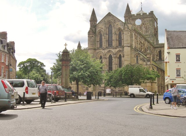
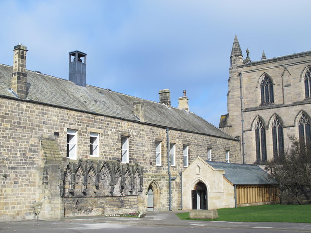
| The Priory Church of St Andrews' | 1042576 | I | C7th | aka Hexham Abbey |
| The Ropery, Now the Argyle Cafe | 1042524 | II | ||
| The Royal Hotel | 1281367 | II | ||
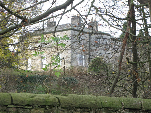
| The Spital | 1370811 | I | 1802 | House |
| Tomb of John Ridley | 1203682 | II | ||
| Trinity Methodist Church and Church Hall | 1203665 | II | c.1880 | |
| Two Lodges at St Andrew's Cemetery | 1204273 | II | ||
| Wall 250 Yards Long Screening Oakerland from Road | 1042520 | II | ||
| Wall on North Side | 1281587 | II | ||
| Wall to Bowling Green, from Hexham House to Priory Gateway | 1042589 | II | ||
| Walls to Path Leading to Gaprigg Lane | 1370801 | II | ||
| Watch Kurrick Farmhouse | 1204299 | II | ||
| Water Tower at Swallowship House | 1042582 | II | ||
| Water Tower to South East of Hexham Railway Station | 1042521 | II | ||
| Wentworth Place | 1203820 | II | ||
| Westburn | 1042609 | II | ||
| Westwood Farmhouse | 1042630 | II | ||
| Woodley Field Farmhouse | 1042632 | II | ||
| Hexham Bridge | 1002905 | n/a | Scheduled Monument | |
| Hexham Manor Office (or gaol) | 1006512 | n/a | Scheduled Monument | |
| Remains of medieval priory and Anglo-Saxon monastery under and around Hexham Abbey and its precincts | 1006593 | n/a | Anglo Saxon | Scheduled Monument |
| Hexham Conservation Area | - | n/a | Conservation Area |
Primary source: the National Heritage List for England - NHLE is the register of nationally protected historic buildings and sites in England, including listed buildings, scheduled monuments, protected wrecks, registered parks and gardens, and battlefields. The list is maintained by Historic England. Check NHLE for updates and new entries. Secondary sources: British Listed Buildings and Keys to the Past.
Co-Curate Page
Hexham Abbey
- Overview About Hexham Abbey Map Inside Street View "There has been a church on this site for more than 1,300 years, since Queen Etheldreda made a grant of lands to …
Co-Curate Page
Old Gaol
- Overview About Hexham Old Gaol Map Street View Built c.1330 and one of the first purpose-built prisons in Britain. Today the Old Gaol is a museum, where you can see …
Co-Curate Page
The Spital
- Overview Map The Spital (house) in Hexham was built in 1802 on the site of the mediaeval St Giles' Hospital.[1] It was the centre of a large estate, with grounds and …
Co-Curate Page
Hexham Bridge
- Overview Map Street View Hexham Bridge carries the A6079 road over the River Tyne at Hexham. The nine arched stone bridge was built in 1793, to the designes of John …
Co-Curate Page
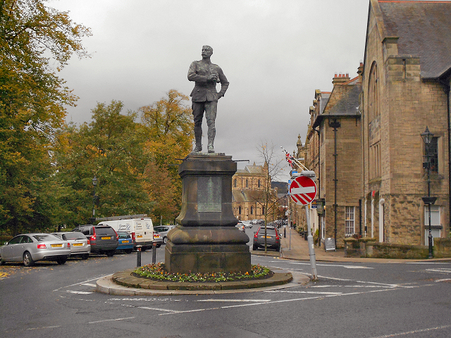
Benson Monument
- Overview Map Street View This bronze statue of Lieutenant-Colonel George Elliott Benson is located at the south end of Beaumont Street in Hexham. Benson served with the Royal Regiment of …
Co-Curate Page
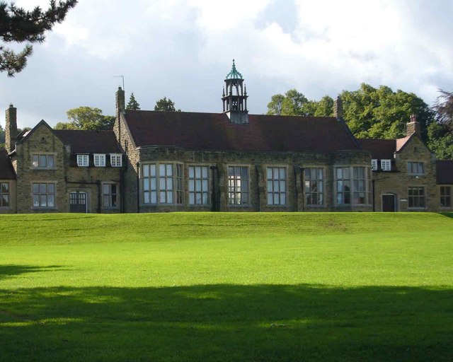
Hexham Middle School
- Overview About the School Map Street View Hexham Middle School is a community school located on Wanless Lane in Hexham. The school is part of an academy trust (Hadrian Learning …
Co-Curate Page
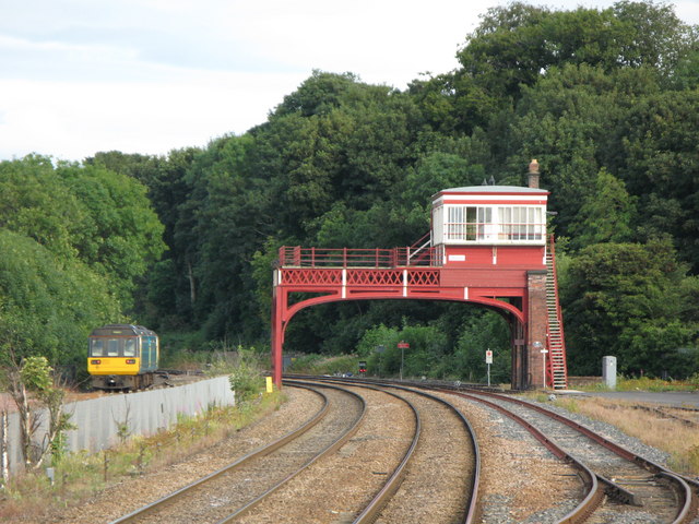
Signal Box
- The overhead railway signal box at Hexham was built in c.1896 by the Newcastle and Carlisle Railway. This, and the signal box at Wylam, are the only 2 surviving examples of this type of …
Co-Curate Page
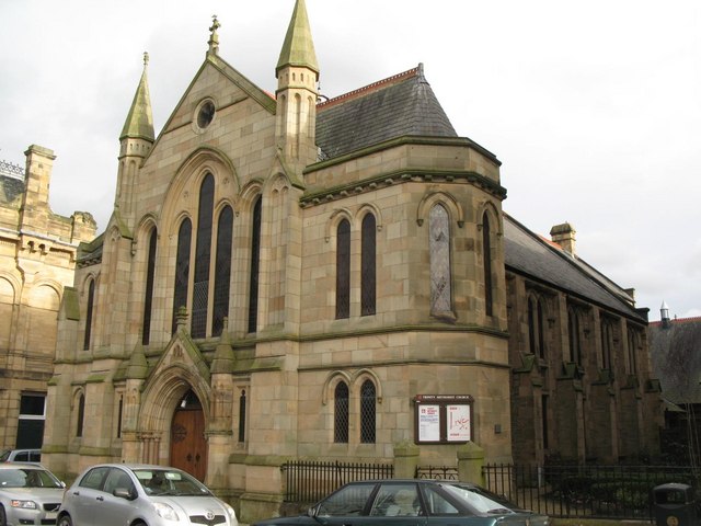
Trinity Methodist Church
- Overview Map Street View Trinity Methodist Church is located on Beaumont Street, Hexham. The church was built in c.1880 and is Grade II listed on the National Heritage List for …
Co-Curate Page
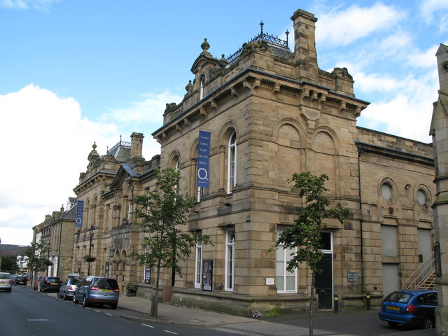
Queen's Hall, Hexham
- Overview Map Street View The Queens Hall and Town Hall Buildings on Beaumont Street in Hexham were built in 1866. Today the building hosts the Queen's Hall Arts Centre, Library …
Co-Curate Page
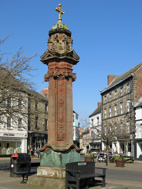
Temperley Memorial Fountain, Hexham
- Overview Map Street View The Temperley memorial fountain is located in the Market Place in Hexham. The large ornamental red sandstone monument was built in 1901 by W.H. Knowles (Architect), G.W. …
Co-Curate Page
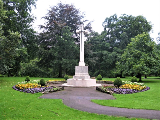
War Memorial, Hexham
- Overview Map Street View The Cenotaph in Hexham is located on east side of The Sele / Abbey Park, by the Beaumont Street entrance. The white Portland stone memorial was …
Co-Curate Page
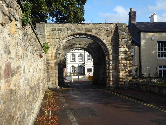
St Wilfrid's Gateway, Hexham
- Overview Map Street View St Wilfrid's Gateway is located on Cowgarth, near it's junction with Market Street in Hexham. The stone gateway dates from c.1160 and is what remains of …
Co-Curate Page
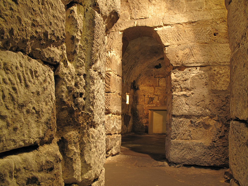
Claustral Buildings of the Former Priory, Hexham
- "The Claustral Buildings of the former Augustinian Priory of St Andrew now incorporated in Hexham Court House and Hexham House Clinic (formerly listed as Remains of the Abbey) - C13 Vestibule …
Co-Curate Page
St Mary's RC Church, Hexham
- Overview Map Street View "For the period 1721 until 1827, Hexham had two Catholic chapels, a Dominican chapel on Battle Hill and a secular chapel in Cockshaw. In 1827, it …
Co-Curate Page
The Shambles, Hexham
- Overview Map Street View The Shambles is a covered market in Hexham, built in 1766 at the expence of Sir Walter Blackett. Located in the Market Place, the Shambles are …
Co-Curate Page
Gilesgate Bridge over Halgut Burn
- This bridge over Halgut Burn in the Sele in Hexham dates from the 13th century, with a mid-19th century crenelated parapet and overbuilding. It is located in the former grounds …
Co-Curate Page
Remains of medieval priory around Hexham Abbey
- Map showing the Scheduled Monument Area The remains of the medieval priory and Anglo-Saxon monastery under and around Hexham Abbey and its precincts are a Scheduled Monument (legally protected). This …

Co-Curate Page
Hexham Abbey
- Overview About Hexham Abbey Map Inside Street View "There has been a church on this site for more than 1,300 years, since Queen Etheldreda made a grant of lands to …
Co-Curate Page
Old Gaol
- Overview About Hexham Old Gaol Map Street View Built c.1330 and one of the first purpose-built prisons in Britain. Today the Old Gaol is a museum, where you can see …
Co-Curate Page
The Spital
- Overview Map The Spital (house) in Hexham was built in 1802 on the site of the mediaeval St Giles' Hospital.[1] It was the centre of a large estate, with grounds and …
Co-Curate Page
Hexham Bridge
- Overview Map Street View Hexham Bridge carries the A6079 road over the River Tyne at Hexham. The nine arched stone bridge was built in 1793, to the designes of John …
Co-Curate Page
Benson Monument
- Overview Map Street View This bronze statue of Lieutenant-Colonel George Elliott Benson is located at the south end of Beaumont Street in Hexham. Benson served with the Royal Regiment of …
Co-Curate Page
Hexham Middle School
- Overview About the School Map Street View Hexham Middle School is a community school located on Wanless Lane in Hexham. The school is part of an academy trust (Hadrian Learning …
Co-Curate Page
Signal Box
- The overhead railway signal box at Hexham was built in c.1896 by the Newcastle and Carlisle Railway. This, and the signal box at Wylam, are the only 2 surviving examples of this type of …
Co-Curate Page
Trinity Methodist Church
- Overview Map Street View Trinity Methodist Church is located on Beaumont Street, Hexham. The church was built in c.1880 and is Grade II listed on the National Heritage List for …
Co-Curate Page
Queen's Hall, Hexham
- Overview Map Street View The Queens Hall and Town Hall Buildings on Beaumont Street in Hexham were built in 1866. Today the building hosts the Queen's Hall Arts Centre, Library …
Co-Curate Page
Temperley Memorial Fountain, Hexham
- Overview Map Street View The Temperley memorial fountain is located in the Market Place in Hexham. The large ornamental red sandstone monument was built in 1901 by W.H. Knowles (Architect), G.W. …
Co-Curate Page
War Memorial, Hexham
- Overview Map Street View The Cenotaph in Hexham is located on east side of The Sele / Abbey Park, by the Beaumont Street entrance. The white Portland stone memorial was …
Co-Curate Page
St Wilfrid's Gateway, Hexham
- Overview Map Street View St Wilfrid's Gateway is located on Cowgarth, near it's junction with Market Street in Hexham. The stone gateway dates from c.1160 and is what remains of …
Co-Curate Page
Claustral Buildings of the Former Priory, Hexham
- "The Claustral Buildings of the former Augustinian Priory of St Andrew now incorporated in Hexham Court House and Hexham House Clinic (formerly listed as Remains of the Abbey) - C13 Vestibule …
Co-Curate Page
St Mary's RC Church, Hexham
- Overview Map Street View "For the period 1721 until 1827, Hexham had two Catholic chapels, a Dominican chapel on Battle Hill and a secular chapel in Cockshaw. In 1827, it …
Co-Curate Page
The Shambles, Hexham
- Overview Map Street View The Shambles is a covered market in Hexham, built in 1766 at the expence of Sir Walter Blackett. Located in the Market Place, the Shambles are …
Co-Curate Page
Gilesgate Bridge over Halgut Burn
- This bridge over Halgut Burn in the Sele in Hexham dates from the 13th century, with a mid-19th century crenelated parapet and overbuilding. It is located in the former grounds …


