Topics > Civil Parishes in Cumbria > Eskdale Civil Parish > Historic Buildings and Monuments in Eskdale Civil Parish
Historic Buildings and Monuments in Eskdale Civil Parish
Listed buildings and scheduled monuments in Eskdale Civil Parish, Cumbria, from the National Heritage List for England[1]. Use the Search (below) if looking for a specific building / monument.
| Structure | List No. | Grade | Built~ | Note |
|---|---|---|---|---|
| Barn and Shippon at North End of Farmyard at Long Rigg Farm | 1318866 | II | ||
| Barn to North West of Bridge End Farmhouse | 1336053 | II | ||
| Barn to South West of Whillanside | 1336055 | II | ||
| Barn west of Forge House | 1410961 | II | ||
| Boot House and Whillanside | 1086656 | II | ||
| Boundary Wall to Farmyard at Long Rigg Farm | 1253850 | II | ||
| Bridge End Farmhouse | 1086653 | II | ||
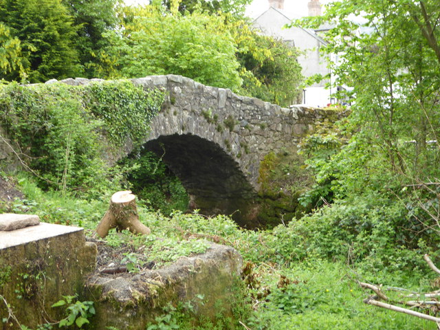
| Bridge over Whillan Beck to South West of Corn Mill | 1086654 | II | C18th | Former packhorse bridge |
| Brotherilkeld Farmhouse with Adjoining Stable and Barn | 1253896 | II | ||
| Building to South West of Corn Mill on East Side of Road at North End of Bridge | 1336054 | II | ||
| Cart Shed and Loose Boxes to North East of Farmyard at Long Rigg Farm | 1318868 | II | ||
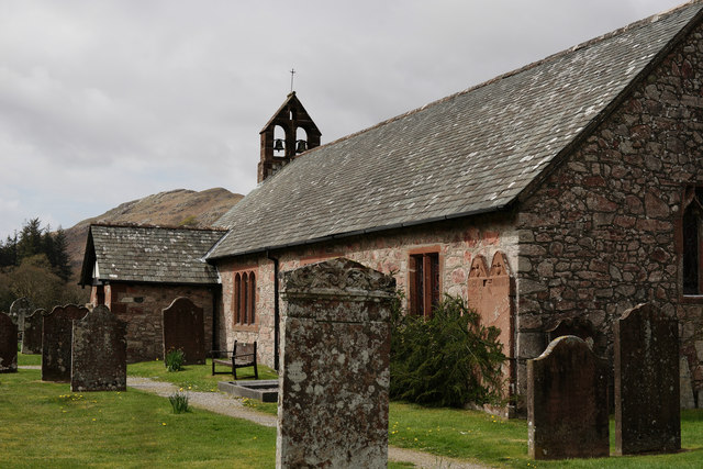
| Church of St Catherine | 1086695 | II | C14th | South of Boot |
| Cottage and Barn to North of Dalegarth Hall | 1261575 | II | ||
| Dalegarth Hall | 1253897 | II | C16th | Former manor house |
| Doctor Bridge | 1336032 | II | C17th | Eskdale. Widened C18th |
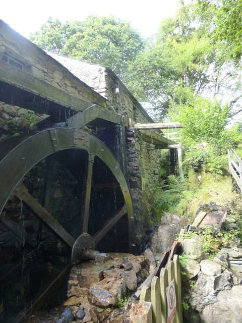
| Eskdale Corn Mill | 1086655 | II* | C16th | |
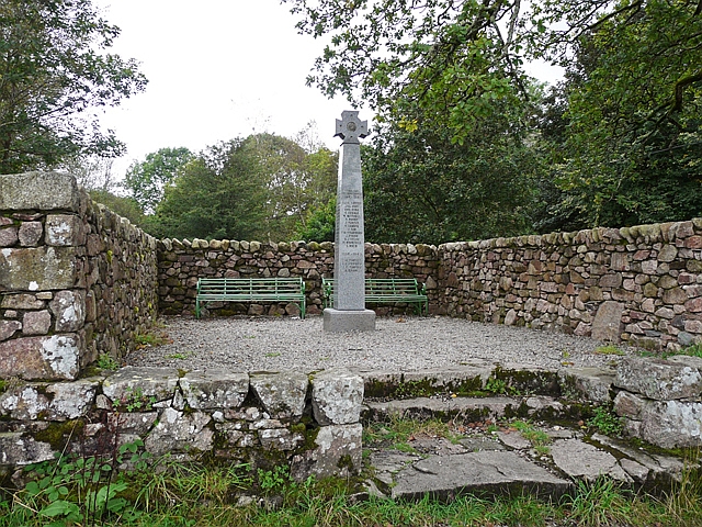
| Eskdale War Memorial | 1441555 | II | 1920 | |
| Forge House with Attached Barn, Stable and Byres | 1346565 | II | ||
| Former Farmhouse and Attached Barn | 1318889 | II | ||
| Former Smithy and Cottage to North of Farmyard at Long Rigg Farm | 1261563 | II | ||
| Gate House (Outward Bound School) | 1086657 | II | 1896 | Eskdale Green. |
| K6 Telephone Kiosk | 1086647 | II | ||
| Long Rigg Farmhouse | 1145930 | II | ||
| Manure Shed in Centre of Farmyard at Long Rigg Farm | 1145933 | II | ||
| Mite Villa | 1145934 | II | ||
| Multi Functional Building at South East Corner of Farmyard at Long Rigg Farm | 1145932 | II | ||
| Pigsties at North East Corner of Farmyard at Long Rigg Farm | 1318867 | II | ||
| Stable Block on North West Side of Farmyard at Long Rigg Farm | 1145931 | II | ||
| Yattus | 1086658 | II | ||
| Pike How prehistoric cairnfield and associated field system 320m south west of High Ground | 1019554 | n/a | Scheduled Monument | |
| Prehistoric cairnfield and associated field system 800m north west and 800m north of Woodend Bridge | 1019557 | n/a | Scheduled Monument | |
| Prehistoric cairnfield, field system, two funerary cairns, a Romano-British farmstead, field system and a post-medieval haematite mine at Brantrake Moss | 1019990 | n/a | Scheduled Monument | |
| Maiden Castle round cairn, Burnmoor | 1008532 | n/a | Scheduled Monument | |
| Cairnfield including a funerary cairn, standing stone and three stone banks south of Eller How, Burnmoor | 1008538 | n/a | Scheduled Monument | |
| Prehistoric enclosure north of Little Pie, Burnmoor | 1008533 | n/a | Scheduled Monument | |
| Prehistoric cairnfield and associated field system north of Pike How, 650m west of High Ground | 1019555 | n/a | Scheduled Monument | |
| Green How West unenclosed prehistoric hut circle settlement 540m NNE of Birkerthwaite | 1019618 | n/a | Scheduled Monument | |
| Prehistoric enclosure containing ten clearance cairns south west of Boat How, Burnmoor | 1008537 | n/a | Scheduled Monument | |
| Prehisitoric cairnfield 850m north west of Woodend Bridge | 1019558 | n/a | Scheduled Monument | |
| Great Crag prehistoric cairnfield and associated field system 710m south east of Birkerthwaite | 1019613 | n/a | Scheduled Monument | |
| Prehistoric cairnfield 840m east of Birkerthwaite | 1019614 | n/a | Scheduled Monument | |
| Smallstone Beck prehistoric cairnfield 410m east of Birkerthwaite | 1019615 | n/a | Scheduled Monument | |
| Prehistoric cairnfield and associated field system 730m ENE of Birkerthwaite | 1019616 | n/a | Scheduled Monument | |
| Prehistoric cairnfield, hut circle settlement and associated field system 290m south east of Low Birker Tarn | 1019617 | n/a | Scheduled Monument | |
| Prehistoric cairnfield immediately south of Birkerthwaite | 1019619 | n/a | Scheduled Monument | |
| Prehistoric cairnfield and associated field system 630m east of the confluence of Hall Beck and Devoke Water | 1019928 | n/a | Scheduled Monument | |
| Prehistoric cairnfield south west of Water Crag, 290m north west of the confluence of Linbeck Gill and Devoke Water | 1019552 | n/a | Scheduled Monument | |
| Prehistoric cairnfield 420m south east of the triangulation pillar on Rough Crag | 1019553 | n/a | Scheduled Monument | |
| Hare Gill prehistoric cairnfield, hut circle settlement and associated field system 715m SSE of Fisher Gate | 1019556 | n/a | Scheduled Monument | |
| Prehistoric cairnfield, associated field system and hut circle east of Water Crag | 1019980 | n/a | Scheduled Monument | |
| Prehistoric enclosure, hut circle and adjacent cairnfield east of Whillan Beck, Burnmoor | 1008534 | n/a | Scheduled Monument | |
| Prehistoric enclosure containing three hut circles and eight clearance cairns and an adjacent hut circle and cairnfield north east of Boat How, Burnmoor | 1008536 | n/a | Scheduled Monument | |
| Cairnfield including a prehistoric enclosure, 5 stone circles, 10 funerary cairns, 6 stone banks, 2 stone walls, a lynchet and a trackway on Burnmoor | 1008539 | n/a | Scheduled Monument | |
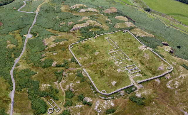
| Hardknott Roman fort, bath-house, parade ground and tribunal, 4 Roman roads, Roman quarries and 3 cairns | 1009349 | n/a | Roman | Scheduled Monument |
| Cairnfield south of Straighthead Gill, Burnmoor | 1008535 | n/a | Scheduled Monument. Partly in this parish. | |
| Roman road from Wrynose Bottom to Hardknott Ford | 1003266 | n/a | Scheduled Monument |
Primary source: the National Heritage List for England - NHLE is the register of nationally protected historic buildings and sites in England, including listed buildings, scheduled monuments, protected wrecks, registered parks and gardens, and battlefields. The list is maintained by Historic England. Check NHLE for updates and new entries. Secondary sources: British Listed Buildings.
Co-Curate Page
Church of St Catherine
- Overview About St Catherine's Church Map Street View St. Catherine's Church is located close to the River Esk, about half a mile south of the village of Boot in Eskdale, …
Co-Curate Page
Eskdale Mill
- Overview Map Street View Eskdale Mill is located by Whillan Beck in the village of Boot in Eskdale, Cumbria. Eskdale Mill is one of the oldest water powered corn mills …
Co-Curate Page
Eskdale War Memorial
- Overview Map Street View The Eskdale War Memorial is located at a road junction between Boot and Dalegarth in Eskdale. The memorial was unveiled on the 16th of May 1920 …
Co-Curate Page
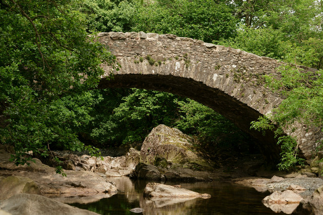
Bridge over Whillan Beck
- Overview Map Street View The stone bridge over Whillan Beck, by Esksdale Mill in Boot, was originally built as packhorse bridge in the early 18th century.[1] The bridge is Grade …
Co-Curate Page
Doctor Bridge, Eskdale
- Overview Map Street View Doctor Bridge is a stone road bridge over the River Esk in Eskdale. It was originally a packhorse bridge built in the 17th century. It's name …
Co-Curate Page
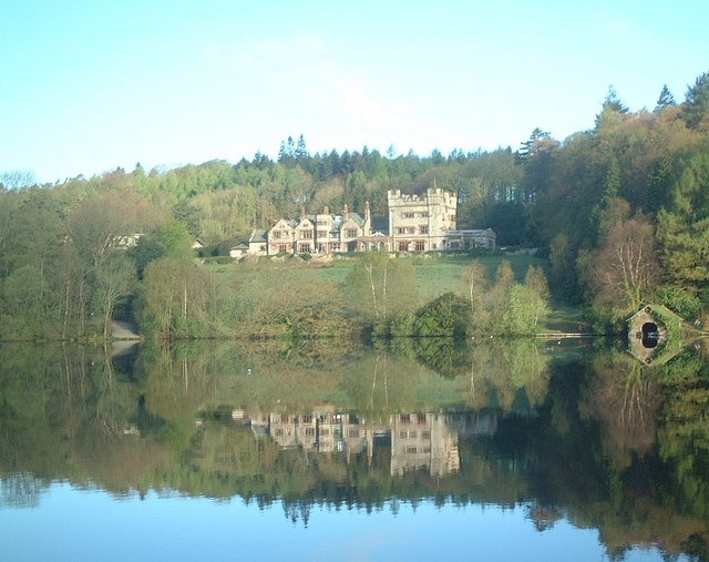
Outward Bound Eskdale
- Overview Map Outward Bound Eskdale is run by The Outward Bound Trust. The centre is located at the north-east side of Eskdale Green, by a tarn (lake). The building is …
Co-Curate Page
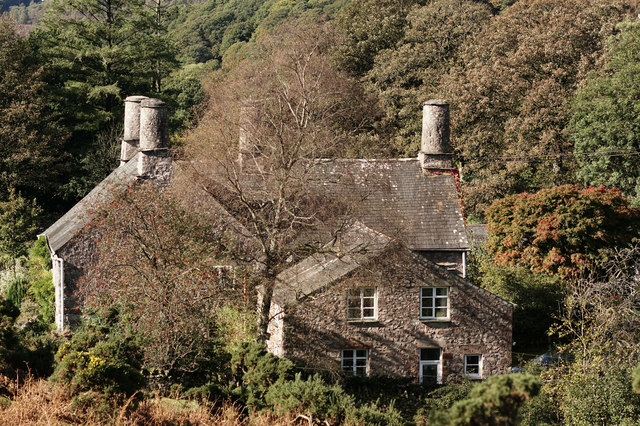
Dalegarth Hall, Eskdale
- Overview Map Street View Dalegarth Hall, near Boot in Eskdale is a former manor house, on a site occupied since the 14th century. The present building dates from the 16th …
Co-Curate Page
Hardknott Roman Fort
- Overview Map Street View Aerial View The well-preserved remains of Hardknott Roman Fort (Mediobogdum) are located about 5 miles east of the village of Eskdale Green in Cumbria. It was …

Co-Curate Page
Church of St Catherine
- Overview About St Catherine's Church Map Street View St. Catherine's Church is located close to the River Esk, about half a mile south of the village of Boot in Eskdale, …
Co-Curate Page
Eskdale Mill
- Overview Map Street View Eskdale Mill is located by Whillan Beck in the village of Boot in Eskdale, Cumbria. Eskdale Mill is one of the oldest water powered corn mills …
Co-Curate Page
Eskdale War Memorial
- Overview Map Street View The Eskdale War Memorial is located at a road junction between Boot and Dalegarth in Eskdale. The memorial was unveiled on the 16th of May 1920 …
Co-Curate Page
Bridge over Whillan Beck
- Overview Map Street View The stone bridge over Whillan Beck, by Esksdale Mill in Boot, was originally built as packhorse bridge in the early 18th century.[1] The bridge is Grade …
Co-Curate Page
Doctor Bridge, Eskdale
- Overview Map Street View Doctor Bridge is a stone road bridge over the River Esk in Eskdale. It was originally a packhorse bridge built in the 17th century. It's name …
Co-Curate Page
Outward Bound Eskdale
- Overview Map Outward Bound Eskdale is run by The Outward Bound Trust. The centre is located at the north-east side of Eskdale Green, by a tarn (lake). The building is …
Co-Curate Page
Dalegarth Hall, Eskdale
- Overview Map Street View Dalegarth Hall, near Boot in Eskdale is a former manor house, on a site occupied since the 14th century. The present building dates from the 16th …


