Topics > Civil Parishes in Cumbria > Dent Civil Parish, Sedbergh > Historic Buildings and Monuments in Dent Civil Parish
Historic Buildings and Monuments in Dent Civil Parish
Listed buildings and scheduled monuments in Dent Civil Parish, Cumbria, from the National Heritage List for England[1]. Use the Search (below) if looking for a specific building / monument.
| Structure | List No. | Grade | Built~ | Note |
|---|---|---|---|---|
| No. 2, Queens Square | 1383995 | II | ||
| Acre Farmhouse and Attached Farm Buildings at East and West Ends | 1383814 | II | 1711 | |
| Allen Haw and Barn Adjoining at East End | 1383816 | II | C18th | |
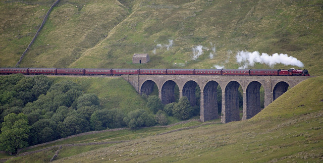
| Artengill Viaduct | 1383817 | II | 1875 | Settle & Carlisle Railway |
| Backstone Gill Cottage | 1383818 | II | C18th | |
| Bank Barn Approximately 5 Metres South of Acre Farmhouse | 1383815 | II | C18th | |
| Bank House | 1383977 | II | C19th | |
| Barn (Called Hazel Haw) Approximately 75 Metres North of Lunds Farmhouse | 1383907 | II | C17th | |
| Barn Adjoining to South East of Hall Bank Farmhouse | 1383885 | II | ||
| Barn Approximately 10 Metres North East of Geslings | 1383873 | II | ||
| Barn Approximately 10 Metres South of Hewthwaite Farmhouse | 1383889 | II | ||
| Barn Approximately 10 Metres South West of Biggerside Farmhouse | 1383821 | II | ||
| Barn Approximately 100 Metres to East of Whernside Manor | 1383953 | II | ||
| Barn Approximately 15 Metres East of Hacra Farmhouse | 1383882 | II | ||
| Barn Approximately 15 Metres West of Peggles Wright Farmhouse | 1383926 | II | ||
| Barn Approximately 2 Metres East of Dairy Cottage | 1383843 | II | ||
| Barn Approximately 20 Metres North of Howgill House | 1383897 | II | ||
| Barn Approximately 3 Metres to South East of Mire House | 1383921 | II | ||
| Barn Approximately 30 Metres South of Rash House on Opposite Side of Lane | 1383930 | II | ||
| Barn Approximately 30 Metres South of Scotchergill Farmhouse | 1383936 | II | ||
| Barn Approximately 4 Metres North of Hewthwaite | 1383888 | II | ||
| Barn Approximately 4 Metres North West of Moser Hill Farmhouse | 1383924 | II | ||
| Barn Approximately 5 Metres North East of Burton Hill Farmhouse | 1383830 | II | ||
| Barn Approximately 5 Metres North West of East Banks Farmhouse | 1383854 | II | ||
| Barn Approximately 5 Metres North West of Gawthrop Hall | 1383965 | II | ||
| Barn Approximately 5 Metres South of Gale Garth Farmhouse | 1383865 | II | ||
| Barn Approximately 5 Metres West of Craggs Hill | 1383841 | II | ||
| Barn Approximately 5 Metres West of Ellers | 1383860 | II | ||
| Barn Approximately 50 Metres South East of Combe House | 1383837 | II | ||
| Barn Approximately 50 Metres West of Lunds Farmhouse | 1383908 | II | ||
| Barn Attached to West End of Birchentree Farmhouse | 1383823 | II | ||
| Barn Linked to West End of Gale Garth Farmhouse | 1383866 | II | ||
| Barn to North East of Blake Rigg | 1383957 | II | ||
| Barn to North of West Stonehouse Farmhouse | 1383951 | II | ||
| Barn to North West of East Clint | 1383857 | II | ||
| Barn to South West of High Hall Farmhouse | 1383894 | II | ||
| Barras House | 1383961 | II | ||
| Barth Bridge | 1383802 | II | ||
| Basil Busk | 1383819 | II | ||
| Beech Hill Cottage | 1383803 | II | ||
| Biggerside Farmhouse | 1383820 | II* | 1690 | |
| Birchentree Farmhouse | 1383822 | II | ||
| Blake Rigg | 1383956 | II | ||
| Blands Farmhouse | 1383824 | II | ||
| Blea Beck Approximately 160 Metres North of Hacra | 1383825 | II | ||
| Boundary Stone on West Side of Road Approximately 20 Metres South of Lane to Catholes | 1383826 | II | ||
| Brackensgill and Attached Barn to East | 1383827 | II | ||
| Broadfield House and Broadfield Farmhouse | 1383828 | II | ||
| Brookside | 1383962 | II | ||
| Building (Former Workers Barracks) Approximately 100 Metres South South East of Dent Railway Station | 1383849 | II | ||
| Burton Hill Farmhouse Including Adjoining Outbuilding | 1383829 | II* | C16th | |
| Burtons | 1383806 | II | ||
| Cage Farmhouse | 1383832 | II | ||
| Carlow Hill | 1383833 | II | ||
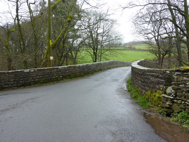
| Church Bridge | 1383805 | II | C18th | Dent. Over River Dee. |
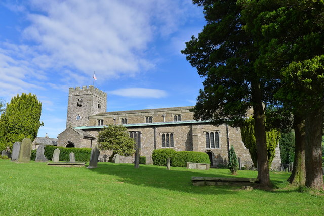
| Church of St Andrew | 1383978 | I | C12th | Dent |
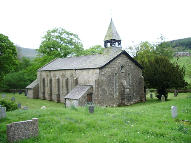
| Church of St John the Evangelist | 1383834 | II | 1838 | Cowgill |
| Combe House | 1383836 | II | ||
| Congregational Manse | 1383958 | II | ||
| Coventree Farmhouse and Former House Attached at South End | 1383807 | II | ||
| Cow Dub Farmhouse and Attached Barn | 1383838 | II | ||
| Cowgill Bridge | 1383839 | II | 1702 | Cowgill |
| Craggs Hill | 1383840 | II | ||
| Dairy Cottage and Attached Stable | 1383842 | II | ||
| Dee Side Farmhouse | 1383845 | II | ||
| Dee Side House Youth Hostel | 1383846 | II | House - former Youth Hostel | |
| Deepdale Head Farmhouse | 1383808 | II | ||
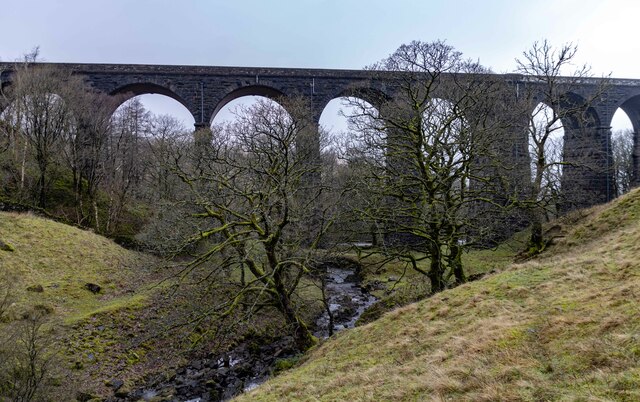
| Dent Head Viaduct | 1383847 | II | 1875 | Settle & Carlisle Railway |
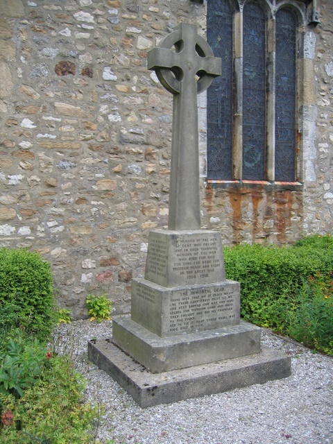
| Dent War Memorial | 1457103 | II | 1921 | By St Andrew's Church, Dent |
| Docklesyke Farmhouse | 1383809 | II | ||
| Dockra Bridge over Cowgill Beck | 1383852 | II | C18th | Cowgill |
| East Banks Farmhouse | 1383853 | II | ||
| East Clint | 1383856 | II | ||
| East Stonehouse | 1383858 | II | ||
| Edmonsons | 1383981 | II | ||
| Ellers | 1383859 | II | ||
| Ewegales Bridge | 1383861 | II | C18th | Cowgill |
| Far End Cottage and Barn Attached to West | 1383963 | II | ||
| Field Barn on South Side of Road Approximately 150 Metres South West of High Chapel (Not Included) | 1383862 | II | ||
| Fletchers Farmhouse | 1383863 | II | ||
| Gale Garth Farmhouse | 1383864 | II | ||
| Gap Farmhouse | 1383867 | II | ||
| Gate | 1383869 | II | ||
| Gate Arch at South East Corner of Garden of Gate | 1383870 | II | ||
| Gate Piers and Gates to Churchyard of Church of St John the Evangelist | 1383835 | II | ||
| Gateway to South Side of Churchyard of Church of St Andrew | 1383979 | II | ||
| Gawthrop Hall | 1383964 | II | ||
| Gawthrop Villa | 1383966 | II | ||
| Geslings | 1383872 | II | ||
| Gibbs Hall | 1383874 | II | ||
| Gibbs Hall Farmhouse | 1383875 | II | ||
| Greenwell | 1383878 | II | ||
| Hacker Gill Farmhouse | 1383879 | II | ||
| Hacra Farmhouse | 1383881 | II | ||
| Hall Bank Cottage | 1383883 | II | ||
| Hall Bank Farmhouse | 1383884 | II | ||
| Harber Gill Farmhouse | 1383886 | II | ||
| Hennery-Piggery and attached Privy | 1442060 | II | ||
| Hewthwaite Farmhouse | 1383887 | II | ||
| High Barth and Attached Barn | 1383891 | II | ||
| High Barth Barn | 1383892 | II | ||
| High Foul Syke and Attached Barn | 1383967 | II | ||
| High Hall Farmhouse Including Cartshed | 1383893 | II* | 1625 | |
| High House | 1383968 | II* | 1687 | |
| High Laning Farmhouse | 1383996 | II | ||
| Hill | 1383895 | II | ||
| Hobstones | 1383969 | II | ||
| Hodgsons Cottage and Attached Smithy | 1383804 | II | ||
| Howgill House | 1383896 | II | ||
| Huds House and Attached Barn | 1383898 | II | ||
| Ivy Cottage | 1383982 | II | ||
| K6 Telephone Kiosk Adjacent to Outbuilding in Front of Gibbs Hall Farmhouse | 1383876 | II | ||
| K6 Telephone Kiosk to West of Rose Cottage (Not Included) to North of Lea Yeat Bridge | 1383899 | II | ||
| Lea Yeat Bridge over River Dee with Associated Bridge over Monkey Beck | 1383900 | II | ||
| Lime Kiln Approximately 100 Metres South East of High Chapel (Chapel Not Included) | 1383901 | II | ||
| Lime Kiln Approximately 20 Metres North West of Gibbs Hall Farmhouse | 1383877 | II | ||
| Lime Kiln Built into Hillside Approximately 50 Metres South of Stonehouse Bridge | 1383943 | II | ||
| Lime Kiln in Keldishaw Field at Sd 684 864 | 1383801 | II | ||
| Lime Kiln on Field Boundary to South of Road Approximately 100 Metres South West of High Croft | 1383902 | II | ||
| Lime Kiln on South Side of Lane Immediately West of Yellow Gill | 1383800 | II | ||
| Little Town | 1383903 | II | ||
| Low Chapel Farmhouse | 1383904 | II | ||
| Low Ground | 1383905 | II | ||
| Low Haycote | 1383970 | II | ||
| Low Nun House | 1383810 | II | ||
| Lunds Farmhouse | 1383906 | II | ||
| Methodist Manse | 1383959 | II | ||
| Middleton Cottage | 1383983 | II | ||
| Milestone (Sedbergh 10) Approximately 120 Metres South East of Sportsmans Inn | 1383917 | II | ||
| Milestone (Sedbergh 11) Opposite Small Barn at Studley Garth (Not Included) | 1383918 | II | ||
| Milestone (Sedbergh 2) on North Side of Road Opposite Silverdale Cottage | 1383909 | II | ||
| Milestone (Sedbergh 3) on North Side of Road Approximately 20 Metres West of Craggs Hill | 1383910 | II | ||
| Milestone (Sedbergh 4) on North Side of Lane at Sd 688 885 | 1383911 | II | ||
| Milestone (Sedbergh 5) Approximately 10 Metres West of Hippins on North Side of Road | 1383912 | II | ||
| Milestone (Sedbergh 6) Approximately 5 Metres West of Hallbank Lane | 1383913 | II | ||
| Milestone (Sedbergh 7) Approximately 170 Metres West of Sundial Cottage | 1383914 | II | ||
| Milestone (Sedbergh 8) Approximately 200 Metres East of Broadfield Lane on South Side of Road | 1383915 | II | ||
| Milestone (Sedbergh 9) on South Side of Road Approximately 50 Metres South West of Cowgill Bridge | 1383916 | II | ||
| Mill Beck and Barn Attached to South End | 1383971 | II | ||
| Mill Dam House with Barns Attached to North and South Ends | 1383972 | II | ||
| Mire House | 1383920 | II | ||
| Monument to Lucy Elam | 1383922 | II | ||
| Moser Hill Farmhouse and Attached Shippons | 1383923 | II | ||
| Nettle Pot and Barn Attached to East | 1383973 | II | ||
| Old Grammar School in Churchyard of Church of St Andrew | 1383980 | II | ||
| Old Post Office | 1383997 | II | ||
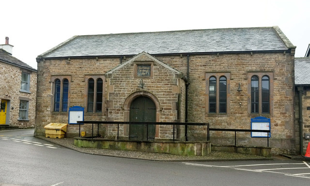
| Old School | 1383998 | II | 1845 | Now Dent Memorial Hall |
| Oliver Bridge | 1383974 | II | ||
| Packsaddle Bridge Beside Dent Head Viaduct | 1383848 | II | C18th | Old stone packhorse bridge |
| Pair of Interlinked Barns Approximately 5 Metres South East of Gap Farmhouse | 1383868 | II | ||
| Passenger Waiting Room on East Side of Railway Track at Dent Station | 1383850 | II | ||
| Peggles Wright Farmhouse and Cart Shed Attached at North End | 1383925 | II | ||
| Peggleside and Attached Barn | 1383927 | II | ||
| Platt | 1383811 | II | ||
| Post Office and Adjoining Barn | 1383984 | II | ||
| Rash Bridge | 1383928 | II | C18th | |
| Rash House | 1383929 | II | ||
| Rash Mill | 1383931 | II | ||
| Rash Mill Cottage and Attached Barn to East | 1383932 | II | ||
| Raw Ridding Farmhouse and Attached Barn | 1383933 | II | ||
| Roantree | 1383934 | II | ||
| Scar View (Old Portion to North Only) | 1383975 | II | ||
| Scotchergill Farmhouse | 1383935 | II | ||
| Sedgwick Cottage | 1383985 | II | ||
| Sedgwick Fountain | 1383986 | II | C19th | Dent. Memorial to geologist Adam Sedgwick |
| Siege Ghyll | 1383987 | II | ||
| Silverdale Cottage with Attached Barn | 1383937 | II | ||
| Slack Farmhouse | 1383812 | II | ||
| Spice Gill Farmhouse | 1383938 | II | ||
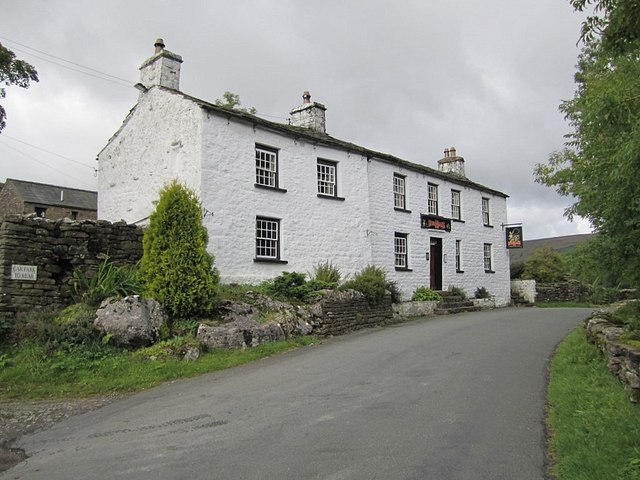
| Sportsmans Inn | 1383940 | II | C17th | Public House, Cow Dub |
| Stable Approximately 10 Metres North of East Banks Farmhouse | 1383855 | II | ||
| Stable Range Immediately West of Hacker Gill Farmhouse | 1383880 | II | ||
| Stable with Attached Privy to West of Hewthwaite Farmhouse | 1383890 | II | ||
| Stables and Loose Boxes Approximately 2 Metres South of Dairy Cottage | 1383844 | II | ||
| Stone Close Cafe and Adjoining Barn to West | 1383988 | II | ||
| Stonehouse | 1383941 | II | ||
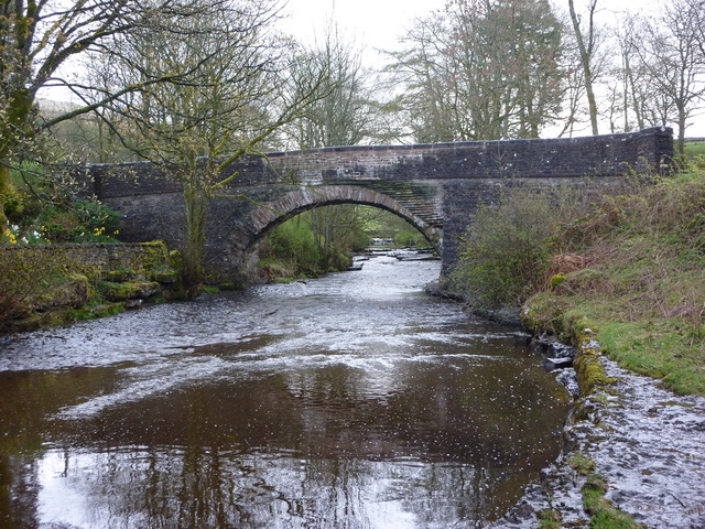
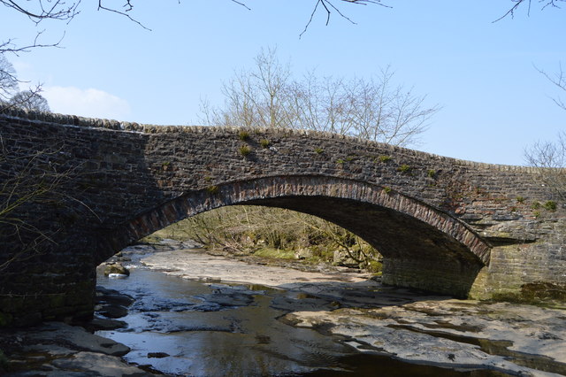
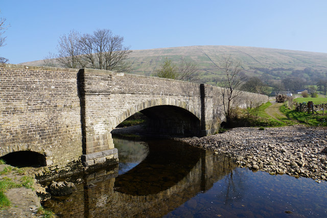
| Stonehouse Bridge | 1383942 | II | C17th | Road bridge over River Dee. |
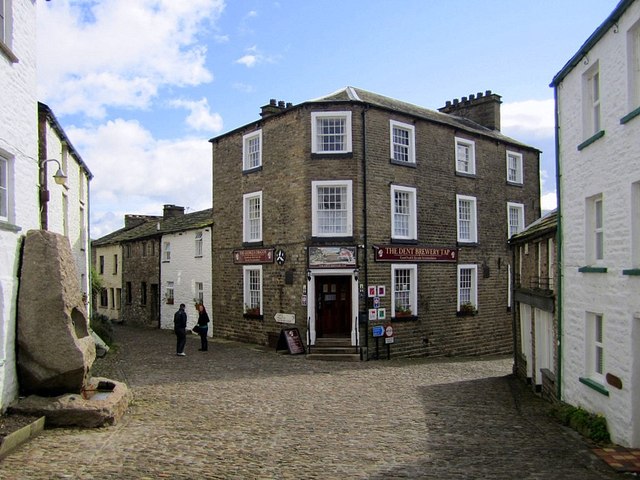
| Sun Inn | 1383989 | II | C18th | Dent village |
| Sundial Cottage | 1383944 | II | ||
| Sundial in Forecourt of Gate | 1383871 | II | ||
| The George and Dragon | 1383990 | II | C19th | Dent village |
| The Old Cobblers Shop and 2 Adjoining Cottages | 1383991 | II | ||
| The Old Station at Dent Railway Station | 1383851 | II | ||
| The Old Vicarage and the Old Parsonage | 1384000 | II | ||
| The Wool Shop | 1383992 | II | ||
| Three Roods with Former Shop and Barn Attached to East and Stable to North | 1383945 | II | ||
| Tofts Farmhouse | 1383946 | II | ||
| Tub Hole | 1383947 | II | ||
| Underwood | 1383976 | II | ||
| Washhouse Approximately 2 Metres North of Burton Hilll Farmhouse | 1383831 | II | ||
| Wesleyan Chapel | 1383999 | II | ||
| West Clint Farmhouse and Attached Barn | 1383948 | II | ||
| West Cowgill Farmhouse | 1383949 | II | ||
| West House Farmhouse at Whernside Manor Farm | 1383954 | II | ||
| West Stonehouse Farmhouse and Attached Garden Wall | 1383950 | II | ||
| West View and Cobble Cottage | 1383993 | II | ||
| Whernside Manor | 1383952 | II | ||
| White Hart House and Gable Cottage and Attached Mounting Steps | 1383994 | II | ||
| Womans Land | 1383955 | II | ||
| Woods | 1383813 | II | ||
| Workshop and Store Approximately 5 Metres South West of Spice Gill Farmhouse | 1383939 | II | ||
| Zion Chapel | 1383960 | II | ||
| Dent Head viaduct | 1007243 | n/a | Scheduled Monument | |
| Arten Gill viaduct | 1007242 | n/a | Scheduled Monument | |
| Dent Conservation Area | - | n/a | Conservation Area |
Primary source: the National Heritage List for England - NHLE is the register of nationally protected historic buildings and sites in England, including listed buildings, scheduled monuments, protected wrecks, registered parks and gardens, and battlefields. The list is maintained by Historic England. Check NHLE for updates and new entries. Secondary sources: British Listed Buildings.
Co-Curate Page
Church of St Andrew, Dent, South Lakeland
- Overview About St Andrew's Church Map Street View Inside St Andrew's Church in Dent, Cumbria, dates from around the 12th century. The parish church was enlarged and remodelled in the …
Co-Curate Page
War Memorial, Dent
- Overview Map Street View The war memorial in Dent is located at the south of St Andrew's Church. The memorial, in the form of a wheel cross, was built to commemorate …
Co-Curate Page
Stonehouse Bridge, Dentdale
- Overview Map Street View Stonehouse Bridge is a road bridge over the River Dee at Stone House in Dentdale, Cumbria. The stone segmental arched bridge is thought to date from …
Co-Curate Page
Sportsmans Inn, Upper Dentdale
- Overview Map Street View The Sportsmans Inn is a public House situated by the River Dee at Cow Dub, near Stone House in Upper Dentdale. It is a former farmhouse, …
Co-Curate Page
Artengill Viaduct
- Overview Map Street View Artengill Viaduct (aka Arten Gill Viaduct) carries the Settle and Carisle Railway line over the valley of Artengill Beck (stream). It is located to the north …
Co-Curate Page
Dent Memorial Hall
- Overview Map Street View Dent Memorial Hall is adjacent to Dent CofE Primary School. The hall is a former National School, which was built in 1845. It is Grade II …
Co-Curate Page
Dent Head Viaduct
- Overview Map Street View Dent Head Viaduct carryies the Settle to Carlisle Railway line over Fell End Gill. It was built c.1869-1875, for the Midland Railway Company, Chief Engineer John …
Co-Curate Page
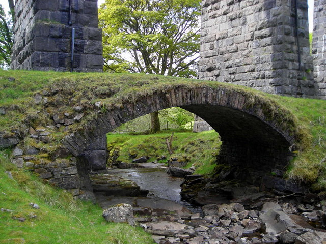
Packsaddle Bridge beside Dent Head Viaduct
- Packsaddle Bridge is an 18th century packhorse bridge over Fell End Gil. It stands next to, and is dwarfed by, the late 19th century Dent Head Viaduct. Packsaddle Bridge is …
Co-Curate Page
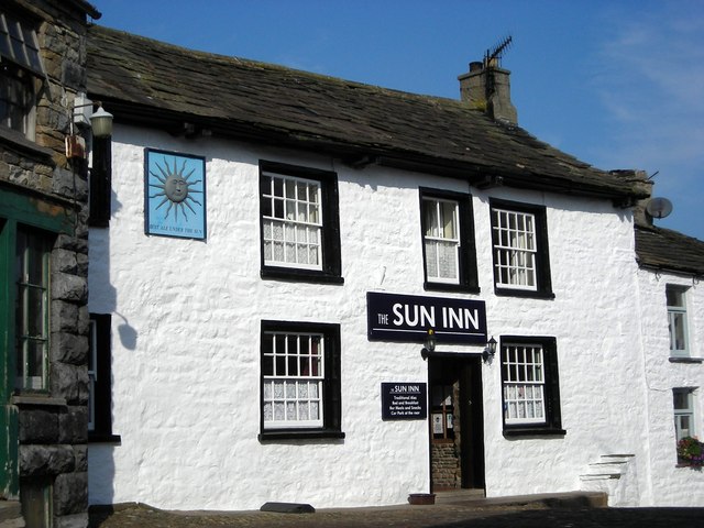
Sun Inn, Dent
- Overview Map Street View The Sun Inn is located on Main street in Dent. Originally an 18th century inn, it is said to have been "newly erected" in 1758, with …
Co-Curate Page
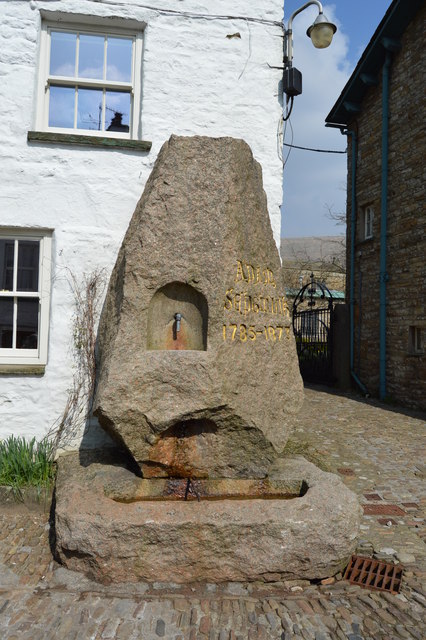
Adam Sedgwick Fountain, Dent
- Overview Map Street View This granite memorial fountain is in a prominent position on Main Street in Dent. It was erected in the late 19th century to commemorates Adam Sedgwick …
Co-Curate Page
Cowgill Bridge
- Overview Map Street View This road bridge crosses Cowgill Beck, shortly before the becks confluence with the River Dee. It is located near St John's Church in Cowgill. The bridge …
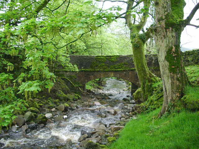
Co-Curate Page
Dockra Bridge
- Overview Map Dockra Bridge is a road bridge over Cowgill Beck, located on the north side of Cowgill, along Dockra Lane. It was built in the late 18th century to …
Co-Curate Page
The George and Dragon, Dent
- Overview Map Street View The George and Dragon is a public house, restaurant, with accommodation, located on Main Street in Dent. The George and Dragon was rebuilt in the 19th …
Co-Curate Page
Rash Bridge
- Overview Map Street View Rash Bridge carries the road over the River Dee on Mill Lane, near Rash in Cumbria. The coursed rubble bridge was probably built in the 18th …
Co-Curate Page
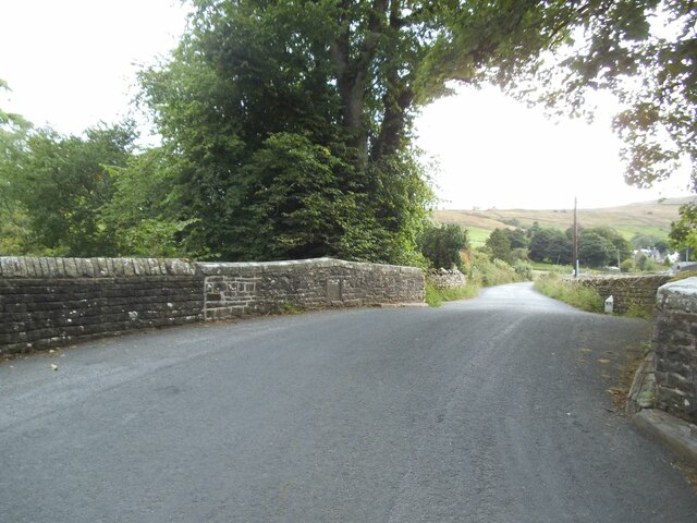
Church Bridge, Dent
- Overview Map Street View Church Bridge carries Beach Hill (road) over the River Dee in Dent, Cumbria. It is located a short distance north east of St Andrew's Church and …

Co-Curate Page
Church of St Andrew, Dent, South Lakeland
- Overview About St Andrew's Church Map Street View Inside St Andrew's Church in Dent, Cumbria, dates from around the 12th century. The parish church was enlarged and remodelled in the …
Co-Curate Page
War Memorial, Dent
- Overview Map Street View The war memorial in Dent is located at the south of St Andrew's Church. The memorial, in the form of a wheel cross, was built to commemorate …
Co-Curate Page
Stonehouse Bridge, Dentdale
- Overview Map Street View Stonehouse Bridge is a road bridge over the River Dee at Stone House in Dentdale, Cumbria. The stone segmental arched bridge is thought to date from …
Co-Curate Page
Sportsmans Inn, Upper Dentdale
- Overview Map Street View The Sportsmans Inn is a public House situated by the River Dee at Cow Dub, near Stone House in Upper Dentdale. It is a former farmhouse, …
Co-Curate Page
Artengill Viaduct
- Overview Map Street View Artengill Viaduct (aka Arten Gill Viaduct) carries the Settle and Carisle Railway line over the valley of Artengill Beck (stream). It is located to the north …
Co-Curate Page
Dent Memorial Hall
- Overview Map Street View Dent Memorial Hall is adjacent to Dent CofE Primary School. The hall is a former National School, which was built in 1845. It is Grade II …
Co-Curate Page
Dent Head Viaduct
- Overview Map Street View Dent Head Viaduct carryies the Settle to Carlisle Railway line over Fell End Gill. It was built c.1869-1875, for the Midland Railway Company, Chief Engineer John …
Co-Curate Page
Packsaddle Bridge beside Dent Head Viaduct
- Packsaddle Bridge is an 18th century packhorse bridge over Fell End Gil. It stands next to, and is dwarfed by, the late 19th century Dent Head Viaduct. Packsaddle Bridge is …
Co-Curate Page
Sun Inn, Dent
- Overview Map Street View The Sun Inn is located on Main street in Dent. Originally an 18th century inn, it is said to have been "newly erected" in 1758, with …
Co-Curate Page
Adam Sedgwick Fountain, Dent
- Overview Map Street View This granite memorial fountain is in a prominent position on Main Street in Dent. It was erected in the late 19th century to commemorates Adam Sedgwick …
Co-Curate Page
Cowgill Bridge
- Overview Map Street View This road bridge crosses Cowgill Beck, shortly before the becks confluence with the River Dee. It is located near St John's Church in Cowgill. The bridge …
Co-Curate Page
Dockra Bridge
- Overview Map Dockra Bridge is a road bridge over Cowgill Beck, located on the north side of Cowgill, along Dockra Lane. It was built in the late 18th century to …
Co-Curate Page
The George and Dragon, Dent
- Overview Map Street View The George and Dragon is a public house, restaurant, with accommodation, located on Main Street in Dent. The George and Dragon was rebuilt in the 19th …
Co-Curate Page
Rash Bridge
- Overview Map Street View Rash Bridge carries the road over the River Dee on Mill Lane, near Rash in Cumbria. The coursed rubble bridge was probably built in the 18th …


