Topics > County Durham > Civil Parishes in County Durham > Cotherstone Civil Parish > Historic Buildings and Monuments in Cotherstone Civil Parish
Historic Buildings and Monuments in Cotherstone Civil Parish
Listed buildings and scheduled monuments in Cotherstone Civil Parish, County Durham, from the National Heritage List for England and Locally Valued Heritage Assets from Cotherstone Parish Neighbourhood Plan (draft October 2020). Use the Search (below) if looking for a specific building / monument.
| Structure | List No. | Grade | Built~ | Note |
|---|---|---|---|---|
| Balder Bridge | 1121041 | II* | C15th | Widened 1896. Partly in Hunderthwaite CP. |
| Barn Attached to Rear of Clove Lodge Farmbuildings Attached to West of Barn | 1159876 | II | ||
| Brook House | 1159951 | II | ||
| Brook Lea House (Shown on Os Map As Brook House) | 1323053 | II | ||
| Butter Stone | 1121050 | II | c.1663 | Near Lartington. |
| Clove Lodge Farmhouse, Byre/Stables Attached to West and Range of Sheds Attached to East | 1121042 | II | ||
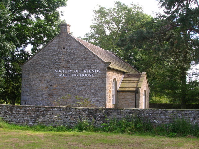
| Cotherstone Friends Meeting House | 1323052 | II | 1796 | Quaker Meeting House |
| Elwy Cottage and Laburnum Cottage and Branton Cottage and Garden Walls | 1121045 | II | ||
| Fox Hall | 1121048 | II | ||
| Gilmour House, Former Byre and Barn | 1121049 | II | ||
| Hallgarth Hill House | 1121046 | II | ||
| Hury Mill Bridge | 1323081 | II | ||
| Link and Stable/Byre Attached to Trees Farmhouse | 1121044 | II | ||
| Linked Farmbuildings, 20 Metres North of Pecknell Farmhouse | 1159992 | II | ||
| Lodge, Gate Piers and Gate, 110 Metres East of Lancelands | 1160106 | II | ||
| Mere Beck Farmhouse, Byre and Pigsty | 1323051 | II | ||
| Pecknell Farmhouse | 1323054 | II | ||
| Red Lion Inn and Red Lion Cottage | 1310718 | II | ||
| Saltoun House | 1323055 | II | ||
| Summerhouse and Attached Garden Wall, 30 Metres North East of Hagg House | 1121047 | II | ||
| The Green and Front Garden Wall | 1310796 | II | ||
| The Manor House | 1159936 | II | ||
| Towler Hill Farmhouse | 1159976 | II | ||
| Trees Farmhouse | 1310829 | II | ||
| Weatherby House and Wall and Doorway to Right | 1160008 | II | ||
| West Park Farmhouse | 1159890 | II | ||
| Woodvine Cottages | 1160071 | II | ||
| Cup and ring marked rock on Cotherstone Moor 520m north west of East Loups's | 1018323 | n/a | Scheduled Monument | |
| Three prehistoric carved rocks on Goldsborough Rigg, Cotherstone Moor, 860m SSE Pitcher House | 1016598 | n/a | Scheduled Monument | |
| Ring cairn on Goldsborough, Cotherstone Moor, 840m south of Pitcher House | 1019155 | n/a | Scheduled Monument | |
| Cup and groove marked rock on Goldsborough Rigg, Cotherstone Moor, 920m south east of Pitcher House | 1016600 | n/a | Scheduled Monument | |
| Rock with one cup on Goldsborough Rigg, Cotherstone Moor, 860m north west of West Loups's | 1016604 | n/a | Scheduled Monument | |
| Cup and ring marked rock on Goldsborough Rigg, Cotherstone Moor, 870m south south east of Pitcher House | 1016599 | n/a | Scheduled Monument | |
| Cup ring and groove marked rock outcrop at Toby Wall, 260m north east of West Loups's, Cotherstone Moor | 1018322 | n/a | Scheduled Monument | |
| Rock with many cup marks on the east bank of How Beck, 450m north west of West Loups's, Cotherstone Moor | 1016597 | n/a | Scheduled Monument | |
| Cotherstone Castle | 1005583 | n/a | Scheduled Monument | |
| Cup marked rock 100m north of West Loups's, Cotherstone Moor | 1018326 | n/a | Scheduled Monument | |
| Cup and ring marked rock 80m south of West Loups's, Cotherstone Moor | 1018321 | n/a | Scheduled Monument | |
| Cup, ring and groove marked rock 310m west of East Loups's, Cotherstone Moor | 1018324 | n/a | Scheduled Monument | |
| Cup and ring marked rock on Goldsborough Rigg, Cotherstone Moor, 860m south east of Pitcher House | 1017199 | n/a | Scheduled Monument | |
| Cup marked rock outcrop at the base of a wall 120m east of East Loups's, Cotherstone Moor | 1018325 | n/a | Scheduled Monument | |
| Medieval farmstead and two prehistoric carved rocks at West Loup's | 1016601 | n/a | Scheduled Monument | |
| Medieval farmstead 330m north west of Water Knott | 1021093 | n/a | Scheduled Monument | |
| Back lanes | LVHA1 | Local | Medieval field system | |
| West Green | LVHA2 | Local | ||
| East Green | LVHA3 | Local | ||
| Estate boundary marker post (Duke of Devonshire) | LVHA4 | Local | ||
| 3 West Cottages | LVHA5 | Local | With notable gable ventilation slots | |
| Traditional Cotherstone village entry sign | LVHA6 | Local | C20th | Cast iron sign at south of village |
| Ashfield | LVHA7 | Local | Former church parochial school | |
| Cotherstone Village Hall | LVHA8 | Local | 1893 | Former Temperance Hall |
| Chapel Villa | LVHA9 | Local | Former congregational church | |
| 3 Nicholson Terrace | LVHA10 | Local | Incorporating date stones | |
| Berriman Barn | LVHA11 | Local | Incorporating stone from Cotherstone Castle | |
| Abraham Hilton Grave | LVHA12 | Local | ||
| Traditional road sign - Briscoe Lane | LVHA13 | Local | ||
| Tees Railway Path | LVHA14 | Local | Former railway line and bridges | |
| East Briscoe road bridge | LVHA15 | Local | ||
| Osmond Bridge, North Corn Park | LVHA16 | Local |
Primary sources: the National Heritage List for England - NHLE is the register of nationally protected historic buildings and sites in England, including listed buildings, scheduled monuments, protected wrecks, registered parks and gardens, and battlefields. The list is maintained by Historic England. Check NHLE for updates and new entries. Cotherstone Parish Neighbourhood Plan 2020-2035 (pre-submission draft, October 2020) from Cotherstone Parish Council.
Secondary sources: British Listed Buildings and Keys to the Past.
Co-Curate Page
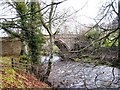
Balder Bridge, Cotherstone
- Overview Map Street View The stone road bridge over the River Balder at Cotherstone dates back to the 15th century. It was rebuilt c.1681 and the upstream side of the …
Co-Curate Page
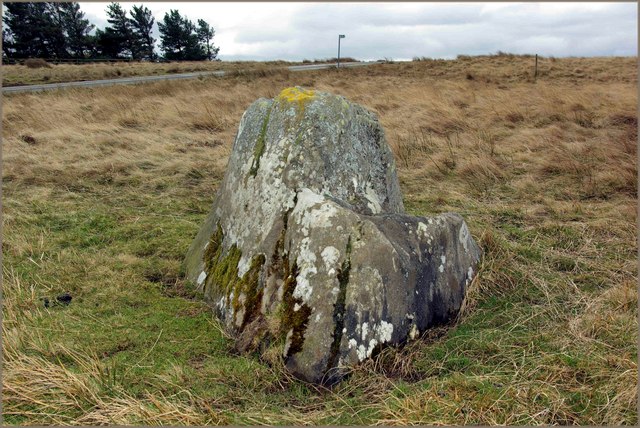
Butter Stone, nr Lartington
- Overview Map Street View Butter Stone is a prominent boulder located on the moors near Lartington and Cotherstone. It was used during the 1663-5 plague as a place where villagers …
Co-Curate Page
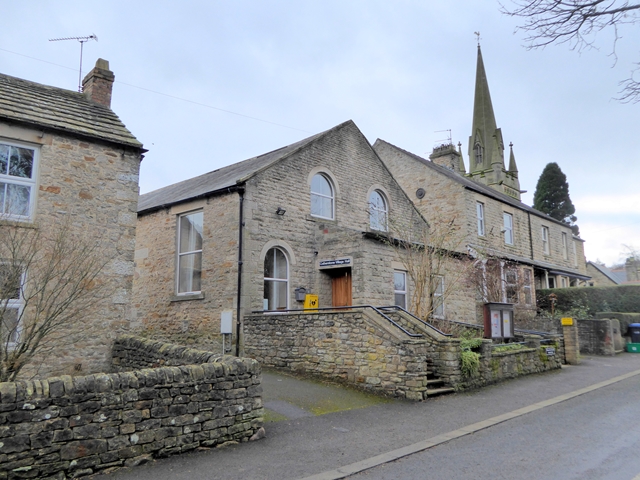
Village Hall, Cotherstone
- Overview Map Street View The village hall in Cotherstone was originally built in 1893 as a Temperance Hall. It has been modernised for it's use as a village hall and …
Co-Curate Page
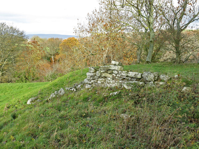
Cotherstone Castle (remains)
- There are a few earthwork remains of the castle at Cotherstone. This was originally a Norman motte and bailey castle of c.1090. A Royal licence to crenellate (fortify) was granted on the …
Co-Curate Page
Friends' Meeting House, Cotherstone
- Overview Map The Friends' Meeting House at Cotherstone is located in a field to the east of the village. The meeting house was built in 1797 and is still an …

Co-Curate Page
Balder Bridge, Cotherstone
- Overview Map Street View The stone road bridge over the River Balder at Cotherstone dates back to the 15th century. It was rebuilt c.1681 and the upstream side of the …
Co-Curate Page
Butter Stone, nr Lartington
- Overview Map Street View Butter Stone is a prominent boulder located on the moors near Lartington and Cotherstone. It was used during the 1663-5 plague as a place where villagers …
Co-Curate Page
Village Hall, Cotherstone
- Overview Map Street View The village hall in Cotherstone was originally built in 1893 as a Temperance Hall. It has been modernised for it's use as a village hall and …
Co-Curate Page
Cotherstone Castle (remains)
- There are a few earthwork remains of the castle at Cotherstone. This was originally a Norman motte and bailey castle of c.1090. A Royal licence to crenellate (fortify) was granted on the …


