Topics > Civil Parishes in Cumbria > Casterton Civil Parish > Historic Buildings and Monuments in Casterton Civil Parish
Historic Buildings and Monuments in Casterton Civil Parish
Listed buildings and scheduled monuments in Casterton Civil Parish, Cumbria, from the National Heritage List for England[1]. In the absence of a published 'local list', some other public buildings of interest are also be included. Use the Search (below) if looking for a specific building / monument.
| Structure | List No. | Grade | Built~ | Note |
|---|---|---|---|---|
| 2 Limekilns Approximately 220m South of Bullpot Farm | 1086901 | II | C18th | Casterton Fell |
| 2 Limekilns South of Little Aygill at Sd 662 818 | 1137562 | II | C18th | |
| Barn to West of Bee Nest Farmhouse | 1086902 | II | C18th | |
| Bee Nest Farmhouse | 1137567 | II | 1723 | |
| Bellgate Farmhouse | 1086898 | II | C18th | |
| Casterton Hall, East Wing, the Mews (Includes the Orangery) | 1335933 | II* | C19th | Country house, now 3 residences. |
| Casterton Old Hall | 1086900 | II | C17th | |
| Church of Holy Trinity | 1335935 | II | 1833 | |
| Cow Shelter Approximately 110m South of High Lodge | 1086897 | II | C19th | |
| Devils Bridge | 1086899 | I | C15/C16th | Over River Lune. Partly in this parish. |
| Gatehouse | 1086895 | II | C18th | Former toll house |
| Kirfitt Hall and Attached Outbuilding | 1086935 | II | C17th | Farmhouse |
| Limekiln at SD 621 797 | 1335936 | II | C18th | |
| Limekiln at SD 628 799 | 1137462 | II | C18th | |
| Lodge to Whelprigg | 1335911 | II | 1860 | |
| Milestone by the Grange | 1086896 | II | C19th | Sedbergh Turnpike Trust |
| Old Manor | 1137576 | II | C19th | Older C17th parts. High Casterton |
| Railway Underbridge to West Lodge to Whelprigg | 1137472 | II | C19th | |
| Sculptured cross near Shamrock Wood, Whelprigg | 1007168 | n/a | Medieval | Scheduled Monument |
| Stone circle 200yds (180m) SE of Langthwaite Gill Plantation | 1007245 | n/a | Bronze Age? | Scheduled Monument |
| Devil's Bridge | 1007209 | n/a | C15th/C16th | Scheduled Monument. Partly in this parish. |
| Prehistoric, Romano-British, medieval and early post-medieval settlements, field systems and a deer park at High Park, east of Bindloss Farm | 1019016 | n/a | Prehistoric | Scheduled Monument |
| The Grange | not listed | n/a | 1848 | Casterton |
| The Pheasant Inn | not listed | n/a | C18th? | Casterton |
Primary source: the National Heritage List for England - NHLE is the register of nationally protected historic buildings and sites in England, including listed buildings, scheduled monuments, protected wrecks, registered parks and gardens, and battlefields. The list is maintained by Historic England. Check NHLE for updates and new entries. Secondary sources: British Listed Buildings.
Co-Curate Page
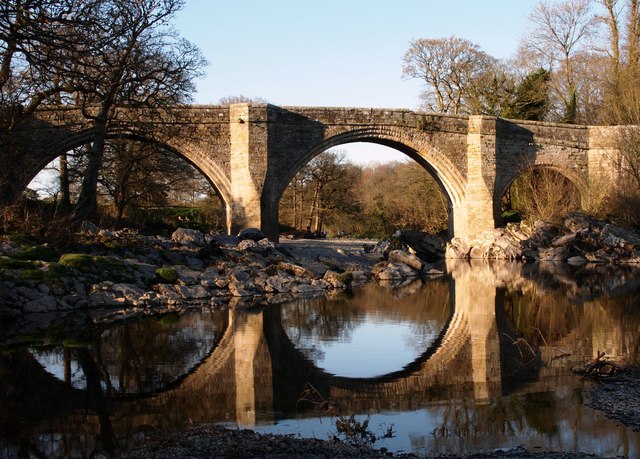
Devil's Bridge
- Overview Map Street View Devil's Bridge crosses the River Lune to the south-east of the town of Kirkby Lonsdale. The bridge straddles the civil parishes of Kirkby Lonsdale and Casterton. …
Co-Curate Page
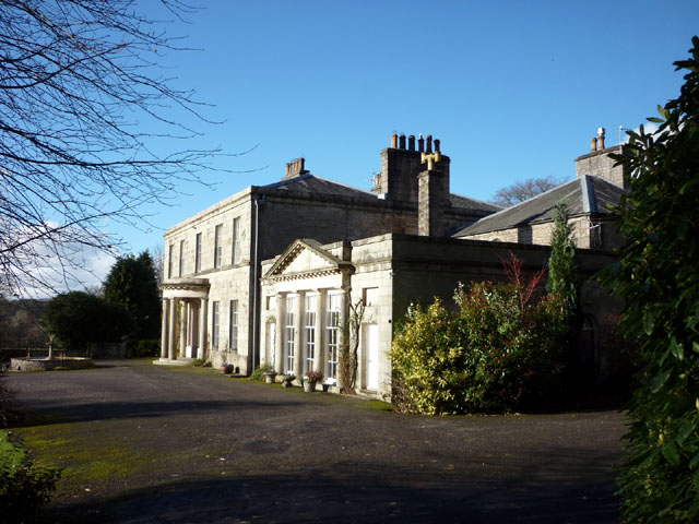
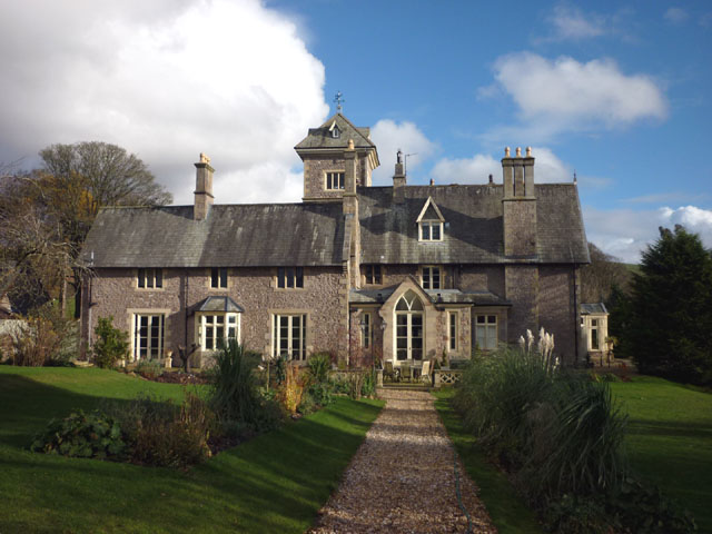
Casterton Hall
- Overview Map Street View Casterton Hall is located in woodland by the River Lune at the south-west of Casterton. It is a neo-classical style country house built in 1811, thought …
Co-Curate Page
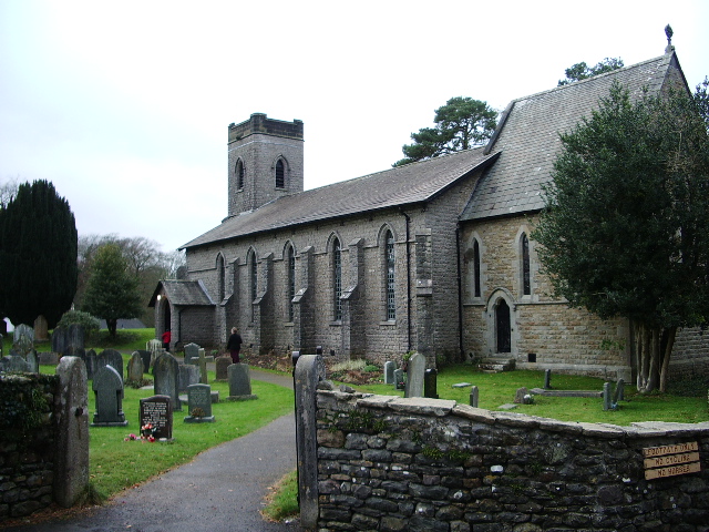
Church of Holy Trinity, Casterton
- Overview Map Street View Holy Trinity Church at Casterton was built 1831-1833, it's chancel was added in c1860, by Crowther. Some of it's stained glass was by stained glass by …
Co-Curate Page
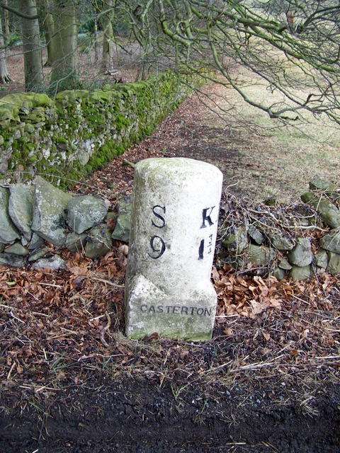
Old Milestone, by Casterton Grange
- Overview Map Street View This old stone milestone is located on the west side of the A683 close to the entrance to Casterton Grange, to the north of the village of …
Co-Curate Page
Casterton Stone Circle
- Overview Map An embanked circle of 17 relatively small stones, probably dating from the Bronze Age. The stone circle is located near Langthwaite Gill Plantation and about 1 mile east …
Co-Curate Page
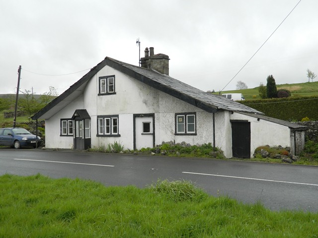
Toll Bar Cottage, Casterton
- Overview Map Street View This former toll house is located on the A683 road, near the entrance to Casterton Golf Course, to the south-west of the village of Casterton. It …
Co-Curate Page
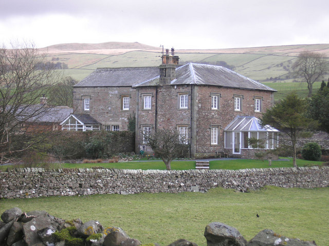
Old Manor, High Casterton
- Overview Map Street View The Old Manor in High Casterton is the former manor house. The current building was largely rebuilt in the 19th century, but retains it's 17th century …
Co-Curate Page
Casterton Grange
- Overview Map 'The Grange' is a large house, set back of the A638 road, a short distance north of Casterton. It was built in 1848 on lands owned by the …
Co-Curate Page
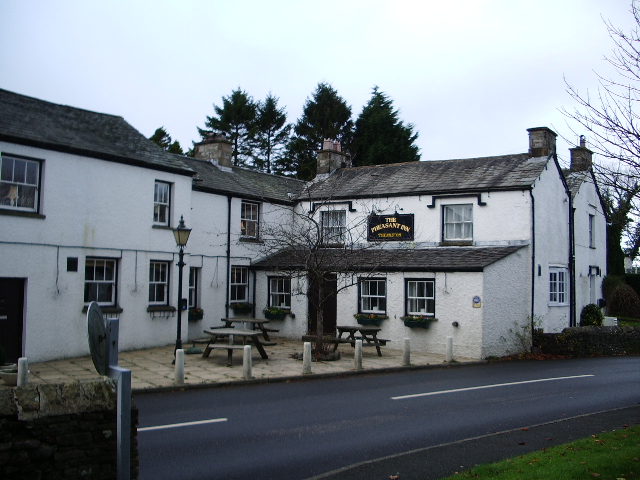
The Pheasant Inn, Casterton
- Overview Map Street View The Pheasant Inn is a public house and resturant in Casterton. It is a former coaching inn, previously known as The George and Dragon. It is …
Co-Curate Page
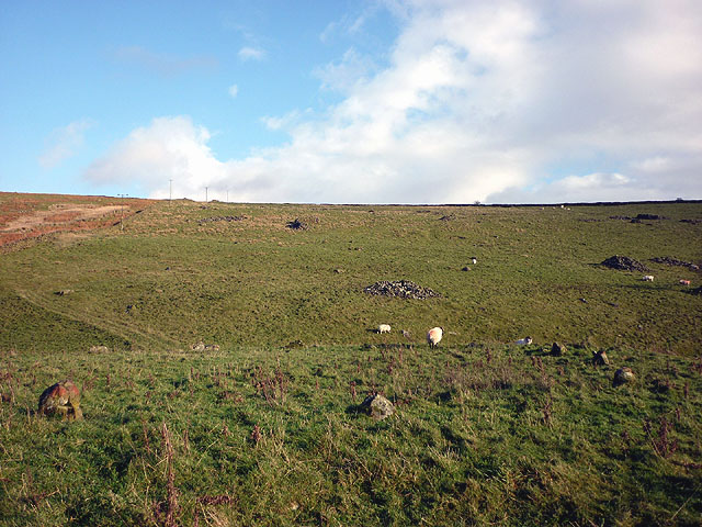
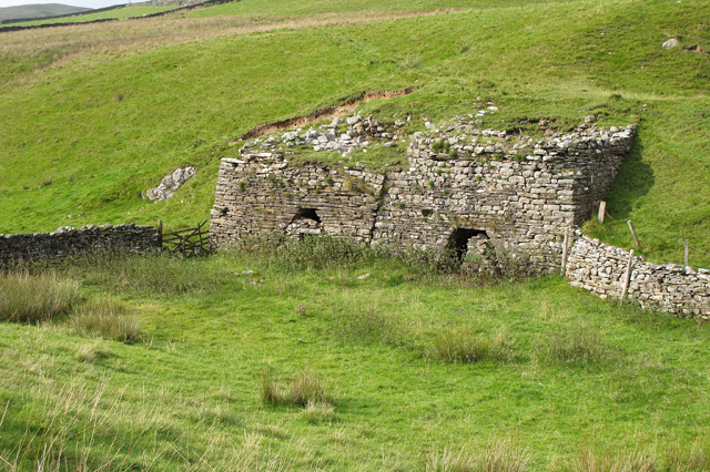
Limekilns south of Bullpot Farm, Casterton
- There are two old stone rubble limekilns, located 220m south of Bullpot Farm on Casterton Fell. The limekilns are thought to date from the 18th century. The limekilns are Grade …
Co-Curate Page
Kirfitt Hall Farm
- Overview Map Kirfitt Hall Farm is located near the east bank of the River Lune, about half mile north-east of Kirkby Lonsdale and half mile south-west of Casterton. The farmhouse …

Co-Curate Page
Devil's Bridge
- Overview Map Street View Devil's Bridge crosses the River Lune to the south-east of the town of Kirkby Lonsdale. The bridge straddles the civil parishes of Kirkby Lonsdale and Casterton. …
Co-Curate Page
Casterton Hall
- Overview Map Street View Casterton Hall is located in woodland by the River Lune at the south-west of Casterton. It is a neo-classical style country house built in 1811, thought …
Co-Curate Page
Church of Holy Trinity, Casterton
- Overview Map Street View Holy Trinity Church at Casterton was built 1831-1833, it's chancel was added in c1860, by Crowther. Some of it's stained glass was by stained glass by …
Co-Curate Page
Old Milestone, by Casterton Grange
- Overview Map Street View This old stone milestone is located on the west side of the A683 close to the entrance to Casterton Grange, to the north of the village of …
Co-Curate Page
Casterton Stone Circle
- Overview Map An embanked circle of 17 relatively small stones, probably dating from the Bronze Age. The stone circle is located near Langthwaite Gill Plantation and about 1 mile east …
Co-Curate Page
Toll Bar Cottage, Casterton
- Overview Map Street View This former toll house is located on the A683 road, near the entrance to Casterton Golf Course, to the south-west of the village of Casterton. It …
Co-Curate Page
Old Manor, High Casterton
- Overview Map Street View The Old Manor in High Casterton is the former manor house. The current building was largely rebuilt in the 19th century, but retains it's 17th century …
Co-Curate Page
Casterton Grange
- Overview Map 'The Grange' is a large house, set back of the A638 road, a short distance north of Casterton. It was built in 1848 on lands owned by the …
Co-Curate Page
The Pheasant Inn, Casterton
- Overview Map Street View The Pheasant Inn is a public house and resturant in Casterton. It is a former coaching inn, previously known as The George and Dragon. It is …
Co-Curate Page
Limekilns south of Bullpot Farm, Casterton
- There are two old stone rubble limekilns, located 220m south of Bullpot Farm on Casterton Fell. The limekilns are thought to date from the 18th century. The limekilns are Grade …


