Topics > Civil Parishes in Cumbria > Burgh by Sands Civil Parish > Historic Buildings and Monuments in Burgh by Sands Civil Parish
Historic Buildings and Monuments in Burgh by Sands Civil Parish
Listed buildings and scheduled monuments in Burgh by Sands Civil Parish, Cumbria, from the National Heritage List for England[1]. In the absence of a published 'local list', some other public buildings of interest may also be included. Use the Search (below) if looking for a specific building / monument.
| Structure | List No. | Grade | Built~ | Notes |
|---|---|---|---|---|
| Barn Adjoining to North of Moorhouse Farmhouse | 1335655 | II* | C17th | |
| Barn and Byres South East of House Occupied by Mrs Wallace | 1087460 | II | C19th | |
| Barn to the West of Stonehouse | 1247869 | II | C18th | |
| Boundary Wall North of Friends' Meeting House | 1087462 | II | C18th | Moorhouse |
| Boustead Hill Bridge | 1087488 | II | c.1823 | Boustead Hill |
| Boustead Hill House | 1052311 | II | C19th | Boustead Hill |
| Brewery Cottage | 1335653 | II | C18th | Longburgh |
| Brewery Farm | 1335654 | II | C17th | |
| Buck Bottom and Adjoining Barn | 1087492 | II | C17th | |
| Burgh by Sands War Memorial | 1441498 | II | 1921 | |
| Burgh Head House | 1087493 | II | C19th | |
| Burgh House | 1335633 | II | ||
| Burial Ground Wall North of the Friend's Meeting House | 1040006 | II | 1694 | Moorhouse |
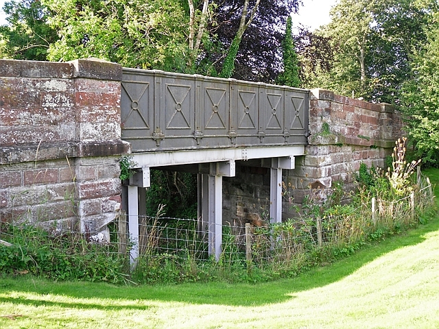
| Canal Aqueduct | 1335635 | II | c.1823 | near Boustead Hill |
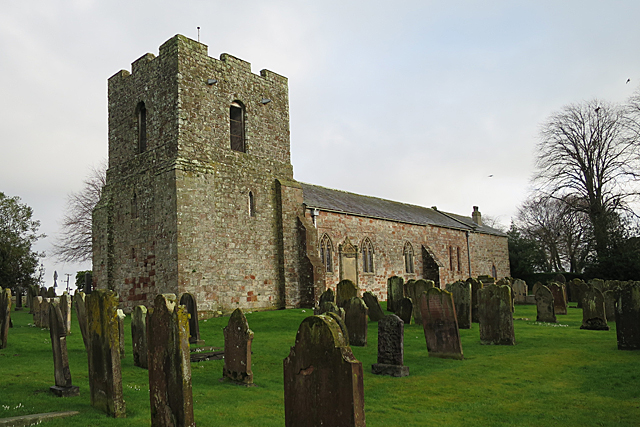
| Church of St Michael | 1367134 | I | C12th | Burgh By Sands. Bell tower added 1360 |
| Croft House and Stables | 1087487 | II | ||
| Cross Farm and Adjoining Barns | 1054698 | II | ||
| Cruck Cottage at Entrance to Moorhouse Farm | 1087459 | II | ||
| Dykesfield | 1087497 | II | 1748 | House, Dykesfield |
| Dykesfield Bridge | 1054043 | II | c.1823 | Dykesfield |
| Fairfield | 1040026 | II | ||
| Farmhouse Occupied by Mrs Wallace (Opposite Stonehouse) | 1335656 | II | ||
| Fauld Farm and Adjoining Outbuilding | 1039913 | II | ||
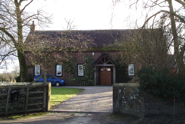
| Former Friends' Meeting House | 1372045 | II | 1733 | Moorhouse |
| Garden Wall South of Burgh House and Fulwood House | 1372093 | II | ||
| Garden Wall to North East of Longburgh Hall | 1335652 | II | ||
| Hall Farm | 1087461 | II | C17th | Moorhouse |
| Highfield | 1335632 | II | ||
| Hillside Farmhouse | 1052256 | II | ||
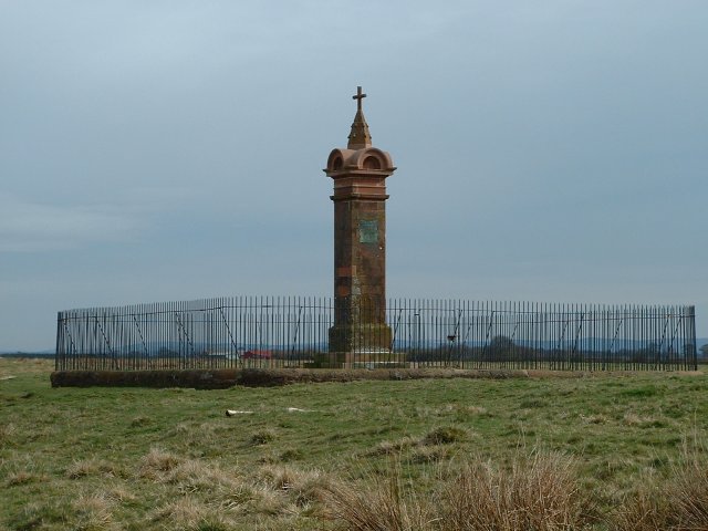
| King Edward I Monument | 1087463 | II* | 1685 | Rebuilt 1803 |
| Kokied Cottage | 1045905 | II | ||
| Lamonby Farmhouse and Adjoining Barn | 1039874 | II* | C17th | |
| Leigh Cottage | 1259563 | II | ||
| Longburgh Farm and Adjoining Barn (Not to Be Confused with Longburgh Farmhouse to East) | 1087456 | II | Longburgh | |
| Longburgh Farmhouse (Not to Be Confused with Longburgh Farm to West) | 1087457 | II | Longburgh | |
| Longburgh House and Adjoining Outbuildings | 1087454 | II | Longburgh | |
| Low Moorhouse | 1335657 | II | ||
| Midtown Farmhouse | 1039864 | II | ||
| Moorhouse Farmhouse and Stables | 1087458 | II | ||
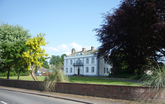
| Moorhouse Hall | 1040055 | II | C18th | Moorhouse |
| North End Cottage | 1087495 | II | ||
| Orchard House | 1369996 | II | ||
| Rose Mount | 1087490 | II | ||
| Shepherds Hill Farmhouse | 1335659 | II | ||
| South View | 1087464 | II | ||
| Stonehouse and Adjoining Outbuilding | 1335658 | II | ||
| The Beeches and Adjoining Barn | 1045881 | II | ||
| The Greyhound Inn | 1087491 | II | C18th | Burgh By Sands |
| The Hill | 1054029 | II | ||
| The Hollies | 1087465 | II | ||
| The Old Vicarage | 1087494 | II | ||
| Tower to North West of Fulwood House | 1087489 | II | ||
| West End | 1087496 | II | ||
| West Green Bridge | 1335634 | II | c.1823 | Burgh By Sands |
| White Cottage | 1087455 | II | ||
| Wormanby Farmhouse | 1045884 | II | 1772 | Wormanby |
| Wormanby House | 1335660 | II | C18th | Wormanby |
| Yew Tree Cottage | 1054731 | II | ||
| Hadrian's Wall Vallum between West End, Burgh by Sands and the eastern boundary of Dykesfield | 1018308 | n/a | Roman | Scheduled Monument |
| Hadrian's Wall vallum between east side of road at Burgh Head, and boundary south of Ash Tree Square, Burgh-by-Sands in wall miles 71 and 72 | 1018458 | n/a | Roman | Scheduled Monument |
| Burgh by Sands Roman fort, Beaumont camp, Burgh Castle and Hadrian's Wall from boundary west of churchyard, Beaumont to Burgh Head in wall miles 70 and 71 | 1018457 | n/a | Roman | Scheduled Monument |
| Hadrian's Wall between Fulwood House at Burgh by Sands and Burgh Marsh in wall miles 72 and 73 | 1014698 | n/a | Roman | Scheduled Monument |
| Hadrian's Wall vallum between the dismantled railway west of Kirkandrews Farm and the dismantled railway south east of Burgh by Sands in wall miles 70 and 71 | 1014697 | n/a | Roman | Scheduled Monument |
| Roman fort and watch tower, 800m SSW of Amberfield | 1007067 | n/a | Roman | Scheduled Monument |
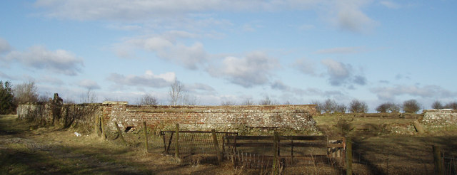
| Settlement and field system N of Moorhouse | 1007070 | n/a | Romano-British | Scheduled Monument |
| Settlement enclosures, 800m north west of Farhill | 1007081 | n/a | Romano-British | Scheduled Monument |
| The Royal Oak | not listed | n/a | C18th? | Moorhouse |
| Burgh by Sands Conservation Area | - | n/a | Conservation Area | |
| Longburgh Conservation Area | - | n/a | Conservation Area |
Primary source: the National Heritage List for England - NHLE is the register of nationally protected historic buildings and sites in England, including listed buildings, scheduled monuments, protected wrecks, registered parks and gardens, and battlefields. The list is maintained by Historic England. Check NHLE for updates and new entries. Secondary sources: British Listed Buildings.
Co-Curate Page
Church of St Michael, Burgh By Sands
- Extract from: Bygone Cumberland and Westmorland, by Daniel Scott, 1899. p.30. Section on "Fighting Bishops and Fortified Churches." "The tower of Burgh-by-Sands Church, close to the Solway, was built at …
Co-Curate Page
King Edward I Monument, Burgh by Sands
- The monument marks the place on Burgh Marsh, by the Solway Firth, where King Edward I of England died (age 68) on the 7th of July, 1307 after developing dysentery. …
Co-Curate Page
Moorhouse Hall
- Overview Map Street View Moorhouse Hall in Moorhouse, Burgh-by-Sands, was built in the mid 18th century. It was marked on Hodgskinson & Donald's map of Cumberland, surveyed 1770, as house …
Co-Curate Page
Friends Meeting House, Moorhouse
- Overview Map Street View A former Friends Meeting House (Quakers) is located in Moorhouse. The meeting house was built 1733, replacing an earlier meeting house of 1681. The Meeting closed in …
Co-Curate Page
Quaker Burial Ground, Moorhouse
- Overview Map Street View Moorhouse in Cumbria was an early meeting of the Religious Society of Friends (Quakers). A meeting house was built here in 1681 and a plot of …

Co-Curate Page
Canal Aqueduct, west of Boustead Hill
- Overview Map Street View This old red brick bridge, west of Boustead Hill by the Solway Firth, was originally an aqueduct for the Carlisle Canal, built 1819-1823. It has two …

Co-Curate Page
Wall Mile 70
- <Mile 69 | Mile 70 | Mile 71> Hadrian's Wall - Wall Mile 70 Hadrian's Wall stretches from the east to west coast of England and was an important frontier …

Co-Curate Page
Wall Mile 71
- <Mile 70 | Mile 71 | Mile 72> Hadrian's Wall - Wall Mile 71 Hadrian's Wall stretches from the east to west coast of England and was an important frontier …

Co-Curate Page
Wall Mile 72
- <Mile 71 | Mile 72 | Mile 73> Hadrian's Wall - Wall Mile 72 Hadrian's Wall stretches from the east to west coast of England and was an important frontier …

Co-Curate Page
Wall Mile 73
- <Mile 72 | Mile 73 | Mile 74> Hadrian's Wall - Wall Mile 73 Hadrian's Wall stretches from the east to west coast of England and was an important frontier …

Co-Curate Page
Wormanby Farm
- Overview Map Street View Wormanby Farm is located about ½mile south-east of Burgh by Sands. The farmhouse at Wormandy is dated 1772, with a further date of 1850 and inscription …

Co-Curate Page
Dykesfield House
- Dykesfield (house), in the hamlet of Dykesfield, near Burgh by Sands, dates from 1748 and is a Grade II listed building on the National Heritage List for England.

Co-Curate Page
Dykesfield Bridge
- Overview Map Street View The bridge in Dykesfield was originally built as a draw-bridge to carry the road to Longburgh over the Carlisle Canal, which was built 1819-1823. After the …

Co-Curate Page
Roman fort and watch tower, south of Burgh by Sands
- Overview Map The site of a Roman fort and watch tower are located just over ½mile south of Burgh by Sands (and the course of Hadrian's Wall, which ran through …

Co-Curate Page
Greyhounds Inn, Burgh by Sands
- Overview Map Street View The Greyhounds Inn is a public house in Burgh by Sands. It was originally a house built in the late 18th century. The pub was taken …

Co-Curate Page
Hall Farm, Moorhouse
- Overview Map Street View Hall Farm is located in Moorhouse. The farmhouse dates from the late 17th century, with 19th century alterations. It is a Grade II listed building on …
Co-Curate Page
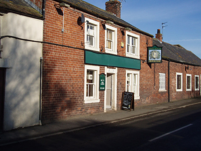
The Royal Oak, Moorhouse
- Overview Map Street View The Royal Oak is a public house in Moorhouse, situated on the B5307 road. The pub was taken over by the State Management Scheme in c.1916 …

Co-Curate Page
Church of St Michael, Burgh By Sands
- Extract from: Bygone Cumberland and Westmorland, by Daniel Scott, 1899. p.30. Section on "Fighting Bishops and Fortified Churches." "The tower of Burgh-by-Sands Church, close to the Solway, was built at …
Co-Curate Page
King Edward I Monument, Burgh by Sands
- The monument marks the place on Burgh Marsh, by the Solway Firth, where King Edward I of England died (age 68) on the 7th of July, 1307 after developing dysentery. …
Co-Curate Page
Moorhouse Hall
- Overview Map Street View Moorhouse Hall in Moorhouse, Burgh-by-Sands, was built in the mid 18th century. It was marked on Hodgskinson & Donald's map of Cumberland, surveyed 1770, as house …
Co-Curate Page
Friends Meeting House, Moorhouse
- Overview Map Street View A former Friends Meeting House (Quakers) is located in Moorhouse. The meeting house was built 1733, replacing an earlier meeting house of 1681. The Meeting closed in …
Co-Curate Page
Quaker Burial Ground, Moorhouse
- Overview Map Street View Moorhouse in Cumbria was an early meeting of the Religious Society of Friends (Quakers). A meeting house was built here in 1681 and a plot of …
Co-Curate Page
Canal Aqueduct, west of Boustead Hill
- Overview Map Street View This old red brick bridge, west of Boustead Hill by the Solway Firth, was originally an aqueduct for the Carlisle Canal, built 1819-1823. It has two …
Co-Curate Page
Wall Mile 70
- <Mile 69 | Mile 70 | Mile 71> Hadrian's Wall - Wall Mile 70 Hadrian's Wall stretches from the east to west coast of England and was an important frontier …
Co-Curate Page
Wall Mile 71
- <Mile 70 | Mile 71 | Mile 72> Hadrian's Wall - Wall Mile 71 Hadrian's Wall stretches from the east to west coast of England and was an important frontier …
Co-Curate Page
Wall Mile 72
- <Mile 71 | Mile 72 | Mile 73> Hadrian's Wall - Wall Mile 72 Hadrian's Wall stretches from the east to west coast of England and was an important frontier …
Co-Curate Page
Wall Mile 73
- <Mile 72 | Mile 73 | Mile 74> Hadrian's Wall - Wall Mile 73 Hadrian's Wall stretches from the east to west coast of England and was an important frontier …
Co-Curate Page
Wormanby Farm
- Overview Map Street View Wormanby Farm is located about ½mile south-east of Burgh by Sands. The farmhouse at Wormandy is dated 1772, with a further date of 1850 and inscription …
Co-Curate Page
Dykesfield House
- Dykesfield (house), in the hamlet of Dykesfield, near Burgh by Sands, dates from 1748 and is a Grade II listed building on the National Heritage List for England.
Co-Curate Page
Dykesfield Bridge
- Overview Map Street View The bridge in Dykesfield was originally built as a draw-bridge to carry the road to Longburgh over the Carlisle Canal, which was built 1819-1823. After the …
Co-Curate Page
Roman fort and watch tower, south of Burgh by Sands
- Overview Map The site of a Roman fort and watch tower are located just over ½mile south of Burgh by Sands (and the course of Hadrian's Wall, which ran through …
Co-Curate Page
Greyhounds Inn, Burgh by Sands
- Overview Map Street View The Greyhounds Inn is a public house in Burgh by Sands. It was originally a house built in the late 18th century. The pub was taken …
Co-Curate Page
Hall Farm, Moorhouse
- Overview Map Street View Hall Farm is located in Moorhouse. The farmhouse dates from the late 17th century, with 19th century alterations. It is a Grade II listed building on …


