Topics > Northumberland > Civil Parishes in Northumberland > Belford Civil Parish > Historic Buildings and Monuments in Belford with Middleton
Historic Buildings and Monuments in Belford with Middleton
Listed buildings and scheduled monuments in Belford with Middleton, Northumberland, from the National Heritage List for England[1]. Use the Search (below) if looking for a specific building / monument.
| Structure | List No. | Grade | Built~ | Note |
|---|---|---|---|---|
| Nos. 1 and 2, Clark Place | 1233353 | II | C18th | Belford. Former dairy. |
| Nos. 1 and 3, High Street | 1276674 | II | ||
| No. 1, Church Street | 1233318 | II | C19th | Belford |
| No. 1, West Street | 1233781 | II | ||
| Nos. 12 14 and 16, High Street | 1276609 | II | ||
| Nos. 18 20 and 22, High Street | 1233424 | II | ||
| Nos. 2 and 3, Market Place | 1276613 | II | C19th | |
| No. 2, High Street | 1233421 | II | ||
| No. 2, West Street | 1276434 | II | ||
| Nos. 24 and 26, High Street | 1233425 | II | ||
| No. 28, High Street | 1276610 | II | ||
| Nos. 3, 4 and 5, Clark Place | 1276673 | II | c.1820 | Belford |
| Nos. 3 and 5, West Street | 1233782 | II | ||
| No. 3, Church Street | 1233319 | II | C18th | Belford |
| No. 3, North Bank | 1233775 | II | ||
| Nos. 32 and 34, High Street | 1276611 | II | ||
| Nos. 33 and 35, High Street | 1276606 | II | ||
| No. 36, High Street | 1233451 | II | ||
| Nos. 38-46, High Street | 1233427 | II | ||
| Nos. 4 and 6, High Street | 1276608 | II | ||
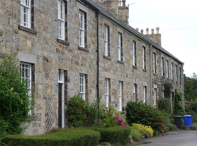
| Nos. 4-7, Church Street | 1233320 | II | c.1820 | Belford |
| Nos. 48 and 50, High Street | 1233467 | II | ||
| Nos. 52 and 54, High Street | 1233428 | II | ||
| Nos. 5a 5b and 7, High Street | 1233410 | II | ||
| Nos. 8 and 10, High Street | 1233423 | II | ||
| No. 9, High Street | 1233322 | II | ||
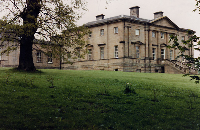
| Belford Hall | 1233314 | I | 1756 | Belford |
| Belford Hall (grounds) | 1001574 | II | C18th | Belford Listed park and garden |
| Belford Station | 1233783 | II | 1847 | Belford Former station building. |
| Enclosure and chapel, 295m north west of North Bank Cottage | 1006515 | n/a | Medieval | Scheduled Monument. Ruins |
| Belford Mains Farmhouse | 1233317 | II | 1820 | |
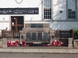
| Belford War Memorial | 1391869 | II | 1922 | Belford |
| Brown Headstone Circa 15 Yards East of Church of St Mary | 1276614 | II | 1814 | Belford |
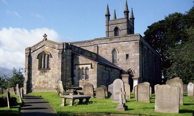
| Church of St Mary | 1276454 | II | C12th | Belford |
| Craggyhall Farmhouse and Attached Stable | 1276626 | II | C18th | Craggyhall |
| Erskine Manse | 1276433 | II | C18th | House, former Presbyterian manse. |
| Farmbuildings and Cottages Circa 60 Yards North of Newlands House | 1233773 | II | C18th | Newlands |
| Garages and Outbuildings South and West of the Blue Bell | 1233716 | II | c.1820 | |
| Garden Wall Circa 20 Yards East of Number 4 | 1233321 | II | C18th | Belford Clark Place |
| High Mousen Farmhouse | 1233776 | II | C19th | |
| Ice House Circa 40 Yards North of Belford Hall | 1233316 | II | c.1818 | |
| Limekiln Circa 1/2 Mile North of Warenton Farm | 1233778 | II | C18th | |
| Limekiln Circa 50 Yards North West of Craggyhall Farmhouse | 1233405 | II | C19th | Craggyhall |
| Limekiln Circa 700 Yards North of Warenton | 1233777 | II | C19th | |
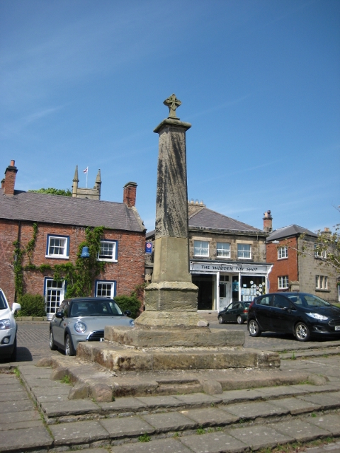
| Market Cross in Front of Blue Bell Hotel | 1276612 | II | C18th | Belford |
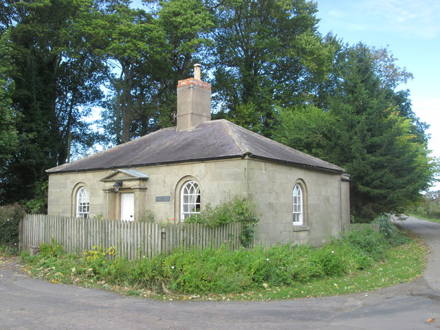
| Newlands East Lodge | 1233774 | II | C19th | Newlands |
| Newlands House | 1276431 | II | C18th | Newlands |
| Osborne House | 1233426 | II | ||
| South Gateway to Belford Hall | 1233416 | II | ||
| South Lodge to Belford Hall | 1276607 | II | ||
| Taits Shop W Pattersons Shop and Flats Above | 1233430 | II | ||
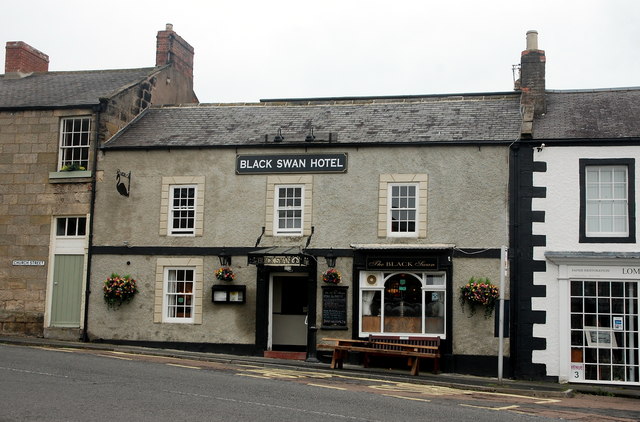
| The Black Swan Hotel | 1233429 | II | C19th | Belford |
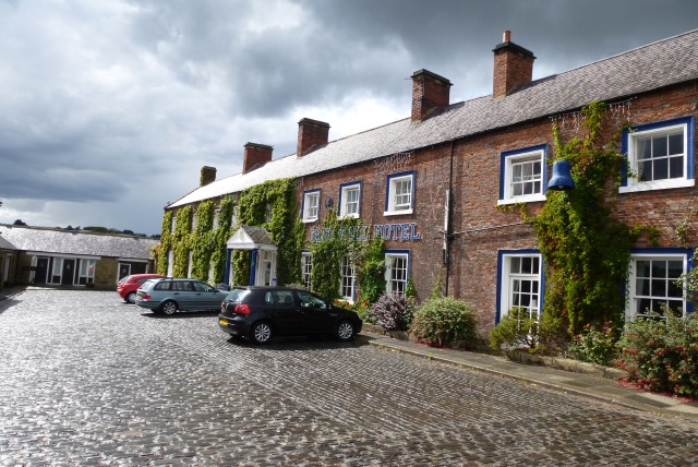
| The Blue Bell Hotel | 1233431 | II | C18th | Belford. Former coaching inn. |
| The Croft | 1276675 | II | ||
| The Old Vicarage | 1276432 | II | ||
| The Post Office | 1276672 | II | C19th | Belford House, now B&B. |
| The Villa | 1233323 | II | C19th | Belford High Street |
| Watch House Circa 20 Yards South West of Church of St Mary | 1233432 | II | ||
| Well Circa 10 Yards North of Westhall | 1233780 | II | ||
| Westhall Courtyard Wall and Attached Outbuildings | 1233779 | II | ||
| Limekiln Circa 600 Yards South West of Dicks Oldwalls | 1234460 | II | C19th | nr. Middleton |
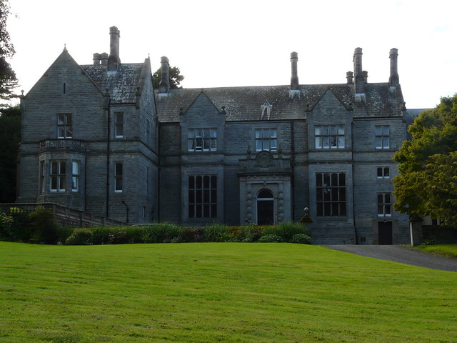
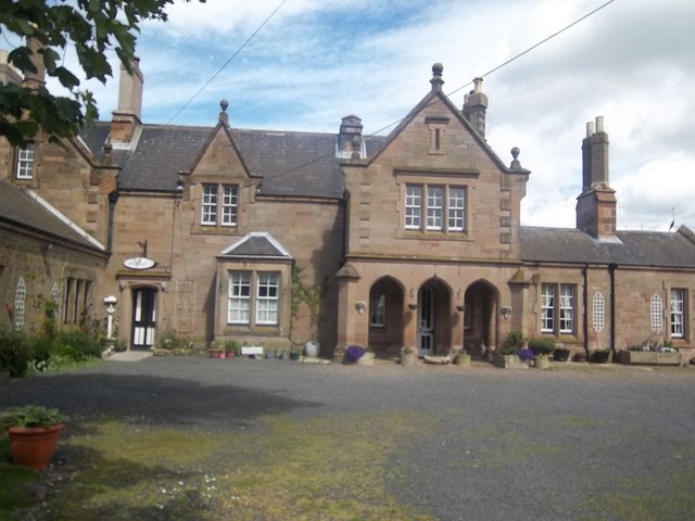
| Middleton Hall | 1233967 | II | 1871 | Middleton |
| Mill House | 1276157 | II | C18th | Middleton |
| Navigation Beacons at North End of Ross Links | 1233970 | II | nr. Middleton | |
| Old Farmhouse | 1234269 | II | nr Middleton | |
| Belford Conservation Area | - | n/a | Conservation Area |
Primary source: the National Heritage List for England - NHLE is the register of nationally protected historic buildings and sites in England, including listed buildings, scheduled monuments, protected wrecks, registered parks and gardens, and battlefields. The list is maintained by Historic England. Check NHLE for updates and new entries. Secondary sources: British Listed Buildings and Keys to the Past.
Co-Curate Page
Church of St. Mary
- Overview Map Street View St Mary's is the parish church of Belford. The church dates from the 12th century; the chancel was restored in 1828 by John Dobson. The nave …
Co-Curate Page
Belford War Memorial
- The war memorial in Belford was unveiled on the 26th of March 1922 by Dr. James McDonald, and dedicated by Rev. F. Goodburn Buffey.[1] The memorial, a "stone of remembrance", located …
Co-Curate Page
Belford Hall
- Overview About Belford Hall Map Belford Hall is a large country house at the north-east of Belford, built from 1754 to 1756 by James Paine for Abraham Dixon. It was …
Co-Curate Page
Market Cross
- Overview Map Street View The Market Cross stands in the Market Place in Belford, opposite the Blue Bell Hotel. The cross dates from the 18th or early 19th century, and it's …
Co-Curate Page
The Black Swan Hotel
- Overview Map Street View The Black swan Hotel is located at the north end of the Market Place in Belford. The inn was built in the early 19th century and …
Co-Curate Page
The Blue Bell Hotel
- Overview Map Street View The Blue Bell Hotel is located in the Market Place in Belford. It was built in the 18th century as a coaching inn. The Blue Bell …
Co-Curate Page
No. 1, Church Street, Belford
- No. 1 Church Street in Belford is an early 19th century house, which is Grade II listed on the National Heritage List for England.
Co-Curate Page
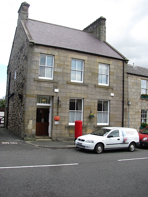
Post Office House
- Post Office House, no. 2 Church Street, in Belford is the former Post Office, now providing bed and breakfast accommodation. It was built in the mid-19th Century as post office, …
Co-Curate Page
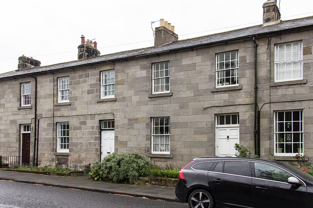
Nos. 4 - 7, Church Street, Belford
- Overview Map Street View Nos. 4 - 7, Church Street in Belford are a terrace of 4 houses built in c.1820. The houses are Grade II listed on the National Heritage …
Co-Curate Page
No. 3 Church Street, Belford
- Overview Map Street View No3, Church Street Belford was built in the 18th century and is the oldest house on the street. It is Grade II listed on the National Heritage …

Co-Curate Page
Nos 1 & 2, Clark Place
- Overview Map Street View The two houses at Nos 1 & 2 Clark Place in Belford, were formerly one house with an attached dairy. They were originally built in the …
Co-Curate Page
Nos 3, 4 & 5, Clark Place
- Overview Map Street View Nos 3, 4, & 5 are a terrace of three houses on Clark Place in Belford. They were built in c.1820, around the core of an earlier …
Co-Curate Page
Belford Station (1847 - 1968)
- Overview Map Street View Belford Station closed on the 29th of January 1968. The former station is located just over half a mile east of Belford. It was built in …

Co-Curate Page
Church of St. Mary
- Overview Map Street View St Mary's is the parish church of Belford. The church dates from the 12th century; the chancel was restored in 1828 by John Dobson. The nave …
Co-Curate Page
Belford War Memorial
- The war memorial in Belford was unveiled on the 26th of March 1922 by Dr. James McDonald, and dedicated by Rev. F. Goodburn Buffey.[1] The memorial, a "stone of remembrance", located …
Co-Curate Page
Belford Hall
- Overview About Belford Hall Map Belford Hall is a large country house at the north-east of Belford, built from 1754 to 1756 by James Paine for Abraham Dixon. It was …
Co-Curate Page
Market Cross
- Overview Map Street View The Market Cross stands in the Market Place in Belford, opposite the Blue Bell Hotel. The cross dates from the 18th or early 19th century, and it's …
Co-Curate Page
The Black Swan Hotel
- Overview Map Street View The Black swan Hotel is located at the north end of the Market Place in Belford. The inn was built in the early 19th century and …
Co-Curate Page
The Blue Bell Hotel
- Overview Map Street View The Blue Bell Hotel is located in the Market Place in Belford. It was built in the 18th century as a coaching inn. The Blue Bell …
Co-Curate Page
No. 1, Church Street, Belford
- No. 1 Church Street in Belford is an early 19th century house, which is Grade II listed on the National Heritage List for England.
Co-Curate Page
Post Office House
- Post Office House, no. 2 Church Street, in Belford is the former Post Office, now providing bed and breakfast accommodation. It was built in the mid-19th Century as post office, …
Co-Curate Page
Nos. 4 - 7, Church Street, Belford
- Overview Map Street View Nos. 4 - 7, Church Street in Belford are a terrace of 4 houses built in c.1820. The houses are Grade II listed on the National Heritage …
Co-Curate Page
No. 3 Church Street, Belford
- Overview Map Street View No3, Church Street Belford was built in the 18th century and is the oldest house on the street. It is Grade II listed on the National Heritage …
Co-Curate Page
Nos 1 & 2, Clark Place
- Overview Map Street View The two houses at Nos 1 & 2 Clark Place in Belford, were formerly one house with an attached dairy. They were originally built in the …
Co-Curate Page
Nos 3, 4 & 5, Clark Place
- Overview Map Street View Nos 3, 4, & 5 are a terrace of three houses on Clark Place in Belford. They were built in c.1820, around the core of an earlier …


