Topics > Northumberland > Haltwhistle > Haltwhistle Burn Roman Fortlets > Haltwhistle Burn Roman temporary camps 2 and 3 and area of cord rig cultivation
Haltwhistle Burn Roman temporary camps 2 and 3 and area of cord rig cultivation
Scheduled Monument (#1010946): Haltwhistle Burn Roman temporary camps 2 and 3 and area of cord rig cultivation
Click the headings below to expand (selected extracts from the Historic England scheduling)
The Haltwhistle Burn Roman temporary camps 2 and 3 and the area of cord rig cultivation survive well as upstanding earthworks. The rarity of temporary camps, and in particular examples with upstanding remains, identifies them as nationally important. Cord rig cultivation is late prehistoric in date and hence pre-dates the Roman sites in this area. Like later ridge and furrow earthworks, it was the product of organised arable cultivation. The higher rigs provided well-drained and warmer ground on which crops could be grown; the intervening furrows provided the soil for the rigs and also enhanced the drainage through the field system. Cord rig is found throughout the borders and provides an insight into the organisation and use of the landscape in the late prehistoric period. At Haltwhistle Burn the cord rig is well preserved and illustrates how the Roman frontier was established in a landscape that was already well used.
The monument includes the two Roman temporary camps, Haltwhistle Burn 2 and 3, and an area of cord rig cultivation ridges. These all survive as upstanding remains. The camps lie 100m south of the vallum and 100m north of the Stanegate Roman road. Camp 2 is the earlier and larger of the two camps. It was later divided in two by a rampart and ditch that extends east to west to form Camp 3, a smaller later camp. The camps are situated on a level shelf 30m to the ENE of Haltwhistle Burn Camp 1.
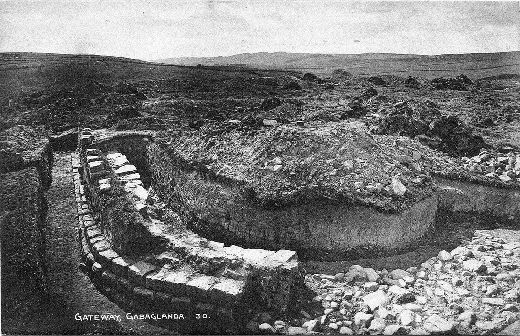
Camp 2 is square in plan, measuring 94m across and enclosing an area of 0.7ha. The rampart stands to a maximum height of 0.35m internally and the external ditch to a depth of 0.3m. There are three gateways to the camp, all of which are visible at the medial points in the north, south and east sides. Opposite each gateway are the remains of external defence banks up to 0.3m high with outer ditches up to 0.1m deep. There is no sign of a west gateway as this area has been eroded by a seasonal watercourse.
Camp 3 occupies the northern part of its predecessor, Camp 2, partly reusing its ramparts. It encloses an area of 0.3ha. The east rampart and ditch may have been reconstructed as they appear to be offset by about 1m from those of the earlier rampart of Camp 2. The new south rampart was provided with a gateway at its mid-point. This has a well preserved external defence bank 3.5m beyond the outer lip of the ditch. Within the camp are the turf-covered remains of two structures each 0.1m high. One is approximately square and is bounded by a bank with two stones exposed in the north east corner; the other is U-shaped with a depression in the centre.
An area of prehistoric cord rig cultivation lies 15m to the south of the ramparts of Camp 2. These cultivation ridges extend further south for 45m, occupying gently undulating ground.

from https://historicengland.org.u…
Haltwhistle Burn Roman temporary camps 2 and 3 and area of cord rig cultivation
- ".....The monument includes the two Roman temporary camps, Haltwhistle Burn 2 and 3, and an area of cord rig cultivation ridges. These all survive as upstanding remains. The camps lie …
Added by
Simon Cotterill