Topics > Civil Parishes in Cumbria > Winscales Civil Parish
Winscales Civil Parish
Parish boundaries may have changed - for the latest map see the Parish Council or Cumberland Council.
About the Parish
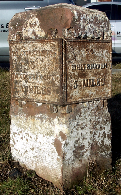
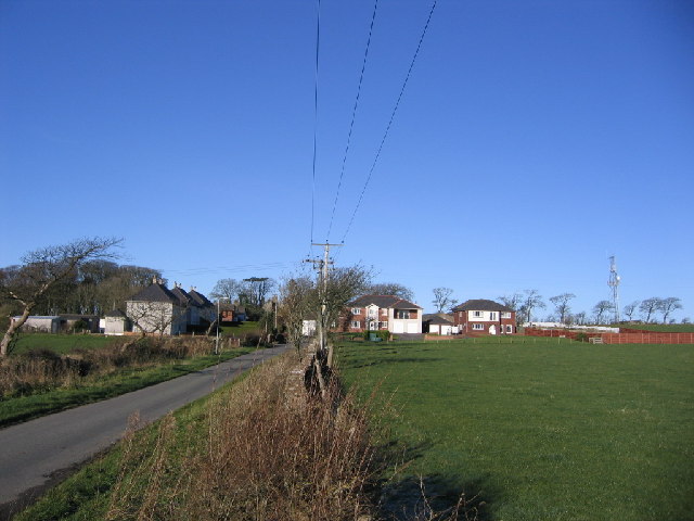
Winscales Civil Parish in Cumbria is located a short distance south-east of Workington and north of Distington. It is a mix of industrial areas (at the south of the parish), and rural and residential areas (including the hamlet of Winscales). The parish is intersected by the A595 road, which was the route old the Cockermouth-Whitehaven Turnpike Trust, founded in 1762, remembered by an old milestone.
| Main Settlements: |
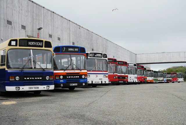
Winscales (hamlet), Wythemoor, Hunday The parish also includes Lillyhall business park and industrial estate, which was the site of Distington ironworks (1879 - 2007) and the former Leyland National bus factory (1971-1985). Lakes College moved from Workington to a purpose-built campus at Lillyhall in 2001. Along Jubilee Road / Branthwaite Road, towards Workington, is Workington Golf Club, The Fairways (care home), Branthwaite Academy (previously known as Cumbria Academy for Autism), and the site of the former Westlands Hotel (demolished) |
| Population: |
217 (2021 Census) 237 (2011 Census) 186 (2001 Census) |
| Area: | 10.7 km2 |
| Parish Council: | Winscales Parish Council |
| Unitary Authority: | Cumberland Council |
| Ceremonial County: | Cumbria |
Historical |
|
| Ancient Township: |
Population: 165 in 1811, 99 in 1911 Gazetteer: Winscales Township (Lewis, 1848) |
| Ancient Parish: |
Population: 6,533 in 1811, 25,065 in 1911 Gazetteer: Workington Parish (Lewis, 1848) Ancient parishes refer to the parishes before the split between ecclesiastical (church) and civil parishes in the 19th century. They had a parish church and often were composed of multiple townships and chapelries. In many cases, townships and parishes were originally based on the territory of manors from the feudal system during medieval times. Civil parishes were created following the Poor Law Amendment Act 1866, in which Church of England parishes, extra-parochial areas, townships and chapelries, became "civil parishes" which could set their own poor rate (tax). Then the reforms of Local Government Act 1894 established elected civil parish councils (or parish meetings for parishes with less than 300 residents) and created urban and rural districts. Boundaries of parishes and civil parishes may have changed over time. |
| Ancient District: |
Allerdale above Derwent (ward) |
| Poor Law Union: |
Cockermouth Poor Law Union, formed in 1838. Cockermouth Union Workhouse was located by Sullart Street in Cockermouth, opening in 1841. This replaced smaller existing workhouses in Cockermouth, Maryport and Workington. Under the Poor Law Amendment Act of 1834 parishes were grouped into Unions, each of which had to build a workhouse if they did not already have one. It ended the old system of locally provided poor relief which had come under strain as numbers out of work grew, following increasing mechanisation of agriculture and the economic downturn after the Napoleonic Wars, along with changing social attitudes. The workhouse provided those unable to support themselves financially with accommodation and work. Inmates were generally segregated into men, women, boys and girls. The workhouse system was abolished by the Local Government Act 1929, but many workhouses lived on as ‘Public Assistance Institutions’ until the National Assistance Act 1948. |
| Major Boundary Change |
Winscales CP gained 1,677 acres in April 1934 - parts of Stainburn CP and Workington Rural CP. |
| County: |
Cumberland, until 1974, then: Cumbria, which was created on the 1st of April 1974, following the Local Government Act 1972. The new county absorbed Cumberland and Westmorland, and added some parts of Lancashire and the West Riding of Yorkshire. Cumbria County Council was abolished in 2023 and replaced by 2 new Unitary authorities. Cumbria remains a ceremonial county; retaining ceremonial boundary and the roles and responsibilities of the Lord Lieutenant and High Sheriff of Cumbria - based on 'The Cumbria (Structural Changes) Order 2022'. |
|
District Council: |
Cockermouth Rural District (1894 - 1974) Allerdale Borough (1974 - 2023) Created by the Local Government Act 1972. Allerdale absorbed the former municipal borough of Workington; the urban districts of Maryport, Cockermouth and Keswick; and the rural districts of Cockermouth and Wigton. Allerdale and the 5 other district councils of Cumbria, along with the county council, were abolished as part of local government reorganisation in 2023; and replaced by two unitary authorities on 1st April 2023. |
|
Unitary Authoroity: |
Cumberland Council was created on the 1st April 2023. The 'new' Cumberland unitary authority area includes most of the historic county, with the exception of Penrith and it's surrounding area, which is part the 'new' Westmorland and Furness unitary authority. |
Listed buildings and scheduled monuments in Winscales Civil Parish, Cumbria, from the National Heritage List for England.
| Structure | List No. | Grade | Built~ | Note |
|---|---|---|---|---|
| Milestone East of Distington Secondary School | 1312130 | II | C18th | A595, Winscales |
| Wythemoor Sough and Adjoining Barn and Stable | 1327185 | II | C18th |
Primary source: the National Heritage List for England - NHLE is the register of nationally protected historic buildings and sites in England, including listed buildings, scheduled monuments, protected wrecks, registered parks and gardens, and battlefields. The list is maintained by Historic England. Check NHLE for updates and new entries. Secondary sources: British Listed Buildings.
Co-Curate Page
Old Milestone, A595, Winscales
- This milestone is located by the A595, in Winscales, just north of Distington. It was errected in the late 18th or early 19th century for the Cockermouth-Whitehaven Turnpike. It is …
Co-Curate Page
Winscales
- Overview Map Street View Winscales is a hamlet in Cumbria, located north of the village of Distington and about 2 miles east of Workington. The hamlet includes Oily's public house …

from Geograph (geograph)
Inside a fuel pump at the former Leyland National bus factory, Lillyhall
Pinned by Simon Cotterill
from Geograph (geograph)
A National lineup at the former British Leyland bus factory, Lillyhall
Pinned by Simon Cotterill


from https://www.winscalesparishco…
Winscales Parish Council
- Website of Winscales Parish Council
Added by
Simon Cotterill

from https://www.cumbriacountyhist…
Winscales
- ....Township in Workington parish, in Allerdale above Derwent ward, Cumberland. Winscales CP gained parts of Stainburn and Workington Rural CPs 1934.....
Added by
Simon Cotterill


Co-Curate Page
Old Milestone, A595, Winscales
- This milestone is located by the A595, in Winscales, just north of Distington. It was errected in the late 18th or early 19th century for the Cockermouth-Whitehaven Turnpike. It is …
Co-Curate Page
Winscales
- Overview Map Street View Winscales is a hamlet in Cumbria, located north of the village of Distington and about 2 miles east of Workington. The hamlet includes Oily's public house …
from Geograph (geograph)
Inside a fuel pump at the former Leyland National bus factory, Lillyhall
Pinned by Simon Cotterill
from Geograph (geograph)
A National lineup at the former British Leyland bus factory, Lillyhall
Pinned by Simon Cotterill
from https://www.winscalesparishco…
Winscales Parish Council
- Website of Winscales Parish Council
Added by
Simon Cotterill
from https://www.cumbriacountyhist…
Winscales
- ....Township in Workington parish, in Allerdale above Derwent ward, Cumberland. Winscales CP gained parts of Stainburn and Workington Rural CPs 1934.....
Added by
Simon Cotterill


