Topics > Heritage Sites > Hadrian's Wall > Wall Mile 79
Wall Mile 79
Hadrian's Wall: Wall Mile 79
Hadrian's Wall stretches from the east to west coast of England and was an important frontier of the Roman Empire. Building of the wall began in AD 122 and took six years to complete it’s 84 mile (80 Roman mile) length. Soldiers were garrisoned along the line of the wall in large forts, smaller milecastles, and intervening turrets. The Vallum, a large ditch with mounds on either side, ran along the south side of the wall, protecting the rear of the frontier. Hadrian's Wall was designated as a World Heritage Site in 1987.
Wall mile 79 was originally part of the turf wall, later replaced by stone. From Milecastle 49 to the western end of Hadrian's Wall on the Solway Firth, the wall was originally constructed from turf, possibly due to the absence of limestone. Subsequently, the turf wall was demolished and replaced with a stone wall.
Wall Mile 79:
- Milecastle 79 (Solway House) - no visible surface remains
- Turret 79a - exact location unknown
- Turret 79b (Jeffrey Croft) - field, no visible surface remains
- Knockcross Roman Temporary Camp - no visible surface remains
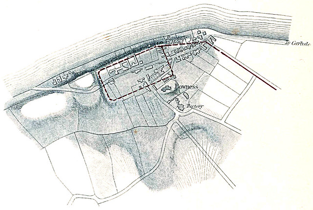
Scheduled Monument (#1015951): Hadrian's Wall between Port Carlisle and Bowness-on-Solway in wall miles 78 and 79
Click the headings below to expand (selected extracts from the Historic England scheduling)
Map showing the buried remains of Hadrian's Wall in this section (Scheduled Monument area).
%
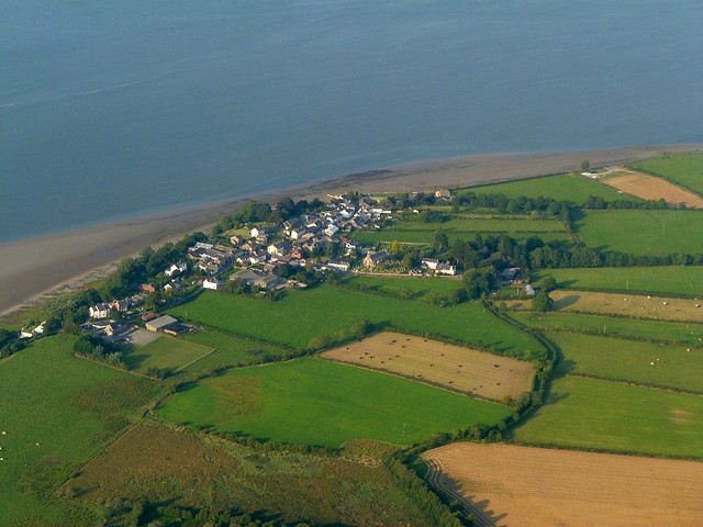
Hadrian's Wall runs westwards along the crest of a raised beach from Port Carlisle for 700m and then turns north west to run towards Bowness-on-Solway. West of the site of milecastle 79, for a distance of 200m, the remains of the Wall lie beneath a field boundary visible as a bank 1m high surmounted by a hedge. The indications are that the Wall survives as upstanding remains of the core and probably also the faces several courses high with undisturbed tumble on either side beneath the earth bank. At the west end of this length the Wall is exposed either side of a modern field gate, standing up to four courses high with the footing flags exposed across the gateway. However, around the site of milecastle 79 and west of the north westerly turn in direction the Wall survives as a buried feature with no visible indications on the ground. The Wall in this sector was initially constructed in turf, which was replaced on the same line in the second half of the second century AD by the Stone Wall. It has not yet been determined whether the Wall was fronted by a ditch in this section. The proximity of the coast would have made a ditch superfluous and a ditch of the normal wall ditch proportions would have been liable to tidal flooding.
Milecastle 79 is situated 350m west of Field View Lane. Excavations of the milecastle were undertaken in 1949 by Richmond and Gillam. Like all milecastles in the western part of Hadrian's Wall, it was originally constructed with turf ramparts and timber gateways and internal buildings. It measured 14.9m east to west and 12.5m north to south internally. This was replaced at some time in the second half of the second century by a stone built milecastle which measured 17.7m internally. The gates of the stone milecastle were found to have been reduced in size after the initial construction. A timber framed building is also known to have stood in the eastern half of the stone milecastle.
The exact position of Turret 79a has not yet been confirmed. On the basis of the usual spacing it is expected to be located approximately 400m west of milecastle 79 where the Wall changes direction. Turret 79a is expected to survive as buried remains.
Turret 79b is situated approximately 250m south east of the houses at the east end of Bowness-on-Solway in the field known as Jeffrey Croft. Its site is indicated by a very slight platform, visible on the ground. It was partly excavated in 1934 by Simpson, Richmond and MacIntyre to confirm whether the Turf Wall extended westwards as far as the west end of Hadrian's Wall at Bowness. The south wall was found to be 1.12m wide and the west wall, 0.96m wide, was traced for 4.64m from the south west corner. It was constructed on a foundation of two layers of cobbles sandwiched in red clay, with three courses of masonry surviving above. The difference in thickness of the south and west walls and the evidence that it was originally built as a free-standing tower abutted by the Turf Wall demonstrated it to be the type of turret characteristic of the Turf Wall, and the most westerly turret known on Hadrian's Wall. When the Wall was rebuilt in stone, the Turf Wall turrets, which were originally built in stone themselves, were retained with the new wall.
The course of the Roman road known as the Military Way, which ran along the corridor between the Wall and vallum linking turrets, milecastles and forts, has not been confirmed in this section. It is expected to run parallel to the Wall a few metres from its south face.
Scheduled Monument (#1016021): Hadrian's Wall vallum between the track south of Kirkland House and Bowness-on-Solway in wall miles 78 and 79
Click the headings below to expand (selected extracts from the Historic England scheduling)
Map showing the buried remains of Hadrian's Wall vallum in this section (Scheduled Monument area).
%
The course of the vallum is known in this section with intermittent surface traces visible. The vallum ditch survives as a faint shallow depression and a short section of the south mound is visible as an earthwork averaging 0.5m high to the south west of milecastle 79. Elsewhere the vallum mounds are not visible on the ground and survive as buried remains.
The course of the vallum westwards is not known from a point 150m west of the measured site of turret 79a, and its western terminus has not yet been discovered.

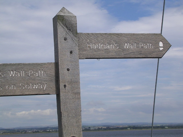


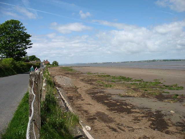
from Geograph (geograph)
The Hadrian's Wall Path approaching Bowness-on-Solway
Pinned by Simon Cotterill

from https://historicengland.org.u…
Hadrian's Wall between Port Carlisle and Bowness-on-Solway in wall miles 78 and 79 - List Entry
- ....Hadrian's Wall runs westwards along the crest of a raised beach from Port Carlisle for 700m and then turns north west to run towards Bowness-on-Solway. West of the site of …
Added by
Simon Cotterill
from https://historicengland.org.u…
Hadrian's Wall vallum between the track south of Kirkland House and Bowness-on-Solway in wall miles 78 and 79
- ....The section of the vallum between the track south of Kirkland House and Bowness-on-Solway survives well as a visible earthwork in part of the monument and elsewhere as buried remains. …
Added by
Simon Cotterill

from https://perlineamvalli.wordpr…
Wall Mile 79
- Wall Mile 79 (September 2, 2011). "Our first mile of the Wall to the south-east of Bowness fort is a field boundary, some way to the south of the Trail, …
Added by
Simon Cotterill
from https://www.heritagegateway.o…
Milecastle 79
- Hob Uid: 10106
Location :
Cumbria
Allerdale
Bowness
Grid Ref : NY2359062240
Summary : The site of Roman Milecastle 79, part of the defences supporting Hadrian's Wall along the Cumbrian …
Added by
Simon Cotterill
from https://www.heritagegateway.o…
Turret 79b
- Hob Uid: 10089
Location :
Cumbria
Allerdale
Bowness
Grid Ref : NY2283062560
Summary : The site of Roman turret 79B, part of the defences supporting Hadrian's Wall along the Cumbrian …
Added by
Simon Cotterill

Co-Curate Page
Knockcross Roman temporary camp
- Overview Map The site of the Roman temporary camp known as Knockcross is located at Grey Havens (house), about ½mile east of Bowness‑on‑Solway and 190m north of Hadrian’s Wall. Although …

from Geograph (geograph)
The Hadrian's Wall Path approaching Bowness-on-Solway
Pinned by Simon Cotterill
from https://historicengland.org.u…
Hadrian's Wall between Port Carlisle and Bowness-on-Solway in wall miles 78 and 79 - List Entry
- ....Hadrian's Wall runs westwards along the crest of a raised beach from Port Carlisle for 700m and then turns north west to run towards Bowness-on-Solway. West of the site of …
Added by
Simon Cotterill
from https://historicengland.org.u…
Hadrian's Wall vallum between the track south of Kirkland House and Bowness-on-Solway in wall miles 78 and 79
- ....The section of the vallum between the track south of Kirkland House and Bowness-on-Solway survives well as a visible earthwork in part of the monument and elsewhere as buried remains. …
Added by
Simon Cotterill
from https://perlineamvalli.wordpr…
Wall Mile 79
- Wall Mile 79 (September 2, 2011). "Our first mile of the Wall to the south-east of Bowness fort is a field boundary, some way to the south of the Trail, …
Added by
Simon Cotterill
from https://www.heritagegateway.o…
Milecastle 79
- Hob Uid: 10106
Location :
Cumbria
Allerdale
Bowness
Grid Ref : NY2359062240
Summary : The site of Roman Milecastle 79, part of the defences supporting Hadrian's Wall along the Cumbrian …
Added by
Simon Cotterill
from https://www.heritagegateway.o…
Turret 79b
- Hob Uid: 10089
Location :
Cumbria
Allerdale
Bowness
Grid Ref : NY2283062560
Summary : The site of Roman turret 79B, part of the defences supporting Hadrian's Wall along the Cumbrian …
Added by
Simon Cotterill


