Topics > Heritage Sites > Hadrian's Wall > Wall Mile 78
Wall Mile 78
Hadrian's Wall - Wall Mile 78
Hadrian's Wall stretches from the east to west coast of England and was an important frontier of the Roman Empire. Building of the wall began in AD 122 and took six years to complete it’s 84 mile (80 Roman mile) length. Soldiers were garrisoned along the line of the wall in large forts, smaller milecastles, and intervening turrets. The Vallum, a large ditch with mounds on either side, ran along the south side of the wall, protecting the rear of the frontier. Hadrian's Wall was designated as a World Heritage Site in 1987.
Wall mile 78 was originally part of the turf wall, later replaced by stone. From Milecastle 49 to the western end of Hadrian's Wall on the Solway Firth, the wall was originally constructed from turf, possibly due to the absence of limestone. Subsequently, the turf wall was demolished and replaced with a stone wall.
Wall Mile 78:
- Milecastle 78 (Kirkland) - no visible surface remains
- Turret 78a (Kirkland) - no visible surface remains
- Turret 78b - exact location unknown
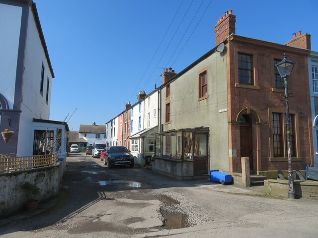
The Wall survives as a buried feature in Wall Mile 78. The site of Milecastle 78 is located between the villages of Glasson and Port Carlisle. Turret 78a lies in the hedge line, 20 metres northwest of the Kirkland House (farm). Some traces of the vallum can still be seen. Hadrian's Way Path national trail follows close to the line of The Wall in parallel with the Solway Firth. East of Port Carlisle, the path follows the old railway line, which interestingly was built over the Carlise Canal in the mid-19th century.
Scheduled Monument (#1014701): Hadrian's Wall and vallum between the access road to Glendale caravan park and the track south of Kirkland House in wall miles 77 and 78
Click the headings below to expand (selected extracts from the Historic England scheduling)
Map showing the buried remains of Hadrian's Wall and vallum in this section (Scheduled Monument area).
%
Hadrian's Wall survives throughout this section as a buried feature. West of milecastle 78 the Wall turns northwards to follow the Solway coast in contrast to the vallum which runs straight in this section. It is not certain whether the ditch to the north of the Wall was provided in this section, as a ditch would have been superfluous so close to the shore and liable to tidal flooding. There is no evidence for the ditch on its depicted line. The Wall in this sector was initially constructed in turf, which was replaced in the second half of the second century by the stone wall.
Milecastle 78 was located and partly excavated in 1934 by Simpson, Richmond and MacIntyre. It is situated 110m north west of the access road to Glendale caravan park. Only the west wall was examined in the excavations and was found to be 2.8m wide. One course of masonry survived of the inner face above the footings, but the outer face had been robbed. The overall dimensions of the milecastle are not yet known.
Like all milecastles in the western part of Hadrian's Wall, it was originally built with turf ramparts and timber gateways and buildings, but was replaced in stone in the second half of the second century. The remains of the stone milecastle survive as buried remains. The excavators did not record whether remains of the primary turf and timber phase of the milecastle survive, but they are likely to survive beneath and alongside the remains of the stone milecastle also as buried remains.
The course of the Roman road known as the Military Way, which ran along the corridor between the Wall and the vallum linking turrets, milecastles and forts, has not been confirmed in this section.
The course of the vallum is known in this section. The vallum ditch can be traced as a depression up to 0.8m deep. The vallum mounds are not visible in this section and have been reduced and levelled by ploughing. They survive as buried features.
Scheduled Monument (#1016075): Hadrian's Wall north of Kirkland House, Port Carlisle in wall mile 78
Click the headings below to expand (selected extracts from the Historic England scheduling)
Map showing the buried remains of Hadrian's Wall in this section (Scheduled Monument area).
%
Hadrian's Wall survives here as buried remains with no indications visible on the ground. However its course is known here from the identification of turret 78a in the 18th century by the antiquarian John Horsley, and excavation in 1948 by Simpson, Richmond and Hodgson confirmed the location.
The remains of turret 78a survive as buried remains under the hedge on the south side of the road to Port Carlisle 30m north of Kirkland House Farm.
Scheduled Monument (#1015951): Hadrian's Wall between Port Carlisle and Bowness-on-Solway in wall miles 78 and 79
Click the headings below to expand (selected extracts from the Historic England scheduling)
Map showing the buried remains of Hadrian's Wall in this section (Scheduled Monument area).
%
Hadrian's Wall runs westwards along the crest of a raised beach from Port Carlisle for 700m and then turns north west to run towards Bowness-on-Solway. West of the site of milecastle 79, for a distance of 200m, the remains of the Wall lie beneath a field boundary visible as a bank 1m high surmounted by a hedge. The indications are that the Wall survives as upstanding remains of the core and probably also the faces several courses high with undisturbed tumble on either side beneath the earth bank. At the west end of this length the Wall is exposed either side of a modern field gate, standing up to four courses high with the footing flags exposed across the gateway. However, around the site of milecastle 79 and west of the north westerly turn in direction the Wall survives as a buried feature with no visible indications on the ground. The Wall in this sector was initially constructed in turf, which was replaced on the same line in the second half of the second century AD by the Stone Wall. It has not yet been determined whether the Wall was fronted by a ditch in this section. The proximity of the coast would have made a ditch superfluous and a ditch of the normal wall ditch proportions would have been liable to tidal flooding.
The course of the Roman road known as the Military Way, which ran along the corridor between the Wall and vallum linking turrets, milecastles and forts, has not been confirmed in this section. It is expected to run parallel to the Wall a few metres from its south face.
Scheduled Monument (#1016021): Hadrian's Wall vallum between the track south of Kirkland House and Bowness-on-Solway in wall miles 78 and 79
Click the headings below to expand (selected extracts from the Historic England scheduling)
Map showing the buried remains of Hadrian's Wall vallum in this section (Scheduled Monument area).
%
The course of the vallum is known in this section with intermittent surface traces visible. The vallum ditch survives as a faint shallow depression and a short section of the south mound is visible as an earthwork averaging 0.5m high to the south west of milecastle 79. Elsewhere the vallum mounds are not visible on the ground and survive as buried remains.
The course of the vallum westwards is not known from a point 150m west of the measured site of turret 79a, and its western terminus has not yet been discovered.


from https://historicengland.org.u…
Hadrian's Wall between Port Carlisle and Bowness-on-Solway in wall miles 78 and 79 - List Entry
- ....Hadrian's Wall runs westwards along the crest of a raised beach from Port Carlisle for 700m and then turns north west to run towards Bowness-on-Solway. West of the site of …
Added by
Simon Cotterill
from https://historicengland.org.u…
Hadrian's Wall vallum between the track south of Kirkland House and Bowness-on-Solway in wall miles 78 and 79
- ....The section of the vallum between the track south of Kirkland House and Bowness-on-Solway survives well as a visible earthwork in part of the monument and elsewhere as buried remains. …
Added by
Simon Cotterill
from https://historicengland.org.u…
Hadrian's Wall north of Kirkland House, Port Carlisle in wall mile 78 - List Entry
- ...Hadrian's Wall survives here as buried remains with no indications visible on the ground. However its course is known here from the identification of turret 78a in the 18th century …
Added by
Simon Cotterill
from https://historicengland.org.u…
Hadrian's Wall and vallum between the access road to Glendale caravan park and the track south of Kirkland House in wall miles 77 and 78 - List Entry
- ....Hadrian's Wall and vallum including the remains of Milecastle 78 between the access road to Glendale caravan park and the track south of Kirkland House survive well as buried remains. …
Added by
Simon Cotterill


from https://perlineamvalli.wordpr…
Wall Mile 78
- Wall Mile 78 (September 4, 2011). Mike Bishop's PLV blog about walking Hadrian’s Wall written from an archaeologist’s point of view. "Now we should proceed towards Port Carlisle, still on …
Added by
Simon Cotterill
from https://www.heritagegateway.o…
Milecastle 78
- Hob Uid: 10134
Location :
Cumbria
Allerdale
Bowness
Grid Ref : NY2450061300
Summary : The approximate site of Roman milecastle 78 at Kirkland. There are no visible remains. The site …
Added by
Simon Cotterill
from https://www.heritagegateway.o…
Turret 78a
- Hob Uid: 10137
Location :
Cumbria
Allerdale
Bowness
Grid Ref : NY2431061750
Summary : The approximate site of Roman turret 78A, part of the defences supporting Hadrian's wall along the …
Added by
Simon Cotterill

from https://historicengland.org.u…
Hadrian's Wall between Port Carlisle and Bowness-on-Solway in wall miles 78 and 79 - List Entry
- ....Hadrian's Wall runs westwards along the crest of a raised beach from Port Carlisle for 700m and then turns north west to run towards Bowness-on-Solway. West of the site of …
Added by
Simon Cotterill
from https://historicengland.org.u…
Hadrian's Wall vallum between the track south of Kirkland House and Bowness-on-Solway in wall miles 78 and 79
- ....The section of the vallum between the track south of Kirkland House and Bowness-on-Solway survives well as a visible earthwork in part of the monument and elsewhere as buried remains. …
Added by
Simon Cotterill
from https://historicengland.org.u…
Hadrian's Wall north of Kirkland House, Port Carlisle in wall mile 78 - List Entry
- ...Hadrian's Wall survives here as buried remains with no indications visible on the ground. However its course is known here from the identification of turret 78a in the 18th century …
Added by
Simon Cotterill
from https://historicengland.org.u…
Hadrian's Wall and vallum between the access road to Glendale caravan park and the track south of Kirkland House in wall miles 77 and 78 - List Entry
- ....Hadrian's Wall and vallum including the remains of Milecastle 78 between the access road to Glendale caravan park and the track south of Kirkland House survive well as buried remains. …
Added by
Simon Cotterill
from https://perlineamvalli.wordpr…
Wall Mile 78
- Wall Mile 78 (September 4, 2011). Mike Bishop's PLV blog about walking Hadrian’s Wall written from an archaeologist’s point of view. "Now we should proceed towards Port Carlisle, still on …
Added by
Simon Cotterill
from https://www.heritagegateway.o…
Milecastle 78
- Hob Uid: 10134
Location :
Cumbria
Allerdale
Bowness
Grid Ref : NY2450061300
Summary : The approximate site of Roman milecastle 78 at Kirkland. There are no visible remains. The site …
Added by
Simon Cotterill
from https://www.heritagegateway.o…
Turret 78a
- Hob Uid: 10137
Location :
Cumbria
Allerdale
Bowness
Grid Ref : NY2431061750
Summary : The approximate site of Roman turret 78A, part of the defences supporting Hadrian's wall along the …
Added by
Simon Cotterill


")