Topics > Heritage Sites > Hadrian's Wall > Wall Mile 52
Wall Mile 52
Hadrian's Wall - Wall Mile 52
Hadrian's Wall stretches from the east to west coast of England and was an important frontier of the Roman Empire. Building of the wall began in AD 122 and took six years to complete it’s 84 mile (80 Roman mile) length. Soldiers were garrisoned along the line of the wall in large forts, smaller milecastles, and intervening turrets. The Vallum, a large ditch with mounds on either side, ran along the south side of the wall, protecting the rear of the frontier. Hadrian's Wall was designated as a World Heritage Site in 1987.
Wall mile 52 was originally a turf wall, later replaced by stone. From Milecastle 49 to the western end of Hadrian's Wall on the Solway Firth, the wall was originally constructed from turf, possibly due to the absence of limestone. Subsequently, the turf wall was demolished and replaced with a stone wall.
Wall Mile 52:
- Milecastle 52 - no visible remains (overlain by Bankshead House).
- Pike Hill Signal Tower - significant visible remains
- Turret 52a (Banks East) - significant visible remains.
- Turret 52b - no visible remains
Scheduled Ancient Monument (#1010996): Hadrian's Wall and vallum between the field boundary west of Coombe Crag and Banks Green Cottage and the road to Lanercost at Banks in wall miles 51 and 52
Click the headings below to expand (selected extracts from the Historic England scheduling)
%
Hadrian's Wall survives mostly as a buried feature throughout this section except for short lengths of exposed Wall either side of the turrets and Pike Hill Tower. Where exposed the Wall measures 2.35m wide and up to 1.25m high. Elsewhere the Wall survives as a buried feature below the surface of the modern road or as a turf covered discontinuous robber trench east of turret 51a. Between turrets 51a and 51b the course of the Wall is overlain by the roadside wall. The wall ditch survives as a well preserved earthwork visible on the ground throughout most of this section.
Pike Hill Tower is situated on the highest point along the ridge occupied by the Wall with extensive views in all directions. The turret survives as an exposed stone feature. It is positioned at 45 degrees to the Wall line which zig-zags to accommodate it. Its exceptionally deep foundations suggest that it was higher than the average turret. Consequently this tower is believed to be a signal tower built before the Wall system and later incorporated into it. The tower was partly destroyed in 1870 when the road was drastically lowered. Excavation in 1931 by Simpson revealed the one remaining corner and a ground floor door together with Roman pottery of various dates.
See our page: Pike Hill Signal Tower
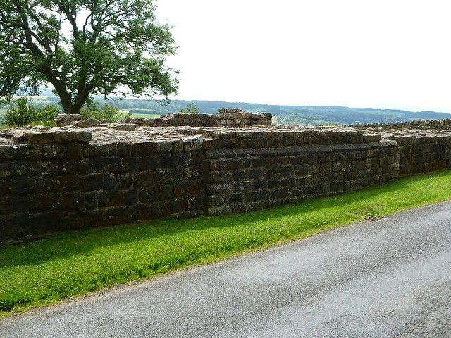
Turret 52a, known as Banks East Turret, is situated 170m west of Pike Hill Tower. It survives as an upstanding stone feature. Its walls stand up to 14 courses giving a maximum height of 1.75m. Excavations in 1933 by Simpson and Richmond found remains of the demolished Turf Wall abutting its east wall. It was used continuously until at least the end of the third century AD.
See our page: Turret 52a (Banks East)
The exact location of turret 52b has not yet been confirmed. There are no upstanding remains visible above ground. On the basis of the usual spacing it is expected to survive about 15m east of Glen View below the surface of the modern road.
The exact course of the Roman road known as the Military Way, which ran along the corridor between the Wall and the vallum linking the turrets, milecastles and forts, is known intermittently throughout this section where it survives as an earthwork feature. Opposite the disused quarry west of Bankshead Farm the Military Way survives as a terrace, 3m-5m wide, on the north side of an old hedge line. Occasional rises in hedgelines denote traces of its course.
The vallum survives intermittently as an upstanding earthwork visible on the ground throughout this section. It is best preserved at the east end of this section where the ditch averages 2.5m deep to the north, and the north and south mounds are nowhere more than 0.6m high. Elsewhere the vallum survives either as a ploughed down scarp up to 0.9m high and the ditch 0.8m deep, or there are no surface traces at all. Excavations in the vicinity of Pike Hill Tower in 1932 by Simpson found the ditch to be rock cut for at least 46m and crossings were noted at 41.5m intervals in the south mound. Excavations in advance of construction work at Banks in 1977 by Austen identified the north edge of the vallum ditch.
Scheduled Ancient Monument (#1010997): Hadrian's Wall and vallum between Banks Green Cottage and the road to Lanercost at Banks and the road to Garthside in wall miles 52, 53 and 54
Click the headings below to expand (selected extracts from the Historic England scheduling)
%
Hadrian's Wall survives as a buried feature throughout most of this section overlain in parts by the modern road, fields given to pasture, gardens and field walls. A few remains are visible above ground including the well preserved section of Wall at Hare Hill. Here the core of the Wall is original but part of the face has been reconstructed. It stands to a maximum height of 3.6m and is 2.3m wide. It is consolidated and in the care of the Secretary of State. West of Burtholme Beck there is a length of mortared wall core which stands 1.7m high. Further west there is a shorter stretch of wall core on the same hedge line, 1.3m high. To the east of turret 54a the Wall survives as a substantial turf covered bank at the base of a mature hedge. The wall ditch survives intermittently as an earthwork in this section. It is best preserved between Hare Hill and Haytongate where it averages 2m deep throughout. It has a maximum depth of 3.2m in parts. Elsewhere the ditch averages 1.8m where extant, but otherwise lies buried below the turf cover or is visible as a slight depression. The ditch upcast mound, usually referred to as the glacis, survives in places to the north of the ditch as an amorphous low mound.
The exact course of the Roman road known as the Military Way, which ran along the corridor between the Wall and vallum linking turrets, milecastles and forts, is not yet confirmed in this section. The only traces visible on the ground are two stretches of a low slight swelling, one west of milecastle 54 and the other about 200m east of turret 53b. Elsewhere it survives as a buried feature with no remains visible above ground.
The vallum survives as an earthwork visible on the ground throughout most of this section. The ditch averages between 1.6m and 2m deep where extant. Elsewhere it is silted up and is overlain by the turf cover. The north mound averages between 0.3m and 0.9m high and the south mound 0.3m and 1.3m high. The vallum was trenched in two places on Hare Hill, first in 1894 and again in 1903 by Haverfield. The north and south mounds were found together with the marginal mounds. The supposed Roman camp shown to the immediate south of the vallum in Abbey Park Wood is no longer identified as Roman.
Turret 52A (Banks East):


from https://historicengland.org.u…
Hadrian's Wall and vallum between the field boundary west of Coombe Crag and Banks Green Cottage and the road to Lanercost at Banks in wall miles 51 and 52 - List Entry
- ....The monument includes the section of Hadrian's Wall and vallum and their associated features between the field boundary west of Coombe Crag in the east and Banks Green Cottage and …
Added by
Simon Cotterill
from https://historicengland.org.u…
Hadrian's Wall and vallum between Banks Green Cottage and the road to Lanercost at Banks and the road to Garthside in wall miles 52, 53 and 54 - List Entry
- ....The monument includes the section of Hadrian's Wall and vallum and their associated features between Banks Green Cottage and the road to Lanercost at Banks in the east and the …
Added by
Simon Cotterill


from https://perlineamvalli.wordpr…
Wall Mile 52
- Wall Mile 52 (December 3, 2011). Mike Bishop's PLV blog about walking Hadrian’s Wall written from an archaeologist’s point of view. "Consideration was once given to consolidating a length of …
Added by
Simon Cotterill

from https://historicengland.org.u…
Hadrian's Wall and vallum between the field boundary west of Coombe Crag and Banks Green Cottage and the road to Lanercost at Banks in wall miles 51 and 52 - List Entry
- ....The monument includes the section of Hadrian's Wall and vallum and their associated features between the field boundary west of Coombe Crag in the east and Banks Green Cottage and …
Added by
Simon Cotterill
from https://historicengland.org.u…
Hadrian's Wall and vallum between Banks Green Cottage and the road to Lanercost at Banks and the road to Garthside in wall miles 52, 53 and 54 - List Entry
- ....The monument includes the section of Hadrian's Wall and vallum and their associated features between Banks Green Cottage and the road to Lanercost at Banks in the east and the …
Added by
Simon Cotterill
from https://perlineamvalli.wordpr…
Wall Mile 52
- Wall Mile 52 (December 3, 2011). Mike Bishop's PLV blog about walking Hadrian’s Wall written from an archaeologist’s point of view. "Consideration was once given to consolidating a length of …
Added by
Simon Cotterill


 NE of Whitley Castle")

