Topics > Heritage Sites > Hadrian's Wall > Wall Mile 51
Wall Mile 51
Hadrian's Wall - Wall Mile 51
Hadrian's Wall stretches from the east to west coast of England and was an important frontier of the Roman Empire. Building of the wall began in AD 122 and took six years to complete it’s 84 mile (80 Roman mile) length. Soldiers were garrisoned along the line of the wall in large forts, smaller milecastles, and intervening turrets. The Vallum, a large ditch with mounds on either side, ran along the south side of the wall, protecting the rear of the frontier. Hadrian's Wall was designated as a World Heritage Site in 1987.
Wall mile 51 was originally a turf wall, later replaced by stone. From Milecastle 49 to the western end of Hadrian's Wall on the Solway Firth, the wall was originally constructed from turf, possibly due to the absence of limestone. Subsequently, the turf wall was demolished and replaced with a stone wall.
Wall Mile 51:
- Milecastle 51 (Wall Bowers) - turf covered foundations with traces of the vallum
- Turret 51a (Piper Sike) - significant visible remains
- Turret 51b (Leahill) - significant visible remains
Scheduled Ancient Monument (#1010995): Hadrian's Wall and vallum between the field boundaries east of milecastle 50 and the boundary west of Coombe Crag in wall miles 50 and 51
Click the headings below to expand (selected extracts from the Historic England scheduling)
%
The monument includes the section of Turf and Stone Walls and vallum between the field boundaries east of milecastle 50 in the east and the field boundary west of Coombe Crag in the west.
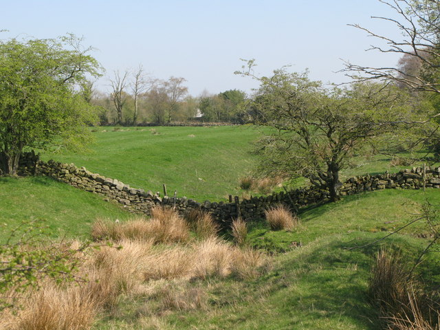
Milecastle 51 is situated 150m east of Wall Bowers and survives as a series of turf covered remains mostly on the south side of the modern road. The east and west walls survive as animal trampled robber trenches, 3m wide and with a maximum depth of 0.15m. The north wall is buried below the modern road. An outer ditch is discernible on the east side, curving around to the south side before fading. It survives up to 4.5m wide and 0.3m deep. It is at this milecastle that the Turf Wall and Stone Wall converge before continuing west on the same alignment. Excavations of the milecastle by Simpson in 1927 revealed the gateway and two stone barracks, one either side of the central space.
See our page: Milecastle 51
Scheduled Ancient Monument (#1010996): Hadrian's Wall and vallum between the field boundary west of Coombe Crag and Banks Green Cottage and the road to Lanercost at Banks in wall miles 51 and 52
Click the headings below to expand (selected extracts from the Historic England scheduling)
%
Hadrian's Wall survives mostly as a buried feature throughout this section except for short lengths of exposed Wall either side of the turrets and Pike Hill Tower. Where exposed the Wall measures 2.35m wide and up to 1.25m high. Elsewhere the Wall survives as a buried feature below the surface of the modern road or as a turf covered discontinuous robber trench east of turret 51a. Between turrets 51a and 51b the course of the Wall is overlain by the roadside wall.
The wall ditch survives as a well preserved earthwork visible on the ground throughout most of this section.
Turret 51a is situated 20m east of the stream known as Piper Sike. It survives as an upstanding stone feature visible on the ground. Its walls stand to a maximum height of 0.8m. Excavations were carried out in 1970 by Charlesworth who discovered the doorway in the east wall and a substantial platform against the north wall. Cooking hearths and rubbish were spread over the rest of the turret. Occupation did not continue later than the second century AD.
See our page: Turret 51a (Piper Sike)
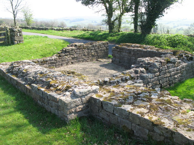
Turret 51b is situated 120m east of Leahill farm immediately to the north of the modern road. It survives as an upstanding stone feature. Its walls stand to a maximum height of 1.1m. Excavations in 1958 by Woodfield found that the turret measured 4.2m north to south by 4.5m across internally. The turret had been robbed though it still stood nine courses high. A platform was found in the centre of the north side and the doorway was in the east wall.
See our page: Turret 51b (Leahill)
The exact course of the Roman road known as the Military Way, which ran along the corridor between the Wall and the vallum linking the turrets, milecastles and forts, is known intermittently throughout this section where it survives as an earthwork feature. Opposite the disused quarry west of Bankshead Farm the Military Way survives as a terrace, 3m-5m wide, on the north side of an old hedge line. Occasional rises in hedgelines denote traces of its course.
The vallum survives intermittently as an upstanding earthwork visible on the ground throughout this section. It is best preserved at the east end of this section where the ditch averages 2.5m deep to the north, and the north and south mounds are nowhere more than 0.6m high. Elsewhere the vallum survives either as a ploughed down scarp up to 0.9m high and the ditch 0.8m deep, or there are no surface traces at all.
Leahill Turret 51b


from Geograph (geograph)
The north defensive ditch of Hadrian's Stone Wall east of Milecastle 51
Pinned by Simon Cotterill

from Geograph (geograph)
(The site of) Milecastle 51 (Wall Bowers) and the valley of Wall Burn
Pinned by Simon Cotterill


from Geograph (geograph)
The north defensive ditch of Hadrian's Wall east of Turret 51a (Piper Sike)
Pinned by Simon Cotterill


from https://historicengland.org.u…
Hadrian's Wall and vallum between the field boundaries east of milecastle 50 and the boundary west of Coombe Crag in wall miles 50 and 51
- ....Hadrian's Wall and vallum and their associated features between the field boundaries east of milecastle 50 and the field boundary west of Coombe Crag survive as a series of buried …
Added by
Simon Cotterill
from https://historicengland.org.u…
Hadrian's Wall and vallum between the field boundary west of Coombe Crag and Banks Green Cottage and the road to Lanercost at Banks in wall miles 51 and 52 - List Entry
- ....The monument includes the section of Hadrian's Wall and vallum and their associated features between the field boundary west of Coombe Crag in the east and Banks Green Cottage and …
Added by
Simon Cotterill

from https://perlineamvalli.wordpr…
Wall Mile 51
- Wall Mile 51 (December 4, 2011). Mike Bishop's PLV blog about walking Hadrian’s Wall written from an archaeologist’s point of view. "Our short diversion onto the road (which actually sits …
Added by
Simon Cotterill

from Geograph (geograph)
The north defensive ditch of Hadrian's Stone Wall east of Milecastle 51
Pinned by Simon Cotterill
from Geograph (geograph)
(The site of) Milecastle 51 (Wall Bowers) and the valley of Wall Burn
Pinned by Simon Cotterill
from Geograph (geograph)
The north defensive ditch of Hadrian's Wall east of Turret 51a (Piper Sike)
Pinned by Simon Cotterill
from https://historicengland.org.u…
Hadrian's Wall and vallum between the field boundaries east of milecastle 50 and the boundary west of Coombe Crag in wall miles 50 and 51
- ....Hadrian's Wall and vallum and their associated features between the field boundaries east of milecastle 50 and the field boundary west of Coombe Crag survive as a series of buried …
Added by
Simon Cotterill
from https://historicengland.org.u…
Hadrian's Wall and vallum between the field boundary west of Coombe Crag and Banks Green Cottage and the road to Lanercost at Banks in wall miles 51 and 52 - List Entry
- ....The monument includes the section of Hadrian's Wall and vallum and their associated features between the field boundary west of Coombe Crag in the east and Banks Green Cottage and …
Added by
Simon Cotterill
from https://perlineamvalli.wordpr…
Wall Mile 51
- Wall Mile 51 (December 4, 2011). Mike Bishop's PLV blog about walking Hadrian’s Wall written from an archaeologist’s point of view. "Our short diversion onto the road (which actually sits …
Added by
Simon Cotterill