Topics > Heritage Sites > Hadrian's Wall > Wall Mile 49
Wall Mile 49
Hadrian's Wall - Wall Mile 49
Hadrian's Wall stretches from the east to west coast of England and was an important frontier of the Roman Empire. Building of the wall began in AD 122 and took six years to complete it’s 84 mile (80 Roman mile) length. Soldiers were garrisoned along the line of the wall in large forts, smaller milecastles, and intervening turrets. The Vallum, a large ditch with mounds on either side, ran along the south side of the wall, protecting the rear of the frontier. Hadrian's Wall was designated as a World Heritage Site in 1987.
From Milecastle 49 to the western end of Hadrian's Wall on the Solway Firth, the wall was originally constructed from turf, possibly due to the absence of limestone. Subsequently, the turf wall was demolished and replaced with a stone wall.
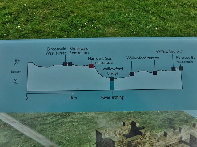
Wall Mile 49:
- Milecastle 49 (Harrows Scar) - significant visible remains
- Turret 49a - demolished when Birdoswald Fort was built
- Birdoswald Fort (Banna)
- Turret 49b (Birdoswald West)
Scheduled Monument (#1010994): Birdoswald Roman fort and the section of Hadrian's Wall and vallum between the River Irthing and the field boundaries east of milecastle 50
Click the headings below to expand (selected extracts from the Historic England scheduling)
%
In the original construction of Hadrian's Wall, the Wall west of the River Irthing was built as a turf rampart, probably due to a lack of building stone in the immediate vicinity. East of the Irthing the Wall was built from stone. However, by the end of the second century AD, the Turf Wall section was rebuilt in stone.
The Turf Wall ran from the milecastle at Harrow's Scar to the south side of the east gate of Birdoswald fort, continuing on the west side from the westgate. However, excavations in 1894 by the Cumberland Excavation Committee and in 1945 by Simpson and Richmond showed that the Turf Wall and its ditch were overlain by the fort. Its course has been confirmed by recent geophysical survey. The remains of the Wall survive as buried features with the only feature visible on the ground being the Turf Wall ditch west of the fort where it appears as a broad shallow depression occupied by a buried land drain.
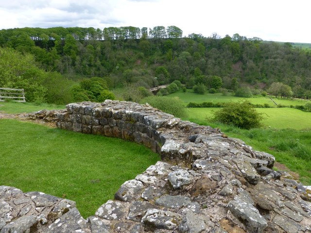
The Stone Wall survives very well in this section, being visible as an upstanding stone monument for most of this length. It averages 2.2m wide on abroad foundation 3m wide and averages over 1m high. There is an 874m stretch of the Wall which is consolidated and in the care of the Secretary of State in this section. In the section east of Birdoswald fort there are eight Roman inscribed stones in the south face of the Wall. The Wall where it coincided with the north wall of the fort has been largely levelled by the farm complex. Buried remains will survive below the farm area and road. At the west end of this section the remains of the Wall are buried below ground to the south of the modern road.
The wall ditch is visible in this section immediately to the north of the modern road which occupies the berm between the Wall and ditch. Here it averages 2m in depth. Towards the fort the ditch fades out due to silting; east of the fort the ditch is silted and marshy. Remains of the ditch upcast mound, usually referred to as the glacis, survive to the west of the fort as a low amorphous mound to the north of the wall ditch.
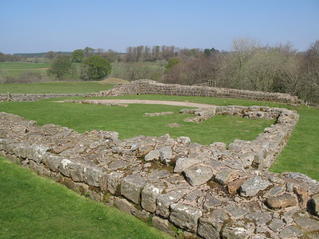
Milecastle 49 is situated on the west side of the Irthing gorge on the cliff known as Harrow's Scar. It survives as an upstanding stone feature. It is consolidated and in the care of the Secretary of State. It measures 23m north to south by 20m east to west. Excavations by Richmond took place in 1953 which revealed a gateway and the remains of the earlier phase turf milecastle below it which measured about 16.6m north to south by 15.4m east to west. The construction of a cottage, which probably dates to the 18th century, has destroyed much of the internal remains.
See our page: Milecastle 49 (Harrows Scar)
Turret 49a was situated on the line of the Turf Wall before Birdoswald fort was built, although it was itself made of stone, as were all the turrets. It was located by Simpson and Richmond during excavation in 1945. It was situated in the centre of Birdoswald fort below the Commandant's House. Its remains consisted of foundations only which survive buried below the fort remains.
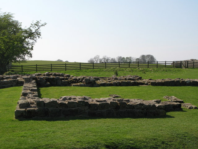
Turret 49b was situated on the line of the Turf Wall 350m west of the west gate of the fort at Birdoswald. It was located by Simpson, Richmond and St. Joseph during excavation in 1934, and was constructed in stone as were all the turrets. The excavators examined only the side walls in order to identify the position of the turret. The walls had been laid in a construction trench, and only the foundations remained. It is likely that the turret was demolished when the replacement Stone Wall was built to the north, and the stone from the Turf Wall turret used in its construction. The turret survives as a buried feature below the turf cover with no remains visible above ground.
Turret 49b, built for the Stone Wall, also survives as an upstanding stone feature and its walls have also been consolidated; it is in the care of the Secretary of State. Excavations in 1911 by Simpson showed there to be two early floor levels as well as late pottery demonstrating that the turret had continued in use, unlike many other turrets.
See our page: Turret 49b (Birdoswald West)
The course of the Roman road known as the Military Way, which ran along the corridor between the Wall and the vallum linking turrets, milecastles and forts, is known throughout this section. West of the fort it survives as an intermittent low linear mound, 0.1m in maximum height. East of the fort a geophysical survey in 1986 by Walker confirmed the existence of the Military Way below the turf cover.
The vallum survives as a buried feature for most of its course in this section. The only remains visible on the ground are to the south and west of turret 49b where the ditch is up to 2m deep, enhanced by a mole drain along its base. The ditch is also discernible as a depression, 0.4m deep, at the edge of the Irthing gorge. Excavation by Richmond from 1928 onwards showed that the vallum skirted the fort to the south. Richmond discovered a causeway across the vallum ditch which had vertical sides faced with ashlar and gaps showing where heavy masonry supporting an arched gateway over its centre had been before the structure was dismantled. The vallum seems to have been levelled here at the end of the Hadrianic period and wooden structures erected over its course.
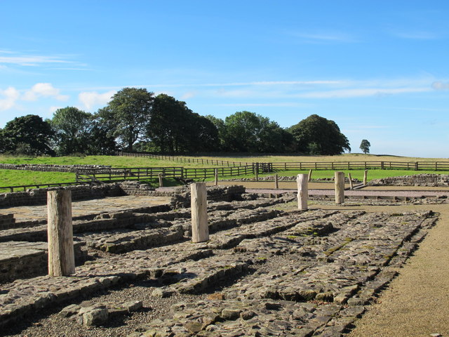
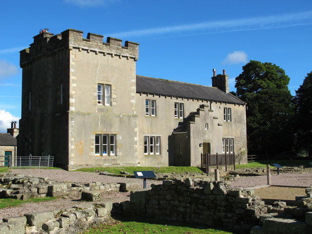
The fort at Birdoswald, known to the Romans as Banna, is situated on the gentle north facing slope of a ridge with a steep scarp to the south. It was located here to guard the bridging point of the Irthing 500m to the east. The walls of the fort are in the care of the Secretary of State. The fort measures 178.5m north to south by 123m east to west, enclosing an area of 2.2ha. It survives as a well preserved fort with walls and gateways standing as exposed features.
Farm buildings occupy the north west corner of the fort and the farm yards and the modern road have levelled the north curtain of the fort, which was also the main frontier Wall at this point. There has been a complex history of archaeological work on this site from the early 19th century through until the late 1980s. Buildings identified in the interior include the Commandant's House excavated in 1945 by Simpson and Richmond, the Commandant's Bath House excavated in 1850 by Potter, barrack blocks excavated by Richmond in 1928 and granaries, part of the west curtain and gate, together with the triple defence ditches by Wilmott in the late 1980s.
The stone revetted causeway across the ditch outside the west gateway is exposed as an upstanding feature. A unique feature of this fort is the remains of an ashlar structure made of very finely dressed stone on a chamfered plinth abutted by the west wall of the fort, adjacent to the west gate. A large Roman basilica was constructed in the north sector of the fort and was interpreted by Wilmott as a parade or drill hall. Wilmott also discovered an early medieval hall and associated structures constructed inside the fort over the earlier Roman remains, demonstrating continued use of the site in the post-Roman period. The area excavated by Wilmott to the south of the house has been consolidated by English Heritage.
To the south of the fort Richmond located and excavated a pair of parallel ditches which contained Housesteads Ware pottery and leather from a tented camp which predates the fort which was, truncated by the ditch of the vallum. The excavations in 1930 revealed a building 20ft square with three walls standing 13 courses high, identical in plan to a Turf Wall turret or a signal tower. The depth to which it was buried suggests that it may have been buried within the north mound of the vallum.
The fort was originally occupied by the first cohort of Dacians, 1000 strong, and probably early in the third century by the part- mounted first cohort of Thracians. Finds from the fort have included small hoards of denarii as well as altars, statuary and inscriptions. The conversion from the Turf Wall to the Stone Wall in this section involved a new line for the Stone Wall, which was brought up to the north angles of the fort. This created a larger space around the fort to the east and west. This space to the east of the fort may have contained the parade ground for the fort garrison. The parade ground at Birdoswald is attested by an impressive group of official parade ground dedications including over 20 to 'Jupiter Best and Greatest', however its exact position on the ground has not yet been confirmed.
In 1859 a delivery tank from an aqueduct was discovered near the centre of the fort together with an underground channel which was still delivering water from a point 277m west of the fort.
See our page: Birdoswald Roman Fort
A civil settlement outside the fort, usually known as a vicus, appears to have been located on the east side of the fort. Trenching in 1898 by Haverfield and in 1930 by Richmond to the east of the east gate of the fort showed evidence of some structures. Remains of buried features are visible on the ground as a series of scarps and stony banks up to 1m high. The concentration of stone in this area also implies the existence of buildings here.
A number of tombstones have been found reused in the fort testifying to an associated cemetery near the fort. The main cemetery may have been located to the west of the fort as the vicus was positioned on the east side and to the south is the steep scarp down to the Irthing. A number of Roman cremations in cinerary urns were discovered during deep ploughing in 1959 in New Field, north of Blackbank Wood. A childs' sarcophagus was also found but reburied. Furthermore a tombstone was found in this area to the west of the fort in 1961.
Milecastle 49 (Harrows Scar)


Co-Curate Page
Birdoswald Roman Fort (Banna)
- Overview Map Street View Hadrian's Wall Glossary Birdoswald Roman Fort (known as Banna) is situated on the western part of Hadrian's Wall, about 1 mile west of Gilsland in Cumbria. …


from Geograph (geograph)
Hadrian's Wall Path east of Milecastle 49 above the River Irthing
Pinned by Simon Cotterill


from https://historicengland.org.u…
Birdoswald Roman fort and the section of Hadrian's Wall and vallum between the River Irthing and the field boundaries east of milecastle 50 - List Entry
- ...The monument includes the Roman fort at Birdoswald and the section of
Hadrian's Wall and vallum and their associated features between the River
Irthing in the east and the field …
Added by
Simon Cotterill

from https://perlineamvalli.wordpr…
Wall Mile 49
- Wall Mile 49 (December 14, 2011). Mike Bishop's PLV blog about walking Hadrian’s Wall written from an archaeologist’s point of view. "...Regardless of whether we are following the Trail (which …
Added by
Simon Cotterill

Co-Curate Page
Birdoswald Roman Fort (Banna)
- Overview Map Street View Hadrian's Wall Glossary Birdoswald Roman Fort (known as Banna) is situated on the western part of Hadrian's Wall, about 1 mile west of Gilsland in Cumbria. …
from Geograph (geograph)
Hadrian's Wall Path east of Milecastle 49 above the River Irthing
Pinned by Simon Cotterill
from https://historicengland.org.u…
Birdoswald Roman fort and the section of Hadrian's Wall and vallum between the River Irthing and the field boundaries east of milecastle 50 - List Entry
- ...The monument includes the Roman fort at Birdoswald and the section of
Hadrian's Wall and vallum and their associated features between the River
Irthing in the east and the field …
Added by
Simon Cotterill
from https://perlineamvalli.wordpr…
Wall Mile 49
- Wall Mile 49 (December 14, 2011). Mike Bishop's PLV blog about walking Hadrian’s Wall written from an archaeologist’s point of view. "...Regardless of whether we are following the Trail (which …
Added by
Simon Cotterill


")
