Topics > Heritage Sites > Hadrian's Wall > Wall Mile 48
Wall Mile 48
Hadrian's Wall - Wall Mile 48
Hadrian's Wall stretches from the east to west coast of England and was an important frontier of the Roman Empire. Building of the wall began in AD 122 and took six years to complete it’s 84 mile (80 Roman mile) length. Soldiers were garrisoned along the line of the wall in large forts, smaller milecastles, and intervening turrets. The Vallum, a large ditch with mounds on either side, ran along the south side of the wall, protecting the rear of the frontier. Hadrian's Wall was designated as a World Heritage Site in 1987.
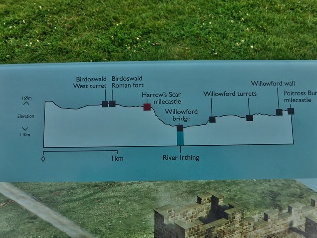
Wall Mile 48:
- Milecastle 48 (Poltross Burn)
- Turret 48a (Willowford East)
- Willowford Roman Bridge (over River Irthing) - significant remains of eastern abutment
- Turret 48b (Willowford West)
Scheduled Ancient Monument (#1015923): Hadrian's Wall and vallum and their associated features between Poltross Burn and the River Irthing in wall mile 48
Click the headings below to expand (selected extracts from the Historic England scheduling)
%
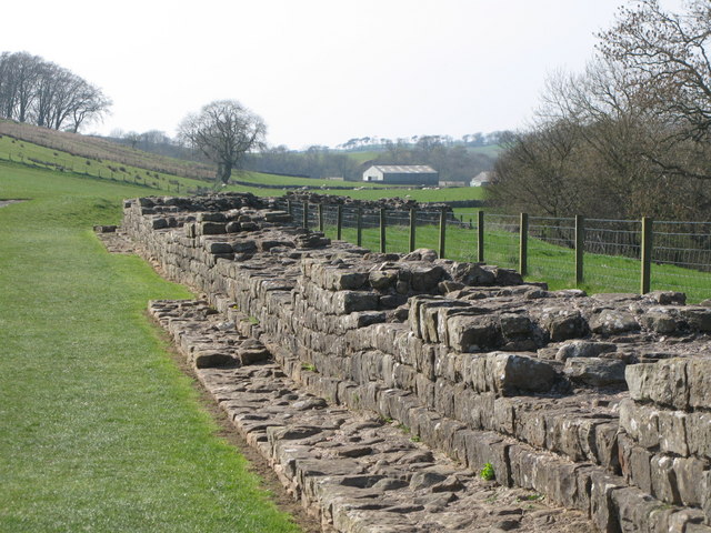
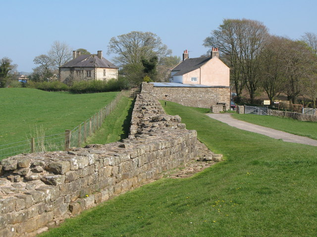
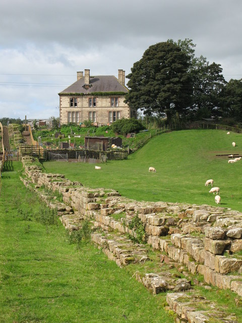
Hadrian's Wall survives as an upstanding feature throughout most of this section. All the upstanding sections of Wall are consolidated and in the care of the Secretary of State. The upstanding stretch of Wall from the railway embankment to Roman Way is also Listed Grade I. The Wall here is of narrow wall type, 2.2m wide, set on broad wall foundation, 3m wide. It stands to a maximum height of 2.8m west of turret 48b, but elsewhere averages 1.4m high.
The wall ditch also survives well as a feature visible on the ground in this section. Again the ditch is best preserved to the west of turret 48b where it has a maximum depth of 3.5m to the north and 1.7m to the south. Elsewhere the ditch averages 0.9m deep where extant. The ditch upcast mound, usually referred to as the glacis, survives as a broad low mound to the north of the ditch.
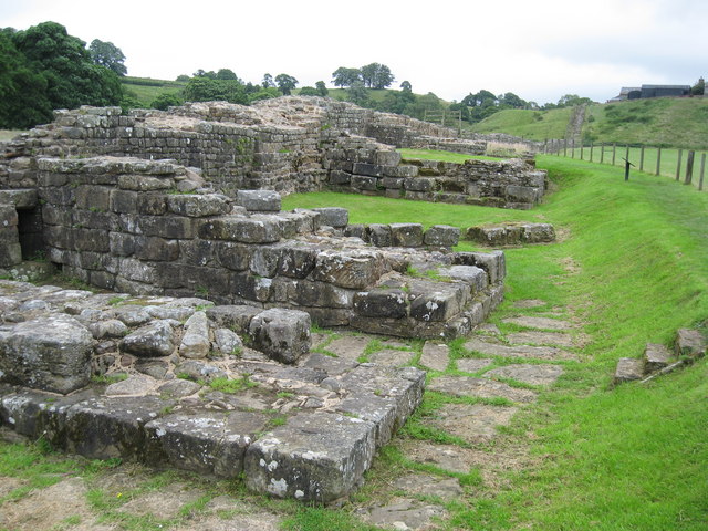
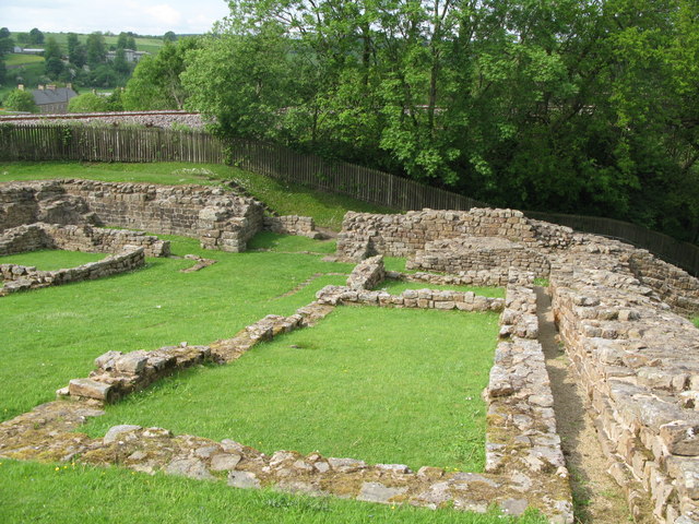
Milecastle 48, usually known as Poltross Burn milecastle, is situated on the crest of the west bank of a steep gorge through which the Poltross Burn flows. This well preserved milecastle survives as an upstanding monument and is in the care of the Secretary of State. Internally the milecastle measures 21.5m north to south by 18.7m across. Its walls were built to the broad gauge including its wing walls which extended 4m either side of the milecastle.
Excavations in 1909 by Gibson and Simpson found a number of features including the gateways. The lower courses of a flight of steps survive in the north east corner which suggest that the rampart walk would be 3.7m above ground with the battlements adding additional height to the overall height of the Wall. The remains of an oven are located in the north west angle. Long barrack blocks flanked the central space of the milecastle, both of which showed evidence of more than one phase of construction. Further excavations took place in 1965-6 by Charlesworth for the Ministry of Works.
See our page: Milecastle 48 (Poltross Burn)
Turret 48a is situated on a river terrace on the south bank of the River Irthing. It survives as an upstanding stone feature. It measures 4.15m across and the north wall stands 1.85m high. Excavations at the turret in 1923 by Shaw showed that the doorway was in the south west wall and several hearths and evidence of bronze and iron working were found in the interior.
See our page: Turret 48a (Willowford East)
Turret 48b is also situated on the south bank of the River Irthing immediately east of Willowford Farm. It too survives as an upstanding stone feature. This turret was also located and excavated in 1923 by Shaw.
See our page: Turret 48b Willowford West
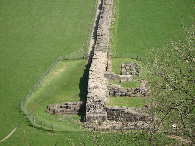
The foundations of the bridge abutment which carried Hadrian's Wall over the River Irthing are exposed on the east bank. It survives as a large upstanding stone feature. Excavations first took place in 1924 by Shaw, but more scientific excavations were carried out by Bidwell and Holbrook during 1984-5. A large tower and splayed abutment foundation represent the early phases of the original narrow bridge. However, the more massive projecting pier positioned further west represents the wider bridge of the later phase. This sequence of development is mirrored at the North Tyne crossing to the east of Chesters.
The stonework was bonded with dovetail cramps still visible in the outer stone pier of the original pair of narrow culverts. Sluices in the later pier are evidence of a water control system, possibly for an undershot water wheel. Excavations in 1940 by Simpson showed that the river once flowed immediately west of the abutment in a rocky gorge. The foundations of two further bridge piers were found, now 3m below the surface of the present river bank. The bridge abutment is in the care of the Secretary of State.
See our page: Willowford Roman Bridge
The course of the Roman road known as the Military Way, which ran along the corridor between the Wall and the vallum linking the turrets, milecastles and forts, is known with certainty in parts of this section. South of milecastle 48 it survives as a low linear causeway, 5m-6m wide and 0.3m high, for a distance of 45m. East of the milecastle it turns to the north east to descend the gorge at Poltross Burn. Trenching across the vallum by Simpson during 1910-12 showed that the Military Way ran along the north berm of the vallum between milecastle 48 to at least as far as Gilsland school. West of Gilsland school the course of the Military Way is not known precisely, though it is suggested by Holbrook and Bidwell that the modern farm track descending the river cliff may be on the line of the Roman road.
The vallum survives mostly as a buried feature throughout this section with few surface remains visible except around milecastle 48. The vallum ditch on the west side of the steep gorge of Poltross Burn was excavated by Simpson in 1910 where it was shown to be revetted with a stone wall here. Further trenching by Simpson between milecastle 48 and Gilsland school showed the ditch to be 6.2m wide and 1.54m deep below the ground surface.....


from Geograph (geograph)
The sluices in the eastern abutment of Willowford Bridge
Pinned by Simon Cotterill

from Geograph (geograph)
Hadrian's Wall east of Turret 48a (Willowford East) (2)
Pinned by Simon Cotterill
from Geograph (geograph)
Hadrian's Wall east of Turret 48a (Willowford East)
Pinned by Simon Cotterill

from https://historicengland.org.u…
Hadrian's Wall and vallum and their associated features between Poltross Burn and the River Irthing in wall mile 48 - List Entry
- ....The monument includes the section of Hadrian's Wall and vallum and their associated features between the Poltross Burn in the east and the River Irthing in the west. Hadrian's Wall …
Added by
Simon Cotterill


from Geograph (geograph)
The sluices in the eastern abutment of Willowford Bridge
Pinned by Simon Cotterill
from Geograph (geograph)
Hadrian's Wall east of Turret 48a (Willowford East) (2)
Pinned by Simon Cotterill
from Geograph (geograph)
Hadrian's Wall east of Turret 48a (Willowford East)
Pinned by Simon Cotterill
from https://historicengland.org.u…
Hadrian's Wall and vallum and their associated features between Poltross Burn and the River Irthing in wall mile 48 - List Entry
- ....The monument includes the section of Hadrian's Wall and vallum and their associated features between the Poltross Burn in the east and the River Irthing in the west. Hadrian's Wall …
Added by
Simon Cotterill


")
