Topics > Heritage Sites > Hadrian's Wall > Wall Mile 45
Wall Mile 45
Hadrian's Wall - Wall Mile 45
Hadrian's Wall stretches from the east to west coast of England and was an important frontier of the Roman Empire. Building of the wall began in AD 122 and took six years to complete it’s 84 mile (80 Roman mile) length. Soldiers were garrisoned along the line of the wall in large forts, smaller milecastles, and intervening turrets. The Vallum, a large ditch with mounds on either side, ran along the south side of the wall, protecting the rear of the frontier. Hadrian's Wall was designated as a World Heritage Site in 1987.
Wall Mile 45:
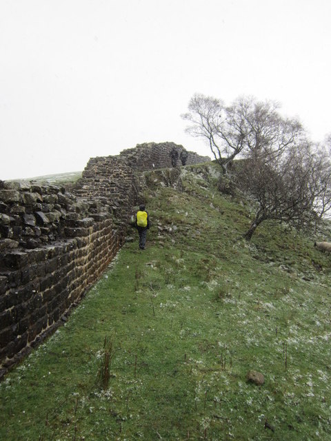
This section of the wall is well preserved and is on the Pennine Way and Hadrian Wall Path. Turret 45a is located just under half a mile north-east of the visitor centre at Walltown Country Park. Turrent 45b was destroyed by quarrying in the late 19th century.
- Milecastle 45 (Walltown) - visible as eartheworks
- Turret 45a (Walltown) - significant visible remains
- Turret 45b (Walltown West) - destroyed by quarrying, no visible remains
Scheduled Monument (#1017535): Hadrian's Wall between the track to Cockmount Hill and Walltown Quarry East in wall miles 43, 44 and 45
Click the headings below to expand (selected extracts from the Historic England scheduling)
%
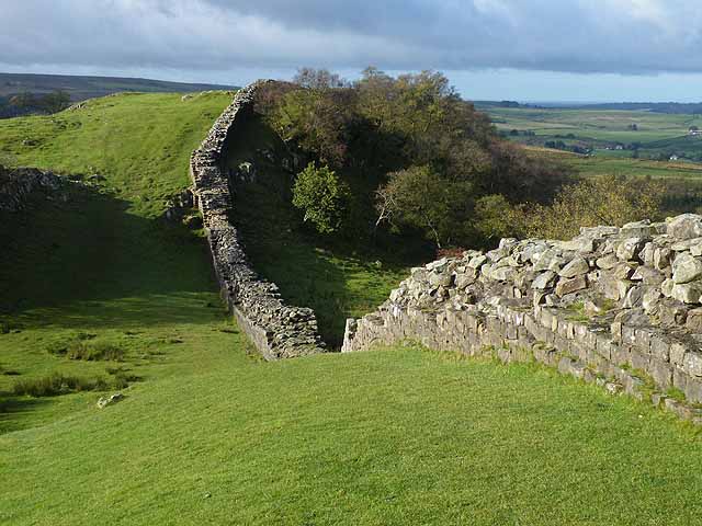
Hadrian's Wall survives mostly as a low stony rubble and turf covered mound throughout this section averaging 5m wide and 1m high, except for a few stretches of exposed upstanding masonry. At Cockmount Hill buildings overlie the line of the Wall. Between Cockmount Hill and milecastle 44 a modern field wall overlies the north face of the Wall where Hadrian's Wall survives up to a maximum height of 1.7m. Here the south face is hidden below wall debris and is up to 1.3m high. West of Cockmount Hill a 50m stretch of unconsolidated Wall is exposed, up to 1.1m in height. West of milecastle 44 there are two sections of exposed Wall, 2.25m wide and standing 0.8m high. A short section of unconsolidated exposed Wall in a state of collapse is situated to the west of milecastle 45.
The Wall ditch seems to have been only partly completed west of Cockmount Hill before its full construction was abandoned. It is best preserved west of turret 43b where it has a depth of 2.2m with traces of the upcast mound, usually referred to as the glacis, on its north side. Along Walltown Crags the building of a ditch was unnecessary, except in the `nicks' or gaps which break up the crags. The section north of `King Arthur's Well' survives up to 2m deep with the glacis 0.7m high to the north. Two shallower sections of ditch are visible in the two nicks to the east.
Milecastle 45 is situated on the crest of Walltown Crags with commanding views to the north and south. This milecastle survives as a turf covered feature. The walls are indicated by the remains of robber trenches flanked by spoil heaps. Large dressed stones from the gateway have been built into the low wall to the rear of the cattle trough east of Walltown farm.
The course of the Roman road known as the Military Way, which ran along the corridor between the Wall and the vallum linking the turrets, milecastles and forts, is known throughout the length of this section. It survives as a low turf covered causeway 5.5m wide and up to 0.5m high, or as a terrace in the hillside with a minimum width of 3m. It is straight for most of its course except where it deviates around rock outcrops. West of the Cockmount Hill Plantation the foundations of two large regularly laid out rectangular buildings overlie the Military Way, using it as a hard standing. Their form suggests they are post-medieval or later in date.
South east of King Arthur's Well a spur road branched off the Military Way, the remains of which can be seen as a turf covered causeway leading south east towards Lowtown.
An uninscribed Roman milestone is located along the line of the Wall west of Cockmount Hill. It forms the west post of the field gate at the west end of Cockmount Hill Wood.
There is a series of five cultivation terraces on the slope to the south of Cockmount Hill Wood. They survive as turf covered earthworks. These cultivation remains run parallel with the contours on a south facing slope like the cultivation terraces at Housesteads which have been confirmed to be Roman. Later narrow ridge and furrow, on average 2.5m apart, overlies some of these earlier terraces.
Scheduled Monument (#1010977): Hadrian's Wall between Walltown Quarry East and Walltown Quarry West in wall mile 45
Click the headings below to expand (selected extracts from the Historic England scheduling)
%
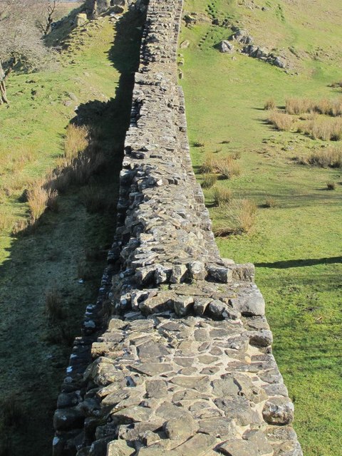
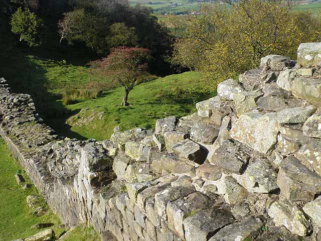
Hadrian's Wall follows the crest of Walltown Crags in this section with commanding views in all directions. It survives well as an upstanding feature, a 410m section being consolidated and in the care of the Secretary of State. It stands to a maximum height of 2.2m. A number of inscribed stones, indicating which section of the Roman army built this stretch, were found fallen from the south face of the Wall during conservation work in 1960. The short stretch of Wall not exposed east of turret 45a survives as a low amorphous stony bank, 0.3m high.
Turret 45a is situated on a high point on Walltown Crags with extensive views in all directions. It survives as an upstanding exposed feature, which is consolidated and in the care of the Secretary of State. The interior of the turret was investigated in 1883 and partly excavated in 1913. Further excavations in 1959 by Woodfield showed that it had originally been built as a free standing tower and was then later incorporated into the Wall line as a turret. It has a doorway in the south east side.
See our page: Turret 45a (Walltown)
Turret 45b was situated further west along the Nine Nicks of Thirlwall, but it has been completely destroyed by Walltown Quarry West which has removed the line of the crags in this area. Consequently this area is not included in the scheduling as no archaeological remains survive here. Excavations in 1883 prior to the destruction of the turret showed that it measured 3.95m north to south by 4.25m across internally. The walls were 1m thick and between 1m and 2m high.
The course of the Roman road known as the Military Way, which ran along the corridor between the Wall and the vallum linking the turrets, milecastles and forts, is known throughout this section. It is visible as a low causeway, 0.2m high, or as a terrace, 5m wide, winding between rock outcrops to the south of the Wall.
Scheduled Monument (#1010978) The vallum between Cockmount Hill and Walltown Quarry West in wall miles 43, 44 and 45
Click the headings below to expand (selected extracts from the Historic England scheduling)
%
For most of its length the vallum survives as an upstanding earthwork. However, south of Allolee where its remains are not generally visible above ground, traces have recently been identified by the Royal Commision on the Historical Monuments of England. The presumed course as shown on Ordnance Survey maps is thus now known to be incorrect. The scheduling respects the new known alignment here.
Where it survives as an earthwork the vallum ditch averages 1m deep with a maximum depth of 2.7m in places. The north mound averages 0.8m high and the south mound 0.4m. Good examples of crossing points positioned at 37m intervals are visible throughout this section....The area of vallum within Walltown Woods is situated on a spring line with drainage channels cut across the banks. Otherwise it survives well in the woodland.
Scheduled Monument (#1010991): Carvoran Roman fort and Hadrian's Wall and vallum between the unclassified road to Old Shield and the field boundary west of the fort in wall miles 45 and 46
Click the headings below to expand (selected extracts from the Historic England scheduling)
Hadrian's Wall survives as a buried feature throughout this short section. It is traced on the ground as a robber trench, seen as a depression in the turf cover, 2m wide. West of milecastle 46 the Wall remains survive as a low turf-covered stony mound, 0.3m high.
The wall ditch survives very well as a turf-covered earthwork visible on the ground. It averages over 3m in depth throughout its length in this section. The ditch upcast mound, known as the glacis, to the north of the ditch also survives well in this section. It is visible on the ground as a substantial low mound, up to 10m wide in places.
Listed Building, Grade I (#1155916): Milecastles 43, 44, 45 and 46; turrets 42B, 43A, 43B, 44A, 44B, 45A and 45B


from https://historicengland.org.u…
Hadrian's Wall between the track to Cockmount Hill and Walltown Quarry East in wall miles 43, 44 and 45 - List Entry
- ....The monument includes the section of Hadrian's Wall and its associated features between the track to Cockmount Hill in the east and Walltown Quarry East in the west. All upstanding …
Added by
Simon Cotterill
from https://historicengland.org.u…
Hadrians Wall, Milecastles and Turrets, B6318 - List Entry
- Hadrian's wall; milecastles 43, 44, 45 and 46; turrets 42B, 43A, 43B, 44A, 44B, 45A and 45B. AD 122, reconstructed AD 205. Rubble core with dressed stone faces. Course of …
Added by
Simon Cotterill
from https://historicengland.org.u…
The vallum between Cockmount Hill and Walltown Quarry West in wall miles 43, 44 and 45 - List Entry
- .....the section of vallum between Cockmount Hill in the east and the west side of Walltown Wood in the west. For most of its length the vallum survives as an …
Added by
Simon Cotterill


from Geograph (geograph)
Hadrian's Wall above the (disused) quarry near Walltown
Pinned by Simon Cotterill


from https://historicengland.org.u…
Carvoran Roman fort and Hadrian's Wall and vallum between the unclassified road to Old Shield and the field boundary west of the fort in wall miles 45 and 46 - List Entry
- .....The monument includes the Roman fort at Carvoran and Hadrian's Wall and vallum and their associated features between the road to Old Shield in the east and the field boundary …
Added by
Simon Cotterill
from https://historicengland.org.u…
Hadrian's Wall between Walltown Quarry East and Walltown Quarry West in wall mile 45 - List Entry
- ....The monument includes the section of Hadrian's Wall and its associated features between the two quarries at Walltown in wall mile 45. All the upstanding remains of Hadrian's Wall and …
Added by
Simon Cotterill

from https://historicengland.org.u…
Hadrian's Wall between the track to Cockmount Hill and Walltown Quarry East in wall miles 43, 44 and 45 - List Entry
- ....The monument includes the section of Hadrian's Wall and its associated features between the track to Cockmount Hill in the east and Walltown Quarry East in the west. All upstanding …
Added by
Simon Cotterill
from https://historicengland.org.u…
Hadrians Wall, Milecastles and Turrets, B6318 - List Entry
- Hadrian's wall; milecastles 43, 44, 45 and 46; turrets 42B, 43A, 43B, 44A, 44B, 45A and 45B. AD 122, reconstructed AD 205. Rubble core with dressed stone faces. Course of …
Added by
Simon Cotterill
from https://historicengland.org.u…
The vallum between Cockmount Hill and Walltown Quarry West in wall miles 43, 44 and 45 - List Entry
- .....the section of vallum between Cockmount Hill in the east and the west side of Walltown Wood in the west. For most of its length the vallum survives as an …
Added by
Simon Cotterill
from Geograph (geograph)
Hadrian's Wall above the (disused) quarry near Walltown
Pinned by Simon Cotterill
from https://historicengland.org.u…
Carvoran Roman fort and Hadrian's Wall and vallum between the unclassified road to Old Shield and the field boundary west of the fort in wall miles 45 and 46 - List Entry
- .....The monument includes the Roman fort at Carvoran and Hadrian's Wall and vallum and their associated features between the road to Old Shield in the east and the field boundary …
Added by
Simon Cotterill
from https://historicengland.org.u…
Hadrian's Wall between Walltown Quarry East and Walltown Quarry West in wall mile 45 - List Entry
- ....The monument includes the section of Hadrian's Wall and its associated features between the two quarries at Walltown in wall mile 45. All the upstanding remains of Hadrian's Wall and …
Added by
Simon Cotterill


")

