Topics > Heritage Sites > Hadrian's Wall > Wall Mile 35
Wall Mile 35
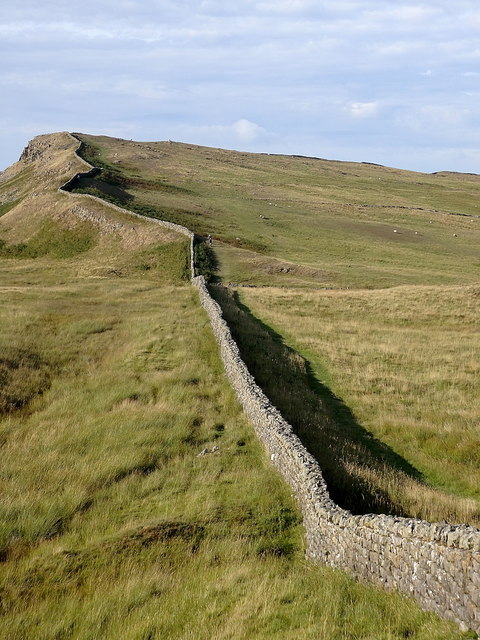
Hadrian's Wall - Wall Mile 35
Hadrian's Wall stretches from the east to west coast of England and was an important frontier of the Roman Empire. Building of the wall began in AD 122 and took six years to complete it’s 84 mile (80 Roman mile) length. Soldiers were garrisoned along the line of the wall in large forts, smaller milecastles, and intervening turrets. The Vallum, a large ditch with mounds on either side, ran along the south side of the wall, protecting the rear of the frontier. Hadrian's Wall was designated as a World Heritage Site in 1987.
Wall Mile 35:
- Milecastle 35 (Sewingshields) - significant visible remains
- Turret 35a (Sewingshields Crag) - significant visible remains
- Turret 35b (Busy Gap) - no visible surface remains
Milecastle 35 is located west of Sewingshields Farm, where the farm house was built using stone from Hadrian's Wall
Scheduled Monument (#1010964): Hadrian's Wall and associated features between the boundary east of turret 34a and the field boundary west of milecastle 36 in wall miles 34, 35 and 36
Click the headings below to expand (selected extracts from the Historic England scheduling)
Map showing the Scheduled Monument area (Historic England data), with additional markers.
%
The Wall survives intermittently as an upstanding feature throughout this section. West of milecastle 35 the Wall survives as an irregular turf-covered mound, averaging 2.5m wide and 0.6m high. Either side of milecastle 35 the remains of the Wall are upstanding and have been consolidated. At 2.3m wide it is of narrow wall type, though it has been set on a broad wall foundation, 3m wide. It stands to a maximum height of 1.5m. Along the crest of Sewingshields Crags the upstanding sections of consolidated Wall are divided by sections of the Wall which survive as turf-covered mounds, averaging 2.5m wide and 1m high.
Milecastle 35 is located on the east facing slope of Sewingshields Crags. It survives as an upstanding masonry feature which has been consolidated and is now in the care of the Secretary of State. It measures 18.3m north-south by 15.2m east-west. The walls are up to 3.2m in width. Within the milecastle several phases of buildings are preserved in the ground plan.
See our page: Milecastle 35 including further details and photos.
Turret 35a is located on the summit of Sewingshields Crags. It survives as an upstanding feature. The masonry has been consolidated and it is in the care of the Secretary of State. The turret was located in 1913. Excavations took place during 1947 and 1958 when it was found to have narrow walls, 1m wide, and a door in the east side, 0.95m wide. The turret was shown to have been abandoned during the Roman period, though it is not certain when. Its internal measurements are 3.7m east-west by 2.4m north-south; the walls are up to 0.75m high.
See our page: Turret 35a with further details and photos.
Turret 35b is located to the north of Busy Gap on the west facing slope of Sewingshields Crags. It survives as a slight turf-covered platform measuring 5.5m from north west to south east by 5.5m north east to south west. Its interior is partly overlain by stone which has tumbled onto it from the adjacent Wall. The turret was located during 1913. Part excavation during 1946 showed that the turret had narrow walls and a door in the east side.
The course of the Roman road known as the Military Way, which ran along the corridor between the Wall and the vallum linking turrets, milecastles and forts survives as a turf-covered linear mound throughout most of this section. It is visible as a disturbed causeway averaging 5m wide with traces of a stone revetment on the south side. It was partly excavated between 1978 and 1980 when it was shown to have a damaged metalled surface 4m wide, a stone revetment on the south scarp, and to have been overlain by later roadways.
Branch roads survive linking the Military Way with the south gates of both milecastles 35 and 36. At milecastle 35 the low, uneven turf-covered mound of the causeway is up to 5.5m wide and 0.2m high.
On the north west side of Busy Gap there are the remains of a triangular shaped enclosure, known as the King's Wicket. It survives as a series of earthworks which include a turf-covered inner mound and traces of an external silted ditch. The enclosure is known to be a later feature which used the Wall line as its east side. It is considered to be early medieval in date and it has been interpreted as a drovers' stock compound, possibly as a gathering point for sheltering stock when they were being driven off the common land and down to the lower pastures.
Scheduled Monument (#1010965): The vallum and early Roman road between the field boundary east of turret 34a and the field boundary west of milecastle 36 in wall miles 34, 35 and 36
Click the headings below to expand (selected extracts from the Historic England scheduling)
%
The vallum survives as a series of upstanding earthworks throughout this section. The north mound of the vallum has been reduced by pasture improvement, though it still averages 1m in height. A number of low points in the mound throughout its course denote crossings over the vallum. The south mound averages about 1.2m in height, but in places it is overlain and partly obliterated by a modern field wall. The vallum ditch is well preserved, averaging 2m in depth.
The causeway of an early Roman road is located running parallel to the vallum on its north side opposite Moss Kennels. It is visible as a turf-covered mound....
Listed Buildfing, Grade I (#1045249): Hadrian's wall, Milecastles and Turrets
Includes Hadrian's wall; milecastles 30, 31, 34 and 35; turrets 29B, 30A, 30B, 33B, 34A and 35A.


from https://historicengland.org.u…
HADRIANS WALL, MILCASTLES AND TURRETS - List Entry
- "Hadrian's wall; milecastles 30, 31, 34 and 35; turrets 29B, 30A, 30B, 33B, 34A and 35A. AD 122, reconstructed AD 205. Rubble core with dressed stone faces. Course of wall …
Added by
Simon Cotterill


from https://historicengland.org.u…
Hadrian's Wall and associated features between the boundary east of turret 34a and the field boundary west of milecastle 36 in wall miles 34, 35 and 36
- ....The monument includes the section of Hadrian's Wall and its associated features between the field boundary east of turret 34a in the east and the field boundary west of milecastle …
Added by
Simon Cotterill
from https://historicengland.org.u…
The vallum and early Roman road between the field boundary east of turret 34a and the field boundary west of milecastle 36 in wall miles 34, 35 and 36 - List Entry
- ....The vallum and its associated features including the Roman road between the field boundary east of turret 34a and the field boundary west of milecastle 36 survive well as a …
Added by
Simon Cotterill


from https://historicengland.org.u…
HADRIANS WALL, MILCASTLES AND TURRETS - List Entry
- "Hadrian's wall; milecastles 30, 31, 34 and 35; turrets 29B, 30A, 30B, 33B, 34A and 35A. AD 122, reconstructed AD 205. Rubble core with dressed stone faces. Course of wall …
Added by
Simon Cotterill
from https://historicengland.org.u…
Hadrian's Wall and associated features between the boundary east of turret 34a and the field boundary west of milecastle 36 in wall miles 34, 35 and 36
- ....The monument includes the section of Hadrian's Wall and its associated features between the field boundary east of turret 34a in the east and the field boundary west of milecastle …
Added by
Simon Cotterill
from https://historicengland.org.u…
The vallum and early Roman road between the field boundary east of turret 34a and the field boundary west of milecastle 36 in wall miles 34, 35 and 36 - List Entry
- ....The vallum and its associated features including the Roman road between the field boundary east of turret 34a and the field boundary west of milecastle 36 survive well as a …
Added by
Simon Cotterill


