Topics > Heritage Sites > Hadrian's Wall > Wall Mile 31
Wall Mile 31
Hadrian's Wall - Wall Mile 31
Hadrian's Wall stretches from the east to west coast of England and was an important frontier of the Roman Empire. Building of the wall began in AD 122 and took six years to complete it’s 84 mile (80 Roman mile) length. Soldiers were garrisoned along the line of the wall in large forts, smaller milecastles, and intervening turrets. The Vallum, a large ditch with mounds on either side, ran along the south side of the wall, protecting the rear of the frontier. Hadrian's Wall was designated as a World Heritage Site in 1987.
Wall Mile 31:
- Milecastle 31 (Carrawburgh)
- Turret 31a (The Strands)
- Turret 31b (Carraw East)
- Carrawburgh Roman Fort (Brocolitia) (fort)
- Temple of Mithras
- Coventinas Well
Scheduled Monument (#101096): Hadrian's Wall and vallum between the road to Simonburn and the field boundary east of Carrawburgh car park in wall miles 29, 30 and 31
Click the headings below to expand (selected extracts from the Historic England scheduling)
Map showing the Scheduled Monument area (Historic England data).
%
The monument includes the section of Hadrian's Wall and associated features between the minor road to Simonburn in the east and the field boundary to the east of Carrawburgh car park in the west. This section of the Wall follows an alignment straight from the North Tyne to the high point at Limestone Corner where it changes to a more westerly direction and occupies the gentle west facing slope all the way to Carrawburgh. There are good views to the north and south all along this section, and in particular from Limestone Corner. All the upstanding remains of Hadrian's Wall, the milecastles and turrets in this scheduling are Listed Grade I. The Wall survives as a buried feature for most of this section, except for the two well preserved sections west of the minor road to Simonburn.
Milecastle 31 is situated immediately to the east of Carrawburgh car park with wide views to the north and south, but with a restricted outlook to the east and west. It survives as a low turf covered platform 0.25m high. The remains of north wall of the milecastle lies beneath the B6318 road. Traces of the road connecting the milecastle to the Military Way survive as a causeway 0.15m high.
Scheduled Monument (#1015914): Carrawburgh Roman fort and Hadrian's Wall and vallum between the field boundary east of the fort and the field boundary west of Coventina's Well in wall mile 31
Click the headings below to expand (selected extracts from the Historic England scheduling)
Map showing Scheduled Munument area (Historic England data), with additional markers.
%
The monument includes the Roman fort at Carrawburgh and the section of Hadrian's Wall between the field boundary east of Carrawburgh car park in the east and the field boundary west of Coventina's Well in the west. The upstanding remains of Hadrian's Wall from the field boundary east of the fort to the road junction west of Coventina's Well are Listed Grade I.
This section of Wall is situated in the shallow dip occupied by Meggie's Dene Burn. The Wall survives below the course of the B6318 road throughout this section.
The wall ditch survives well as a visible earthwork on the north side of the road. It averages about 1m deep, though it attains a maximum depth of 3m in places. The upcast from the ditch, otherwise known as the glacis, survives well in this section as a broad low mound to the north of the ditch.
The precise location of turret 31a has not yet been confirmed as there are no upstanding remains visible above ground. However, on the basis of the usual spacing it is expected to be located about 270m west of Carrawburgh fort, beneath the surface of the B6318 road.
The course of the Roman road known as the Military Way, which ran along the corridor between the Wall and vallum linking the turrets, milecastles and forts, is known for part of this section. It is visible as a low turf covered causeway immediately south of the car park heading directly for the east gate of the fort, though it fades before it reaches the fort. On the west side of the fort it re-emerges heading from the west gateway to the north mound of the vallum which was used to carry the road in this section. The road is visible as a low linear mound, 0.2m high, along the summit of the north mound of the vallum.
The vallum survives as an intermittent earthwork throughout this section. The vallum predates the fort at Carrawburgh as it was levelled to make way for the fort leaving no surface trace of the vallum in this area. To the west of the fort the vallum survives as a series of earthworks which have been reduced by later cultivation. The ditch averages 0.8m in depth, while the north mound of the vallum is visible as a low mound.
The fort at Carrawburgh, known to the Romans as Brocolitia, occupies a slight terrace on an otherwise gentle east facing slope, 650m west of the modern farm of Carrawbrough. The fields to the south and east of the fort are in the care of the Secretary of State. The fort is well preserved below the turf cover and its walls are believed to stand to around 1.5m in height. It measures 139.5m north-south by 109m east-west and encloses an area of 1.4ha. The defences consisted of a wall, 1.7m thick, backed by an earthen rampart with at least two external ditches in its earlier phases. Excavation of the headquarters building showed that the vallum had been levelled and its ditch filled in and the fort placed on top, demonstrating that the fort was added to the frontier system after the Wall and vallum had been constructed. The fort was built for a cohort 500 strong, possibly part mounted.
See our page: Brocolitia Roman Fort
The civil settlement, or vicus, is located outside the fort to the south and west. It survives well as a series of earthworks and buried features. On the west side of the fort six terraces with scarps up to 2.1m high have been cut into the slope, parallel with the wall of the fort. Like the interior buildings of the fort, the stone buildings in the vicus have suffered from stone robbing.
A bath house was discovered outside the fort and was excavated by Tailford on behalf of John Clayton during the 1870s. It had a layout similar to the Chesters bath house, though it was smaller in size. The excavation report indicates that it was radically reconstructed, probably during the fourth century AD. The location of the baths was not recorded in detail and so now its position is not known with certainty. However, a platform to the south of the fort has been scooped out of a terrace close to the water level of the burn. The measurements of the bath house as excavated by Tailford would fit exactly into these earthworks. A paved road, 3.5m wide, was located in 1977 leading up to this platform from the burn.
A shrine to a water-goddess known as Coventina was located and excavated by Tailford in the late 1870s. It was situated to the west of the fort at the source of a spring. The spring was encased in a rectangular stone basin about 2.6m by 2.4m. This basin was located at the centre of a walled enclosure, or temple, measuring 12.2m north-south by 11.6m east-west. A well, 2.1m deep and lined with masonry, is situated in the shrine. When excavated its contents included at least 13,487 coins, ten altars, a relief of three water-nymphs, the head of a male statue, two dedication slabs to the goddess Coventina, two clay incense burners and a wide range of votive offerings. Coventina's Well can be seen enclosed by a fence to the west of the field wall on the west side of the fort.
See our page: Coventinas Well
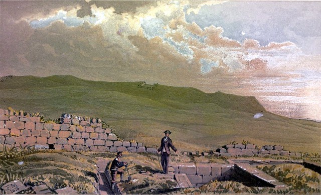
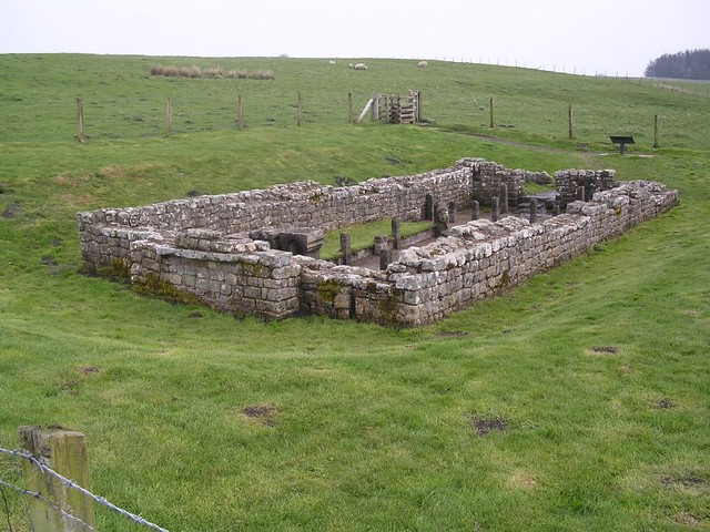
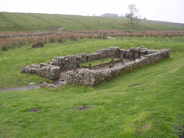
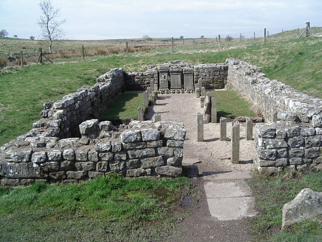
A temple to the god Mithras, more commonly known as a Mithraeum, was discovered during the dry summer of 1949. It was excavated in the following year by Richmond and Gillam. It has since been consolidated and is now displayed in its fourth century AD form, using cement replicas of the altars and statuettes and representations of interwoven timber wattle. It survives well as an upstanding stone structure, and is in the care of the Secretary of State. The original altars and statuettes form part of a full size reconstruction of the temple located in the Museum of Antiquities at Newcastle Upon Tyne. When the Mithraeum was excavated Roman timbers were discovered in- situ due to the waterlogged conditions. Five phases of construction were able to be identified in the well preserved remains. Immediately outside the door of the Mithraeum was a small shrine now known as the `Temple of the Nymphs'. This feature was excavated during 1960 by Smith. Its remains included an altar, a spring/well, a paved area and an apsidal structure with a bench and short wing walls. This small temple was open to the sky. There are no upstanding remains visible on the surface except for the top of the north slab of the well-head.
See our page: Temple of Mithras
A cemetery is known to be situated on the east side of the fort. Lingard noted in 1807 that bones had been found between the fort and milecastle 31. Ten years later Hodgson learnt that urned cremations had been found during the quarrying to the east of the fort. Five tombstones have been recovered from Carrawburgh though their original positions are unknown. Excavations during 1964, in advance of the construction of the car park, revealed fragmentary remains of two buildings, one of which was identified as a small temple or funerary monument.
Scheduled Monument (1010962): Hadrian's Wall and vallum between the field boundary west of Coventina's Well and the field boundary at Brown Dikes in wall miles 31 and 32
Click the headings below to expand (selected extracts from the Historic England scheduling)
Map showing the Scheduled Monument area (Historic England data).
%
The monument includes the section of Hadrian's Wall, vallum and their associated features between the field boundary west of Coventina's Well in the east and the field boundary at Brown Dikes in the west. This section occupies a gentle east facing slope with wide views to the north and south.
Hadrian's Wall survives as a buried feature throughout this section. East of Carraw Farm it is overlain by the modern field wall which defines the south side of the B6318 road. Here its line is visible as a disturbed grassy bank, 0.4m high, at the base of the modern wall. West of Carraw Farm its line is visible as a well defined robber trench, about 2m wide, beyond which it reappears as a slight scarp below the field wall which defines the south side of the road. West of here the Wall is overlain by the modern B6318 road.
At Carraw Farm the survival of the remains of the Wall and wall ditch have not been confirmed. To the east and west of Carraw Farm the wall ditch is partly encroached on by the B6318 road. However, it is visible to an average depth of 1.5m. The wall ditch is best preserved at the west end of this section where it reaches a depth of 3m. The upcast from the ditch, known as the glacis, survives intermittently as a mound to the north of the ditch. It is also best preserved at the west end of this section where it averages 1.4m in height.
Turret 31b is visible as a slight mound about 80m to the east of Carraw Farm. Its doorway was in the east side. Its remains are buried below the turf cover slightly to the south of the B6318 road.
The course of the Roman road known as the Military Way, which ran along the corridor linking turrets, milecastles and forts is not yet known with certainty in this section. However, there is a slight rise alongside the field wall on the south side of the wooded area to the south of Carraw Farm which could be the remains of the `agger', or raised spine, of the road. The antiquarian Horsley, writing in the 1730s, stated that the Military Way was carried on the north mound of the vallum in this general area.
The vallum is visible intermittently as an upstanding earthwork throughout this section. It is least well preserved at the east end where only the ditch is visible, having an average depth of 2m. West of milecastle 32 the earthworks are better preserved. The north mound is in good condition, reaching 1.5m in height, while the south mound at best reaches 0.9m. Here the ditch is waterlogged and silted, though it averages a depth of 1m.
Listed Building, Grade I (#1045249): Hadrian's wall, Milecastles and Turrets
Includes Hadrian's wall; milecastles 30, 31, 34 and 35; turrets 29B, 30A, 30B, 33B, 34A and 35A.


from https://historicengland.org.u…
HADRIANS WALL, MILCASTLES AND TURRETS - List Entry
- "Hadrian's wall; milecastles 30, 31, 34 and 35; turrets 29B, 30A, 30B, 33B, 34A and 35A. AD 122, reconstructed AD 205. Rubble core with dressed stone faces. Course of wall …
Added by
Simon Cotterill
from https://historicengland.org.u…
Hadrian's Wall and vallum between the field boundary west of Coventina's Well and the field boundary at Brown Dikes in wall miles 31 and 32 - List Entry
- ....Hadrian's Wall and vallum and their associated features between the field boundary west of Coventina's Well and the field boundary at Brown Dikes survive well as a series of buried …
Added by
Simon Cotterill
from https://historicengland.org.u…
Carrawburgh Roman fort and Hadrian's Wall and vallum between the field boundary east of the fort and the field boundary west of Coventina's Well in wall mile 31 - List Entry
- ...The wall fort at Carrawburgh and its associated section of Hadrian's Wall and associated features survives well as a series of turf covered and upstanding stone remains. It is one …
Added by
Simon Cotterill
from https://historicengland.org.u…
Hadrian's Wall and vallum between the road to Simonburn and the field boundary east of Carrawburgh car park in wall miles 29, 30 and 31 - List Entry
- ...Hadrian's Wall and its associated works between the minor road to Simonburn and the field boundary east of Carrawburgh car park survive well as upstanding and buried features for most …
Added by
Simon Cotterill

from https://historicengland.org.u…
HADRIANS WALL, MILCASTLES AND TURRETS - List Entry
- "Hadrian's wall; milecastles 30, 31, 34 and 35; turrets 29B, 30A, 30B, 33B, 34A and 35A. AD 122, reconstructed AD 205. Rubble core with dressed stone faces. Course of wall …
Added by
Simon Cotterill
from https://historicengland.org.u…
Hadrian's Wall and vallum between the field boundary west of Coventina's Well and the field boundary at Brown Dikes in wall miles 31 and 32 - List Entry
- ....Hadrian's Wall and vallum and their associated features between the field boundary west of Coventina's Well and the field boundary at Brown Dikes survive well as a series of buried …
Added by
Simon Cotterill
from https://historicengland.org.u…
Carrawburgh Roman fort and Hadrian's Wall and vallum between the field boundary east of the fort and the field boundary west of Coventina's Well in wall mile 31 - List Entry
- ...The wall fort at Carrawburgh and its associated section of Hadrian's Wall and associated features survives well as a series of turf covered and upstanding stone remains. It is one …
Added by
Simon Cotterill
from https://historicengland.org.u…
Hadrian's Wall and vallum between the road to Simonburn and the field boundary east of Carrawburgh car park in wall miles 29, 30 and 31 - List Entry
- ...Hadrian's Wall and its associated works between the minor road to Simonburn and the field boundary east of Carrawburgh car park survive well as upstanding and buried features for most …
Added by
Simon Cotterill