Topics > Northumberland > Civil Parishes in Northumberland > Simonburn Civil Parish > Historic Buildings and Monuments in Simonburn Civil Parish
Historic Buildings and Monuments in Simonburn Civil Parish
Listed buildings and scheduled monuments in Simonburn Civil Parish, Northumberland, from the National Heritage List for England[1]. Use the Search (below) if looking for a specific building / monument.
| Structure | List No. | Grade | Built~ | Notes |
|---|---|---|---|---|
| 3 Ridley Headstones 3 Metres South of Church of St Mungo | 1045219 | II | C18th | Churchyard, St Mungo's |
| Allgood Farmhouse | 1302419 | II | 1771 | Ward Lane |
| Animal House to Rear of East Stonefolds Farmhouse | 1372341 | II | C19th | |
| Bell and White Headstones 17 Metres East of Church of St Mungo | 1045217 | II | 1818 | Churchyard, St Mungo's |
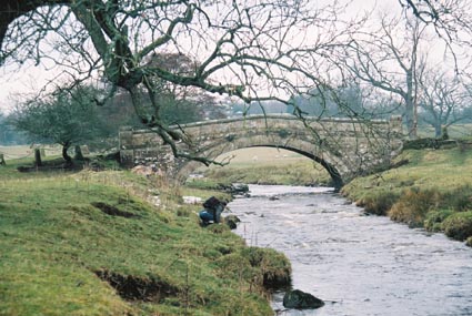
| Bridge 450 Metres South East of Nunwick Hall | 1370330 | II | C19th | Nunwick |
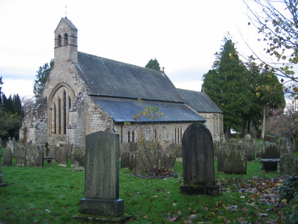
| Church of St Mungo | 1157154 | II* | C13th | Simonburn |
| Dinning Headstone 2 Metres South of Church of St Mungo | 1157200 | II | 1783 | Churchyard, St Mungo's |
| Dodd Headstone 13 Metres South of Church of St Mungo | 1302512 | II | 1783 | Churchyard, St Mungo's |
| Dovecote 75 Metres South-East of Low Park End and Dovecote | 1370306 | II | C18th | |
| East Stonefields Farmhouse and Attached Farmbuildings and Walls | 1245332 | II | C18th | |
| East Uppertown Farmhouse | 1045224 | II | C18th | |
| Fairshaw Farmhouse and Adjoining Farmbuilding on East | 1045211 | II | 1743 | |
| Farmbuildings Incorporating Barn, Byre and Smithy, East of Fairshaw Farmhouse | 1370328 | II | C18th | |
| Farmbuildings to North of Nos 1, 2 and 3 Townhead Farmhouses | 1302565 | II | C19th | |
| Garden House | 1157094 | II | c.1800 | Nunwick |
| Garden Walls with Privy Wash House and Shed to East of the Rectory | 1157223 | II | C18th | |
| Ha Ha Wall to East and South of Nunwick Hall | 1370329 | II | C18th | Nunwick |
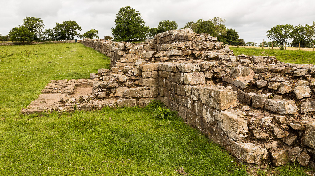
| Hadrians Wall, Milcastles and Turrets | 1045249 | I | Roman | Includes milecastles 30, 31, 34 and 35 |
| Headstone with Headless Figure 1 Metre South of Church of St Mungo | 1157188 | II | C18th | Churchyard, St Mungo's |
| Hemmels South of Fairshaw Farmhouse | 1045212 | II | C19th | |
| Kirkshield | 1302546 | II | 1775 | Folly Lane |
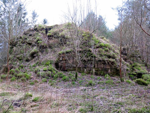
| Lime Kiln 300 Metres North-East of Great Lonbrough Farmhouse | 1045225 | II | C18th | |
| Lime Kiln 800 Metres West of Town Shields Farmhouse | 1370305 | II | C19th | |
| Little Park End | 1156562 | II | C18th | B6320 |
| Low Teppermoor Farmhouse and Adjoining Byre | 1156532 | II | C18th | B6318 |
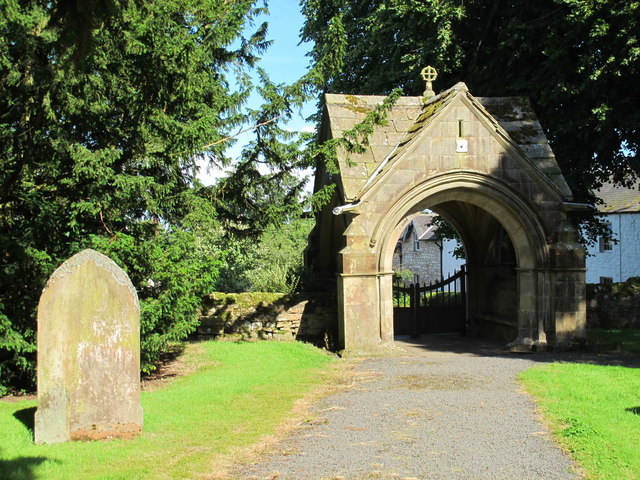
| Lych Gate to Church of St Mungo | 1370332 | II | 1885 | Simonburn |
| Middleton Headstone, 3 Metres South of Church of St Mungo | 1045218 | II | 1751 | Churchyard, St Mungo's |
| Milestone 60 Metres South of Garden House | 1045215 | II | C18th | Nunwick |
| Number 3 Red Lion Terrace Red Lion Cottage and Adjoining Farm Building | 1302554 | II | C19th | Simonburn, The Green |
| Nunwick Hall and Ranges Around Service Court | 1302602 | II* | 1752 | Nunwick |
| Nunwick Mill | 1156539 | II | C19th | Nunwick |
| Nunwick Mill House | 1045250 | II | C19th | Nunwick |
| Outbuildings (Including Rose Cottage) Around 2 Yards to North-West of Park End | 1370327 | II | C18th | |
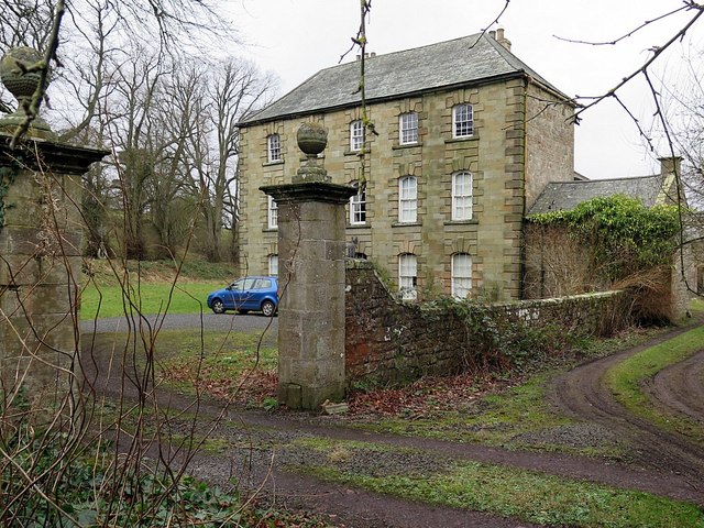
| Park End | 1045251 | II | C18th | Country House |
| Piers and Quadrant Walls 250 Metres West of Nunwick Hall | 1045213 | II | c.1800 | Nunwick |
| Rectory Terrace | 1045221 | II | C19th | Simonburn, The Green |
| Remains of Piers and Water Channel, North of Nunwick Mill | 1302826 | II | C19th | Nunwick |
| Ridley Headstone 1 Metre South of Church of St Mungo | 1045220 | II | 1750 | Churchyard, St Mungo's |
| Simonburn Bridge | 1178427 | II | C18th | Simonburn, Hall Bank |
| Simonburn Castle | 1302543 | II | C13th | Ruins |
| Spiral Column Near North-East Corner of Walled Garden in Nunwick Park | 1157032 | II | C17th | |
| Stewards House | 1045216 | II | C18th | |
| Tecket Farmhouse | 1370331 | II | C15th | |
| The Old Kennels Adjoining House and Yard Walls 60 Metres South East of Walled Garden in Nunwick Park | 1045214 | II | 1768 | Nunwick |
| The Rectory, Attached Archway and Rear Yard Walls with Outshuts | 1178407 | II | 1666 | Simonburn. Former rectory, now private house. |
| The Tithe Barn | 1045223 | II | C18th | Simonburn. Now a house. |
| Wall and Gate Piers Running South from the Rectory | 1045222 | II | C19th | |
| Wall, Coach House and Cart Shed Adjoining North Return of Park End | 1045210 | II | C19th | |
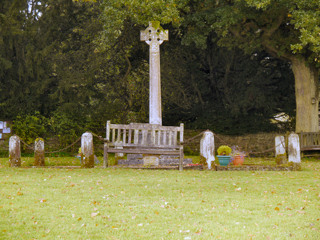
| War Memorial, Village Green | 1391546 | II | 1920 | Simonburn |
| Simonburn Castle tower house | 1012414 | n/a | Scheduled Monument | |
| Hadrian's Wall and vallum between Chesters and the road to Simonburn in wall miles 27, 28 and 29 | 1010960 | n/a | Roman | Scheduled Monument |
| Hadrian's Wall and vallum between the road to Simonburn and the field boundary east of Carrawburgh car park in wall miles 29, 30 and 31 | 1010961 | n/a | Scheduled Monument | |
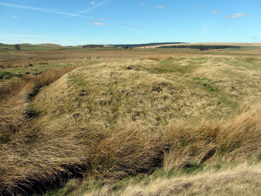
| Romano-British farmstead, 250m east of King's Crags | 1011074 | n/a | Romano-British | Scheduled Monument |
| Three round cairns, 500m east of King's Crags | 1011075 | n/a | Scheduled Monument | |
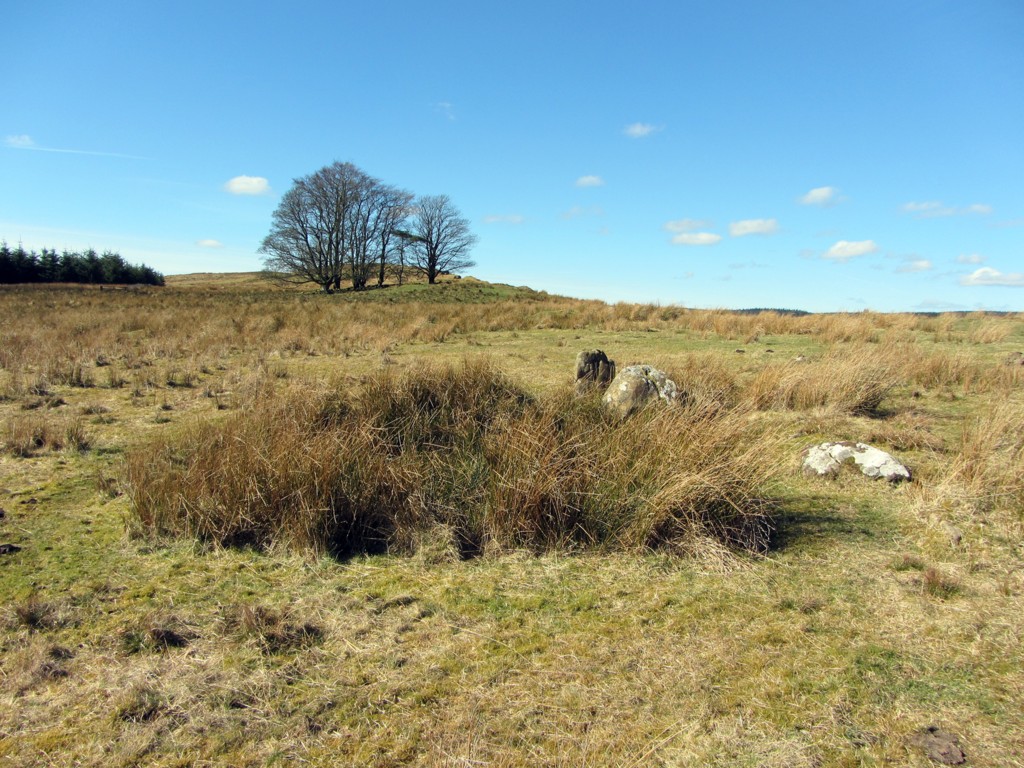
| Stone circle, 380m east of King's Crags | 1011076 | n/a | Bronze Age | Scheduled Monument |
| Round cairn, 120m south of King's Crags | 1011077 | n/a | Scheduled Monument | |
| Round cairn, 150m east of Kingscrag Gate | 1011078 | n/a | Scheduled Monument | |
| Round cairn, 120m ENE of Kingscrag Gate | 1011079 | n/a | Scheduled Monument | |
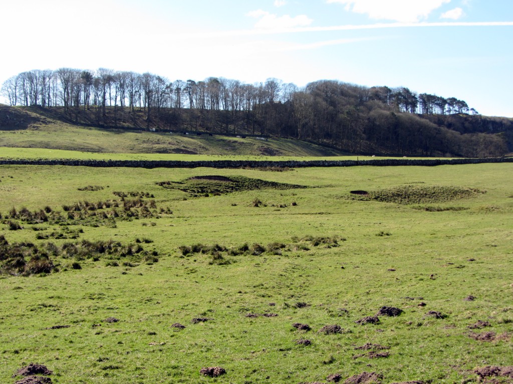
| Moated site and fishpond, 1km ENE of Sewingshields on Fozy Moss | 1011080 | n/a | Medieval | Scheduled Monument |
| Fishponds, 450m north-east of Sewingshields | 1011081 | n/a | Medieval | Scheduled Monument |
| Romano-British farmstead, 400m north-east of Sharpley | 1011082 | n/a | Romano-British | Scheduled Monument |
| Round cairn, 150m ESE of Kingscrag Gate | 1009467 | n/a | Scheduled Monument | |
| Carrawburgh Roman fort and Hadrian's Wall and vallum between the field boundary east of the fort and the field boundary west of Coventina's Well in wall mile 31 | 1015914 | n/a | Roman | Scheduled Monument |
| Hadrian's Wall and vallum between the field boundary at Brown Dikes and the field boundary east of turret 34a in wall miles 32, 33 and 34 | 1010963 | n/a | Roman | Scheduled Monument |
| Hadrian's Wall and associated features between the boundary east of turret 34a and the field boundary west of milecastle 36 in wall miles 34, 35 and 36 | 1010964 | n/a | Roman | Scheduled Monument |
Primary source: the National Heritage List for England - NHLE is the register of nationally protected historic buildings and sites in England, including listed buildings, scheduled monuments, protected wrecks, registered parks and gardens, and battlefields. The list is maintained by Historic England. Check NHLE for updates and new entries. Secondary sources: British Listed Buildings and Keys to the Past.
Co-Curate Page
Lych Gate to St Mungo's Church, Simonburn
- Overview Map Street View The Lych Gate forms the entrance to St Mungo's Church in Simonburn. It is inscribed: "To the Glory of God In memory of Lancelot John Hunter …
Co-Curate Page
Simonburn Castle
- Ruins of a 13th century tower house near Simonburn in Northumberland.
Co-Curate Page
War Memorial, Simonburn
- Overview Map Street View The War Memorial is located on a green on Castle Lane, near the entrance to St Mungo's Church, in Simonburn. It commemorates local men who served …
Co-Curate Page
Turret 29a (Black Carts)
- Overview Map Street View Turrets on Hadrian’s Wall were small watchtowers built into the wall, with two turrets per Roman mile, located between larger milecastles. They provided elevated viewpoints for …


Co-Curate Page
Wall Mile 29
- <Mile 28 | Mile 29 | Mile 30> Hadrian's Wall - Wall Mile 29 Hadrian's Wall stretches from the east to west coast of England and was an important frontier …

Co-Curate Page
Wall Mile 30
- <Mile 29 | Mile 30 | Mile 31> Hadrian's Wall - Wall Mile 30 Hadrian's Wall stretches from the east to west coast of England and was an important frontier …

Co-Curate Page
Wall Mile 31
- <Mile 30 | Mile 31 | Mile 32> Hadrian's Wall - Wall Mile 31 Hadrian's Wall stretches from the east to west coast of England and was an important frontier …
Co-Curate Page
Stone circle, east of King's Crags
- Scheduled Monument (#1011076): Stone circle, 380m east of King's Crags Click the headings below to expand (selected extracts from the Historic England scheduling) Significance The stone circle east of King's …
Co-Curate Page
Moated site and fishpond on Fozy Moss
- Scheduled Monument (#1011080): Moated site and fishpond, 1km ENE of Sewingshields on Fozy Moss Click the headings below to expand (selected extracts from the Historic England scheduling) Significance The moated …

Co-Curate Page
Romano-British farmstead, NE of Sharpley
- Map showing the Scheduled Monument area of the Romano-British farmstead, 400m north-east of the farm at Sharpley. Scheduled Monument (#1011082): Romano-British farmstead, 400m north-east of Sharpley Click the headings below …
Co-Curate Page
Romano-British farmstead, east of King's Crags
- Map showing the Scheduled Monument area for the Romano-British farmstead, 250m east of King's Crags Scheduled Monument (#1011074): Romano-British farmstead, 250m east of King's Crags Click the headings below to …
Co-Curate Page
Brocolitia Roman Fort
- Overview Map Street View Hadrian's Wall Glossary <Mile 30 | Mile 31 | Mile 32> Hadrian's Wall - Wall Mile 31 - Brocolitia Extract showing Brocolitia on old OS Map, …
Co-Curate Page
Fishponds, NE of Sewingshields
- Map showing the Scheduled Monument area for the Fishponds, 450m north-east of Sewingshields Scheduled Monument (#1011081): Fishponds, 450m north-east of Sewingshields Click the headings below to expand (selected extracts from …

Co-Curate Page
Lych Gate to St Mungo's Church, Simonburn
- Overview Map Street View The Lych Gate forms the entrance to St Mungo's Church in Simonburn. It is inscribed: "To the Glory of God In memory of Lancelot John Hunter …
Co-Curate Page
Simonburn Castle
- Ruins of a 13th century tower house near Simonburn in Northumberland.
Co-Curate Page
War Memorial, Simonburn
- Overview Map Street View The War Memorial is located on a green on Castle Lane, near the entrance to St Mungo's Church, in Simonburn. It commemorates local men who served …
Co-Curate Page
Turret 29a (Black Carts)
- Overview Map Street View Turrets on Hadrian’s Wall were small watchtowers built into the wall, with two turrets per Roman mile, located between larger milecastles. They provided elevated viewpoints for …
Co-Curate Page
Wall Mile 29
- <Mile 28 | Mile 29 | Mile 30> Hadrian's Wall - Wall Mile 29 Hadrian's Wall stretches from the east to west coast of England and was an important frontier …
Co-Curate Page
Wall Mile 30
- <Mile 29 | Mile 30 | Mile 31> Hadrian's Wall - Wall Mile 30 Hadrian's Wall stretches from the east to west coast of England and was an important frontier …
Co-Curate Page
Wall Mile 31
- <Mile 30 | Mile 31 | Mile 32> Hadrian's Wall - Wall Mile 31 Hadrian's Wall stretches from the east to west coast of England and was an important frontier …
Co-Curate Page
Stone circle, east of King's Crags
- Scheduled Monument (#1011076): Stone circle, 380m east of King's Crags Click the headings below to expand (selected extracts from the Historic England scheduling) Significance The stone circle east of King's …
Co-Curate Page
Moated site and fishpond on Fozy Moss
- Scheduled Monument (#1011080): Moated site and fishpond, 1km ENE of Sewingshields on Fozy Moss Click the headings below to expand (selected extracts from the Historic England scheduling) Significance The moated …
Co-Curate Page
Romano-British farmstead, NE of Sharpley
- Map showing the Scheduled Monument area of the Romano-British farmstead, 400m north-east of the farm at Sharpley. Scheduled Monument (#1011082): Romano-British farmstead, 400m north-east of Sharpley Click the headings below …
Co-Curate Page
Romano-British farmstead, east of King's Crags
- Map showing the Scheduled Monument area for the Romano-British farmstead, 250m east of King's Crags Scheduled Monument (#1011074): Romano-British farmstead, 250m east of King's Crags Click the headings below to …
Co-Curate Page
Brocolitia Roman Fort
- Overview Map Street View Hadrian's Wall Glossary <Mile 30 | Mile 31 | Mile 32> Hadrian's Wall - Wall Mile 31 - Brocolitia Extract showing Brocolitia on old OS Map, …


