Topics > Heritage Sites > Hadrian's Wall > Wall Mile 29
Wall Mile 29
Hadrian's Wall - Wall Mile 29
Hadrian's Wall stretches from the east to west coast of England and was an important frontier of the Roman Empire. Building of the wall began in AD 122 and took six years to complete it’s 84 mile (80 Roman mile) length. Soldiers were garrisoned along the line of the wall in large forts, smaller milecastles, and intervening turrets. The Vallum, a large ditch with mounds on either side, ran along the south side of the wall, protecting the rear of the frontier. Hadrian's Wall was designated as a World Heritage Site in 1987.
Wall Mile 29:
- Milecastle 29 (Tower Tye)
- Turret 29a (Black Carts)
- Turret 29b (Limestone Bank)
Scheduled Monument (#1010960): Hadrian's Wall and vallum between Chesters and the road to Simonburn in wall miles 27, 28 and 29
Click the headings below to expand (selected extracts from the Historic England scheduling)
Map showing Scheduled Monument area (Historic England data).
%
The monument includes the section of Hadrian's Wall and associated features between Chesters in the east and the minor road to Simonburn in the west. This section of the corridor occupies the steep valley side on the west bank of the North Tyne. Hadrian's Wall survives as a buried feature below grassland for most of this section. However, it is visible intermittently as an upstanding feature in two places.
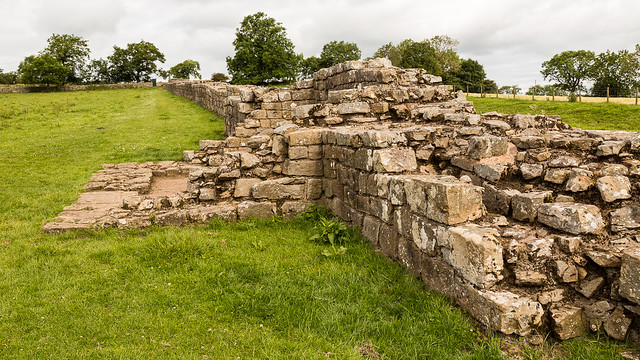
Hadrian's Wall survives as a buried feature below grassland for most of this section. However, it is visible intermittently as an upstanding feature in two places. In the grounds of Chesters house a short section of Wall, 13.5m long and up to 1.1m high, is exposed. Further west near Black Carts there is a section of consolidated Wall about 140m long. The south face averages 1.2m in height and the north face 1.9m.
The wall ditch survives intermittently as a well preserved feature throughout this section. There is little trace of it above ground through the gardens of Chesters house, however it will survive as a buried feature. At Walwick, houses and gardens have been built over the line of the Wall. Beyond Walwick the ditch is visible on the ground as a depression partly overgrown by scrub and small trees. It averages about 1.7m in depth, though it reaches a maximum of 3.1m in places. The upcast mound from the ditch, known as the glacis, has been mostly ploughed out. However, it does survive well east of milecastle 29 where it reaches a height of 3.5m.
Milecastle 29, or Tower Tye, survives as a series of clearly defined robber trenches on all sides. According to Hodgson, who investigated the milecastle during 1840, the dimensions were found to be 50.4m north-south by 46.4m east-west.
Turret 29a, or Black Carts, survives well as an upstanding feature. It is located about 100m east of the minor road to Simonburn with wide views to the north, east and south. It was excavated in 1873 and again in 1971 before it was consolidated. Internally the turret measures 3.45m by 3.4m and is of a type thought to have been built by the twentieth legion.
See our page: Turret 29a (Black Carts)
The course of the Roman road known as the Military Way, which ran along the corridor between the Wall and the vallum linking turrets, milecastles and forts, is not yet known with certainty. It does not survive as a feature visible on the ground. However, according to Horsley writing in 1732, the Military Way in this section followed the line of the north mound of the vallum except for where it veered towards milecastles. The present B6318 road overlies the north mound of the vallum, and therefore remains of the Military Way may survive below the modern surface.
The vallum is visible as an upstanding earthwork throughout much of this section, though in the stretch between Chesters and Towertie Plantation it has been largely ploughed out. Beyond Walwick the north mound of the vallum is overlain by the B6318 road. Here the vallum ditch averages between 1.5m and 2m in depth while the south mound averages about 2m in height except for where it has been reduced by ploughing.
Scheduled Monument (#101096): Hadrian's Wall and vallum between the road to Simonburn and the field boundary east of Carrawburgh car park in wall miles 29, 30 and 31
Click the headings below to expand (selected extracts from the Historic England scheduling)
Map showing the Scheduled Monument area (Historic England data).
%
The monument includes the section of Hadrian's Wall and associated features between the minor road to Simonburn in the east and the field boundary to the east of Carrawburgh car park in the west. This section of the Wall follows an alignment straight from the North Tyne to the high point at Limestone Corner where it changes to a more westerly direction and occupies the gentle west facing slope all the way to Carrawburgh. There are good views to the north and south all along this section, and in particular from Limestone Corner. All the upstanding remains of Hadrian's Wall, the milecastles and turrets in this scheduling are Listed Grade I. The Wall survives as a buried feature for most of this section, except for the two well preserved sections west of the minor road to Simonburn.
The Wall survives as a buried feature for most of this section, except for the two well preserved sections west of the minor road to Simonburn. The two upstanding sections of Wall are consolidated and in the care of the Secretary of State. The east section is about 122m long and reaches a maximum height of 1.8m. The west section is about 48m in length and slightly lower. Elsewhere the Wall is visible as a low stony bank with a maximum height of 1m, or as a trench with spoil heaps either side of it. These trenches are the result of excavation in 1951 to either side of milecastle 30, when it was shown that the Wall in this section was narrow wall on a broad wall foundation. Beyond Limestone Corner the line of the Wall is overlain by the B6318 road and there are no upstanding remains visible.
The outer ditch survives well throughout this section and averages over 2m deep. The ditch is most impressive at Limestone Corner where it has been cut through the bedrock to a maximum depth of 2.8m. To the east of Limestone Corner the rock-cut ditch was left unfinished. The upcast mound from the ditch, known as the glacis, survives intermittently throughout this section. It is best preserved west of Limestone Corner where it attains a height of 2.7m.
Turret 29b survives as a turf covered mound with parts of the north, west and east walls surviving up to two courses. The road connecting the turret to the Military Way is discernible as a slight linear mound. It was excavated during 1912 by Newbold who found the doorway in the east end of the south side and a ladder platform in the south west corner. Heavily burnt masonry and rubbish indicated that the turret had been destroyed by fire and was then left in ruins.
The course of the Roman road known as the Military Way, which ran along the corridor between the Wall and the vallum linking turrets, milecastles and forts, is not known with certainty for most of this section. However, according to the observations of Horsley made in the 1730s and trial excavations by Newbold in the early 1900s, it is generally considered that the Military Way overlay the north mound of the vallum for most of this section. Further excavations in 1911 confirmed this interpretation. For this reason it is believed that the B6318 road overlies it between Chesters and Limestone Corner. At Limestone Corner the Military Way is visible as a low causeway, 0.6m high, leading to the south gateway of milecastle 30. Beyond the milecastle it rejoins the north mound of the well preserved vallum. Excavations during 1911 confirmed this to be the case.
The vallum is very well preserved throughout this section. It survives as a series of upstanding earthworks and an impressive rock cut ditch around Limestone Corner. The north mound averages 1.2m for most of its length where it is not overlain by the B6318. The south mound averages about 1m in height with crossings identifiable about every 42m. The ditch is mainly rock cut in the east half of this section with sheer sides and depths of up to 3.5m. In the west half of this section the ditch also survives well and averages 1.9m in depth.


from https://historicengland.org.u…
Hadrian's Wall and vallum between the road to Simonburn and the field boundary east of Carrawburgh car park in wall miles 29, 30 and 31 - List Entry
- ...Hadrian's Wall and its associated works between the minor road to Simonburn and the field boundary east of Carrawburgh car park survive well as upstanding and buried features for most …
Added by
Simon Cotterill
from https://historicengland.org.u…
Hadrian's Wall and vallum between Chesters and the road to Simonburn in wall miles 27, 28 and 29 - List Entry
- ...Hadrian's Wall and its associated works between Chesters and the minor road to Simonburn survive intermittently as upstanding monuments and as buried features. There is one particularly well preserved section …
Added by
Simon Cotterill

from https://historicengland.org.u…
Hadrian's Wall and vallum between the road to Simonburn and the field boundary east of Carrawburgh car park in wall miles 29, 30 and 31 - List Entry
- ...Hadrian's Wall and its associated works between the minor road to Simonburn and the field boundary east of Carrawburgh car park survive well as upstanding and buried features for most …
Added by
Simon Cotterill
from https://historicengland.org.u…
Hadrian's Wall and vallum between Chesters and the road to Simonburn in wall miles 27, 28 and 29 - List Entry
- ...Hadrian's Wall and its associated works between Chesters and the minor road to Simonburn survive intermittently as upstanding monuments and as buried features. There is one particularly well preserved section …
Added by
Simon Cotterill