Topics > Heritage Sites > Hadrian's Wall > Wall Mile 27
Wall Mile 27
Hadrian's Wall - Wall Mile 27
Hadrian's Wall stretches from the east to west coast of England and was an important frontier of the Roman Empire. Building of the wall began in AD 122 and took six years to complete it’s 84 mile (80 Roman mile) length. Soldiers were garrisoned along the line of the wall in large forts, smaller milecastles, and intervening turrets. The Vallum, a large ditch with mounds on either side, ran along the south side of the wall, protecting the rear of the frontier. Hadrian's Wall was designated as a World Heritage Site in 1987.
Wall Mile 27:
- Chesters Fort
- Chesters Bridge
- Milecastle 27 (Low Brunton)
- Turret 27a
- Turret 27b
The museum at Chesters opened in 1903 and includes many of the Roman artifacts collected by John Clayton, who inherited the Chesters estate in 1843 and played a major role in preserving Hadrian's Wall.
Scheduled Monument (#1018581): Hadrian's Wall and vallum between St Oswald's Cottages, east of Brunton Gate and the North Tyne in wall miles 25, 26 and 27
Click the headings below to expand (selected extracts from the Historic England scheduling)
Map showing Scheduled Monument area (Historic England data), with additional markers.
%
The monument includes the stretch of Hadrian's Wall, vallum and associated features between St Oswald's Cottages, east of Brunton Gate in the east and the River North Tyne in the west. This section occupies the west-facing side of the North Tyne valley. Hadrian's Wall bends slightly northwards at Dixon's Plantation and then follows a straight alignment all the way down to the crossing of the North Tyne. The B6318 road runs to the north of the Wall line for most of this section.
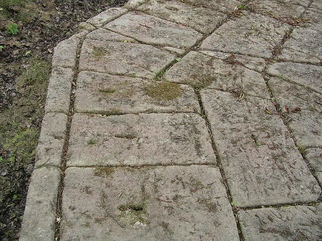
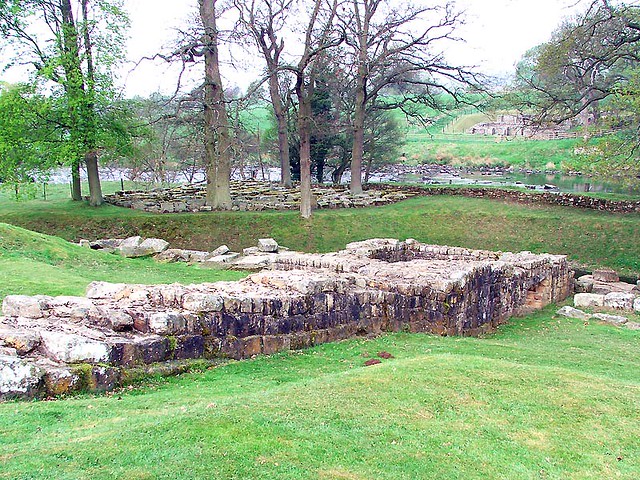
Milecastle 27, or 'Low Brunton' is situated on level ground on the east bank of the North Tyne. It is visible as a low, almost square, platform with a maximum height of 0.4m. The milecastle was partly excavated in 1952, and was shown to have a clay bonded wall core.
Scheduled Monument (#1010959): The Roman fort, vicus, bridge abutments and associated remains of Hadrian's Wall at Chesters in wall mile 27
Click the headings below to expand (selected extracts from the Historic England scheduling)
Map showing Scheduled Monument area (Historic England data) with the additional highlighting of the fort area.
%
The monument includes the section of Hadrian's Wall and associated features from the bridge abutment on the east bank of the River North Tyne in the east to the woodland on the east side of the Chesters property in the west. This section of frontier, which includes Chesters fort (known to the Romans as Cilurnum) occupies a broad stretch of river terrace on the west bank of the North Tyne. The Wall is visible intermittently as an upstanding feature in this section.
Short sections of Wall are upstanding at the junctions with the fort on the south sides of the east and west gateways. There is a 6.7m length of consolidated Wall to the east of the fort which is in the care of the Secretary of State. West of the fort the Wall line is denoted by an amorphous, discontinuous mound up to 0.4m in height. There are no visible upstanding remains west of the ha-ha (sunken wall), which forms an element of the landscape gardens of Chester House. The wall ditch is discernible to the east of the fort as a ploughed down upcast scarp. For the most part it survives as a silted up feature below the surface. To the west of the fort the ditch survives as a discontinuous depression, 0.3m deep.
Turret 27a which occupied part of the site before the fort was built was discovered by excavation during 1945. It was found to lie about 42m west of the inner face of the east gateway.
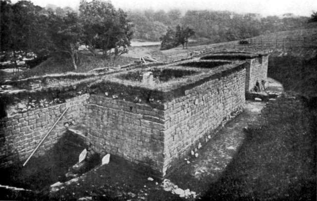
The bridge abutments and piers which carried the Wall and Military Way over the River North Tyne survive well as upstanding monuments. These features are now consolidated and in the care of the Secretary of State. There is also a section of consolidated Wall and tower base adjoining the east bridge abutment on its west side. These features are also in the care of the Secretary of State. Excavations of the abutments by Bidwell and Holbrook during 1990 have shown that there were two clear phases to the bridge; the early Hadrianic structure and the larger and more imposing one of third century AD.
See our page: Chesters Bridge Abutment
The precise location of the vallum around Chesters has not yet been confirmed. Aerial photographs show the possible start of it from near the west bank of the North Tyne, but around the fort the course is conjectural.
The course of the Roman road known as the Military Way, which ran along the corridor between the Wall and the vallum linking turrets, milecastles and forts, survives well in the section between the North Tyne and the fort. The line of the road is clearly defined on the ground leaving the fort by the east gateway and heading towards the Roman bridge. Initially it is a depression and then becomes a causeway with a maximum height of 0.8m with a kerb to the south visible for 1.3m.
There are no upstanding remains of the road to the west of the fort. However, the antiquarian Horsley considered that the Military Way exited Chesters and then converged gradually with the north mound of the vallum where they continued united for a considerable distance.
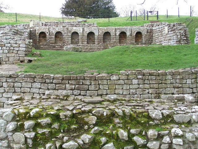
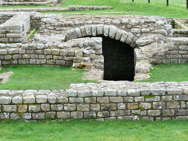
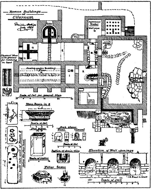
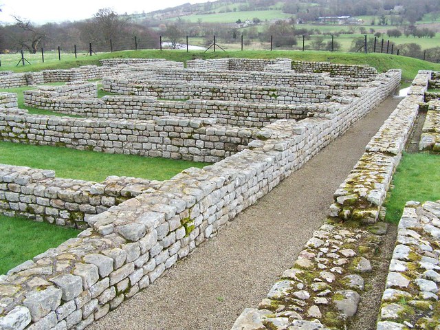
The Roman fort at Chesters, which is in the care of the Secretary of State, was built to guard the North Tyne crossing of the Wall. Excavation has demonstrated that the fort was constructed after, and overlies, the Wall. It encloses an area of 2.1ha. The fort wall is exposed in a number of places round the circuit. Elsewhere the outline of the fort is shown by a scarp which survives to a maximum height of about 2m.
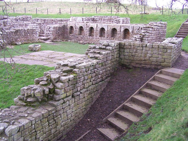
The upstanding masonry is best preserved in the south east corner where it survives to a height of 1.9m. Well preserved visible remains in the interior include the consolidated remains of the headquarters building, commanding officer's house and some barrack blocks. Buried remains will survive below the ridge and furrow cultivation inside the fort.
The site has been excavated at various times from 1796 up to the most recent investigations during 1990-91. Extensive amorphous earthworks within the fort probably show the position of the backfilled trenches and spoilheaps, resulting from the various excavations.
See our page: Chesters Roman Fort
An extensive civil settlement, or vicus, is located outside the fort on the south side. It occupies an area of level ground bordered to the east by the steep cliff down to the river's edge. Its buildings and roads are known largely from the evidence of aerial photographs. The settlement is orientated around the road leading south from the fort and a road which bisects it at right angles. A well, believed to be Roman, survives as an upstanding feature immediately outside the garden of Chesters house.
The well preserved remains of a bath house are visible to the east of the fort about 30m uphill from the present course of the river. It had a paved floor, hypocaust and an outflow drain, as well as various hot and cold rooms. An interesting and unique feature of this bath house is that when it was discovered in the 1880s the remains of 33 human skeletons, two horses and a dog were found. There is a however some doubt as to exactly where around the bath house they were found.
A quantity of monumental masonry has been found by the river at the point where the ha-ha wall joins its bank, suggesting that this was the location of the cemetery. More recently an altar has been found in the river bank closer to the fort together with a fragment of architectural masonry.
A road runs from the south gateway of the fort to the Stanegate Roman road which lies further south. Aerial photography has shown that this road runs along the crest of the river bank south of the ha-ha wall.
Scheduled Monument (#1010960): Hadrian's Wall and vallum between Chesters and the road to Simonburn in wall miles 27, 28 and 29
Click the headings below to expand (selected extracts from the Historic England scheduling)
Map showing Scheduled Monument area (Historic England data).
%
The monument includes the section of Hadrian's Wall and associated features between Chesters in the east and the minor road to Simonburn in the west. This section of the corridor occupies the steep valley side on the west bank of the North Tyne. Hadrian's Wall survives as a buried feature below grassland for most of this section. However, it is visible intermittently as an upstanding feature in two places.
Hadrian's Wall survives as a buried feature below grassland for most of this section. However, it is visible intermittently as an upstanding feature in two places. In the grounds of Chesters house a short section of Wall, 13.5m long and up to 1.1m high, is exposed. Further west near Black Carts there is a section of consolidated Wall about 140m long. The south face averages 1.2m in height and the north face 1.9m.
The wall ditch survives intermittently as a well preserved feature throughout this section. There is little trace of it above ground through the gardens of Chesters house, however it will survive as a buried feature. At Walwick, houses and gardens have been built over the line of the Wall. Beyond Walwick the ditch is visible on the ground as a depression partly overgrown by scrub and small trees. It averages about 1.7m in depth, though it reaches a maximum of 3.1m in places. The upcast mound from the ditch, known as the glacis, has been mostly ploughed out. However, it does survive well east of milecastle 29 where it reaches a height of 3.5m.
The precise location of turret 27b has not yet been confirmed. However, its predicted location, on the basis of the usual spacing, is in the grounds of Chesters house. It may survive as a buried feature.
The course of the Roman road known as the Military Way, which ran along the corridor between the Wall and the vallum linking turrets, milecastles and forts, is not yet known with certainty. It does not survive as a feature visible on the ground. However, according to Horsley writing in 1732, the Military Way in this section followed the line of the north mound of the vallum except for where it veered towards milecastles. The present B6318 road overlies the north mound of the vallum, and therefore remains of the Military Way may survive below the modern surface.
The vallum is visible as an upstanding earthwork throughout much of this section, though in the stretch between Chesters and Towertie Plantation it has been largely ploughed out. Beyond Walwick the north mound of the vallum is overlain by the B6318 road. Here the vallum ditch averages between 1.5m and 2m in depth while the south mound averages about 2m in height except for where it has been reduced by ploughing.


Co-Curate Page
Chesters Roman Fort
- Overview About Chesters (Cilurnum) Map Chesters Roman Fort and Museum, managed by English Heritage, is located near Walwick and Chollerford in Northumberland. The Roman cavalry fort (Cilurnum) was built in …
Co-Curate Page
Chesters Bridge Abutment
- Overview Map Close to Chesters Roman Fort are the remains of a bridge which carried Hadrian's Wall across the River North Tyne.

from https://historicengland.org.u…
Hadrian's Wall and vallum between Chesters and the road to Simonburn in wall miles 27, 28 and 29 - List Entry
- ...Hadrian's Wall and its associated works between Chesters and the minor road to Simonburn survive intermittently as upstanding monuments and as buried features. There is one particularly well preserved section …
Added by
Simon Cotterill
from https://historicengland.org.u…
Hadrian's Wall and vallum between St Oswald's Cottages, east of Brunton Gate and the North Tyne in wall miles 25, 26 and 27 - List Entry
- ".....The monument includes the stretch of Hadrian's Wall, vallum and associated features between St Oswald's Cottages, east of Brunton Gate in the east and the River North Tyne in the …
Added by
Simon Cotterill
from https://historicengland.org.u…
The Roman fort, vicus, bridge abutments and associated remains of Hadrian's Wall at Chesters in wall mile 27 - List Entry
- ...The wall fort, its associated civil settlement and the remains of the bridge, survive well as both upstanding and buried remains. Chesters is one of the best surviving examples of …
Added by
Simon Cotterill


from https://perlineamvalli.wordpr…
Wall Mile 27 (East to West)
- Wall Mile 27 (January 28, 2013). Mike Bishop's PLV blog about walking Hadrian’s Wall written from an archaeologist’s point of view. "....The bridge abutment nestles in a copse of trees …
Added by
Simon Cotterill

Co-Curate Page
Chesters Roman Fort
- Overview About Chesters (Cilurnum) Map Chesters Roman Fort and Museum, managed by English Heritage, is located near Walwick and Chollerford in Northumberland. The Roman cavalry fort (Cilurnum) was built in …
Co-Curate Page
Chesters Bridge Abutment
- Overview Map Close to Chesters Roman Fort are the remains of a bridge which carried Hadrian's Wall across the River North Tyne.
from https://historicengland.org.u…
Hadrian's Wall and vallum between Chesters and the road to Simonburn in wall miles 27, 28 and 29 - List Entry
- ...Hadrian's Wall and its associated works between Chesters and the minor road to Simonburn survive intermittently as upstanding monuments and as buried features. There is one particularly well preserved section …
Added by
Simon Cotterill
from https://historicengland.org.u…
Hadrian's Wall and vallum between St Oswald's Cottages, east of Brunton Gate and the North Tyne in wall miles 25, 26 and 27 - List Entry
- ".....The monument includes the stretch of Hadrian's Wall, vallum and associated features between St Oswald's Cottages, east of Brunton Gate in the east and the River North Tyne in the …
Added by
Simon Cotterill
from https://historicengland.org.u…
The Roman fort, vicus, bridge abutments and associated remains of Hadrian's Wall at Chesters in wall mile 27 - List Entry
- ...The wall fort, its associated civil settlement and the remains of the bridge, survive well as both upstanding and buried remains. Chesters is one of the best surviving examples of …
Added by
Simon Cotterill
from https://perlineamvalli.wordpr…
Wall Mile 27 (East to West)
- Wall Mile 27 (January 28, 2013). Mike Bishop's PLV blog about walking Hadrian’s Wall written from an archaeologist’s point of view. "....The bridge abutment nestles in a copse of trees …
Added by
Simon Cotterill

")

