Topics > Heritage Sites > Hadrian's Wall > Wall Mile 13
Wall Mile 13
Hadrian's Wall - Wall Mile 13
Hadrian's Wall stretches from the east to west coast of England and was an important frontier of the Roman Empire. Building of the wall began in AD 122 and took six years to complete it’s 84 mile (80 Roman mile) length. Soldiers were garrisoned along the line of the wall in large forts, smaller milecastles, and intervening turrets. The Vallum, a large ditch with mounds on either side, ran along the south side of the wall, protecting the rear of the frontier. Hadrian's Wall was designated as a World Heritage Site in 1987.
Wall Mile 13:
- Milecastle 13 (Rudchester Burn)
- Turret 13A (Rudchester East)
- Turret 13B (Rudchester West)
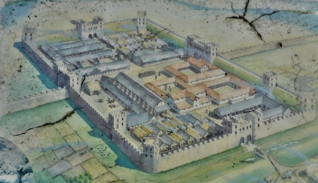
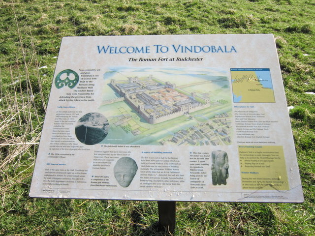
- Rudchester Roman Fort (Vindobala)
Scheduled Monument (#1017533): Rudchester Roman fort, associated civil settlement and a section of Hadrian's Wall and vallum from the A69 to the March Burn in wall mile 13
Click the headings below to expand (selected extracts from the Historic England scheduling)
The monument includes the wall fort at Rudchester, the associated civil settlement and the stretch of Hadrian's Wall and vallum between the A69 in the east and the March Burn in the west. This section of wall corridor runs up the west side of the valley of the Rudchester Burn to the slight rise occupied by the fort before descending the slight depression to the March Burn. Throughout this section there are limited views to the north where the ground slopes gently away. In contrast there are wide views to the south over the Tyne Valley, while to the east and west the views are more restricted.
In this section the Wall survives as a buried feature, lying below the course of the B6318 road. Excavations of milecastle 13 in 1930 demonstrated that the Wall was of broad type throughout this section.
The wall ditch has entirely silted up throughout this section except for a slight scarp on the east bank of the March Burn.
Milecastle 13, east of the Rudchester Burn, survives as a low mound 0.2m to 0.4m high. This milecastle measures 16.5m north to south by about 19m east to west. A large hoard of gold and silver coins was found here in 1776, the latest coins dating to AD 168. This milecastle was partly excavated in 1930 by Simpson.
Turret 13a, east of Rudchester fort, survives as a buried feature beneath the B6318 road. Part excavation by Simpson in 1930 revealed the turret walls which were built to a thickness of about 1.25m.
Turret 13b, which lies about 75m to the west of Rudchester fort, also survives as a buried feature beneath the B6318.
The vallum survives as an upstanding earthwork throughout this section. However, to the west of the fort there are no upstanding remains of the vallum, although it survives as a series of buried features, which were located in 1987 during a seismic survey. It was revealed that the vallum makes a dog-leg to avoid the western and southern sides of the fort. On the east side the north and south mounds of the vallum reach a maximum height of 1m, while the vallum ditch has a maximum depth of 1.4m.
The course of the Roman road known as the Military Way, which ran along the corridor between the Wall and the vallum linking the turrets, milecastles and forts, is not yet confirmed in this section of the corridor.
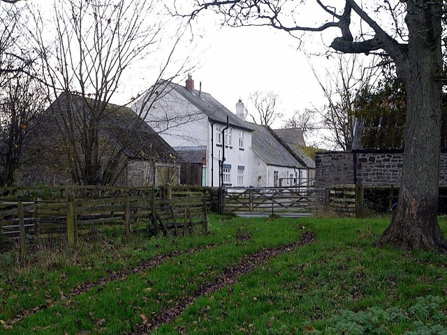
The Roman fort at Rudchester, known to the Romans as `Vindovala', survives as a turf-covered platform, up to 1.6m high, to the north of Rudchester Farm. It covers an area of 1.8ha and would have accommodated a part mounted cohort, 500 strong.
The site was very well preserved until the 18th century when it was reduced by stone robbing. This was followed by ploughing and cultivation of the area, which accounts for the ridge and furrow overlying the southern part of the fort.
It has been partly excavated on several occasions since 1897. Buildings identified as the Commanding Officer's house, the Headquarters Building and a granary, were located. Finds from the site include a life-size statue of Hercules, five altars dedicated to Mithras and pottery. The east and west gateways were positioned to the north of where Hadrian's Wall adjoined the fort.
See our page: Vindobala
The outlying civil settlement, or 'vicus', is located to the south and south west of the fort partly below the Rudchester Farm buildings. Post-medieval quarrying to the south east of the fort has probably destroyed some of the remains. The terraces which stretch to the west of Rudchester Farm are identified as evidence of the attached Roman civil settlement. They include some probable building platforms. Although mostly between 0.3m and 1.5m high, these terraces reach a maximum height of 3.2m in places and contain considerable quantities of stone.
A rock-cut cistern known as the 'Giants Grave' measures 3.9m by 1.5m internally and is at least 0.5m deep. It is located in the area of woodland to the west of Rudchester Farm and probably supplied part of the vicus with water, as indicated by the presence of a drainage hole in its north west corner.
A Roman temple dedicated to the Persian god Mithras is located to the south west of the fort in the vicus area. It has been partly overlain by a lynchet and bank. The temple is almost rectanglular in shape with a small apse at the north west end and an entrance hall at the south east end. The maximum internal dimensions of the building are approximately 7.3m by 16.4m. The surviving lower courses of the walls are made of stone. The building was excavated in 1953 by Gillam and MacIvor who were able to determine the plan of the temple, except for its south west corner which had been lost in a land slip.
Scheduled Monument (#1010618): Hadrian's Wall and vallum between the March Burn and Oatens Bank, Harlow Hill in wall miles 13,14 and 15
Click the headings below to expand (selected extracts from the Historic England scheduling)
The monument includes Hadrian's Wall and vallum and associated features between the March Burn in the east and the west side of Oatens Bank, Harlow Hill the west. This section of the Wall runs gently downhill from the March Burn to milecastle 15 before running up a steep gradient to the summit of Harlow Hill. The Wall commands wide views to the north and south along this section, but the undulating terrain to the east and west means that views are restricted in these directions. Hadrian's Wall aims for the high points throughout this section which includes the summits of Eppies Hill and Harlow Hill, unlike the vallum which takes a lower course skirting to the south of Harlow Hill. The Wall survives beneath the B6318 road throughout the whole length of this section.
For more detail on this section see: Wall Mile 14


from https://historicengland.org.u…
Rudchester Roman fort, associated civil settlement and a section of Hadrian's Wall and vallum from the A69 to the March Burn in wall mile 13
- "...The wall fort at Rudchester, its associated civil settlement and Hadrian's Wall and vallum from the A69 to the March Burn, survive well as upstanding turf-covered features. Rudchester is one …
Added by
Simon Cotterill
from Flickr (flickr)
Hadrians Wall, MC 13, Vindobala Roman Fort, Rudchester, 24102019 (5)
Pinned by Simon Cotterill
Co-Curate Page
Vindobala
- Overview About Vindobala Map Street View Vindobala (Brytonnic Celtic : windo- fair, white, bala place, situation?, cf. Old Irish bal, bail place, situation, condition, (good) luck) was a Roman …
from https://historicengland.org.u…
Hadrian's Wall and vallum between the March Burn and Oatens Bank, Harlow Hill in wall miles 13,14 and 15 - List Entry
- ....The section of Wall and vallum between the March Burn and Oatens Bank, Harlow Hill survives as a series of buried and upstanding features. Significant information on the development of …
Added by
Simon Cotterill

from https://historicengland.org.u…
Rudchester Roman fort, associated civil settlement and a section of Hadrian's Wall and vallum from the A69 to the March Burn in wall mile 13
- "...The wall fort at Rudchester, its associated civil settlement and Hadrian's Wall and vallum from the A69 to the March Burn, survive well as upstanding turf-covered features. Rudchester is one …
Added by
Simon Cotterill
from Flickr (flickr)
Hadrians Wall, MC 13, Vindobala Roman Fort, Rudchester, 24102019 (5)
Pinned by Simon Cotterill
Co-Curate Page
Vindobala
- Overview About Vindobala Map Street View Vindobala (Brytonnic Celtic : windo- fair, white, bala place, situation?, cf. Old Irish bal, bail place, situation, condition, (good) luck) was a Roman …
from https://historicengland.org.u…
Hadrian's Wall and vallum between the March Burn and Oatens Bank, Harlow Hill in wall miles 13,14 and 15 - List Entry
- ....The section of Wall and vallum between the March Burn and Oatens Bank, Harlow Hill survives as a series of buried and upstanding features. Significant information on the development of …
Added by
Simon Cotterill